
Culver Down rises in a chalky sweep above Sandown Bay on the Isle of Wight’s east coast, its white cliffs and hilltop monument visible for miles along the shoreline. For walkers, this compact headland offers a surprisingly varied mix of clifftop trails, historic sites and big-sky sea views, with paths that can be as gentle or as challenging as you choose to make them. From short evening strolls above Yaverland Beach to full-day hikes that link Bembridge, Whitecliff Bay and the Isle of Wight Coast Path, Culver Down is one of the island’s most rewarding places to lace up your boots.
Getting Oriented: Why Culver Down Is a Walkers’ Gem
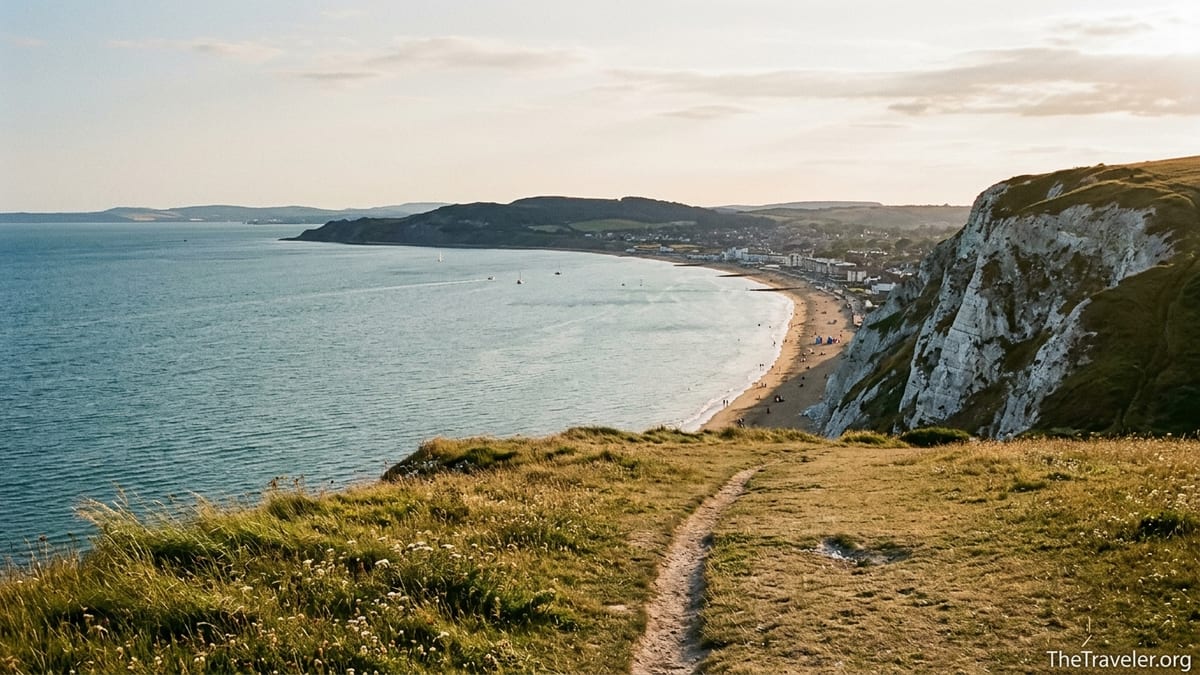
Culver Down is a chalk headland at the eastern end of the Isle of Wight, just north of Sandown and west of Bembridge. The downs here rise to around 100 metres above sea level, forming the dramatic white face of Culver Cliff that walkers see from Yaverland Beach and Sandown seafront. On the plateau, short turf and open access land create an almost upland feel, with wide horizons and constant sea air, while the Isle of Wight Coast Path skirts the clifftop edge on its journey between Bembridge and Sandown.
The area is compact enough that most visitors experience it as a half-day or full-day outing, yet the variety of trails means you can easily come back several times and walk a different loop each visit. The National Trust manages much of the downland and promotes a short “circumnavigate Culver Down” trail that showcases the best features: Bembridge Fort on the crest, the Yarborough Monument near the road summit, and panoramic views across Sandown Bay to Shanklin and the Ventnor Downs beyond.
Access is straightforward. Many walkers start from the small pay-and-display car park on Down Road above Sandown or from parking areas near the Yarborough Monument, while others climb up from Yaverland Beach or Whitecliff Bay holiday parks on steeper paths. For visitors staying without a car in Sandown, Shanklin or Bembridge, local Southern Vectis buses typically run to stops within walking distance of the downs; from central Sandown, for instance, you can reach the foot of the hill near Yaverland in around 25 minutes on foot before beginning the main ascent.
What sets Culver Down apart is the way coastal scenery, human history and easy access intersect in such a small area. Within a few kilometres of walking you can stand on Victorian ramparts at Bembridge Fort, look out over the tidal wetlands of Brading Marshes, trace the arc of the bay towards the chalk stacks at Freshwater in the far distance, and finish with fish and chips on Sandown pier as the sun drops behind the downs you have just explored.
The Classic Circuit: Circumnavigating Culver Down
The flagship walk for many visitors is the circular route that loops around the crown of Culver Down, often called the “circumnavigate Culver Down” trail. The National Trust suggests it as a short but exhilarating clifftop outing, typically 3 to 4 kilometres depending on where you start, with modest ascent of around 75 metres. It is achievable in about 1 to 1.5 hours at an easy pace, though photographers and families with children often take longer to linger at viewpoints and information boards.
A popular version begins from the main downland car park on Down Road above Yaverland. From here, waymarked paths lead you gently uphill through open grassland towards Bembridge Fort, a Victorian Palmerston fort completed in the 1860s. As you approach, the path gives you simultaneous views north over Bembridge Harbour and the Solent and south over the deep curve of Sandown Bay. On clear days you can often pick out the Spinnaker Tower in Portsmouth to the north and the hazy outline of the mainland coast beyond.
Skirting the outer ditch of Bembridge Fort, the trail swings towards the Yarborough Monument, a tall stone column commemorating the first Earl of Yarborough and used by sailors offshore as a navigational mark. The short stretch of minor road between the monument and the car park is shared with vehicles, but traffic is usually slow and light, especially outside peak school holiday periods. Walkers who prefer to avoid road walking can keep to grassy paths that parallel the tarmac for most of this section, making the circuit feel more like a continuous downland ramble than a roadside amble.
From near the monument the route rejoins the clifftop, offering what many regular Isle of Wight walkers consider one of the finest views on the island: the entire sweep of Sandown Bay from Yaverland to Shanklin, framed by chalk cliffs and sandy beaches, with yachts and cross-Channel ferries visible far out to sea. This south-facing slope catches the sun most of the day, and in late spring and early summer the downland is dotted with wildflowers and butterflies. The path here is generally wide and grassy, but in places it runs closer to the edge, so most guidebooks recommend keeping dogs and small children on the landward side and being cautious after prolonged rain when the chalk can be slippery.
Linking Coast and Downs: Yaverland, Sandown and Whitecliff Bay
One of the pleasures of walking around Culver Down is how easily you can combine high-level paths with time on the beach. Many visitors staying in Sandown or at Yaverland start their day with a flat stroll along the promenade before tackling the more strenuous climb up to the downs. From the eastern end of Yaverland car park, a signed path leads up through scrub and open grassland towards the ridge; the ascent is relatively short but can feel steep, so a pair of light hiking shoes with decent grip is helpful, particularly if you are carrying picnic supplies or walking with children.
Once you gain the ridge, a simple out-and-back route along the clifftop towards the Yarborough Monument offers wide open views with minimal navigation. On warm summer evenings, local residents often walk up from Sandown with a takeaway coffee or ice cream, sit near the monument to watch the light change on the bay, and then descend as the streetlights flicker on along the seafront. If you visit in high season, a good practical rhythm is to do the climb early or late in the day when the sun is softer and the air cooler, spending the hotter midday hours back down at sea level where you can dip in and out of the water.
On the north side of the headland, paths drop down towards Whitecliff Bay, a more sheltered cove served by holiday parks on the slopes behind the beach. Walking guides often describe a circuit that starts from these parks, climbs to the Yarborough Monument, then follows the clifftop before looping back through open downland to the starting point. For day-trippers, this offers a classic “sea-and-downs” combination: you might, for example, park near the holiday park access road, walk a 2 to 3 hour loop taking in the monument and fort, then end with a swim or a beach café stop at Whitecliff Bay.
Further variations are possible if you include Sandown itself. A full half-day outing could see you begin at Sandown pier, follow the shore or promenade to Yaverland, ascend to the downs, make a circuit past Bembridge Fort and the monument, then return via a different descent path to Yaverland before finishing back in town. In practice that might be 10 to 12 kilometres of walking with a couple of sustained climbs, so packing at least one to two litres of water and some simple snacks is sensible, especially when winds on the tops make the air feel drier than it really is.
Bembridge, Fortifications and the Culver Trail
To the north of Culver Down lies the village of Bembridge, well known for its lifeboat station, harbour and the island’s last surviving windmill. For walkers, this area provides more extended routes that connect the downs with inland countryside and historic sites. One such option is the Culver Trail, promoted locally as an interpretive walking route linking Bembridge Windmill, Culver Down and coastal viewpoints, often completed as a circular hike of several hours.
A common way to experience this is to start near Bembridge Windmill, which is cared for by the National Trust and usually charges a modest admission fee if you wish to explore inside. From here, quiet lanes and footpaths lead eastwards through farmland and low hedgerows towards the rising chalk of Culver Down. The contrast is striking: after crossing fields where you might see red squirrels in the trees or buzzards circling overhead, you suddenly find yourself on open, breezy turf with only the sea and sky ahead.
From the downs, you can then swing south towards Bembridge Fort, where information boards explain the fort’s role as a coastal defence site from the late nineteenth century through both World Wars. Guided tours of the interior are occasionally offered, generally in the warmer months, and need to be pre-booked because the site is run as a conservation project as well as a visitor attraction. Even if you do not join a tour, the outer ramparts and ditches are clearly visible from the public path, giving a sense of how the fort once coordinated the chain of nearby coastal batteries, including those at Yaverland and Sandown.
The return leg of a Bembridge-based loop often follows the Bembridge Trail inland, crossing the fringes of Brading Marshes, a nature reserve that can be rich in wading birds and waterfowl at certain times of year. In real terms, this means you might combine sea-cliff views, Victorian military architecture and quiet wetland edges all in a single half-day walk. For planning, allow 4 to 5 hours for an unhurried circuit that includes lunch and photo stops, and note that some sections can be muddy after heavy rain, particularly in low-lying fields near the marshes.
Longer Hikes: Isle of Wight Coast Path Across Culver Down
For more experienced hikers or those walking point-to-point, Culver Down forms one of the highlights of the Isle of Wight Coast Path, the island’s long-distance trail that circles the shoreline. The section between Bembridge and Sandown includes the ascent and descent over Culver Down and is often described in guidebooks as a moderately demanding but particularly scenic leg. Distances vary slightly depending on the exact line taken, but most walkers cover roughly 11 to 13 kilometres between Bembridge and Sandown pier.
Approaching from Bembridge, the official coast path initially follows the shoreline and low cliffs, passing Foreland and views of the extended lifeboat pier. Eventually the path swings inland slightly to climb the chalk slopes of Culver Down, a transition you feel immediately in your legs. After the climb, the route joins the more local network of downland paths near the Yarborough Monument before continuing south-west along the clifftop towards Yaverland and Sandown. Many long-distance walkers pause at the monument or by Bembridge Fort for a lunch break, using the wide grass as a natural picnic spot with far-reaching views.
Walking the coast path through this section demands a little more attention to conditions than a short casual stroll. While the main line is waymarked, coastal erosion occasionally leads to temporary diversions or path realignments, and some stretches of cliff-edge path are narrow with steep drops. Sensible real-world precautions include checking recent local information, wearing footwear with strong grip rather than smooth-soled trainers, and avoiding the most exposed sections in high winds. Hikers tackling the full island loop often schedule this eastern section for a relatively early part of the itinerary when legs are fresh and daylight hours are generous.
In terms of logistics, both Bembridge and Sandown are served by regular buses, making it easy to walk the coast path in one direction and then return to your starting point by public transport. For example, a visitor staying in Shanklin might catch a morning bus to Bembridge, complete the coastal section over Culver Down back to Sandown, then either walk or take a short bus ride along the seafront back to Shanklin in time for dinner. This flexibility makes Culver Down an excellent training ground for those preparing for longer national trails, as you can stitch together full-day distances with relatively low commitment in terms of transport and accommodation.
Seasonal Experiences, Wildlife and Safety on the Downs
Although Culver Down is walkable year-round, the feel of the trails changes with the seasons. In late spring and early summer, the short chalk grassland hosts a variety of wildflowers and invertebrates, and on calm, sunny days you may notice clouds of butterflies flitting across the path. Birdlife also shifts through the year: walkers regularly report skylarks singing overhead on still days, while the coastal slopes and scrubby areas can attract migrant species in spring and autumn. Bringing a lightweight pair of binoculars can enrich a walk without adding much weight to your daypack.
Summer brings the longest daylight and the warmest conditions, but also the busiest car parks and potentially the hardest ground underfoot as chalk and flint paths bake dry. If you visit in peak holiday weeks, it can be worth arriving early in the morning to secure a parking space on Down Road or near the Yarborough Monument and to enjoy the clifftop sections before midday heat builds. Even in a typical English summer, ultraviolet levels can be surprisingly strong on the open downs, so practical items like a wide-brimmed hat, sunglasses and a refillable water bottle are more than cosmetic: they directly affect how long you can comfortably stay out.
Autumn and winter walks on Culver Down feel more exposed but can be spectacular, especially on clear, crisp days when the air is exceptionally transparent and the mainland coastline stands out sharply across the Solent. Paths can become muddy where they cross deeper soil, particularly near gates and low-lying field edges, so footwear with good waterproofing and ankle support becomes more important. High winds are also more frequent in the colder months, and given that parts of the clifftop path run close to steep drops, common-sense safety suggests staying a little further inland on the broad plateau trails when gusts are strong.
Whatever the season, one consistent message from local authorities and walking organisations is to respect the evolving coastline. Chalk cliffs in this area are subject to natural erosion, and minor rockfalls or path damage are not uncommon after heavy rainfall or storms. In practice, this means obeying any waymarked diversions, avoiding walking right at the cliff edge for the sake of a better photograph, and keeping dogs under close control if they are inclined to stray towards the drop. Planning your day with a physical map or a reputable digital mapping app, rather than relying solely on social media directions, will help you adapt quickly if you encounter a fenced-off section or temporary signage.
Practical Tips: Transport, Food, Gear and Local Etiquette
Planning a day of walking around Culver Down is easier if you anchor your logistics around a few key hubs. Sandown and Shanklin, both on the island’s rail branch line from Ryde, make convenient bases for visitors arriving by ferry and train. From Sandown station, it is about a 20 to 25 minute walk to Yaverland and the start of the main ascent path to Culver Down. Bembridge, which does not have a rail connection, is instead served by regular bus routes from Ryde and other towns; journey times vary by service and time of day, so it is sensible to check a current timetable soon before your trip.
On the hill itself, facilities are deliberately limited to keep the downland feeling open and undeveloped. There are no large visitor centres or shops on the plateau, so walkers should carry water, snacks and any essential medication. In high season, some nearby beaches and holiday parks, such as those at Whitecliff Bay and Yaverland, operate small cafés or kiosks selling items like tea, coffee, soft drinks, sandwiches and ice cream. In Sandown and Bembridge villages, more substantial options range from traditional pubs serving hot meals to independent bakeries and supermarkets where you can assemble picnic supplies before heading up to the downs.
In terms of clothing and gear, most casual routes on Culver Down can be managed in sturdy trainers during dry summer conditions, but low-ankle hiking shoes or boots with a firm sole will be more comfortable on rougher or steeper paths, especially those climbing from beach level. A lightweight waterproof jacket is useful even on seemingly settled days, as coastal weather can change rapidly and exposed hilltops feel cooler than sheltered streets. Trekking poles are not essential but can be appreciated by walkers with knee issues on the steeper ascent and descent paths, particularly the routes linking the downs to Yaverland and Whitecliff Bay.
Local etiquette follows familiar countryside principles. Much of the downland is grazed by livestock at different times of year, so it is important to latch gates behind you, keep dogs on leads around sheep and cattle, and avoid disturbing ground-nesting birds by straying off established paths in sensitive areas. Litter bins are sparse on the downs, so walkers are expected to pack out what they bring in, including food wrappers and dog waste bags, and to avoid lighting barbecues or open fires, which can quickly damage fragile grassland in dry spells. By following these simple habits, visitors help ensure that Culver Down remains a welcoming and relatively wild-feeling place for future walkers.
FAQ
Q1. How long does it take to walk around Culver Down on the main circular route?
The classic circular route around the top of Culver Down usually takes about 1 to 1.5 hours at a relaxed pace, allowing time for photo stops and enjoying the views.
Q2. What level of fitness do I need for the walks on Culver Down?
Most routes on Culver Down are suitable for walkers of moderate fitness, with a few short but steep climbs from beach level. Regular walkers and active families generally manage comfortably.
Q3. Are the paths on Culver Down suitable for children and older walkers?
Yes, many families and older walkers enjoy the downs, especially the shorter loops from the car parks on Down Road. Care is needed near clifftop sections where drops are steep and the ground can be uneven.
Q4. Can I reach Culver Down using public transport?
Yes. You can travel by train to Sandown or Ryde and then use local buses to reach Sandown, Yaverland or Bembridge. From there, well-used paths lead up to the downs.
Q5. Is there parking available close to the main walking trails?
There is usually pay-and-display parking on Down Road above Yaverland and informal parking areas near the Yarborough Monument. Spaces can fill quickly in peak holiday periods and on sunny weekends.
Q6. Are dogs allowed on the walks around Culver Down?
Dogs are generally welcome, but they should be kept under close control and on a lead around livestock and near cliff edges. Always follow local signs about seasonal restrictions.
Q7. Do I need special hiking gear for Culver Down?
For most visitors, comfortable walking shoes with good grip, weather-appropriate clothing, and a small daypack with water and snacks are sufficient. More technical gear is only needed for longer hikes.
Q8. When is the best time of year to walk on Culver Down?
Late spring to early autumn offers the most reliable conditions, with longer days and more stable weather. Winter and early spring can also be rewarding but are often windier and muddier underfoot.
Q9. Can I combine Culver Down with other nearby attractions in one day?
Yes. Many visitors link a clifftop walk with time on Yaverland or Whitecliff Bay beaches, a visit to Bembridge Windmill, or a stroll around Bembridge Harbour, depending on transport and daylight.
Q10. Is wild camping allowed on or near Culver Down?
Wild camping is not officially permitted on Culver Down, which includes protected and privately managed land. Walkers typically stay in established campsites, holiday parks or local accommodation instead.