
More news on this day
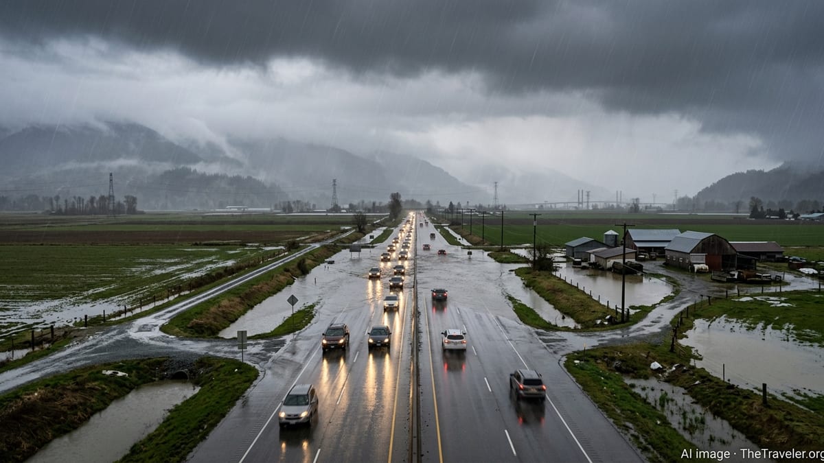
Dangerous flood warnings remain in effect across parts of Missouri, Kansas and Oklahoma after a volatile weekend of severe storms sent rivers and creeks surging above their banks, disrupting road travel and complicating early summer plans for residents and visitors across the central United States.
Get the latest news straight to your inbox!
Rivers Running High After Weekend Deluge
Publicly available alert data and river gauges show a broad swath of the central Plains still dealing with elevated waterways on June 16, with flood warnings extending into the start of the new week. Successive rounds of thunderstorms over the weekend dropped heavy rainfall on already saturated ground, pushing several rivers in Missouri, Kansas and Oklahoma to minor and, in some locations, moderate flood stage.
In Missouri, alerts compiled from National Weather Service products indicate continued flood warnings along portions of rivers such as the Blackwater, Marais des Cygnes and other tributaries feeding the Missouri River corridor. Some gauges have recorded crests at or above moderate flood thresholds, with water levels expected to slowly recede only late Monday into Tuesday if additional heavy rainfall does not materialize.
Kansas has seen similar impacts, particularly in the southeast, where monitoring tools highlight elevated flows on the Neosho River and other basins that collect runoff from recent storms. Travel routes near low-lying crossings and smaller county roads have been especially susceptible to closures as water spreads into adjacent fields and overtop rural bridges.
Downstream in Oklahoma, river forecasts show continued rises and prolonged high water on select tributaries that drain toward the Arkansas and Red River systems. While some gauges are projected to crest and begin a slow fall, the combination of residual runoff and saturated soils keeps the flood threat in place for communities along vulnerable stretches.
Travel Disruptions and Hazardous Road Conditions
The lingering flood warnings are having a direct impact on ground transportation across the three-state region. Local media reports describe numerous low water crossings barricaded, with law enforcement and emergency management offices urging drivers to avoid flooded roads and to anticipate detours on both rural routes and some secondary highways.
Many of the hardest-hit locations are away from interstate corridors, creating particular challenges for travelers relying on navigation apps that may not immediately reflect closures on county and township roads. Visitors heading to lakes, campgrounds or small-town events can encounter unexpected water over the pavement, washed-out shoulders and debris including tree limbs and gravel displaced by fast-moving runoff.
Bus operators, delivery services and regional carriers are also feeling the effects, with route planners forced to build in extra time around river valleys and low-lying stretches. For travelers passing through Missouri, Kansas and Oklahoma, the evolving pattern of closures means checking conditions multiple times per day rather than relying on a single pre-trip review.
Aviation and rail corridors appear to be less affected, although some regional airports report soggy fields and localized standing water near access roads and parking lots. In a few locations, rail lines that follow river bottoms have been monitored for potential washouts or track instability where water remains close to the right-of-way.
Impact on Outdoor Recreation and Summer Tourism
The early summer flood threat is reshaping recreational plans at a time when many travelers head to rivers and lakes for floating, fishing and camping. Publicly available park and reservoir updates in Missouri and Kansas point to high inflows, fast currents and, in some cases, partial closures of river access points, campgrounds and boat ramps.
For paddlers and anglers, the combination of elevated flows and debris-choked channels has created hazardous conditions on popular stretches of river. Outfitters and guide services in affected areas are adjusting schedules, steering customers away from swollen tributaries and, in some cases, temporarily suspending trips where currents are too swift or riverbanks are unstable.
State parks and recreation areas along flood-prone rivers in Oklahoma have reported inundated picnic areas, flooded trails and limited access to low-lying campsites. Travelers arriving with reservations may find that facilities closest to the water are closed for safety or undergoing cleanup from earlier high water, even if main camp loops and cabins remain open.
Lake-based tourism may fare somewhat better where flood-control reservoirs are capturing excess runoff, but beaches, fishing docks and marinas can still be affected by fluctuating levels and floating debris. Visitors planning boating or swimming are encouraged, through official bulletins and local news coverage, to monitor changing lake conditions as inflows from upstream rivers work their way into major impoundments.
Forecast Trends Keep Flood Threat Elevated
Short-term weather outlooks for the central Plains point to a pattern that, while less intense than the weekend storms, still includes the risk of additional showers and thunderstorms. Even modest rainfall totals over the next 24 to 48 hours could prolong existing flood warnings where rivers are already running high and levees and banks are under strain.
Hydrologic forecasts show that some gauges in Missouri, Kansas and Oklahoma may hover near flood stage through at least late Monday, with crests staggered downstream as high water moves along interconnected river systems. Locations that have not yet experienced significant flooding could still see rising water as runoff from upstream basins works its way through.
Publicly available analysis from river forecast centers notes that the flood risk is not uniform across the region. While certain mainstem rivers remain below critical thresholds, smaller tributaries and local creeks can respond quickly to any new downpours. This uneven pattern means that travelers may encounter calm conditions in one county and significant flooding in the next.
The timing of any additional storms will be especially important for communities that have already endured multiple rounds of severe weather. Evening and overnight rainfall can limit visibility for drivers and make it harder to recognize flooded segments of roadway in time to turn around, increasing the potential danger for those on the move after dark.
Guidance for Residents and Travelers
Emergency management advisories and travel updates emphasize a familiar but critical message: avoid driving into floodwater and remain prepared for rapidly changing conditions. Even shallow water can hide pavement damage or strong currents, and vehicles can lose traction or be swept off the road much more quickly than many drivers expect.
Residents in low-lying areas of Missouri, Kansas and Oklahoma are encouraged, through publicly distributed guidance, to keep an eye on local river gauges, media reports and official alert feeds, particularly where overnight rises are possible. Those in flood-prone neighborhoods should review evacuation routes, confirm they have fuel and supplies on hand and move valuables out of basements or ground-level storage.
For travelers, flexibility is key. It may be necessary to reroute around river valleys, shift arrival times to daylight hours or choose lodging on higher ground away from creeks and small rivers that can swell quickly. Keeping a paper map or offline navigation option can help when remote areas lose mobile data coverage during storms.
As the week progresses, improving conditions on some rivers should gradually reduce the number of active warnings, but lingering high water and soft ground will keep certain areas vulnerable. Anyone planning trips through Missouri, Kansas or Oklahoma in the coming days is advised, through a range of public information channels, to build extra time into itineraries and stay alert to updated flood statements and road reports.