
Perched on a narrow rocky outcrop high on the Tennessee–North Carolina border, Charlies Bunion is one of the most talked about viewpoints in Great Smoky Mountains National Park. Hikers swap stories about its drop off views and airy perch along the Appalachian Trail, but first time visitors often ask a simple question: how far is Charlies Bunion, really, and what will the hike feel like in practice? This guide breaks down the distance, difficulty, and on trail experience so you know exactly what to expect before you lace up your boots.
Get the latest updates straight to your inbox!
How Far Is Charlies Bunion From Newfound Gap?
The classic day hike to Charlies Bunion begins at Newfound Gap Overlook on Newfound Gap Road, the main highway that crosses Great Smoky Mountains National Park between Gatlinburg, Tennessee, and Cherokee, North Carolina. From the edge of the parking lot, you step directly onto the white blazed Appalachian Trail and follow it northeast along the state line. The National Park Service lists the trip at about 8 miles round trip, while several popular trail guides and local outfitters describe it as 8 to 8.1 miles out and back. That means you should think in terms of a 4 mile hike each way from Newfound Gap to the rocky viewpoint.
In addition to distance, elevation gain matters for how the route will feel. Expect roughly 1,600 to 1,650 feet of total ascent over the course of the hike, spread across a series of moderate climbs and descents rather than one unbroken uphill slog. The high point of the route is over 6,000 feet near the Icewater Spring Shelter area, while Charlies Bunion itself sits around the mid 5,000 foot mark in elevation. For many hikers who are used to trails at lower elevations near cities like Atlanta or Nashville, that combination of thinner air and repeated ups and downs can make the hike feel more strenuous than the numbers suggest.
In real world terms, reasonably fit day hikers typically spend about 4 to 6 hours completing the outing, including time for breaks and photos. For example, a visitor staying in Gatlinburg might leave town around 8 am, drive the 30 to 40 minutes up Newfound Gap Road, start hiking by 9 am, reach Charlies Bunion around 11:15, enjoy a half hour lunch on the rocks, and still be back at the car by mid afternoon with plenty of daylight to drive back down to town for dinner. Slower paces and longer breaks can easily push the total time toward the upper end of that 6 hour window.
Getting to the Trailhead and Parking Logistics
Newfound Gap Overlook is a destination in its own right, with a large paved parking area, stone walls framing big mountain vistas, and seasonal restrooms maintained by the park service. From downtown Gatlinburg, the drive to Newfound Gap is roughly 13 miles along US 441, usually taking 30 to 40 minutes depending on traffic and photo stops at overlooks. From Cherokee, North Carolina, on the south side of the park, you can plan on a similar drive time up the opposite side of Newfound Gap Road.
Although the lot at Newfound Gap is fairly large compared with many Smokies trailheads, it sees heavy use. Sightseers hop out for five minute photos at the state line sign, while day hikers head to destinations like Charlies Bunion or the Icewater Spring Shelter. On busy weekends in October leaf season or during peak summer vacation weeks, spaces can fill by late morning. The good news is that turnover is constant because so many visitors are only stopping briefly. In practice, arriving before 9 am often makes parking easy, even on crowded days, while an arrival around midday might mean circling for a few minutes until someone pulls out.
There is no separate parking fee at Newfound Gap beyond the park’s general parking tag requirement, which applies throughout the main areas of Great Smoky Mountains National Park. Travelers driving rental cars from Knoxville or Asheville can pick up a daily or weekly tag at entrance area kiosks, visitor centers such as Sugarlands near Gatlinburg, or through local outfitters in town that bundle tags with gear rentals. Having your tag displayed on the dashboard before you head up Newfound Gap Road avoids surprises and saves you from having to double back.
Trail Character: What the Hike Feels Like Underfoot
The entire route to Charlies Bunion follows the Appalachian Trail, which in this section runs along a high ridge that forms the Tennessee–North Carolina border. From the first steps leaving Newfound Gap, you are walking on a well defined path maintained for long distance backpackers as well as day hikers. The tread is a mix of packed dirt, roots, and rock, with built in stone steps on steeper pitches. Most of the time, the trail is wide enough for two people to pass each other without difficulty, though there are short narrow stretches where you will step to the side and let others by.
The grade is rarely extreme, but it is rarely flat for long either. Over the first couple of miles you will climb steadily through high elevation hardwoods and spruce fir forest, gaining views through the trees as you leave the parking lot far below. The air often feels cooler and damper here than down in Gatlinburg or Cherokee, especially in spring and early summer when clouds fill the valleys. A typical mid May morning might see temperatures in the 50s at Newfound Gap while it is in the 60s or low 70s in town, so many hikers begin with a light fleece or windbreaker before shedding layers as they warm up.
As you continue along the ridge, the path rolls over small knobs and saddles, with occasional sections of rockier footing that require more attention, especially after rain. Water bars and stonework in high use areas make the trail more durable but also add irregular steps that can be tough on knees during the descent. Trail runners or supportive hiking shoes work well for most visitors, but those with sensitive ankles often prefer mid height boots for the extra protection on these uneven surfaces. Trekking poles are a common sight too, particularly among older hikers and those carrying larger daypacks with camera gear.
Scenery and Landmarks Along the Way
One of the advantages of the Charlies Bunion hike is that it feels rewarding long before you reach the final viewpoint. Several miles of the Appalachian Trail here run near or along the crest of the ridge, with frequent glimpses into deep, forested valleys on both sides. On clear days you can look south toward the high country around Clingmans Dome and north toward the rolling hills that lead down to Gatlinburg and the Tennessee foothills. In spring, the forest floor erupts with wildflowers, including trillium and spring beauties, while in late June and early July, flame azalea and mountain laurel bloom along the trail.
A notable mid route landmark is the Icewater Spring Shelter, a backcountry shelter used by Appalachian Trail thru hikers and overnight backpackers. Even if you are just out for the day, the short side path to the shelter makes a good rest stop and an interesting peek into long distance hiking culture. You may see thru hikers cooking with compact stoves, drying socks, or checking paperback guidebooks, while chipmunks dash around looking for stray crumbs. The nearby piped spring serves as a reliable water source for backpackers, though day hikers typically carry their own water rather than stopping to filter here.
Beyond Icewater Spring, the forest begins to open more often, with stretches of trail that feel airy and occasionally exposed. In late autumn or winter when the leaves are down, the mountain silhouettes on both sides of the ridge become even more dramatic. On humid summer afternoons, you might watch storms building over distant peaks, a reminder of why rangers suggest early starts during thunderstorm season. Roughly four miles from Newfound Gap, the signed spur path to Charlies Bunion appears on the right, dropping slightly to the rocky outcrop itself.
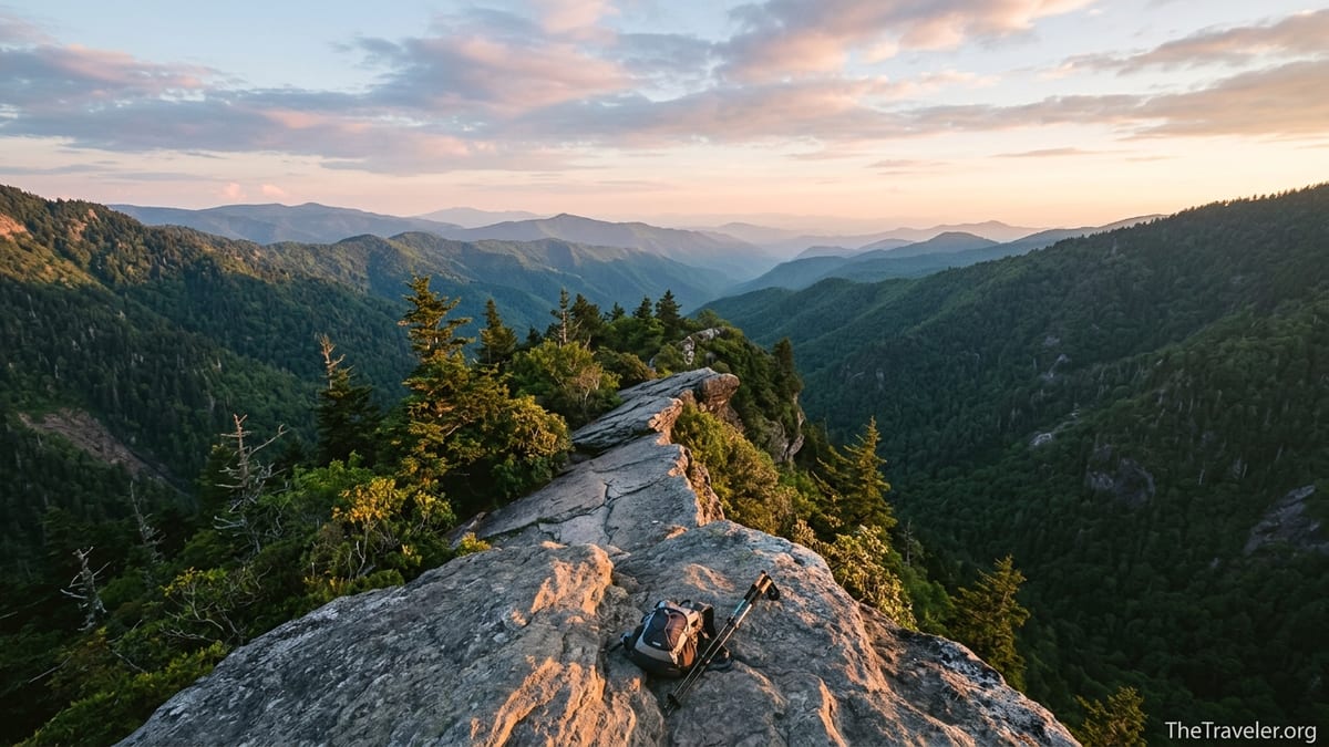
The Final Approach and Experience at Charlies Bunion
The side trail to Charlies Bunion is short but memorable. After leaving the main Appalachian Trail, you descend over broken rock and roots, weaving around scrubby vegetation and low conifers. The drop offs on either side become more apparent as you near the outcrop, and the path narrows to single file in places. Those with a strong fear of heights may feel their heart rate pick up, but most hikers find that stepping carefully, watching their footing, and taking their time keeps the traverse comfortable.
At the viewpoint, the rock narrows into a ledge that juts out into space, overlooking deep, forested drainages and a sweep of ridges that fade into the blue hazy distance characteristic of the Smokies. On popular days, hikers often take turns stepping out onto the very tip of the bunion for photos, then retreat to slightly more sheltered ledges set back from the edge for snacks or lunch. It is common to see people perched quietly, boots off, sharing trail mix or sandwiches bought that morning in Gatlinburg or Cherokee, cameras resting on their knees as they simply sit with the view.
Wind can be surprisingly strong here, even when the forested portions of the hike felt calm. A sun hat that stayed put all morning might need a chin strap at the viewpoint, and loose items like maps or lightweight jackets can blow off quickly if left unattended. Temperatures can also feel significantly cooler than in town, especially in shoulder seasons. Many hikers who set out in T shirts on a mild April or October day are glad to pull on a light puffy or windbreaker while they linger on the rocks.
Difficulty, Safety Considerations, and Who This Hike Suits
Most guidebooks and local hiking websites rate Charlies Bunion as a moderate to strenuous day hike. The distance of about 8 miles combined with roughly 1,600 feet of gain places it above short family strolls like Laurel Falls but below all day epics such as Mount Le Conte via Alum Cave in terms of effort. For a traveler who regularly walks a few miles at home and has done at least one or two half day hikes in hilly terrain, Charlies Bunion usually feels like a solid but manageable challenge. Less experienced hikers or those not accustomed to sustained elevation changes may find the final miles of the return leg especially tiring.
Safety wise, the principal concerns are weather, footing, and the exposure near the viewpoint. Summer brings common afternoon thunderstorms to the Smokies, and the high ridge that the Appalachian Trail follows is not an ideal place to be during lightning. Starting your hike earlier, checking the day’s forecast at a visitor center or through a trusted weather source, and turning around if skies darken are all prudent choices. In winter and early spring, snow and ice can linger on shaded sections of the trail, particularly between Newfound Gap and Icewater Spring, turning roots and rocks into hidden hazards. Lightweight traction devices that slip over boots can be useful in those conditions.
Children who are experienced hikers often do well on this route, but adults should closely supervise them near the bunion itself, where steep drop offs leave little margin for error. Dogs are not allowed on most trails in Great Smoky Mountains National Park, including this section of the Appalachian Trail, so pet owners should plan for kennel care in Gatlinburg or Cherokee if they want to tackle Charlies Bunion. Cell service is intermittent along much of the route, though some ridgeline stretches receive a weak signal, so relying on your phone alone for navigation is not recommended. A simple paper map of the central Smokies available at visitor centers offers plenty of backup assurance.
Planning Essentials: Gear, Food, and Timing
For most visitors, Charlies Bunion fits neatly into a half day or slightly longer hiking window. A common strategy is to book lodging in Gatlinburg, Pigeon Forge, or Cherokee, eat an early breakfast in town, and arrive at Newfound Gap by mid morning. That approach leaves ample time for a leisurely pace, scenic stops along the trail, and a relaxed lunch at the viewpoint. In the hotter months, an even earlier start can keep most of your effort in the cooler hours of the day and reduce the chance of being on the ridge during afternoon thunderstorms.
In terms of gear, treat Charlies Bunion as a true mountain hike rather than a casual stroll. Sturdy footwear with good traction, whether trail runners or hiking boots, makes the repeated climbs and rocky sections more comfortable. At least 1.5 to 2 liters of water per person is a reasonable baseline for most seasons, with more needed on hot or humid summer days. Many visitors stop at a grocery store in Gatlinburg or Cherokee to pack simple trail lunches like sandwiches, nuts, and fruit. A lightweight rain jacket or shell, a warm layer such as a fleece, and a brimmed hat can all prove useful given how quickly conditions can change at 5,000 to 6,000 feet.
Navigation is straightforward because you are following the well signed Appalachian Trail out and back, but carrying a simple Smokies trail map helps you contextualize the landscape and identify peaks and side trails as you go. Small extras such as sunscreen, insect repellent in warmer months, a basic first aid kit, and a headlamp or small flashlight round out a smart day hike kit. Travelers who do not own their own gear can rent trekking poles, daypacks, and sometimes even footwear from outdoor shops in Gatlinburg or Cherokee, where staff are often familiar with Charlies Bunion and can provide up to date anecdotal reports about current trail conditions.
Seasonal Differences and When to Go
Charlies Bunion is hikeable in all seasons, but the experience varies dramatically through the year. In spring, typically from April into early June, temperatures on the high ridge are cool, wildflowers line portions of the trail, and snow and ice gradually retreat from shaded slopes. Many hikers consider late April and May to be a sweet spot, when crowds are moderate compared with summer and fall, yet the forest feels freshly green. However, early spring storms can still drop snow at higher elevations, so checking recent conditions at a visitor center before committing to the hike is wise.
Summer brings lush foliage, warmer temperatures, and the longest daylight hours. Daytime highs at 5,000 to 6,000 feet are often significantly cooler than in low lying cities, which makes Charlies Bunion an attractive escape for visitors from places like Atlanta, Charlotte, or Knoxville looking to beat the heat. Afternoon thunderstorms are more likely, and humidity can make the climbs feel heavier, but an early morning start and steady hydration usually keep things comfortable. Insect activity is present but generally not oppressive compared with lower elevation swampy areas of the Southeast.
Autumn, especially from late September through late October, is peak season for many Smokies visitors. Cooler air, drier skies, and colorful foliage draw crowds to Newfound Gap Road. Views from Charlies Bunion can be spectacular when ridges glow with reds and golds, but trailhead parking is also at its busiest, which makes early starts and weekday hikes particularly valuable. Winter turns the high ridges into a quieter and often more severe environment. Snow and rime ice can transform the trail into a beautiful but serious undertaking, appropriate only for well prepared hikers with warm layers, traction devices, and a realistic understanding that Newfound Gap Road sometimes closes temporarily due to weather.
The Takeaway
For many visitors, Charlies Bunion is the quintessential Smokies day hike: a solid 8 mile round trip effort that rewards persistence with sweeping mountain views and the chance to walk a storied section of the Appalachian Trail. The distance from Newfound Gap is significant but not extreme, the elevation gain adds up without ever feeling relentlessly steep, and the scenery along the way makes the hours pass quickly. With thoughtful planning, realistic expectations about fitness and conditions, and a bit of respect for the exposure at the viewpoint, this route can be a highlight of a Smokies trip rather than a white knuckle surprise.
If you imagine yourself setting out from the stone walls of Newfound Gap Overlook, climbing through cool spruce fir forest, pausing at Icewater Spring to watch thru hikers filter water, then stepping carefully onto a rocky perch high above the valleys, you already have a good sense of what awaits. Charlies Bunion is not just a name on a map but a tangible experience in the high country of Great Smoky Mountains National Park. Understanding how far it is, what the trail feels like, and how to prepare means you can focus less on logistics and more on the simple joy of walking through one of America’s most beloved mountain landscapes.
FAQ
Q1. How far is Charlies Bunion from Newfound Gap? The standard route from Newfound Gap Overlook to Charlies Bunion is about 8 to 8.1 miles round trip, or roughly 4 miles each way along the Appalachian Trail.
Q2. How long does it take to hike to Charlies Bunion and back? Most reasonably fit hikers take between 4 and 6 hours to complete the hike, including rest stops and time spent enjoying the view at the rocky outcrop.
Q3. Is the Charlies Bunion trail considered difficult? The hike is usually rated moderate to strenuous due to its 8 mile length and roughly 1,600 feet of total elevation gain, plus some rocky and uneven sections underfoot.
Q4. Can children hike to Charlies Bunion? Many experienced young hikers complete this route, but adults should carefully assess each child’s stamina and closely supervise them near the exposed viewpoint where drop offs are significant.
Q5. Are dogs allowed on the Charlies Bunion trail? No. Dogs are not permitted on most trails in Great Smoky Mountains National Park, including this section of the Appalachian Trail between Newfound Gap and Charlies Bunion.
Q6. Do I need any special permits or reservations for this hike? You do not need a backcountry permit for a simple day hike, but you will need a valid parking tag for your vehicle in Great Smoky Mountains National Park, which can be purchased before you drive up Newfound Gap Road.
Q7. What is the best time of year to hike to Charlies Bunion? Late spring and autumn are especially popular for cooler temperatures and scenic views, but many hikers also enjoy summer for its long days and lush greenery, provided they start early to avoid afternoon storms.
Q8. Is the trail to Charlies Bunion exposed or dangerous? Most of the hike runs through forest along a well defined ridge trail, but the final outcrop at Charlies Bunion has significant exposure and steep drop offs, so careful footing and keeping back from the very edge are important.
Q9. Can I get water along the way, or should I carry it all? Backpackers use Icewater Spring near the shelter to filter water, but day hikers are generally advised to carry all the water they need, typically at least 1.5 to 2 liters per person in moderate conditions.
Q10. Is Charlies Bunion suitable for a first hike in the Smokies? It can be a great choice for a first serious Smokies hike if you already have some basic hiking experience, are prepared for an 8 mile day with hills, and start early with proper gear and realistic expectations about the effort involved.