
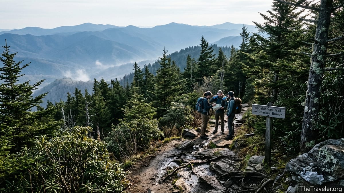
On paper, Charlies Bunion looks straightforward: roughly 8 miles round trip along the famous Appalachian Trail from busy Newfound Gap, a marquee viewpoint in Great Smoky Mountains National Park. It is one of the park’s most talked-about day hikes, recommended in guidebooks, social media posts, and visitor center brochures. Yet every year, rangers respond to exhausted, injured, or dangerously underprepared hikers somewhere between Newfound Gap and that rocky outcrop. The common thread is rarely a freak storm or a wild animal encounter. The biggest mistake happens long before any boots hit the dirt: people underestimate what Charlies Bunion really is.
Get the latest updates straight to your inbox!
Misjudging a Scenic Stroll for a Serious Mountain Hike
The defining error most hikers make before attempting Charlies Bunion is treating it like a casual overlook walk rather than a sustained mountain hike at altitude. The parking lot at Newfound Gap is packed with families in flip-flops taking selfies at the Tennessee–North Carolina state line. From there, the Appalachian Trail looks civilized and well groomed, and the first half-mile rolls gently through spruce fir forest. It is easy to assume you are heading out on an extended version of a roadside viewpoint trail.
In reality, Charlies Bunion is an approximately 8-mile out-and-back with roughly 1,500 to 2,000 feet of cumulative elevation gain at over 5,000 feet above sea level for much of the route. The National Park Service classifies the outing as a strenuous day hike, not a short viewpoint stroll. The trail surface is often rocky and rooty, with short but sharp climbs and descents that feel different from lowland walks of the same distance. Visitors who are comfortable on flat greenway paths near Gatlinburg are often surprised by how much effort it takes to maintain a steady pace here.
Stories from the trail illustrate this gap between expectation and reality. It is common to meet visitors who started late morning in running shoes with a single small water bottle because a blog post or social feed made Charlies Bunion look easy. By the time they reach landmarks like Icewater Spring Shelter, some are already questioning whether to push on. Others do push on, only to limp back in the afternoon heat, dehydrated and with sore knees from the constant downhills. The hike has not changed; their expectations have.
That misjudgment has wider consequences in a park that logs dozens of search and rescue calls in a typical season. Regional incident summaries often note hikers who underestimated the distance and difficulty of Smokies trails, including high ridgeline routes like the one to Charlies Bunion. For rangers, an “easy viewpoint hike” undertaken with city-park habits is a familiar prelude to twisted ankles, exhaustion, and late-night evacuations.
Trail Reality: Distance, Elevation, and Technical Footing
The numbers behind Charlies Bunion help explain why treating it casually is such a problem. From Newfound Gap, the Appalachian Trail rolls and climbs roughly 4 miles each way to the rocky promontory. Map and guide sources vary on exact elevation gain, but many put total ascent in the 1,500-foot range when you account for repeated ups and downs along the ridge. At these elevations, the thinner, cooler air also affects how hard your body works, especially if you are visiting from lower, hotter regions.
Trail condition is another factor that gets glossed over in simple distance summaries. The route traverses sections of eroded tread, slick rock, and root-strewn corridors that stay damp for long stretches, especially after rain or during shoulder seasons. Hikers often mention that the Smokies feel “harder than the stats” because of this combination of uneven footing and constant little climbs. The park’s own safety guidance emphasizes that slips, trips, and falls are among the most common causes of injury, especially where roots and rocks are hidden by leaves or light snow.
Once you approach Charlies Bunion itself, the stakes rise. The outcrop is surrounded by steep drop-offs, and while the use path out to the viewpoint is obvious, it narrows near the edge. Smokies-focused hiking sites and local outfitters regularly caution visitors to move carefully here, especially if the rock is wet or crowded. Parents with children and photographers stepping backward for the perfect shot are particularly vulnerable when they have not mentally shifted from “roadside overlook mode” to “cliff environment” thinking.
Even before you reach the namesake outcrop, there are commitment points that catch unprepared hikers off guard. Around 2.7 miles in, a junction leads toward The Boulevard and other high-country routes, and around the 3-mile mark you reach Icewater Spring Shelter, a busy waypoint used by backpackers. Many day hikers mistakenly treat this as a halfway rest stop on a leisurely ramble, not realizing they still face more climbing and another mile or so to the actual viewpoint, followed by the full return leg back to Newfound Gap.
Underestimating Weather and Seasonal Hazards on the Ridge
Another dimension of underestimation plays out in the sky above Charlies Bunion. Newfound Gap sits above 5,000 feet, and the ridge-top trail to the Bunion is often 10 to 20 degrees cooler than lower-elevation gateways like Gatlinburg or Cherokee. The National Park Service urges visitors to anticipate sudden weather changes on high-elevation trails, noting that cool, wet, and windy conditions can prompt hypothermia any time of year. Hikers who dress for a warm afternoon in town can find themselves shivering in cloud and mist within an hour of leaving the parking lot.
Real-world visitor reports underline how quickly conditions shift. In autumn, hikers describe starting under blue skies, only to encounter dense fog and strong winds near Icewater Spring Shelter, with the outcrop itself completely socked in. In winter, packed snow and ice frequently linger on the north-facing sections of the Appalachian Trail that lead to Charlies Bunion, even when Newfound Gap Road has been plowed and reopened. Without traction devices, the trip becomes a careful negotiation of icy slopes, and falls are common.
Summer brings a different set of risks that are easy to shrug off at the planning stage. Temperature and humidity can remain high even at ridge level, and thunderstorms build quickly in the afternoons. Park safety advisories stress that hikers should avoid ridgelines during lightning, seek lower ground, and be prepared to turn around if storms threaten. Yet it is not unusual to see visitors start up the trail late in the day, assuming that a couple of light showers will simply “cool things down” and not considering what a slick, exposed rock fin and saturated trail might mean on the descent.
If there is a pattern, it is this: people check the weather for Gatlinburg or Bryson City, glance out the hotel window, and pack as if they were walking a riverside path. The particular microclimate of a high Smokies ridge, with gusty winds, sudden cloud build-ups, and rapidly dropping temperatures, is something many do not fully factor in until they are already cold or drenched several miles from the car.
Going Light on Water, Food, and Basic Gear
Closely tied to underestimating the hike is a minimalist approach to supplies. Park safety messaging urges hikers to carry at least a liter of water for every two hours of hiking, plus snacks, a light insulating layer, and a flashlight or headlamp, even on day hikes. Yet on busy weekends it is common to see Charlies Bunion bound walkers with a single half-liter bottle in hand, no pack, and no rain layer, counting on the cool forest to keep them comfortable.
This is not just a theoretical concern. Smokies rangers frequently cite dehydration and exhaustion as contributing factors in search and rescue incidents. On an 8-mile ridgeline hike, especially for visitors not used to sustained climbs, it is realistic to spend 4 to 6 hours on the trail. If you start late and linger at viewpoints, you may still be hiking as light fades, particularly in spring and autumn when days are shorter.
There is one prominent water source along the route at Icewater Spring, where a pipe channeled from a high spring feeds a small flow across the trail. Some hikers treat this as a guaranteed refill, but backcountry guidance stresses that all surface water should be treated or filtered. Counting on a single spring as your hydration plan, without any purification method, is another expression of the “easy viewpoint” mindset. Experienced visitors often carry two reusable bottles or a hydration reservoir, plus a compact filter or treatment tablets, rather than assuming they can rely on one small source.
Food and extra clothing often get short shrift as well. A few snack bars in a jacket pocket might suffice on a quick overlook walk, but if you misjudge your pace on Charlies Bunion and find yourself moving slower over rocky sections, your energy reserves matter. Local outfitters routinely advise visitors to carry calorie-dense snacks like nuts, jerky, and trail mix, along with a light fleece or synthetic jacket and a rain shell that can handle wind and passing showers. A small headlamp, even one you rarely use, can be the difference between a careful twilight descent and a dangerous, phone-flashlight stumble after dark.
Ignoring Fitness, Timing, and Personal Limits
The most honest planning question for Charlies Bunion is not “How famous is this hike?” but “How does this hike match my current fitness and trail experience?” Many visitors base their decisions on reputation and online photos rather than on what their bodies are ready for. An 8-mile mountain hike feels very different from an 8-mile bike ride or urban walk, and that difference can catch up with people midway through the route, far from help.
Regional hiking organizations that review Smokies trails often emphasize that ridgeline hikes like Newfound Gap to Charlies Bunion land at the upper end of moderate or into strenuous territory for casual hikers. Guides recommend starting no later than mid-morning, ideally around 8 or 9 a.m., to allow generous time for breaks and for navigating crowds at the viewpoint. Many incident accounts, by contrast, involve hikers who began around midday, lingered at the Bunion, and underestimated how long the return trip would take. Fatigue on the way back can lead to slower reaction times, missteps on rock or root, and the kind of ankle or knee injuries that suddenly make every remaining mile feel twice as long.
There are real rescue stories behind these cautionary points. In recent seasons, local news outlets have documented multiple evacuations of hikers deep in the Smokies backcountry, sometimes more than 10 miles from trailheads, after leg injuries or exhaustion left them unable to continue. While not all of these incidents occurred on the Charlies Bunion route, the pattern is clear: underestimated distance plus limited daylight and marginal fitness equals a high likelihood of trouble, especially in rugged terrain.
For visitors used to lower-elevation hikes, one of the best reality checks before attempting Charlies Bunion is to sample a shorter Smokies trail with some elevation gain, such as a 3 to 4 mile waterfall hike or a loop near one of the visitor centers. If that outing leaves you thoroughly spent, consider postponing Charlies Bunion for another trip or treating it as a training goal rather than a must-do in a tight itinerary.
Crowds, Parking, and the Pressure to Push On
There is another, subtler way hikers underestimate Charlies Bunion: they overlook how crowds and logistics will shape their decision-making. Newfound Gap is one of the busiest viewpoints in Great Smoky Mountains National Park. On peak weekends and holidays, drivers circle the lot waiting for spaces, and a long line of hikers funnels onto the Appalachian Trail. After investing time and effort to find parking and get underway, many feel pressure to “get their money’s worth” and reach the famous rock, even if conditions deteriorate or they start feeling pushed beyond their comfort zone.
Trail reports show that congestion can be significant at narrow sections and at the Bunion itself, with people waiting for turns on the best photo perches. That crowd energy can mask your own fatigue or hesitation. When everyone else seems to be pressing on, it becomes harder to listen to the quiet internal signals that say, “This is far enough for today.” Yet one of the core safety messages from the park is the importance of turning around when conditions, time, or personal limits call for it, no matter how close a destination might appear on the map.
Parking stress can also push people into questionable timing. Arriving at Newfound Gap late in the morning during a busy period, some hikers only find a spot around lunchtime. They see others heading onto the Appalachian Trail and decide to follow, assuming that if the lot is still full, it must be “fine” to start late. They may not factor in that strong local hikers and thru-hikers are also using this lot for much longer routes, or that some people on the trail have turned around earlier or started at dawn.
Planning for Charlies Bunion means planning for logistics as much as for distance. Aim to arrive early enough that you are not starting under pressure, and build a clear turnaround time into your day. If you reach that time before you reach the Bunion, consider a closer viewpoint or rest spot your personal destination. The vistas from along the ridge are beautiful in their own right, and the confidence of knowing when to turn back is a hallmark of experienced mountain travelers.
How to Reframe Charlies Bunion and Prepare Properly
Avoiding the classic mistake with Charlies Bunion is more about mindset than about buying expensive gear. The key is to reframe the outing from “tourist must-do” to “serious day hike in high mountains.” Once you see it that way, your planning decisions shift naturally. You are more likely to check a detailed topographic map or a reputable guide description, notice the cumulative elevation gain, and pack accordingly.
In practical terms, proper preparation means treating Charlies Bunion like any major day hike in a national park. Wear sturdy hiking shoes or boots with good traction, not sandals or casual sneakers. Carry sufficient water for at least 4 to 6 hours on trail, along with calorie-dense snacks and a system to treat additional water if needed. Include a light insulating layer, a waterproof or water-resistant shell, a basic first-aid kit, and a headlamp. In colder months, traction devices that fit over your footwear can turn an icy risk into a manageable walk.
If you normally hike only a few miles on flat ground, consider building up with shorter local trails before your trip, or choose a less demanding Smokies viewpoint such as Clingmans Dome’s short, steep paved path or an overlook drive. When planning your day, set a conservative turnaround time based on the earliest sunset you could reasonably encounter during your visit, and check the forecast for high-elevation zones rather than just for nearby towns. If thunderstorms or heavy fog are in the cards, be ready to pivot to a lower, safer trail.
Most of all, adopt the attitude that reaching the Bunion is optional, while returning to the trailhead safely is non-negotiable. Some hikers end their day at Icewater Spring Shelter, enjoying sweeping views from nearby clearings and calling it a victory. Others make it only halfway before deciding to turn back, then later describe the outing as one of the highlights of their trip because they moved at a comfortable pace and stayed fully present to the forest, clouds, and ridgeline vistas.
The Takeaway
Charlies Bunion is a deservedly iconic hike in Great Smoky Mountains National Park: a ridge-top walk on the Appalachian Trail to a dramatic rock outcrop with far-reaching views. What it is not, despite how it can appear in quick online snapshots or crowded trailhead scenes, is a casual stroll suitable for anyone in any footwear at any time of day. The biggest mistake hikers make is underestimating the demands and special conditions of this high-elevation route and failing to prepare as they would for any serious mountain outing.
By recognizing Charlies Bunion as a strenuous day hike, you give yourself permission to slow down, carry the essentials, and say no when the weather, the time, or your own body suggests turning back. You also free yourself to appreciate the journey instead of treating the rock outcrop as a box to be checked. With realistic expectations, adequate gear, and a flexible mindset, Charlies Bunion becomes less a test to be survived and more a memorable encounter with the Smokies’ rugged spine.
The park’s rangers like to remind visitors that rescue is never guaranteed, and that backcountry travel is undertaken at your own risk. When you resist the urge to underestimate this hike, you honor that responsibility and stack the odds heavily in your favor. In doing so, you give Charlies Bunion what it deserves: not fear or bravado, but respectful preparation and the simple satisfaction of a day well spent on one of the park’s classic trails.
FAQ
Q1. How long does it take to hike to Charlies Bunion and back?
Most day hikers should plan on 4 to 6 hours for the roughly 8-mile round trip, depending on fitness, pace, trail conditions, and how long you linger at viewpoints.
Q2. Is Charlies Bunion suitable for beginners?
It can be manageable for fit beginners with some hiking experience, but it is not ideal as a first-ever mountain hike. Less experienced visitors may want to start with shorter trails that have moderate elevation gain before attempting it.
Q3. What is the elevation gain on the Charlies Bunion hike?
The route includes approximately 1,500 feet of cumulative elevation gain, with a series of climbs and descents along the ridge that make it feel more strenuous than a flat hike of the same distance.
Q4. Do I need special gear for Charlies Bunion?
You do not need technical climbing gear, but sturdy hiking shoes or boots, at least 2 liters of water, snacks, a light jacket, a rain shell, and a headlamp are strongly recommended. In winter, traction devices for icy sections are very helpful.
Q5. Is there water available on the trail?
There is a spring near Icewater Spring Shelter where many hikers refill, but all backcountry water should be treated or filtered. Do not rely on this as your only water source; carry enough for the full hike.
Q6. How dangerous are the cliffs at Charlies Bunion?
The outcrop is surrounded by steep drop-offs, and the rock can be slick when wet or icy. Staying back from the edge, keeping children close, and moving carefully greatly reduce risk.
Q7. When is the best time of year to hike Charlies Bunion?
Late spring through early fall typically offers the most accessible conditions, though summer can be hot and stormy. Winter and early spring can bring snow and ice, which require extra preparation and traction.
Q8. Can I take children on the Charlies Bunion trail?
Many families do hike this trail with older children who are strong walkers and can follow safety instructions near drop-offs. For younger kids, the distance, elevation, and exposure at the viewpoint can be challenging.
Q9. What time should I start the hike?
Starting between 7 and 9 a.m. is ideal for most visitors. An early start helps you avoid crowds, reduce the chance of afternoon storms, and ensure you are off the ridge well before dark.
Q10. What should I do if the weather turns bad while I am on the trail?
If storms, high winds, or thick fog develop, consider turning back even if you have not reached Charlies Bunion. Prioritize getting safely back to the trailhead with enough daylight and energy rather than pushing on to the viewpoint.