


Sierra de Grazalema Natural Park is not a place where you can simply drive up, pick a famous trail and start walking. The park combines easily accessible riverside paths and village circuits with tightly regulated conservation areas, including the unique pinsapo fir forest and fragile limestone gorges. Planning a visit from Ronda means understanding where you are free to roam, where advance permits are compulsory and when certain routes are completely off limits to independent hikers.
Get the latest updates straight to your inbox!
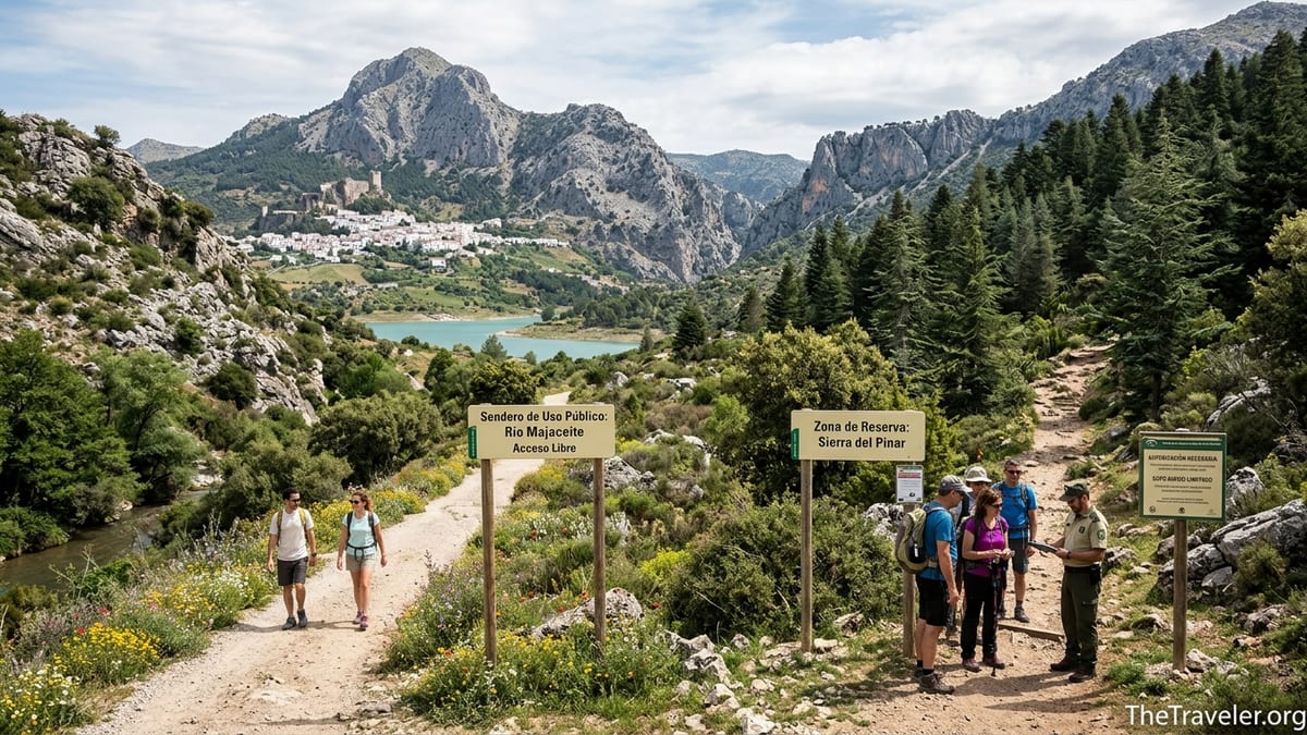
Understanding Restricted and Free-Access Areas
The 53,000-hectare Sierra de Grazalema Natural Park stretches between the province of Cádiz and the Serranía de Ronda, and its rules reflect how fragile this wet, karstic landscape is. Authorities distinguish between ordinary use areas where signposted paths are open without paperwork, and “zona de reserva” sectors such as the Sierra del Pinar, home to the rare Spanish fir forests and the Garganta Verde canyon, where access is limited to protect habitats and reduce fire risk.
For visitors starting in Ronda, the key implication is that the park’s most famous routes, including El Pinsapar, Garganta Verde and El Torreón, require advance authorization, controlled numbers and, in some seasons, guided groups only. You cannot rely on last-minute decisions or assume that showing up early will secure a place. By contrast, classic walks like the Río Majaceite between El Bosque and Benamahoma, short circuits above Grazalema village or the Llanos del Republicano from Villaluenga del Rosario can generally be walked independently without paperwork when conditions are normal.
Regulations are updated in the Junta de Andalucía’s public-use programme for the park. Recent versions confirm that access to the Sierra del Pinar reserve requires permission throughout the year, and that in summer the pinsapar sector faces extra fire-related restrictions. After heavy rain events, such as the storms that led to temporary spring closures in 2026, the Junta has also shown it will close popular trails or road sections at short notice due to landslides or rockfall, so even free-access paths should be checked locally before setting out.
Another practical distinction is that some names refer to broader zones rather than a single trail. “El Pinsapar” describes both the protected forest itself and the long traverse between Grazalema and Benamahoma, while “Garganta Verde” covers everything from a family-friendly viewpoint path to demanding descents involving scrambling and water. Understanding which specific route you are booking helps match expectations, fitness and equipment.
How the Official Permit System Works
Permits for restricted trails are managed through the Junta de Andalucía’s nature-visits system, coordinated by the regional environment agency. The process combines an online reservation platform with traditional contact through visitor centres such as the El Bosque Centro de Visitantes, which handles much of the day-to-day allocation for Grazalema’s reserve-area routes. Recent guidance also points to a central ecotourism portal and a helpline where staff can assist with bookings and accessibility questions.
At the time of writing, four main routes in Sierra de Grazalema require advance authorization: El Pinsapar, Garganta Verde, El Torreón and Llanos del Rabel. Quotas are limited to small groups per day, and permits are free but must be requested in advance, especially for weekends and spring or autumn holidays. Walkers report that applying a few weeks before a planned visit improves the chances of securing the date you want, and that shoulder-season midweek slots are the easiest to obtain.
The application typically involves selecting a specific trail and date, indicating group size and providing ID details for at least one responsible adult. Confirmation is usually sent by email, which you should save on your phone and, ideally, print. Rangers and environmental agents carry out spot checks at trailheads such as the Puerto de las Cumbres and the Garganta Verde access on the Zahara road, and have authority to turn back visitors who cannot show valid authorization or who arrive outside the permitted time window.
Closures are enforced in a similarly strict way. During periods of “alto riesgo de incendios,” which typically run from early June to mid-October, regulations prohibit non-essential vehicle access on many forest tracks and can suspend permits on particularly vulnerable routes. After heavy rainfall, the Junta has previously suspended visits to parts of the reserve due to unstable slopes. This means that even with a permit in hand, you should check the latest advisories with the park office or local tourist information in Ronda, Grazalema or Zahara the day before your hike.
El Pinsapar: Seasonal Rules and Practical Realities
El Pinsapar, the long traverse between Grazalema and Benamahoma across the north face of the Sierra del Pinar, is one of the flagship routes of the park and also one of the most regulated. Official documents for the public-use programme state that access to the pinsapar zone is always by authorization and that, from 1 June to 15 October, independent access to the central forest is effectively suspended for fire prevention. In this period, only defined educational or guided activities are allowed, and even these may be limited to the approach section between Grazalema and the start of the pinsapo forest before returning to the same trailhead.
Outside the high-risk fire season, roughly from mid-October to late May under recent practice, holders of a valid permit can usually complete the full 10 to 12 kilometre route between the Grazalema side and Benamahoma, crossing the Puerto de las Cumbres and traversing the cool, shaded fir forest. Walking time is generally estimated at 4 to 5 hours for fit hikers, with moderate to significant elevation gain and long stretches on uneven limestone. This is far removed from a riverside stroll and is best suited to walkers comfortable with full-day mountain routes.
The pinsapo forest itself lies in a steep, concave basin that acts like a catchment for Atlantic moisture. The area regularly records some of Spain’s highest annual rainfall totals, and the combination of wet clayey soils and exposed limestone can be surprisingly slippery even several days after rain. In winter, patches of snow or ice can linger in shaded gullies. Waterproof boots with good grip, layered clothing and trekking poles are strongly recommended, and rangers advise against entering the route without a proper forecast check, even if you have secured authorization weeks in advance.
For visitors based in Ronda, walking El Pinsapar as an out-and-back from Grazalema and then returning to Ronda by bus or car is realistic as a dedicated day if the route is open and you hold the necessary permit. Attempting to combine the full pinsapar traverse with long sightseeing stops in both Benamahoma and El Bosque on the same day, however, becomes logistically awkward, particularly if you are dependent on the limited bus departure times back toward Ronda.
Garganta Verde: Viewpoint Walk Versus Canyon Descent
Garganta Verde is another headline feature of Sierra de Grazalema, a narrow limestone canyon carved by the Bocaleones stream below Zahara de la Sierra and under the cliffs of Monte Cambronera. The park recognises a standard hiking route of around 2.5 to 3 kilometres each way from the Zahara road down to the interior of the gorge, classified as medium to high difficulty because of its steep, loose sections and the need to negotiate boulders and occasional pools. This route requires a permit throughout the year, and daily numbers are tightly capped to protect one of Europe’s larger breeding colonies of griffon vultures.
A crucial distinction for planners in Ronda is between the moderate hiking experience involved in following the official footpath to the main viewpoint or upper section of the gorge, and the much more demanding activities that descend further into the canyon bed or follow aquatic sections. The latter often involve scrambling, use of ropes in the lower slots and sometimes wetsuits and helmets when water levels are high. These canyoning-style trips are only appropriate with specialized guides and involve their own safety protocols and insurance requirements beyond the regular hiking permit.
For the standard Garganta Verde hiking permit, you apply through the same Junta system used for El Pinsapar, selecting the “sendero Garganta Verde” option. Holders are usually instructed to start within particular entry times to avoid congestion and to complete the route the same day, returning via the same path. Many visitors from Ronda combine the hike with an exploration of Zahara village, either before or after the walk, but it is important to factor in the steep drive up and down the CA-9104 mountain road and limited parking bays around the trailhead.
Fitness-wise, the viewpoint-level hike is still demanding due to the sustained descent and re-ascent on loose, sometimes muddy terrain. Anyone with knee issues, vertigo or limited balance should consider whether a shorter, less exposed walk might be preferable. Families with younger children often opt for village viewpoints around Zahara or panoramic roadside stops along the Puerto de las Palomas pass instead of committing to the full canyon entry and exit.
Freer Trails: Río Majaceite, Llanos del Republicano and Village Walks
Beyond the reserve-area routes, Sierra de Grazalema offers a network of signposted paths that do not normally require permits. One of the best known is the Río Majaceite walk linking El Bosque and Benamahoma along a lush riverside track. The route covers roughly 4 to 5 kilometres one way, with minimal cumulative ascent, and can be walked in about 1.5 to 2 hours at a relaxed pace. It is popular with families, and on warm days locals use small river pools for paddling, although swimming is not officially organized.
The main constraints on the Río Majaceite are seasonal water levels and storm damage. After severe rains, sections may be temporarily closed or detours signposted, and in high summer some stretches can feel humid and crowded. Dogs are required to be kept on a lead, and park guidelines emphasize leaving no litter and avoiding open flames along the river, which lies within the wider fire-risk management zone for the park.
Llanos del Republicano, near Villaluenga del Rosario, provides a different feel: a high, open karst plateau framed by cliffs and frequented by grazing cattle and goats. Typical circular walks here range across 8 to 12 kilometres, with moderate elevation gain but little technical terrain, and are generally considered suitable for experienced walkers who are comfortable navigating waymarked but occasionally faint paths on limestone. The area is often combined with visits to Benaocaz or to the dramatic Salto del Cabrero cliffs, another highlight mentioned in provincial tourism material for the park.
Around Grazalema village itself, several short routes start almost from the edge of the whitewashed streets. A commonly recommended example is the short climb to the Sagrado Corazón viewpoint, accessible from the A-372 road just before entering the settlement from El Bosque. This walk provides wide views over the red-tiled roofs and the surrounding peaks for significantly less effort than the major reserve-area hikes, and can be slotted easily into a half-day visit combined with café stops and handicraft shops in the village centre.
Reaching the Park from Ronda: Roads, Buses and Time Costs
Ronda functions as a rail and bus hub on the Malaga and Seville lines, but the last stretch into Sierra de Grazalema is always by road. Grazalema village lies to the northwest along the A-374 and A-372, with a driving time of roughly 45 to 55 minutes from central Ronda depending on traffic and weather. The road climbs steadily and includes multiple bends as it approaches the Puerto de las Palomas, so speeds are often lower than the distance on the map might suggest, especially after heavy rain or in fog.
Zahara de la Sierra is reached by following the A-374 and then cutting north onto local roads, a journey of about 45 minutes by car in good conditions according to regional tourism guides. El Bosque and Benamahoma lie further west along the A-372, generally taking around 1 hour 15 minutes by car from Ronda. Benaocaz and Villaluenga del Rosario sit higher up again, often requiring 1 hour 20 to 1 hour 30 minutes due to slower, twistier sections. For a driver used to mountain roads, these times are manageable, but visitors unused to tight bends should allow extra margins.
Public transport exists but is limited. Damas operates a bus line between Ronda and Grazalema which, as of spring 2026, was being partially restored with at least one or two services per day on weekdays and fewer at weekends, subject to advance seat reservation. Separate services by Transportes Comes connect Ronda and Zahara de la Sierra, with sample fares of around 5 to 6 euros one way and typical journey times of about 45 minutes according to recent timetables and booking platforms. Services between the smaller villages, such as Benaocaz, Villaluenga or Benamahoma, are far sparser, and many inn-to-inn walking itineraries resort to short taxi transfers to bridge gaps.
Because of these constraints, combining distant trailheads and several white villages in one day without a private vehicle is highly impractical. For example, a visitor attempting to leave Ronda by morning bus to Grazalema, complete a long hike such as El Pinsapar or El Torreón, transfer by taxi to Zahara for sunset at the castle and return to Ronda the same night would face an exhausting and uncertain schedule, with little margin for delayed buses, slow walking conditions or weather changes.
Even with a rental car, stacking two major hikes such as Garganta Verde and the full pinsapar traverse into a single day from Ronda would mean 3 to 4 hours of driving plus 7 to 9 hours of serious walking, much of it on steep limestone. For safety reasons, local guides and visitor centres usually advise focusing on one significant hike per day and using remaining time for lower-effort village visits or viewpoints rather than booking back-to-back strenuous routes.
Weather, Terrain and Safety: What Makes Grazalema Demanding
Sierra de Grazalema is known within Spain for exceptionally high rainfall, as moist Atlantic air masses are forced to rise over the limestone massifs. Annual totals around the Sierra del Pinar are often among the highest recorded in the country, which sustains the pinsapo fir forest but also contributes to frequent fog, slick rocks and sudden stream surges. Walkers arriving from the drier Costa del Sol can be surprised by how quickly conditions change, especially in autumn and winter.
Limestone terrain adds its own complications. Many paths cross sharp, irregular pavement or are covered in loose scree. When wet, these surfaces become extremely slippery, increasing the risk of falls. In canyon sectors like Garganta Verde, rock steps and boulders can remain damp even after days of sun due to shade and seepage. Good footwear, ideally with a Vibram-style sole or equivalent quality, is much more than a comfort choice; it is a critical safety factor.
Summer introduces different challenges. From June to September, midday temperatures on exposed ridges and south-facing slopes regularly reach levels that make strenuous hiking uncomfortable or risky, particularly for those unused to heat. Fire restrictions are strict, and authorities can close certain tracks entirely during heatwaves. Most local guides schedule early morning starts, finishing demanding ascents before midday and reserving afternoons for shaded riverside paths or village exploration rather than high ridges.
Water sources are another concern. While routes like the Río Majaceite stay close to flowing water, many of the reserve-area hikes and plateau walks have no reliable springs along the way. Visitor centres typically advise carrying at least 1.5 to 2 litres per person for moderate half-day hikes and more for full-day mountain routes, along with sun protection and basic emergency supplies. Mobile phone coverage is patchy in deep valleys and behind major ridges, further reinforcing the need for conservative route planning.
Three Realistic Day Excursions from Ronda
An easy village-and-viewpoint day for less experienced walkers starts with a mid-morning drive or bus ride from Ronda to Grazalema, allowing around one hour for the journey. After a coffee in the main square, you could walk the short signed path to the Sagrado Corazón viewpoint above the village, gaining broad panoramas without entering restricted zones. After lunch, a leisurely drive over the Puerto de las Palomas pass toward Zahara de la Sierra provides spectacular roadside viewpoints, with brief stops at official miradores to photograph the turquoise reservoir and the white village perched on its ridge.
A moderate marked-trail day could focus on the Río Majaceite. From Ronda, drive to El Bosque, park near the signed trailhead and follow the river path upstream toward Benamahoma, enjoying shaded stretches and wooden footbridges. Allow 3 to 4 hours for a relaxed out-and-back including photo pauses and a break in Benamahoma. On the return to Ronda, a quick detour into Grazalema or Zahara for an early evening stroll and drink on a terrace gives a taste of the white villages without overloading the day.
A permit-dependent advanced hiking day would revolve around either El Pinsapar or Garganta Verde, but not both. For El Pinsapar outside the June to mid-October restricted season, an early drive from Ronda to Grazalema, starting the traverse soon after dawn, allows time to cross the pinsapo forest and descend toward Benamahoma. With pre-arranged taxi pick-up from Benamahoma back to the car in Grazalema, or vice versa, you can avoid a long asphalt return. Alternatively, a Garganta Verde day would pair a morning descent into the canyon from the Zahara road with an afternoon exploring Zahara’s castle and steep streets before returning to Ronda by car or the limited afternoon bus.
In each case, trying to bolt on a second long hike, such as adding Llanos del Republicano after a full morning in Garganta Verde, risks fatigue on twisting roads and rushed walking on complex limestone terrain. Local practice among mountain clubs and guiding outfits is to devote a full day to each major route, using shorter village circuits, viewpoints or brief roadside walks to round out itineraries rather than stacking strenuous efforts.
Costs, Accessibility and Lower-Effort Alternatives
Budgeting a visit from Ronda depends heavily on whether you hire a car. Car rental in Andalusian hubs like Malaga or Seville can be relatively affordable on a per-day basis, but by the time you add fuel for 150 to 200 kilometres of mountain driving, tolls on access motorways outside the park and village parking charges where applicable, a full-day excursion by car for two people from Ronda to Grazalema and Zahara often ends up in the 60 to 90 euro range. On the other hand, bus tickets from Ronda to Grazalema or Zahara can cost roughly 5 to 7 euros each way per person, making public transport cheaper but far less flexible.
Guided hikes on restricted routes are commonly offered by local active-tourism companies based in Grazalema, Zahara and Ronda. Typical prices reported in recent seasons range from about 35 to 60 euros per person for a small-group day on Garganta Verde or El Pinsapar, including the mandatory permit management and a qualified guide. Private guiding or technical canyoning descents into the deeper sections of Garganta Verde are more expensive, sometimes exceeding 80 euros per person once equipment and insurance are factored in.
For travellers with limited mobility or those who prefer not to tackle steep, rough terrain, a lower-effort day combining Grazalema village, scenic roads and very short walks is a rewarding alternative. This might mean taking a morning bus or taxi from Ronda to Grazalema, enjoying the viewpoints accessible near the roadside above the village, then hiring a local taxi or arranging an excursion that follows the Puerto de las Palomas pass and pauses at official miradores. From certain lay-bys, views over Zahara’s castle and the reservoir require only a few steps from the vehicle.
Accessibility information for specific trails can be obtained from the El Bosque visitor centre or local tourist offices, which can advise on gradients, surfaces and resting points. While the reserve-area hikes are not suitable for wheelchairs or those with significant balance issues, some village promenades, short viewpoints and sections of the riverside walks offer smoother, more manageable options. When in doubt, sharing your needs in advance with a local guide or the park office can help identify realistic experiences that still capture the character of Sierra de Grazalema.
Choosing the Right Hike: Final Recommendations
For beginners or travellers who mainly want scenery and village atmosphere, free-access, low-gradient options are the best fit. The Río Majaceite between El Bosque and Benamahoma, short panoramic walks around Grazalema such as the Sagrado Corazón viewpoint, and gentle explorations of Zahara’s streets and castle hill provide satisfying days without paperwork or serious exposure, provided you check for temporary closures after storms.
Intermediate hikers with some hill-walking experience can add routes like Llanos del Republicano, sections of the Salto del Cabrero area near Benaocaz and the official Garganta Verde viewpoint walk, always bearing in mind that the latter still involves steep, rough ground and requires a prior permit. For these guests, basing in Ronda with one or two full-day excursions by car or bus works well, leaving rest days for the town’s own sights and shorter local walks in the Tajo gorge area.
Experienced mountain walkers seeking a more serious challenge should plan around El Pinsapar, Garganta Verde and El Torreón, treating each as a dedicated day. These routes demand secure footing on limestone, comfort with prolonged ascents and descents and the flexibility to adapt plans to weather, seasonal fire restrictions and permit availability. Booking permits several weeks in advance, carrying proper gear and considering the use of local guides especially in summer or for deeper canyon descents significantly enhances safety.
Whichever category you fall into, the key to a rewarding independent visit from Ronda is respect for the park’s combination of easy-access attractions and tightly regulated conservation zones. By matching your ambitions to realistic driving times, bus schedules, seasonal rules and your own fitness, you can enjoy Grazalema’s white villages, forests and gorges while helping preserve one of Andalusia’s most distinctive mountain landscapes.