
More news on this day
Severe afternoon thunderstorms over Denver on Monday triggered a tornado watch for the metro area and Eastern Plains, disrupting travel at Denver International Airport and delaying hundreds of flights as forecasters warned of large hail, damaging winds and the risk of tornadoes.
Get the latest news straight to your inbox!
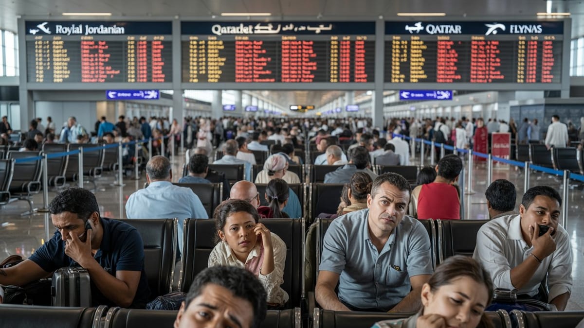
Flight disruptions mount at Denver International Airport
Publicly available flight-tracking data showed more than 300 flights delayed at Denver International Airport on Monday afternoon, with delays affecting both arrivals and departures as storms moved across the Front Range. Most services remained operational, but rolling disruptions created long lines at security checkpoints and gate areas as aircraft and crews fell out of position.
Information posted by the Federal Aviation Administration indicated that a traffic management program was put in place for arrivals into Denver because of thunderstorms in the vicinity of the airport. According to coverage from regional outlets, the measures were designed to slow the overall flow of air traffic into the airfield while keeping runways open when conditions allowed.
Flight boards at the airport reflected a patchwork of delay times ranging from less than an hour to more than two hours for some routes. The majority of services were still expected to operate, but airline operations centers across the country were adjusting schedules and rerouting aircraft to work around the evolving storm cells on Colorado’s plains.
Travelers with connections through Denver faced heightened uncertainty, with airline advisories urging passengers to check their flight status frequently and allow extra time at the airport. Some carriers also signaled that change-fee waivers could be available for the most heavily impacted itineraries, depending on how long the severe weather pattern persisted into the evening.
Ground stop issued as severe storms sweep metro area
According to published coverage from CBS Colorado and other local news organizations, a formal ground stop for departures bound for Denver was issued Monday afternoon as severe thunderstorms moved directly over the metro area. The order began around midafternoon and initially extended through 4 p.m. Mountain time before being prolonged as storms continued to redevelop.
The ground stop applied to flights departing from several air traffic control regions that feed traffic into Denver, effectively pausing new departures until conditions improved along the approach paths. Reports indicated that average arrival delays of roughly three quarters of an hour were recorded at various points during the afternoon, with the potential for longer waits as the strongest storms peaked.
Radar imagery and broadcast weather segments showed intense thunderstorms bubbling up along the northern Interstate 25 corridor, with frequent lightning, localized downpours and pockets of very heavy rain. For safety reasons, ramp activities such as baggage loading and aircraft servicing were occasionally halted when lightning was detected near the airfield, further contributing to the backlog of delayed flights.
While cancellations remained relatively limited compared with major winter storms or nationwide traffic disruptions, aviation observers noted that even a few hours of tightly concentrated thunderstorms can cause residual delays lasting well into the night. Crews may time out, aircraft may not reach their intended overnight locations and early-morning departures on Tuesday could also see knock-on effects.
Tornado watch stretches across Denver and Eastern Plains
The National Weather Service issued a tornado watch on Monday afternoon covering Denver and a swath of northeastern Colorado, including multiple counties on the Eastern Plains. According to summaries compiled by Colorado Public Radio and Denver-area television weather teams, the watch was scheduled to remain in effect until 9 p.m. as the most volatile atmosphere shifted eastward.
Forecast discussions highlighted a combination of warm surface temperatures, abundant low-level moisture and strong winds higher in the atmosphere, a setup known to support rotating thunderstorms. Meteorologists warned that a few storms could produce tornadoes along with very large hail, with some hailstones potentially exceeding golf-ball size, and straight-line wind gusts strong enough to damage roofs and trees.
The primary threat zone extended from the urban corridor eastward across the plains toward the Kansas border, placing Denver International Airport on the western fringe of the highest risk area. That geography meant fast-developing storms could approach rapidly from the west or southwest, prompting frequent updates to short-term forecasts and airport operations plans.
Local weather blogs and broadcast outlets urged residents and travelers to monitor alerts through the evening in case the tornado watch was upgraded to more urgent warnings for specific communities. For those in transit, interior areas of terminal buildings were described as safer options than curbside locations or open-air parking lots during the most intense cells.
What travelers should know if flying through Denver
For passengers heading to or from Denver on Monday, publicly available guidance from airlines and aviation agencies emphasized preparation and flexibility. Travelers were encouraged to use airline apps or text alerts to track gate changes and delay estimates in real time, rather than relying solely on airport monitors that can lag during fast-moving weather events.
Industry practice in situations like Monday’s storms typically includes allowing earlier rebooking when a significant risk of disruption appears in forecasts. While policies vary by carrier, some airlines may permit same-day changes within a defined travel window or waive change fees for affected routes, particularly if the FAA maintains traffic flow restrictions for several hours.
For those already at the airport, experts commonly recommend keeping essential items in carry-on bags in case of unexpected overnight stays, including medications, chargers and a change of clothes. With tornado watches and severe thunderstorm warnings in effect, travelers were also advised to follow airport staff instructions about moving away from windows or congregating in designated shelter areas if local alerts intensified.
Travelers with flexibility in their plans may find it advantageous to consider early-morning or late-night flights on subsequent days, when the immediate severe weather threat is expected to wane. Forecasts from regional outlets suggested a trend toward more stable conditions later in the week, which could help airlines work through any residual backlog and return operations closer to normal schedules.
Stormy start to June heightens seasonal weather risks
Monday’s severe weather over Denver arrived during a period that is climatologically active for thunderstorms across Colorado and the central United States. Late spring and early summer often bring repeated rounds of storms to the Front Range, as cooler air aloft overlies increasingly warm and humid air near the ground, creating the instability needed for vigorous convection.
Recent outlooks from national storm prediction centers have highlighted an elevated risk for severe thunderstorms across portions of the central Plains early this week, with Colorado near the western edge of a broader corridor of unsettled weather. That pattern aligns with what aviation planners describe as a “convective season,” when short-notice air traffic restrictions and weather-related delays become more common at hub airports like Denver.
For travelers, the episode underscores the importance of factoring seasonal weather into itinerary planning, particularly for tight connections or evening arrivals that may coincide with peak thunderstorm development. While Monday’s impacts were concentrated in a single metropolitan area, ripple effects across the national airspace system can extend to distant destinations when a major connecting hub experiences hours of rolling delays.
As the tornado watch approaches its scheduled expiration time, forecasters will be watching for any lingering storms that could still impact late-night departures and arrivals. Passengers with flights scheduled through Monday evening are being urged in public advisories to remain alert to changing conditions, even as the most intense storms gradually shift east of Denver.