
More news on this day
Severe overnight thunderstorms across southeast England on Saturday have caused major disruption at London’s Heathrow and Gatwick airports, delaying or cancelling hundreds of flights and creating knock-on problems for air travel across Europe.
Get the latest news straight to your inbox!
Hundreds of Flights Affected at London’s Busiest Hubs
Publicly available flight-tracking data and media coverage for Saturday 27 June indicate that Heathrow and Gatwick have borne the brunt of the storm-related disruption, with delays running to several hours on some services. Reports from multiple outlets describe queues of aircraft on the ground, lengthy waits for departure slots and a steady stream of schedule changes throughout the day.
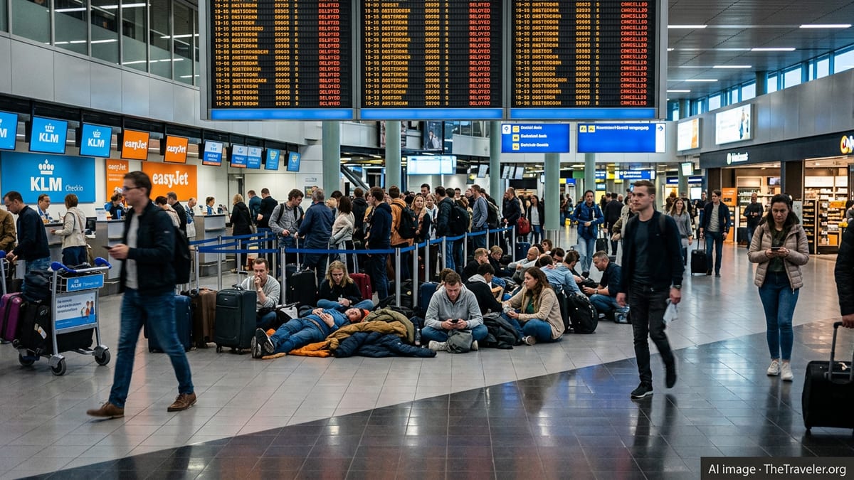
Estimates from services that monitor live aviation movements suggest that several hundred flights at Heathrow have been delayed and well over a hundred cancelled, while Gatwick has seen hundreds more delayed and dozens scrapped. The combined effect has left thousands of passengers facing missed connections, heavily disrupted itineraries and extended waits both on aircraft and inside terminals.
Accounts shared on social media platforms describe passengers stuck on board planes for hours as storm cells moved across the London area, with some long-haul arrivals diverted to other UK airports to ease congestion. Airlines running dense short-haul schedules from both hubs have warned of residual disruption even for flights that were not operating during the worst of the weather.
Industry-focused reports suggest that air traffic management constraints, rather than direct damage at the airports themselves, have driven much of the disruption. With large swathes of airspace temporarily restricted by the storms, aircraft movements in and out of the capital’s two busiest airports were sharply reduced for safety reasons.
Storms Follow Record Early-Summer Heatwave
The thunderstorms arrived after several days of intense early-summer heat across much of England, with meteorologists noting that temperatures had reached record or near-record highs for June in some areas. As cooler and more unstable air pushed into the hot, humid air mass over southeast England, heavy downpours, lightning and gusty winds developed overnight.
Weather specialists had flagged the risk of powerful convective storms forming along this boundary, warning that lightning, turbulent cloud towers and rapidly shifting wind patterns could all create hazardous conditions for aircraft. Such systems often develop quickly and cover large stretches of sky, forcing controllers to reroute traffic around the most active cells.
Forecasts issued on Saturday suggested that scattered storms could redevelop through the afternoon and evening not only over the London region, but also along key flight corridors connecting the United Kingdom with northern France, the Low Countries and western Germany. That pattern raised the prospect of further departure restrictions as controllers worked to maintain safe spacing between aircraft.
The episode has also been framed within a broader pattern of increasingly volatile summer weather in northwest Europe. Aviation safety publications and recent climate assessments have highlighted a rising incidence of intense, short-lived storms following prolonged heat, conditions that can overwhelm airport schedules even when physical infrastructure escapes serious damage.
Ripple Effects Across UK and European Air Networks
Although Heathrow and Gatwick recorded the heaviest concentration of delays on Saturday, publicly available information from European traffic agencies indicates that congestion has spilled into neighbouring airspace. Flights transiting to and from continental hubs such as Amsterdam, Paris and Brussels have faced additional airborne holding or rerouting as storm cells drifted across northwestern Europe.
Eurocontrol data and regional news coverage show that airspace over southeast England and nearby sea routes has been among the most constrained, affecting flights far beyond those simply taking off or landing in London. Aircraft attempting to skirt around the thunderstorms have lengthened flight paths and added to bottlenecks on alternative routes.
Within the United Kingdom, most other major airports have so far reported comparatively minor disruption, but some services have been indirectly affected when London-bound flights diverted or when aircraft and crews ended up in the wrong place. Aviation forums on Saturday carried reports of planes originally scheduled for London being rerouted to regional airports, with knock-on delays for subsequent services.
Travel analysts note that such ripple effects can take many hours, and sometimes days, to fully unwind. When aircraft miss their planned rotations, airlines are often forced to reshuffle fleets, consolidate lightly booked flights or position empty aircraft to restore normal schedules.
Airlines Adjust Schedules as Passengers Face Long Waits
Major carriers operating at Heathrow and Gatwick have adjusted their schedules in response to the reduced capacity. Public statements from several airlines referenced in media reports indicate that some flights were pre-emptively cancelled in order to keep the remainder of the timetable more resilient, a strategy commonly used when weather-related air traffic restrictions are expected to last for many hours.
Low-cost and network airlines alike have reported long queues at customer-service desks and call centers as travellers sought alternative routes or overnight accommodation. With some delays stretching to six hours or more, photos and videos shared publicly have shown crowded gate areas, extensive departure boards marked with delays, and passengers waiting aboard parked aircraft in humid conditions.
Travel-rights groups and consumer commentators have used the disruption to remind passengers of their entitlements under UK and European passenger-protection rules. While compensation for delays is often not payable when the root cause is classified as severe weather or air traffic control restrictions beyond an airline’s control, carriers are still expected to provide care such as meals, refreshments and, where necessary, hotel rooms.
Airlines have also urged passengers to make use of digital tools to rebook or check flight status, noting that customer-service capacity at airports can quickly become overwhelmed during major disruptions. For some travellers, re-routing via unaffected airports or accepting travel on a later date has offered the most reliable path to their destination.
What Travelers Can Expect in the Coming Hours
Meteorological outlooks for late Saturday and into Sunday suggest that the most intense thunderstorm activity over southeast England may gradually ease, but lingering showers, lower cloud and further patchy storms remain possible. Aviation observers expect that air traffic restrictions could continue intermittently until weather conditions stabilize over key approach and departure routes.
Even as the immediate storm threat passes, airlines and air traffic managers will face a substantial backlog of aircraft and crews positioned away from their planned locations. This means that early-morning departures on Sunday could still be disrupted, particularly on routes that rely on aircraft and staff arriving from heavily affected flights the previous evening.
Travel experts advise that anyone due to fly via Heathrow or Gatwick within the next 24 hours should monitor their flight status closely, arrive at the airport in good time if advised to do so, and be prepared for changes at short notice. Rail and road links serving both airports are currently reported to be operating broadly as normal, though heavier traffic is likely as some passengers switch from air to ground transport.
With high summer travel demand coinciding with increasingly volatile weather patterns, industry analysts note that similar episodes of storm-triggered disruption may become a more regular feature of the peak travel season. For now, London’s two main international gateways are working through one of their most challenging weather days of the year, as thunderstorms give way to a complicated recovery in the skies above southeast England.