
The first time many travelers drive into Banff or Jasper, they realize other mountain trips did not prepare them for this. Peaks that rise more than 1,500 meters straight from the valley floor, a highway that runs under hanging glaciers for hundreds of kilometers, and lakes so large and intensely colored they look edited: the Canadian Rockies have a way of making almost every other mountain destination feel smaller than expected. This is not just about elevation figures on a map. It is about how the landscape feels when you are standing on a shoreline or driving a valley bottom road with the walls of the continent closing in around you.
Get the latest updates straight to your inbox!
A Range Built on Sheer Vertical Drama
The Canadian Rockies stretch roughly 1,400 kilometers along the Alberta and British Columbia border, but what surprises visitors is not the length of the range so much as the vertical relief. Around Banff, Lake Louise, and Jasper, valley floors often sit between 1,300 and 1,600 meters above sea level, while peaks surrounding them climb to 3,000 meters and beyond. That means walls of rock and ice rising more than a vertical kilometer straight out of the forest, a contrast that feels more abrupt and imposing than many European valleys where high villages, rolling foothills, and pastureland soften the transition.
On the drive from Calgary into Banff, that sense of scale arrives very quickly. One minute you are in prairie farmland; within a couple of hours you are threading between Castle Mountain and Mount Temple, each towering above 3,000 meters. There is little sprawl at the edges of the towns, so when you step out of your car in Banff Avenue or at the Lake Louise lakeshore, cliffs and ridgelines fill the frame. Travelers who have spent time in popular U.S. ranges like Colorado’s Front Range often remark that the Rockies here feel “taller,” even when peak elevations are similar, simply because the relief between valley bottom and summit is greater and more concentrated.
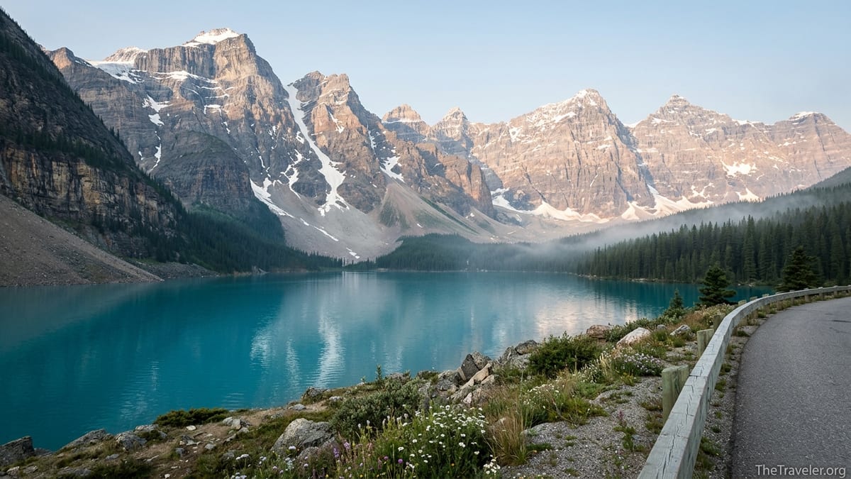
This verticality becomes even more striking in places like Moraine Lake, where the Valley of the Ten Peaks stacks one serrated summit after another directly above the turquoise water. Here it is easy to understand why photographs routinely fail to convey the real dimensions. Many visitors discover that hikes listed as “short” feel physically and visually overwhelming, not due to distance, but because every step is taken under cliffs, glaciers, and avalanche paths that press close to the trail.
Iconic Lakes That Redefine the Word “Scenic”
Photographs of Lake Louise and Peyto Lake are so familiar that some travelers worry the real thing might disappoint. The opposite is usually true. Standing on the shore of Lake Louise, you are looking at a body of water roughly 2 kilometers long and more than 90 meters deep, backed by Victoria Glacier and a line of peaks that climb almost 1,000 meters above the far end of the lake. The milky turquoise color comes from rock flour suspended in the meltwater, and in strong midday sun it can look almost opaque. First-time visitors who have loved alpine lakes in the Alps or the Rockies of Colorado often comment that the combination of color and vertical backdrop here feels exaggerated, almost like a movie set.
Peyto Lake, above the Icefields Parkway at Bow Summit, delivers a different version of the same lesson in scale. After a short uphill walk through subalpine forest, the trail pops out at a clifftop platform where the lake fills the valley below in an elongated wolf-head shape. On a clear July afternoon, dozens of people can stand in silence simply taking in the distance from foreground to far shore and the size of the glacier-fed basin. Even on busy days, the view seems to dwarf the crowd. Walk ten minutes along adjacent side paths and the chatter fades, leaving just the wind and the low rumble of distant traffic far below.
Even lesser-known lakes along the Icefields Parkway, such as Bow Lake and Waterfowl Lakes, feel supersized compared with what many travelers expect beside a major mountain highway. You can step out of the car into a small gravel pullout and find yourself at the edge of a broad, turquoise basin with summits and glaciers stacked behind it. In many destinations, such a place would require an hour-long hike. Here, it is often a casual stop between coffee in Lake Louise and lunch at the Columbia Icefield.
The Icefields Parkway: A Highway Through a Wall of Mountains
If a single road captures why the Canadian Rockies make other mountain destinations feel small, it is the Icefields Parkway. Running for about 230 kilometers between Lake Louise and Jasper, it is a continuously scenic corridor with views of more than 100 glaciers, multiple icefields, and countless unnamed peaks. Travelers compare it to America’s Going-to-the-Sun Road or Europe’s Grossglockner High Alpine Road, but the Parkway is significantly longer and maintains its high-mountain character for most of the drive. Long sections roll along valley bottoms hemmed in by cliffs, waterfalls, and hanging ice, with almost no services or development in between.
In practical terms, this changes how you plan a day. A drive that looks like a three-hour run on the map can easily stretch into eight or nine hours with stops at Bow Lake, Peyto Lake, Mistaya Canyon, the Weeping Wall, Sunwapta Falls, and Athabasca Falls. Each of these is a destination-level stop in its own right, with short walks to canyons or lakes that would anchor entire excursions elsewhere. Here they line up, one after another, along a single stretch of highway. It is common to meet road-trippers in Jasper who admit they underestimated the time they would want to spend on the Parkway and now wish they had booked a night at a lodge or campground halfway instead of treating it as a simple transfer day.
The Columbia Icefield, roughly the midpoint of the route, emphasizes the continental scale at work. From the Glacier Discovery Centre parking area, the Athabasca Glacier spills down almost to the valley floor, with the broader Columbia Icefield extending back into a high, white plateau hidden behind corniced ridges. Interpretive signs explain that meltwater from this ice flows to three different oceans. Visitors can see tour buses that drive onto the lower glacier, but even those oversized vehicles look like toys against the background of ice and rock. For travelers coming from smaller glaciated ranges, it is often their first time seeing a mass of ice that stretches beyond their field of view in multiple directions.
Bigger Wilderness, Thinner Crowds Once You Step Off the Pavement
Popular viewpoints such as Lake Louise or Moraine Lake can feel crowded during peak season, especially in July and August when Banff National Park’s monthly visitor numbers spike. Shuttle systems, reservation-only parking at Moraine Lake, and managed access at Lake Louise have all been introduced to cope with demand. Yet one of the defining aspects of the Canadian Rockies is how quickly that density drops away once you leave the roadside hotspots. A twenty-minute walk on the shoreline trail at Lake Minnewanka often leads to stretches where you might meet only a handful of other people, even on a busy afternoon in August.
Longer day hikes such as Sentinel Pass, Wilcox Pass near the Columbia Icefield, or the Skyline Trail above Jasper demonstrate just how much space there is behind the popular viewpoints. Once you climb above the treeline, you can look across valleys that run unbroken for tens of kilometers, with no lift infrastructure, no villages, and often no visible trails beyond the one under your feet. Compared with compact European resorts where gondolas and access roads crisscross most valleys, the feeling here is of a contiguous wilderness that extends well beyond what you can cover in a single trip.
Backcountry travelers experience this even more intensely. Multi-day routes such as the Brazeau Loop in Jasper or the Rockwall in Kootenay involve days on end of high passes, broad alpine basins, and campsites set beneath cliffs where waterfalls drop hundreds of meters. Many of these areas have permit quotas to protect the environment and preserve a sense of remoteness. That means you may share a campground with just a handful of tents, despite being only a half-day hike away from a parkway that carries hundreds of thousands of people every season.
Comparing the Canadian Rockies to Other Great Mountain Regions
Travelers who arrive with extensive experience in the Alps, the U.S. Rockies, or New Zealand’s Southern Alps often struggle to explain why this region feels so much bigger. Part of it is the combination of latitude and continental climate. The Canadian Rockies sit far enough north that tree line is relatively low, so alpine scenery begins earlier on hikes and along roads. At the same time, the peaks themselves are massive, so the band of rugged high country between tree line and summit is wide. When you stand on a viewpoint like Parker Ridge above the Icefields Parkway, the sense is of an entire skyline of summits and glaciers within arm’s reach, not a single iconic peak rising above gentler surroundings.
Infrastructure also shapes the impression of scale. In the Alps, a single valley may hold multiple villages, lift networks, rail lines, and pastures. The Canadian Rockies, by contrast, concentrate development in a small number of towns and highway corridors, leaving large swaths of the range roadless. There are no cable cars swinging up every major ridge above Banff or Jasper. For visitors used to seeing restaurants at high passes and ski lifts on most slopes, the absence of this infrastructure reinforces the feeling that the mountains are too big and too wild to be easily tamed.
Even when you compare individual experiences, the difference shows. A scenic drive like Colorado’s Trail Ridge Road crests above 3,600 meters and offers sweeping alpine views for several dozen kilometers. The Icefields Parkway sustains subalpine and alpine scenery for more than 200 kilometers. Similarly, while lakes like Italy’s Lago di Braies or Switzerland’s Oeschinensee are beautiful, they are often framed by more rounded, forested slopes and human infrastructure such as chairlifts and hotels. In the Canadian Rockies, lakes of similar beauty tend to sit beneath steeper, less developed walls, and that visual contrast registers immediately, even if you cannot articulate why.
Planning a Trip That Matches the Scale
The biggest planning mistake in the Canadian Rockies is underestimating how much time you will want in each area. On paper, it is possible to drive from Calgary to Banff in about 1.5 hours, from Banff to Lake Louise in 45 minutes, and from Lake Louise to Jasper via the Icefields Parkway in roughly three hours without stops. In reality, most travelers find that a week barely scratches the surface. A common first-time itinerary of three nights in Banff, two in Jasper, and a final night near Lake Louise often leaves people wishing they had added extra days for weather flexibility and slower exploration.
Season makes a difference. July and August bring the warmest temperatures and the widest trail access but also the largest crowds and highest prices for hotels in Banff, Jasper, and Lake Louise. Shoulder seasons in June and September can be a sweet spot, with long daylight hours, more availability, and a good balance of snow-free low and mid-elevation hikes, though lingering snow may still cover some passes early in June. In October, larch forests around Lake Louise and in the Moraine Lake area turn golden for a brief window, creating one of the most dramatic autumn spectacles in any mountain range, though services and shuttles begin winding down.
Practical details also scale up. Distances between services are longer than many European or U.S. visitors expect. Fuel up before driving the Icefields Parkway, carry food and water rather than relying on frequent gas stations or cafes, and be prepared for limited mobile reception along major stretches of road. Accommodation close to the busiest hubs, especially in July and August, often books out months in advance. If you are planning to stay at lodges along the Parkway or in small places like Field or Saskatchewan River Crossing, treat those reservations as early priorities, not last-minute details.
Reading the Landscape: Glaciers, Icefields, and Wildlife at Scale
One reason the Canadian Rockies impress so deeply is that they are still very much a working landscape, shaped in obvious ways by ice, water, and wildlife. Visitors driving past the Athabasca Glacier can see date-marked signs along the access road showing how far the ice has retreated over the last century, a sobering visual of climate change on a continental icefield. From roadside viewpoints near the Columbia Icefield, you can track meltwater routes down braided rivers that will eventually feed three separate ocean basins. That kind of hydrological crossroads is something you rarely encounter on a typical mountain vacation.
Wildlife contributes to the sense of scale too. Sightings of elk, bighorn sheep, mountain goats, and black bears are common along main roads, and patient visitors occasionally glimpse grizzly bears or wolves from a safe distance. The key is to respect the space these animals need. Park regulations require staying well back and never feeding or approaching wildlife, both for their safety and yours. When you watch a grizzly moving across a scree slope the size of a football stadium, it drives home just how extensive the habitat is beyond the viewpoint where your vehicle is parked.
Weather can amplify the grandeur. Storm systems funneling along the mountain front can cloak entire valleys, then lift suddenly to reveal fresh snow dusting peaks above sunlit forests. Temperatures can drop quickly even in midsummer, especially near glaciers or on high passes. It is not uncommon to leave Calgary in T-shirt weather in July, arrive at Bow Summit or the Columbia Icefield and find yourself pulling on a fleece and rain shell against a stiff, cold wind. Packing layers and respecting forecasts is more than a comfort issue here; it is an acknowledgment that you are operating in a environment scaled for extremes.
The Takeaway
Many travelers arrive in the Canadian Rockies expecting another beautiful mountain trip and leave feeling their internal sense of scale has been permanently reset. The combination of deep valleys, massive peaks, expansive icefields, and lakes of improbable color stacks one big experience on top of another. Roads such as the Icefields Parkway, which would be signature attractions in other countries, function here as everyday connectors between even more dramatic areas.
What ultimately sets this region apart is not just its statistics but the way it makes you feel small in the best possible way. Standing on the shore of Lake Louise at dawn or at a pullout beneath the Athabasca Glacier, you are reminded that you are a guest in a landscape that operates on geologic and continental timeframes. Planning enough time, approaching with humility, and being willing to slow down long enough for the magnitude to sink in are the best ways to ensure that when you leave, other mountain destinations will feel, as many travelers put it, just a little smaller than you remembered.
FAQ
Q1. How many days do I really need in the Canadian Rockies to appreciate the scale?
Most first-time visitors should plan at least seven to ten days, with several nights each in Banff, Jasper, and the Lake Louise area to avoid rushing the major highlights.
Q2. When is the best time of year to visit for big mountain views and accessible trails?
Late June through mid-September usually offers the best combination of open roads, mostly snow-free mid-elevation trails, and long daylight, though July and August are the busiest.
Q3. Is the Icefields Parkway a day trip or should I stay overnight along the route?
Driving the full Icefields Parkway in one long day is possible, but many travelers prefer one or even two nights along the route to enjoy lakes, canyons, and short hikes without rushing.
Q4. Do I need a car to experience the sheer scale of the Canadian Rockies?
A car or campervan offers the most flexibility, especially for the Icefields Parkway, but shuttle buses, guided tours, and transit options from Banff and Jasper can still deliver big-mountain scenery.
Q5. Are popular spots like Lake Louise and Moraine Lake still worth visiting despite the crowds?
Yes. Managed access and shuttle systems concentrate people but protect the experience, and visiting early in the morning or later in the evening can make these big landscapes feel more tranquil.
Q6. How does the size of the Canadian Rockies compare with the Alps or Colorado Rockies?
Peak elevations are similar, but steeper valley walls, lower tree line, larger icefields, and less development give the Canadian Rockies a wilder, more expansive feel.
Q7. What kind of weather should I prepare for in summer?
Even in July and August you can encounter cool, windy conditions near glaciers and on passes, so pack layers, a warm midlayer, and a waterproof jacket along with lighter clothing.
Q8. Can I see glaciers up close without technical mountaineering experience?
Yes. Roadside viewpoints near the Columbia Icefield, short walks such as Parker Ridge, and guided glacier tours allow you to see and learn about glaciated terrain safely.
Q9. How busy are the trails once I get away from parking lots and viewpoints?
Short, famous walks can be busy, but crowds thin quickly beyond the first few kilometers, and many full-day and backcountry routes offer long stretches of solitude even in peak season.
Q10. Do I need to worry about wildlife encounters on hikes and scenic drives?
Wildlife is common, so carry bear spray where recommended, make noise on trails, follow park guidelines, and stay well back from animals you see alongside roads or paths.