
The Canadian Rockies are often summed up in three postcard images: a turquoise lake, a gleaming glacier and a skyline of jagged peaks. Yet what actually defines a Canadian Rockies experience goes far beyond a single overlook on a sunny day. It is the way icefields feed milky rivers, the way clouds snag on serrated ridgelines, the way a small resort town feels after a day on the trail. From Banff and Lake Louise through Jasper and Yoho, this landscape is a living system of glaciers, lakes and mountains that you move through, not just look at. Understanding how these pieces fit together is the key to planning a trip that feels like the Rockies you have always imagined.
Get the latest updates straight to your inbox!
What Really Makes the Canadian Rockies Feel Different
On a map, the Canadian Rockies are simply the eastern edge of the greater Rocky Mountain chain. In reality, they feel very different from Colorado or Wyoming. The defining impression most travelers report is the vertical drama: limestone and dolomite walls rising almost straight out of deep valleys, with hanging glaciers and permanent snowfields clinging to their upper ramps. Peaks around Banff and Jasper may be similar in elevation to high summits in the American West, but the valley floors are lower, so the relief between river and ridgeline often exceeds 1,500 meters in a single view.
Water is the second signature. These mountains are built on sedimentary rock rich in rock flour, the ultrafine glacial silt that turns lakes an electric turquoise. When you first see Moraine Lake or Peyto Lake in Banff National Park, the color often looks edited until you notice the same milky blue in the river channels and roadside ponds. Those hues are not a trick of the light but a direct expression of glaciers grinding away at bedrock upstream.
Third is the density of protected areas. Banff, Jasper, Yoho and Kootenay national parks connect to create a UNESCO World Heritage Site more than 20,000 square kilometers in size, ringed by provincial parks and reserves such as Kananaskis Country. That means you can drive for hours along the Icefields Parkway between Lake Louise and Jasper and see nothing but peaks, ice and forest, but still have regular pullouts, safety services and signed trails.
Finally, there is a specific Canadian Rockies culture: small resort towns like Banff, Lake Louise, Jasper and Field that live and breathe the seasons. Cafes open early for hikers catching sunrise shuttles, rental shops talk as much about avalanche conditions as gear, and local advice often shapes your trip more than any brochure. These human layers help turn the scenery into a lived experience rather than a series of photo stops.
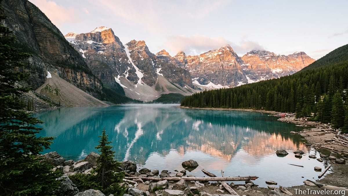
Glacial Lakes: The Iconic Turquoise Heart
The mental picture many travelers carry of the Canadian Rockies starts with a single scene: a turquoise lake backed by a glaciated wall. Lake Louise and Moraine Lake in Banff National Park are the best known examples, so popular that Parks Canada now manages access primarily by shuttle to protect the shorelines and manage crowds. In 2026, shuttle reservations for these lakes opened in mid April and tens of thousands of people joined the booking queue within minutes, a sign of how sought after this specific kind of view has become.
What makes these lakes distinctive is not only their color but their setting. Lake Louise, at roughly 1,750 meters elevation, sits directly below the Victoria Glacier. Standing on the lakeshore you can trace the cascade of ice and rock from the glacier down to the water, connecting the distant accumulation of snow to the ripples at your feet. Moraine Lake, set in the Valley of the Ten Peaks, focuses your eye on a tight semicircle of summits that rise as a nearly continuous wall, with hanging glaciers and snowfields feeding streams that enter the lake in silty braids.
Beyond these headliners, dozens of other glacial lakes define the region. Peyto Lake, visible from a short walk above the Icefields Parkway, fans out in a wolf head shape and glows especially bright in midsummer when meltwater from the Wapta and Waputik icefields is at its peak flow. In Yoho National Park, Emerald Lake reflects a gentler amphitheater of peaks but shows the same opaque color, especially after heavy rain or fast melt. Even larger bodies such as Lake Minnewanka near Banff townsite carry a subtler version of that glacial tint, especially along their inflow bays.
From a practical standpoint, these lakes also organize your days. A typical first Rockies itinerary might anchor one day at Lake Louise, combining a shoreline walk with a half day hike up to the Plain of Six Glaciers tea house. Another day might focus on Moraine Lake, timing a sunrise visit by shuttle and then continuing to Consolation Lakes. Each of these outings delivers a slightly different angle on the same core experience: feeling how meltwater, rock and light interact to create the famous blue.
Glaciers and Icefields: Walking on the Source
To understand the Canadian Rockies fully, it helps to move upstream from the lakes to the ice that feeds them. The region’s glaciers are mostly fragments of larger icefields that drape the Continental Divide. The Columbia Icefield between Lake Louise and Jasper is the most accessible example, with several outlet glaciers pouring down towards the Icefields Parkway. One of them, the Athabasca Glacier, comes close enough to the valley floor that you can walk to its current toe on a marked trail and see year by year signs of how far it has receded.
Guided experiences here illustrate both the thrill and the fragility of this landscape. Commercial tours using all-terrain buses still travel onto a safe section of the Athabasca Glacier in summer, allowing visitors to step onto the ice itself. Interpretive rangers and guides typically talk about how this glacier has thinned and retreated over the past century, and how the Columbia Icefield feeds three major river systems that drain to the Arctic, Atlantic and Pacific oceans. Even if you skip the organized tours and simply hike to the toe, you will pass date markers showing where the ice reached in past decades, making climate change tangible in a single walk.
Other icefields are less directly accessible but still shape the experience. The Wapta and Waputik icefields above Lake Louise and Yoho form a high white horizon that you notice from different vantage points: as a gleaming backdrop behind Takakkaw Falls, as the broad snowfields you glimpse from the Iceline Trail, or as the distant plateau visible from alpine huts used by mountaineers in winter and spring. Even without stepping onto them, you feel their presence in cool valley winds and the constant sound of meltwater creeks.
For travelers curious about more technical glacier travel, certified guides based in towns like Canmore, Banff and Jasper offer small group trips onto less crowded ice, particularly in late summer when crevasses are more visible but routes are well established. These outings require proper equipment, fitness and an acceptance of variable weather, yet they can be one of the most powerful ways to connect the abstract concept of an icefield to the lakes and rivers you have been photographing from the road.
Peaks, Passes and the View From the Trail
While lakes and glaciers define many photographs, the emotional memory many visitors carry home is the feeling of standing on a high pass and looking down on entire valleys. The Canadian Rockies lend themselves to this perspective because many classic day hikes climb quickly out of the forest into open bowls, ridgelines or passes framed by distinctive peaks. Trails like Sentinel Pass above Moraine Lake, Larch Valley in autumn, or the Iceline Trail in Yoho all offer that coveted combination of moderate effort and disproportionate reward.
The mountains themselves have complex personalities. Some, such as Castle Mountain above the Bow Valley, present a clean horizontal skyline of cliffs that glows orange at sunrise. Others, like the Ten Peaks surrounding Moraine Lake or the jagged spires above Jasper’s Skyline Trail, bristle with serrated ridges and fin-like buttresses. On an overcast day the rock can look almost monochrome, but when the sun breaks through after rain, bands of different limestone and shale layers become visible as subtle stripes.
From a practical planning angle, understanding the vertical nature of these peaks matters. Many signature viewpoints require a significant climb: the Plain of Six Glaciers lookout sits over 400 meters above Lake Louise, while Sentinel Pass climbs roughly 700 meters from the valley floor. Visitors who are used to gentle national park strolls can be surprised at how quickly these trails gain elevation and how late snow lingers. In a typical year, higher passes may hold snow and even avalanche hazard into June, which is why local advice and recent trail reports are more important here than simply reading distances on a map.
At the same time, not every peak experience demands a big hike. Shorter walks like Johnston Canyon near Banff or the boardwalks at Athabasca Falls and Sunwapta Falls in Jasper give glimpses of steep canyon walls and powerful water without major elevation gain. Gondolas at Banff and Lake Louise, and the Jasper SkyTram, offer quick access to treeline views where you can wander along short ridge trails and feel surrounded by peaks without committing to a full day outing.
Seasons, Light and the Rhythm of a Rockies Trip
Because so much of the Canadian Rockies experience depends on snow, ice and water, timing has an outsized impact. Summer, particularly July and August, offers the fullest access to high trails, open lakes and long daylight hours, but it also brings the heaviest crowds. Banff National Park now sees well over four million visitors a year, and recent summers have set new visitation records, especially during free admission promotions. In high season, sunrise can be before 6 am and sunset after 10 pm, which means both longer traffic peaks and more room to spread out your day.
Shoulder seasons provide different moods. Late May and June often show a split personality: valley bottoms are green and snow free while higher hikes remain partially buried. Waterfalls, including Yoho’s Takakkaw Falls, tend to be at their most powerful during the peak snowmelt weeks. September has become a favorite among those seeking calmer trails, with larch trees around Moraine Lake and Lake Louise turning gold and evenings carrying a hint of frost. Some services wind down after Canadian Thanksgiving in October, and roads to certain trailheads close seasonally once snow makes them unsafe.
Winter transforms the equation entirely. While many hiking routes are closed or unsafe due to avalanche risk, the mountains become a hub for skiing, snowshoeing and ice walks. Resorts like Sunshine Village and Lake Louise in Banff, and Marmot Basin near Jasper, offer one of the longest ski seasons in North America, often from November through May. Town streets fill with parka-clad visitors, and experiences shift from lakeside paddling to soaking in hot springs or joining guided ice walks through canyons where waterfalls have frozen into blue columns.
Light itself becomes an element of your planning. Photographers often design days around sunrise and sunset at particular lakes or viewpoints, chasing alpenglow on peaks like Mount Rundle above Banff or the Victoria Glacier above Lake Louise. In summer, that can mean catching a 4 am shuttle departure to Moraine Lake; in autumn, the same colors may appear after a leisurely breakfast. Being realistic about how often clouds, rain or wildfire smoke can obscure views is part of crafting a satisfying trip. The Canadian Rockies reward patience as much as precision.
Human Scale: Towns, Shuttles and the Reality of Visiting
The romance of glaciers and peaks is only half the story. The way you move through this landscape shapes how it feels. In the past decade, the biggest practical change has been the shift from almost unlimited private car access to a managed system of shuttles, passes and timed parking at the most popular lakes. For example, personal vehicles are no longer allowed to drive to Moraine Lake, and reaching it now requires a Parks Canada shuttle, public bus or commercial tour from the Lake Louise Park and Ride. Similar controls are tightening around parking at Lake Louise itself, where steep daily parking fees and full lots by early morning are the norm in summer.
For travelers, this can initially feel like a barrier, but it often improves the actual experience. Instead of circling for parking at 5 am, you arrive with a reserved shuttle time, step off directly at the lakeshore and know you have a guaranteed ride back later in the day. On the Icefields Parkway, fuel stops are limited to a handful of service stations such as the ones at Saskatchewan River Crossing and Jasper, which encourages visitors to think about distance, fuel and weather in a more mindful way than on a typical highway.
Costs are part of the picture too. A family staying in Banff in midsummer might pay a moderate daily park pass fee, shuttle fares for popular lakes and higher peak-season hotel rates, but may spend relatively little on in-park transportation beyond that because the main towns are walkable and have local transit. Travelers on a tighter budget often base themselves slightly outside the park in communities like Canmore or field in British Columbia, trading a daily drive for lower accommodation rates, while still accessing the main sites by day.
Local knowledge is invaluable in navigating all this. Visitor centers in Banff, Lake Louise and Jasper track trail conditions, wildlife closures and shuttle systems in real time, and staff are used to helping people rework day plans around weather, smoke or full bookings. Spending 20 minutes there at the start of a trip often saves hours of frustration later, and it can lead you to quieter lakes, lesser-known passes or evening wildlife drives that still deliver the essence of a Rockies experience without the biggest bottlenecks.
Putting It Together: Sample Ways to Experience the Rockies
Understanding what defines the Canadian Rockies in theory is one thing; feeling it on the ground is another. A classic first-time trip might begin with two or three nights in Banff, where you can adjust to the altitude with gentle outings around the Bow River, Vermilion Lakes and the short climb up Tunnel Mountain. Evenings spent on Banff Avenue with views of Cascade Mountain help anchor you in the setting before you push deeper into the parks.
From there, many travelers move to Lake Louise for a couple of nights to focus on lakes and mid-elevation hikes. One full day might be devoted to Lake Louise itself, walking the lakeshore, renting a canoe in calm morning water and hiking to viewpoints above the Victoria Glacier. Another day could revolve around an early shuttle to Moraine Lake, a sunrise on the Rockpile and a hike through Larch Valley to Sentinel Pass if conditions allow. In both cases, you are seeing the same ingredients glaciers, lakes and peaks from progressively more immersive vantage points.
The next logical step is a drive up the Icefields Parkway to Jasper. This road is frequently cited as one of the most scenic in the world, and the journey is as important as the destination. Stopping at Bow Lake, Peyto Lake, the Columbia Icefield and Sunwapta or Athabasca Falls breaks the trip into manageable sections. In Jasper, the pace slows further. Lakes like Maligne, Annette and Edith offer kayak or canoe rentals, while the Jasper SkyTram gives a quick route to high views over the Athabasca Valley. Even a simple evening spent watching light fade on Pyramid Mountain from the town’s riverfront captures the quiet side of the Rockies.
Travelers with more time often add Yoho National Park to the loop, basing in or near the tiny community of Field. Here the focus shifts slightly from turquoise lakes to waterfalls and high alpine meadows. Emerald Lake, the Natural Bridge over the Kicking Horse River and Takakkaw Falls show how glacial meltwater carves and drops through this side of the divide. Hiking the Iceline Trail lets you walk along moraines and high benches with constant views of icefields and sound of rushing water. What ties all these days together is not a checklist of sights but a growing sense of how the landscape functions.
The Takeaway
When people talk about the Canadian Rockies, they often default to a handful of famous views. Yet what truly defines the experience is the constant relationship between glaciers, lakes and peaks as you move through them. Turquoise water makes sense because you have stood at the toe of a glacier. The scale of a mountain wall impresses you more because you have seen the valley it towers over in different seasons and lights. The shuttle systems, trail reports and weather warnings are not obstacles but tools that allow millions of people to enter a sensitive, rapidly changing environment with some measure of care.
Whether you come for a long weekend around Banff or a two week journey linking Banff, Yoho and Jasper, the key is to think in systems rather than single stops. Build your days around water flowing from ice to river, around the changing angle of the sun on major peaks, and around your own energy and curiosity. If you do, the Canadian Rockies will feel less like a series of bucket list photographs and more like a complete, living place you have begun to understand.
FAQ
Q1. Do I need a car to experience the best lakes and peaks in the Canadian Rockies?
You can reach many highlights without a private car by combining airport shuttles, local buses and Parks Canada shuttles, especially around Banff, Lake Louise and popular lakes like Moraine and Minnewanka. A car does add flexibility for sunrise starts, lesser known trailheads and side trips along the Icefields Parkway, but it is no longer essential for a rewarding first visit.
Q2. When is the best time of year to see turquoise lakes at their brightest?
Glacial lakes usually show their most vivid turquoise color from late June through early September, when warmer temperatures melt more glacial ice upstream and increase the amount of fine rock flour in the water. Earlier in the season some lakes may still be partially frozen, while later in autumn the color can soften as inflows decrease and light angles change.
Q3. How far in advance should I book shuttles to Lake Louise and Moraine Lake?
For peak summer dates, it is wise to reserve Parks Canada shuttles as soon as bookings open for the season, which typically happens in spring and can attract large online queues. If you miss the initial window, watch for last minute releases and consider less popular times of day such as late afternoon, when demand can be slightly lower than sunrise or mid morning.
Q4. Are glacier tours on the Columbia Icefield suitable for children and older travelers?
Most commercial glacier tours are designed to be accessible to a wide range of ages, with short walks on gentle ice and transportation provided by all terrain buses. That said, the environment is cold, windy and at higher elevation, so warm layers, sturdy footwear and realistic expectations about comfort and mobility are important, particularly for very young children or anyone with heart or breathing conditions.
Q5. Can I safely hike to high passes without mountaineering experience?
Many popular high pass hikes in the Canadian Rockies, such as Larch Valley to Sentinel Pass or the Iceline Trail, are non technical in summer conditions and do not require ropes or specialized climbing skills. However, they do involve significant elevation gain, uneven terrain and potential exposure to sudden weather changes, so good footwear, layered clothing, plenty of water and familiarity with basic trail safety are essential, and early or late season trips may require additional caution due to lingering snow.
Q6. How bad are crowds at famous viewpoints like Moraine Lake?
In July and August, iconic spots can feel very busy between mid morning and late afternoon, with steady shuttle arrivals and limited quiet space on small shorelines or viewing platforms. To experience a more peaceful atmosphere, aim for the earliest or latest shuttles of the day, visit during shoulder seasons such as June or September, or balance marquee locations with less known lakes and viewpoints recommended by local visitor centers.
Q7. Is it possible to see wildlife while focusing mainly on lakes and peaks?
Yes, wildlife often appears along the same corridors visitors use to reach lakes, passes and viewpoints, including elk in valley meadows, bighorn sheep on roadcuts and occasional bears feeding on slopes or berry patches. The key is to keep a safe distance, remain inside your vehicle when viewing animals from the road, carry bear spray when hiking and follow all posted closures or group size requirements designed to protect both wildlife and people.
Q8. How should I prepare for rapidly changing mountain weather?
Even on seemingly stable summer days, temperatures in the Canadian Rockies can shift dramatically between valley floors and high passes, and storms can build quickly over ridges. Pack a waterproof shell, insulating mid layer, hat and gloves on any hike above treeline, check the latest forecasts and trail reports before you leave town, and be willing to turn back if thunder, heavy rain or falling temperatures make continuing unsafe or unpleasant.
Q9. Are there alternatives if shuttle reservations are sold out?
If official shuttles are full on your preferred dates, options include visiting at less popular times of day, joining a commercial sightseeing or hiking tour that has its own transportation allocation, or choosing other lakes and viewpoints that capture similar scenery with fewer logistical constraints. In some cases, simply shifting your itinerary by a day or two or visiting in shoulder season opens up more availability and calmer conditions.
Q10. How many days do I need to feel the essence of the Canadian Rockies?
With three full days you can get a strong first impression by focusing on Banff, Lake Louise and one or two classic lakes or short hikes. A week allows time to include Moraine Lake, the Icefields Parkway and at least one high pass day hike, while ten days or more lets you weave in Jasper or Yoho and experience how glaciers, lakes and peaks connect across a larger stretch of the range.