
Abrams Falls sounds like the perfect “quick waterfall hike” in Great Smoky Mountains National Park: roughly 5 miles round trip, modest elevation change, and a big payoff at a thunderous 25-foot cascade. On paper it reads like an easy family outing. In reality, this Cades Cove classic is rougher, hotter, and more demanding than many visitors expect, especially on busy summer weekends. Understanding what the trail is really like can mean the difference between a memorable day and a miserable slog.
Get the latest updates straight to your inbox!
Where Abrams Falls Trail Fits in the Smokies
Abrams Falls Trail begins near the far end of the one-way Cades Cove Loop Road in the west side of Great Smoky Mountains National Park, about a 45-minute drive from Townsend, Tennessee in light traffic. The hike follows Abrams Creek to a powerful waterfall that drops about 20 to 25 feet into a large plunge pool surrounded by hemlock and rhododendron. The route is often described as 5 miles round trip, with roughly 600 to 700 feet of cumulative elevation gain because the trail repeatedly climbs and descends small ridges along the creek.
Compared with better-known Smokies climbs like Alum Cave to Mount LeConte or the 4,000-foot grind to Rainbow Falls and Bullhead, Abrams Falls does sound tame. Those marquee hikes gain thousands of vertical feet over 6 to 11 miles and are correctly labeled strenuous. Abrams, by contrast, is often tagged as “moderate,” and that simple word is where many first-time visitors get tripped up. Moderate in Smokies terms still means narrow tread, roots and rocks underfoot, short but steep pitches, and real exposure to summer heat and humidity.
In online trip reports and recent trail guides, Abrams Falls regularly ranks among the park’s most popular waterfall walks, alongside Laurel Falls and Grotto Falls. What separates it is that you earn the view. There is no paved path, no roadside overlook, and no shuttle. You commit a half day to driving Cades Cove’s slow loop road, hiking a sometimes-rugged trail, and then retracing the entire route back to your car.
Why a 5-Mile “Moderate” Hike Feels Harder
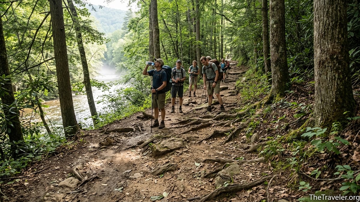
The main surprise on Abrams Falls Trail is how physical it feels for its mileage. From the trailhead you cross a wide wooden bridge over Abrams Creek, then almost immediately start a rolling pattern that defines the route: contour close to the creek, climb over a forested ridge, drop back to water level, and repeat. None of the climbs are individually huge, but taken together they add up to several hundred feet of gain and loss in each direction.
Underfoot, the trail is often uneven. Expect embedded roots, loose rocks, and occasional eroded steps that require high knee lifts. After a wet spell, seeps and side streams can turn sections of the tread into slick mud. Hikers who are used to groomed urban greenways or the paved path to nearby Laurel Falls are often taken aback that a “popular family hike” requires careful foot placement for much of the way.
The heat factor surprises people too. Cades Cove sits at a relatively low elevation compared with places like Newfound Gap or Clingmans Dome. On a July afternoon, it can easily be in the mid-80s Fahrenheit with heavy humidity, while higher-elevation trailheads feel almost cool. Once you leave the parking lot at Abrams, there is no potable water and very little breeze in the trees. Visitors who start at 1 p.m. after a slow drive around the loop often discover just how draining a 5-mile hike can be when it feels like walking in a sauna.
Finally, the out-and-back nature of the trail means the work is doubled. The rocky switchbacks you happily trotted down in the cool morning become the steep, dusty climb you must haul yourself up late in the day. This psychological effect is especially noticeable with children and newer hikers, who may spend their energy in the first hour only to realize they have to do it all again to get back to the car.
Real-World Trail Experiences: What Visitors Report
Recent trip accounts from hikers arriving in summer illustrate the gap between expectations and reality. A family from Ohio, used to walking three-mile suburban trails, planned Abrams Falls as a “quick hike before dinner” while staying in Pigeon Forge. Between the 25-mile drive to Cades Cove, traffic delays on the loop road, and the trail itself taking nearly three hours with rest stops, they returned to their car nearly six hours after leaving their rental cabin, sunburned and exhausted.
Another example is a couple from Florida who visited in May and started the hike at midday. They reached the falls without too much trouble but underestimated how the rolling terrain on the way back would feel once the temperature rose. Their 1-liter water bottles were empty with more than a mile left, and they described the final uphill stretch into the parking lot as “harder than any gym workout at home.” Experiences like this are common enough that park staff and local outfitters consistently recommend carrying more water than you think you will need.
Even fit hikers notice the effort. Trail runners who breeze through urban 10Ks often comment that Abrams’ constant up-and-down rhythm makes it hard to establish a steady pace. A recent GPS track from a hiking app showed a moving time of just under two hours for a reasonably fast hiker, with total time closer to three hours after factoring in photo stops, water breaks, and half an hour at the falls. When planning your day, it is more realistic to think of Abrams Falls as a substantial half-day outing than a casual stroll.
Trail Conditions, Hazards, and Safety at the Falls
Trail conditions on Abrams Falls fluctuate with weather and visitation, but several consistent hazards make the hike more serious than its mileage implies. The path runs close to steep drop-offs in a few spots, especially where it contours along slopes above the creek. After heavy rain, sections can be muddy and slick, particularly on exposed roots that act like wet cables under your boots. Hiking poles are not mandatory, but many visitors find them helpful for balance on the uneven tread and creekside rocks.
Wildlife encounters are another factor. Cades Cove is famous for its black bear sightings, and bears occasionally appear along or near the Abrams Falls Trail. The National Park Service periodically closes the trail for bear activity, including temporary closures in recent seasons when bears became overly accustomed to people or food. Visitors should be prepared to encounter bears at a distance, know how to react calmly, keep all food sealed, and never approach wildlife for photos.
The waterfall itself, while beautiful, presents the most serious danger. The wide plunge pool beneath Abrams Falls looks inviting on hot days, but the park service strongly warns against swimming. Powerful currents and undertows swirl beneath the surface, and slippery rocks around the pool have contributed to numerous injuries and drownings over the years. A typical summer scene includes people climbing on wet boulders for photos, which is where twisted ankles and falls most often occur. The safest way to enjoy the falls is from dry, stable viewpoints slightly back from the water.
Rescue operations from Abrams Falls are complicated. Reaching an injured hiker several miles from the trailhead involves rangers and sometimes volunteer teams carrying heavy equipment over the same rugged path you hiked in on. A sprained ankle or heat illness far from the parking lot can quickly escalate into a multi-hour evacuation. Wearing sturdy footwear, pacing yourself, drinking steadily, and turning around if you start to feel lightheaded or unsteady are simple steps that dramatically reduce the risk of becoming one of those emergencies.
Planning Your Visit: Timing, Parking, and Crowds
Because the trailhead is inside the one-way Cades Cove Loop, planning the logistics of your visit is as important as preparing for the hike itself. The loop road is roughly 11 miles long and often crawls at 10 to 15 miles per hour when wildlife is visible or when traffic is heavy. On peak summer weekends, reaching the Abrams Falls parking area from the start of the loop can easily take 45 minutes to an hour, even though the distance is short on the map.
Parking at the trailhead is limited and fills quickly on sunny days. Once the small lot is full, vehicles are not allowed to park along the spur road, and rangers frequently ask drivers to move if they block traffic or vegetation. In practice, this means that arriving between 8 and 9 a.m. offers the best chance to secure a legal space and hike in cooler temperatures. Visitors who drive in after late morning often circle, wait, or abandon their plan and choose a different walk.
On Wednesdays from early May through late September, Cades Cove typically closes to motor vehicles in the morning, allowing cyclists and pedestrians to enjoy the loop. These “vehicle-free” days can affect when you are able to drive to the Abrams Falls trailhead. Before your trip, check the latest Great Smoky Mountains National Park information for current schedules and any temporary trail closures due to maintenance, weather, or bear activity. In past seasons, the park has briefly closed the Abrams Falls Trail for work on erosion-prone sections and for wildlife safety.
For many visitors staying in Gatlinburg or Pigeon Forge, the combined effect of city traffic, mountain roads, the Cades Cove loop, and the hike itself means Abrams Falls becomes an all-day commitment. A realistic sample schedule might have you leaving a Gatlinburg hotel around 7:30 a.m., reaching Cades Cove by 8:30 a.m., starting the hike at 9 a.m., returning to the car around noon, and exiting the loop by early afternoon. Building in that margin keeps the outing enjoyable rather than rushed.
Gear, Water, and What to Bring for a “Short” Trail
Because Abrams Falls is marketed as a moderate day hike, some visitors arrive underprepared, walking in sandals or fashion sneakers with a single small bottle of water. A more realistic kit looks closer to what you would carry on a 7- or 8-mile hike elsewhere. Sturdy, closed-toe shoes with good traction are essential. Trail running shoes or light hiking boots both work well; the main concern is a grippy sole for wet rocks and roots.
Water is the other critical item. A common recommendation for summer in the Smokies is at least a half-liter of water per person per hour of hiking. On Abrams Falls, that translates to roughly 1.5 to 2 liters per adult for the outing, more if you are hiking in July or August or tend to sweat heavily. Many local outfitters in Townsend and Gatlinburg sell affordable hydration bladders and lightweight daypacks that make carrying that volume practical.
Simple extras go a long way. Electrolyte drink mix packets help replace salt lost in sweat and can ward off mid-hike headaches or leg cramps. A compact first-aid kit with blister patches and bandages can save a day if someone develops a hot spot or takes a minor fall. A brimmed hat, sunglasses, and broad-spectrum sunscreen make the sunny stretches more comfortable, while a light rain jacket or poncho is prudent in spring and summer when afternoon storms roll across the mountains with little warning.
Parents should think about the trail from a child’s perspective. Five miles of undulating forest path can feel endless to younger kids, especially when they cannot see the waterfall until the final turn. Packing frequent small snacks, letting kids carry their own lightweight daypacks, and planning regular “shade breaks” to drink and rest all help. Having a clear turnaround time, even if you have not reached the falls, is wise if younger hikers begin to fade or the weather deteriorates.
Comparing Abrams Falls to Other Smokies Waterfall Hikes
Understanding how Abrams Falls stacks up against other popular waterfall hikes in Great Smoky Mountains National Park can help you decide if it fits your group. Laurel Falls, near Sugarlands Visitor Center, is the most accessible: a 2.6-mile round trip on a partially paved path with moderate elevation gain. It still has steep drop-offs and can be crowded, but the smooth surface means you are less likely to be tripped up by roots and rocks. For many families with very young children or limited hiking experience, Laurel may be the better first taste of a Smokies waterfall trail.
Grotto Falls, reached via the Trillium Gap Trail off the Roaring Fork Motor Nature Trail, offers a slightly longer and more rugged hike than Laurel, but at about 3 miles round trip it is still shorter than Abrams. The path is dirt and rock rather than paved, but the grade is steady, and you are rewarded with the rare experience of walking behind the falls. Visitors who complete Grotto and feel energized rather than drained are usually well-prepared for Abrams on a following day.
On the other end of the spectrum, Rainbow Falls and the longer climbs to Mount LeConte demand more fitness and time than Abrams. Rainbow is about 5.4 miles round trip with nearly twice the elevation gain, mostly uphill on the way out and down on the way back. Strong hikers who have already completed Rainbow or Alum Cave often find Abrams pleasantly moderate, especially when done in cooler shoulder-season temperatures.
For visitors with a single day to spare, a practical approach is to match the trail to the group’s least experienced hiker. If that person is unsure about tackling 5 miles of rolling dirt and rock in summer heat, choosing Laurel or Grotto Falls instead can lead to a better overall experience. If everyone is comfortable with at least three hours of walking and can handle some hills, Abrams Falls provides a wilder, less manicured taste of the Smokies even as it remains close to one of the park’s busiest areas.
The Takeaway
Abrams Falls Trail is a classic Smokies hike that rewards effort with one of the park’s most powerful waterfalls, but it is not the easy walk many visitors expect from its modest mileage. The rolling terrain, rocky footing, summer heat, and logistical challenge of reaching the Cades Cove trailhead all combine to make this outing feel more like a serious backcountry excursion than a roadside photo stop.
Approach Abrams Falls with the respect you would give any mountain trail. Start early, bring more water than you think you will need, wear real hiking shoes, and be honest about each person’s limits. Treat the waterfall itself as a viewpoint rather than a swimming hole, savor the cool spray from a safe distance, and build in time to sit quietly among the hemlocks before turning back.
Planned with realistic expectations, Abrams Falls becomes a highlight of a Smokies trip: a half-day immersion in creekside forest, the low thunder of whitewater, and the satisfaction of completing a trail that looks short on paper yet feels like a genuine mountain adventure.
FAQ
Q1. How long does it take to hike Abrams Falls Trail?
Most visitors take between 2.5 and 3.5 hours for the 5-mile round trip, including breaks and time at the waterfall. Families with young children or frequent photo stops should allow up to 4 hours.
Q2. Is Abrams Falls Trail suitable for children and beginners?
It can be, but only for children and beginners who are already comfortable walking several miles on uneven, rocky terrain. The trail includes short, steep climbs and drop-offs, so close supervision and realistic expectations are important.
Q3. How difficult is Abrams Falls compared with Laurel Falls or Grotto Falls?
Abrams Falls is noticeably more strenuous. It is longer than both Laurel and Grotto Falls and has rougher footing, more elevation changes, and greater exposure to heat, even though it is not as steep as Rainbow Falls or the climbs to Mount LeConte.
Q4. What is the best time of day and year to hike Abrams Falls?
Starting in the morning is ideal to avoid afternoon heat, crowds, and thunderstorms. Spring and fall typically offer cooler temperatures and clearer views, while summer brings lush greenery but much higher humidity.
Q5. Is it safe to swim at Abrams Falls?
No. The National Park Service strongly discourages swimming due to powerful currents, hidden undertows, and slippery rocks. Several serious accidents and drownings have occurred at the plunge pool.
Q6. Do I need any permits or passes to hike Abrams Falls?
You do not need a separate backcountry permit for a day hike, but the park requires a parking tag for most vehicles stopping inside Great Smoky Mountains National Park. Purchase and display the tag according to current park rules.
Q7. What should I bring for the hike?
Plan on sturdy closed-toe footwear, 1.5 to 2 liters of water per adult in warm weather, snacks, sunscreen, a hat, a basic first-aid kit, and a light rain jacket. Trekking poles are optional but helpful on the uneven sections.
Q8. How crowded does Abrams Falls Trail get?
On busy spring and summer weekends, the trail can feel crowded, especially late morning and early afternoon. Parking often fills by mid-morning, and you may share the falls area with dozens of other visitors.
Q9. Are there restrooms or water at the trailhead?
There are usually basic restroom facilities near the trailhead, but no potable water. Fill your bottles before driving the Cades Cove Loop or at facilities earlier in the park.
Q10. Can the trail close unexpectedly?
Yes. The park occasionally closes Abrams Falls Trail or its parking area for maintenance, severe weather, or bear activity. Check current Great Smoky Mountains National Park information on the day of your visit before driving to Cades Cove.