
High above the Tornio River valley, the hill of Aavasaksa looks straightforward on a map: a viewpoint, a road to the top, a few cabins. In reality, this national landscape in Finnish Lapland is full of small surprises that many visitors only understand once they arrive. From how the midnight sun actually behaves here to the confusing border-town logistics and the unexpectedly limited services on the hill itself, Aavasaksa rewards travelers who do a bit of homework before they go.
Get the latest updates straight to your inbox!
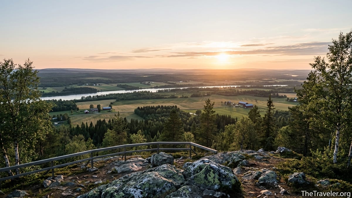
Aavasaksa Is Not a Remote Wilderness Peak
First-time visitors often imagine Aavasaksa as an isolated mountain that requires a long hike. In fact, it is a 242 meter hill with an asphalt road almost all the way to the observation tower, about 12 to 13 kilometers north of Ylitornio’s center in the Tornio River valley. Aavasaksa is tree covered and surrounded by farms, cottages and roads, not endless barren tundra. You can drive close to the top in a regular rental car and walk the last few hundred meters on a paved or gravel path.
This does not make the place less impressive. The hill rises sharply above low-lying river country, so the views across Finland and Sweden feel more dramatic than the modest elevation suggests. On a clear day, you look west over the Torne River into Sweden and east over the smaller Tengeliö River and forested ridges. Aavasaksa was one of Finland’s earliest tourist destinations precisely because it offered such a wide panorama without demanding an expedition-level trek.
The infrastructure surprises many nature-focused travelers. Near the top you may find holiday cottages, a small ski slope, parking areas and maintained nature trails. In winter, local families come to ski rather than to seek solitude. In summer, buses or tour groups sometimes come up for the view. If you are expecting a roadless fell with only a faint path and no built structures, you may be disappointed. If you frame Aavasaksa as a scenic, culturally significant hill in a settled river valley, it makes far more sense.
The Midnight Sun Here Is Subtle, Not Spectacular Every Night
Aavasaksa is frequently marketed as the southernmost place in Finland where the midnight sun is visible. That statement is technically and historically interesting, but it misleads many travelers about what they will see. The hill sits just south of the Arctic Circle, so the sun barely dips toward the horizon at midsummer, and local topography and weather matter a lot. On some nights around the June solstice you may see the sun skim the horizon without setting. On others, low clouds or haze may hide the disk although the night remains bright.
Travelers sometimes plan a short stop, arriving from Rovaniemi or Tornio late in the evening and expecting a dramatic scene like in northern Norway. In reality, the experience can be very gentle: a slow, golden arc that slides almost horizontally across the sky, with the landscape bathed in pale light around midnight. You might stand on the observation platform, look toward Sweden and see tractors still parked in fields and the river shining, but without the sun itself clearly visible.
The timing also catches people off guard. The most reliable window for a true midnight sun effect is roughly from mid June to very early July, and even then the exact conditions vary year by year. Outside that period, especially from early August onward, you still get long luminous evenings, but the sun will set and you cannot count on a “sun-at-midnight” photograph. Many visitors leave reviews remarking that the night was beautiful but not the spectacle they imagined. Planning two or three nights in the Tornio Valley, instead of a single midnight dash, gives you better odds and lowers the pressure.
Weather, Light and Seasonality Shape Almost Everything
Because Aavasaksa is low and near a wide river valley, the weather can be more humid and variable than travelers expect from Lapland. In summer, haze from warm days along the rivers can soften distant views even when the sky above is clear. Locals know that the clearest panorama often comes right after a rain front passes, when the air is washed clean. If you have a flexible schedule, timing your visit for a post-rain evening or a crisp, slightly windy day can make the difference between seeing only nearby forests and spotting distant ridges deep in Lapland.
Winter brings a completely different mood. The hill has a ski slope and is used by local skiers and snowboarders, and the forest trails become snow-covered routes where snowshoes or touring skis are practical. Travelers expecting dramatic mountain terrain should understand that the slope is modest and largely aimed at locals and families. However, the combination of low winter sun, frozen river below and frost-covered trees can be striking, especially on extremely cold, clear days when temperatures in the Tornio Valley drop well below freezing and ice fog may linger over the river while the hill stands in sunshine.
Autumn is underrated. From late September into early October, birch and aspen around the hill turn yellow and orange, contrasting with dark green spruce and pine. Night temperatures can drop close to freezing, and the first thin snow sometimes arrives on the summit while the valley still shows autumn colors. Because this period sits outside the peak summer vacation season, services like cafes or hilltop attractions may run on reduced hours or close for the season. Travelers who come specifically for foliage and quiet trails should bring their own snacks and expect self-guided experiences without much on-site staff presence.
The History on the Hill Is Deeper Than the Viewpoints Suggest
Many visitors drive up, take photos and leave without realizing they are standing on ground tied to several centuries of scientific and political history. In the 1730s, the French astronomer Pierre Louis Moreau de Maupertuis used high points in the Tornio Valley, including Aavasaksa, for a geodetic expedition that measured the length of a segment of the Earth’s meridian. Later, the Struve Geodetic Arc, a chain of survey points stretching from the Black Sea to the Arctic, also used the summit. A UNESCO World Heritage designation now recognizes these measurement points, and a plaque near the observation tower explains the story.
Because the Struve station point itself lies beneath or next to modern structures, it can be easy to overlook. Information boards around the summit in Finnish, Swedish and English interpret the history of scientific measurements, the Tornio region and early tourism. If you walk from the Kruununpuisto gate along the nature trail instead of driving directly to the tower, you pass several of these boards, small monuments and viewpoints. Doing the short walk rather than just parking at the top often gives a much richer sense of what Aavasaksa has meant to explorers, surveyors and tourists over time.
The decorative log building known as the Imperial Lodge, or Keisarinmaja, is another detail many people misinterpret. It looks like an old royal hunting cabin, and in a sense it is, but its story is more complicated. Construction began in the 19th century as part of plans related to an anticipated visit by the Russian emperor Alexander II. Political events meant the visit never happened, and the building eventually became part of local tourism history. Today, it typically opens only in summer, sometimes hosting exhibitions or special events, and remains closed outside the main season. Travelers who arrive in September or winter often see it only from the outside and are surprised that a seemingly central feature is locked.
Services Are Scattered and Often Seasonal
One of the most common practical surprises is how limited the services are right on the hill, even though Aavasaksa is a well-known destination. Close to the summit you will usually find a parking area, information boards, trails, an observation tower, and sometimes a seasonal cafe or small kiosk, depending on the year. However, there is no large supermarket or chain restaurant at the top. Most everyday services are in Ylitornio’s center or in small roadside businesses along the main road in the valley.
Accommodation is available around Aavasaksa but it is spread among several providers. Holiday villages such as Aava Sky Village and other cottage clusters operate on or near the hillside with cabins, rooms and space for campers, while separate businesses in the wider Ylitornio area offer lakeside cottages, small hotels and rural guesthouses. Some advertise camping spots and caravan pitches with basic facilities like showers, electricity and shared kitchens. A few more budget-oriented options, including simple camping areas and small cabins, can be found within a half-hour drive north along the Tornio Valley.
The key detail many travelers do not realize is that booking patterns and opening seasons follow both Finnish holiday rhythms and local demand. Some cottage complexes and campgrounds open from late spring through early autumn and close for the quiet shoulder seasons. Others focus on winter travelers who come for snow activities. If you plan to arrive in May before the main season or in late September after domestic holidays, you should not assume that camp reception desks or hilltop services will be staffed. Contacting accommodations in advance and double-checking arrival instructions is important, especially if you expect late-night check in while driving under the midnight sun.
Aavasaksa Sits Next to an International Border You Barely Notice
The Tornio River that you see from the summit doubles as the border between Finland and Sweden. From above, it looks like a broad, calm river lined with fields and villages on both sides. In practice, this means that Aavasaksa is part of a lightly populated but binational area: Ylitornio on the Finnish side faces Övertorneå in Sweden, connected by bridges and everyday cross-border traffic. Travelers with a rental car can drive across the river in a matter of minutes, moving between time zones and languages almost without any border formality.
What tends to surprise visitors is how seamless, yet slightly confusing, this border can be. On the Finnish side you pay in euros, while on the Swedish side it is Swedish kronor. Supermarkets, gas stations and cafes may be marginally cheaper for some items on one side than the other, depending on fuel prices and promotions at the time. Road signage shifts from Finnish and Swedish to Swedish only, and speed limits change to match Swedish norms. If you use a navigation app, you may see times jump by an hour when you cross, because Sweden is in Central European Time while Finland is in Eastern European Time.
Another subtle challenge is that some accommodation and activity listings use place names in either language, sometimes for the same village. For example, you might see a cottage described as being in “Aavasaksa, Lapland” or “Ylitornio” or the Swedish “Övertorneå region,” even though the actual drive from the hilltop parking to the property takes only ten to fifteen minutes. When planning your stay, check approximate distances in kilometers rather than relying only on regional labels. This matters in winter, when icy roads or snow reduce driving speeds, and in summer, when late-night fog over the river can reduce visibility even though the sky is bright.
Local Culture and Everyday Life Are Part of the Experience
Unlike purpose-built resort areas, Aavasaksa sits within an agricultural and cross-border community that existed long before tourism. From the hill you look down on fields, barns and riverside homes, and if you drive through the valley you see tractors, hay bales and small village shops. For many locals, the hill is where you take visiting relatives to see the view or celebrate Midsummer, not just a tourist icon. Mid June gatherings at the summit, with bonfires, food stalls and music, remain a cherished tradition in years when events are organized, and visitors who happen to be in the area at that time sometimes find themselves sharing the viewpoint with families in wool sweaters, not only cameras on tripods.
The Tornio Valley is bilingual and bicultural. Finnish and Swedish have long mixed here, and many people speak both languages as well as English. Restaurants and cafes in Ylitornio and across the border in Övertorneå may serve classic Lapland dishes such as reindeer stew with mashed potatoes, salmon from local rivers and berry-based desserts in berry season. You may also find everyday grill kiosks serving hamburgers and sausages, and grocery stores that stock local cheeses and breads. Travelers sometimes assume that Lapland always equals Sami culture on display, but in Aavasaksa and Ylitornio the visible identity leans more toward river valley farming and Finnish-Swedish border life.
One underappreciated aspect is how quiet the region can feel outside peak weekends. Even in summer, you may stand on the summit on a Tuesday evening and share the entire view with only a handful of people. Down in the valley, however, life goes on: school buses, grocery runs, commuting to jobs. Embracing this mix of everyday routines and grand landscape often makes for a more rewarding visit than chasing a postcard moment. Walking the nature trails, stopping at a village cafe, or visiting a small local museum or church can give more context to the panorama you admire from above.
Practical Challenges: Transport, Food and Navigation
Because Aavasaksa lies away from the busiest tourist corridors, transport can be trickier than casual maps suggest. Public buses exist along the Tornio Valley, connecting towns like Tornio, Pello and Ylitornio, but frequencies are limited and schedules may not match late-night midnight sun outings. For most travelers, especially those coming from Rovaniemi or Kemi-Tornio, renting a car is the most practical option. The drive from Rovaniemi to Ylitornio typically takes around two hours in normal conditions, while from Tornio it is roughly an hour, but winter snow and ice can lengthen these times.
Food access around the hill is another point where visitors get caught out. Ylitornio’s center has supermarkets, a few restaurants and lunch places that serve typical Finnish buffet lunches on weekdays. Some roadside diners and grill kiosks appear along the main road. However, these businesses may close relatively early compared to big-city expectations, especially on Sundays. If you plan to watch the midnight sun from Aavasaksa, it is wise to buy picnic supplies and water in town earlier in the day. Hilltop kiosks, when open, usually offer only a limited range of snacks, ice cream and hot drinks.
Navigation itself is not difficult but small details matter. The access road to the summit is usually signed with the Aavasaksa name, and standard navigation apps recognize the hilltop parking. However, in winter heavy snow can partly cover signs or narrow the road, and spring thaw may leave some side tracks muddy. Do not rely on satellite imagery alone to decide whether an unofficial track is passable. Sticking to the main asphalt route and designated parking lots is generally safer and more respectful of local landowners, whose driveways and forest roads sometimes look like tempting shortcuts.
The Takeaway
Aavasaksa is not the most extreme summit in Lapland, nor the largest ski area, nor the most famous midnight sun viewpoint. Its appeal lies in a specific mix of qualities: scientific and historical heritage on a low hill, expansive views over a cross-border river valley, and the quiet rhythm of local life in and around Ylitornio. Many visitors arrive expecting a remote Arctic mountain and are surprised to find asphalt, cottages and family ski slopes. Others come for a quick photo stop and discover that a slow evening walk along the nature trail, reading information boards and watching the light change over the Torne River, is far more memorable.
If you understand the limits of the setting, plan for patchy services and variable weather, and give yourself time to experience both the hill and the valley below, Aavasaksa becomes more than a viewpoint. It becomes a lens into how people have measured, imagined and lived with this landscape for centuries, from French astronomers and Russian-era planners to today’s farmers and cross-border commuters. Arriving prepared for subtlety rather than spectacle is the best way to let this understated Lapland landmark surprise you in the right ways.
FAQ
Q1. Where exactly is Aavasaksa and how do I get there?
Aavasaksa is a hill in the municipality of Ylitornio in Finnish Lapland, overlooking the Tornio River and the border with Sweden. Most travelers reach it by car, driving about an hour north from Tornio or around two hours northwest from Rovaniemi. There is an asphalt road up the hill with signposts leading to a parking area near the summit.
Q2. Do I need hiking experience or special gear to visit the top?
No. In summer, the summit is accessible by car almost all the way, and the last section can be walked on paved or well maintained paths. Sturdy shoes are useful but technical gear is not required. In winter, if you want to explore forest trails beyond the immediate summit area, snowshoes or skis and appropriate cold weather clothing are recommended.
Q3. When is the best time to see the midnight sun at Aavasaksa?
The best chance to see a true midnight sun effect is around the June solstice, roughly from mid June to very early July, when the nights are brightest. Even then, cloud cover or haze may hide the sun itself, so having two or three nights in the area improves your chances. Outside this window, you still get long light evenings but the sun will eventually set.
Q4. Are there places to stay overnight near Aavasaksa?
Yes. There are cottage villages and small holiday resorts on and around the hill that offer cabins, rooms and camping or caravan spots, as well as additional guesthouses and small hotels in the wider Ylitornio area. Because many of these are seasonal and have limited staff, advance booking and confirming arrival details is strongly recommended.
Q5. What services are available at the top of the hill?
At the summit you will usually find parking, marked paths, an observation tower and information boards. In the main summer season there may be a small cafe or kiosk offering drinks and snacks. There are no large supermarkets or full service restaurants at the top, so most visitors bring food and water from Ylitornio or nearby villages.
Q6. Can I visit Aavasaksa in winter and is it worth it?
Yes, you can visit in winter, and the hill has a small ski slope used by locals. The atmosphere is very different from summer, with snow covered forests, low winter sun and views over a frozen river. Road conditions, limited daylight and cold temperatures make planning more important, but on clear days the winter landscape can be striking.
Q7. Is Aavasaksa suitable for families with children?
For many families, Aavasaksa works well. The drive up reduces the amount of walking needed, and the main paths near the top are short and not technically difficult. Children often enjoy the observation tower and open viewpoints. Parents should supervise kids near steep edges, on the ski slope area in winter and when traffic is present on the summit road.
Q8. How does the Finland–Sweden border affect a visit?
The hill overlooks the Tornio River, which marks the border between Finland and Sweden. You can easily drive across nearby bridges between Ylitornio and Övertorneå. The border is open within the Schengen Area, but currencies and time zones differ, so you switch from euros to Swedish kronor and from Finnish time to Central European Time when you cross.
Q9. Are there marked hiking trails around Aavasaksa?
Yes. Short nature trails loop around the hill, starting from areas such as the Kruununpuisto gate and leading past viewpoints, information boards and forest sections. These are suitable for casual walking rather than long-distance trekking, and most visitors can complete them in an hour or two. Trail conditions vary by season, so footwear with good grip is helpful.
Q10. Do I need to worry about wildlife or insects?
In summer, mosquitoes and other biting insects can be noticeable, especially in forested and damp areas, so insect repellent and long sleeves are helpful. Larger wildlife such as reindeer may be seen near roads or trails but generally do not cause problems if given space. Standard precautions, such as watching for animals on the road while driving, are usually sufficient.