
Culver Down rises in a clean white arc above Sandown Bay on the Isle of Wight’s east coast, a chalk ridge where sea cliffs, open grassland, and half-buried fortifications all compete for attention. It is one of the island’s most rewarding short excursions, combining big coastal views, easy but spectacular walking, and a surprisingly dense cluster of stories, from Tudor skirmishes with the French to massive gun batteries hidden in the turf. This guide explains how to get there, what you will see on the main viewpoints and walks, and how to spot the traces of the down’s hidden history beneath your feet.
Getting Oriented: What and Where is Culver Down?
Culver Down is a chalk headland and ridge on the eastern side of the Isle of Wight, just north of Sandown and Yaverland and west of Bembridge. Rising to around 90 metres above sea level, it forms the eastern end of Sandown Bay and marks a dramatic bend in the coastline as the cliffs swing round towards Whitecliff Bay and Bembridge. The public downland is owned and managed by the National Trust, which helps to keep it largely open and undeveloped, with free access on foot from dawn to dusk.
On a map, you will see Culver Down labelled just east of Sandown, connected by a single-track lane that climbs steeply from the B3395 between Yaverland and Bembridge. At the top, a scattering of free car parks, a pub and seasonal refreshment van, interpretation boards and a line of footpaths mark the main access points. The Isle of Wight Coast Path crosses the down, so long-distance walkers pass this way en route between Sandown and Bembridge or further towards Ryde.
For visitors based in the island’s main resorts, Culver Down is especially convenient. From Sandown seafront it is roughly 3 kilometres to the top if you walk via Yaverland and the coastal path, a popular half-day outing. From Bembridge, a slightly longer but gentler approach follows tracks and quiet roads up onto the ridge. However you reach it, the reward is the same: a wide, grassy plateau with uninterrupted 180-degree views of sea and sky.
Although it feels wild, Culver Down is not remote in a mountaineering sense. Mobile signal is generally good, there are clear waymarked paths, and you are never far from a road or village. That makes it a comfortable destination for families, casual walkers and anyone who wants big scenery without committing to a long or technical hike.
Reaching the Ridge: Practical Access and Parking
Most visitors arrive at Culver Down by car via the narrow lane signed from the B3395 between Yaverland and Bembridge. The road climbs quickly in a series of bends, including a sharp hairpin, before emerging onto the open grassland. Here you will find several small free car parks spaced along the top of the ridge near Bembridge Fort and the Yarborough Monument. These car parks are unstaffed and have no time limits during the day, but overnight parking is not permitted and there are no dedicated motorhome facilities.
If you would rather leave the car behind, there are good public transport options. Southern Vectis bus services along the east coast typically stop at Yaverland and Bembridge, from where you can walk up to the down. From Yaverland, expect a strenuous but short climb: it is around 1.5 kilometres from the beach car park to the top, following the coast path up the cliff. From Bembridge, you can follow local footpaths and quiet lanes, picking up signs to Bembridge Down and the fort. Using the bus for one leg and walking back over the downs is a popular way to do a one-way hike without retracing your steps.
Cyclists often include Culver Down in circular rides from Shanklin or Ryde. The approach lane is steep and narrow, so traffic awareness is vital, but once on the ridge the tarmac access road and grassy tracks give a relaxed ride, with the option to freewheel down to Bembridge or Yaverland at the end. For road cyclists, Culver is one of the more memorable short climbs on the island, comparable in effort to the better-known ascent of Blackgang on the south coast but with different views.
Facilities on the down itself are simple. There are no formal visitor centres or permanent toilets on the ridge, so plan to use facilities in Sandown, Bembridge or at local pubs before or after your walk. The popular Culver Haven Inn near the top offers meals, drinks and toilets for customers, and there is often an ice cream or snack van in fine weather near one of the car parks, especially in school holidays and on sunny weekends in late spring and summer.
The Classic Viewpoints: What You Will See from the Top
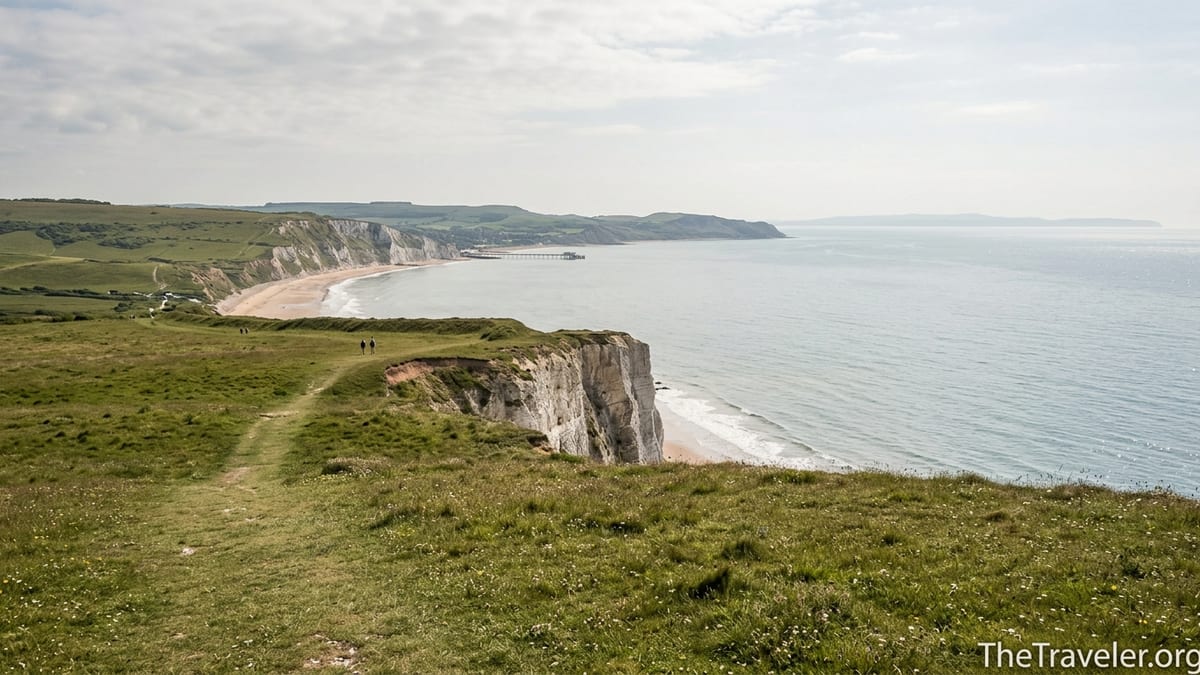
The main reason people come to Culver Down is the view. On a clear day, you can see across the broad curve of Sandown Bay, down to Shanklin and Luccombe and, in the other direction, over the Solent towards Portsmouth and the mainland. The sweep of chalk cliffs, backed by green downs and fronted by a pale sand beach and turquoise water on sunny days, is one of the Isle of Wight’s most recognisable vistas.
From the car parks near the Yarborough Monument, short grassy paths lead towards the cliff edge, where low earth banks and informal desire lines mark favourite vantage points. Looking west, your eye follows the arc of Sandown’s seafront, dotted with beach huts and the pier, then beyond to the wooded chine at Shanklin and the more rugged southern headlands. In the foreground, seabirds wheel on the updrafts, and in summer you may see paragliders launching from the down, their colourful canopies standing out against the white cliffs.
Turn north and east, and the scene changes. You look over the low-lying wetlands and fields around Brading Haven and Bembridge, with the distinctive long arm of Bembridge Harbour’s sea wall and marina visible at low tide. Beyond that lie the Solent’s busy shipping lanes and the outline of Portsmouth, with its Spinnaker Tower often visible as a spike on the horizon. On hazy days the mainland softens to a blue-grey band, but even then you can often pick out passing ferries and cargo ships with binoculars.
Sunset and late afternoon light can be spectacular here. Although the headland faces broadly east and south, the low sun often washes across the bay from the side, picking out the chalk cliffs in soft gold and casting long shadows across the downland. In winter, when the atmosphere is clear after cold fronts, photographers frequently climb up in the late afternoon for shots of the bay while the towns below switch on their lights. Conversely, early risers in midsummer sometimes catch the first glow over Whitecliff Bay and the English Channel, especially on still, high-pressure mornings.
Walking Culver Down: Short Circuits and Coastal Routes
For a first visit, one of the best options is the waymarked loop sometimes described as the “Circumnavigate Culver Down” walk, which begins and ends at the National Trust car park by Bembridge Fort. The route is about 4.5 kilometres and typically takes between 1.5 and 2 hours at a leisurely pace. It follows open grassy paths along the top of the cliffs, circles around the Yarborough Monument, and skirts the edge of the fort before returning via inland tracks. There are modest gradients and some uneven sections, but no prolonged steep climbs once you are on the ridge.
More energetic walkers often link Culver Down to longer coastal routes. One popular outing is the hike from Sandown Pier to Culver Down and on to Bembridge Lifeboat Station. Starting at the pier, you walk north along the promenade to Yaverland, climb the coast path up the cliffs, traverse the top of Culver with pauses for photos, then descend via field paths and minor roads to the lifeboat station and Bembridge beach. Depending on the exact line you take, this makes a walk of roughly 8 to 10 kilometres. Many walkers then catch a bus back to Sandown, or continue along the coastal path towards St Helens and Ryde.
For those tackling the wider Isle of Wight Coast Path over several days, Culver is a natural and memorable section between Shanklin or Sandown and Ryde. Guidebook descriptions typically highlight the contrast between the airy clifftop segment over Culver and the more sheltered stretches along the seawalls near Brading Marshes and Seaview. Because the ridge is quite exposed, it feels dramatically different depending on the weather: in strong southwesterlies you will be buffeted by wind and spray, while on calm summer days the sea below can look almost Mediterranean.
If you prefer a gentler amble, staying on top of the plateau works well. Families with children often park near the monument and simply follow the grass paths that circle it, letting youngsters run ahead while adults enjoy the views. It is easy to tailor the length of your walk to the time and energy you have: even a 20-minute stroll along the edge and back can be rewarding, whereas walkers keen to rack up steps can link multiple loops together, perhaps including an exploration of the Culver Battery ruins at the far eastern end of the headland.
Hidden History: Forts, Batteries and Old Invasions
For such a peaceful place, Culver Down has a surprisingly martial past. Its height and position overlooking the eastern approaches to the Solent made it a natural site for coastal defences. The most obvious of these today is Culver Battery, a former coastal artillery battery dating from the early 20th century. Built in the years leading up to the First World War and later modified, it once mounted heavy 9.2-inch guns whose role was to deter enemy warships from threatening the naval base at Portsmouth or the island’s own anchorages.
The battery closed in the 1950s and its guns were removed, but the concrete emplacements, magazines, tunnels and observation posts remain, slowly softening under grass and scrub. Self-guided visitors can wander the ruins on an informal basis, picking out the big circular gun pits, ammunition hoists and shell stores. Information boards in and around the site help you imagine how it functioned during both world wars, when gunners, signallers and engineers would have worked here around the clock, scanning the eastern Channel for hostile silhouettes.
West of the battery and slightly inland is Bembridge Fort, a polygonal Victorian fortification constructed in the 1860s during a period of anxiety about French naval power. It was one of a chain of so-called Palmerston Forts that ringed the Isle of Wight and the Solent. From the outside, it appears as a low, grassed-over mound with brick caponiers and a dry moat. The interior is usually accessible only on certain days via organised tours, typically offered in the summer season, so it is worth checking locally if you hope to explore inside. Even if you remain outside, walking around the ramparts gives a strong sense of the island’s 19th-century defense strategy.
Culver’s military history runs back much further. In the mid 16th century, the down was the scene of a skirmish between local forces and French troops who had landed nearby and were attempting to push inland towards Sandown. Accounts suggest that Isle of Wight levies, including men led by local landowners, intercepted the raiding party on the high ground of the down and forced them back towards the beach. Later centuries saw further fortifications along this coast, including Redcliff Battery nearer Yaverland, whose remnants can still be spotted from the coastal path as concrete and brick shapes half swallowed by the cliffs.
Nature on the Edge: Wildlife, Seasons and Weather
Beyond the forts and views, Culver Down is valued for its wildlife and chalk grassland habitats. The wind-clipped turf supports wildflowers such as cowslips, thyme and various orchids in late spring and early summer. Standing on the ridge in May or June, you may see yellow swathes of birds-foot trefoil and patches of pink thrift near the cliff edges. Insects respond in kind: on warm days the sward can be alive with butterflies, including common blues and marbled whites, and you may notice the hum of bees working the low flowers.
Birdlife is another highlight. The cliffs hold nesting seabirds, and raptors such as kestrels and peregrine falcons frequently patrol the updrafts along the escarpment, hovering or stooping on unsuspecting prey. Corvids, including ravens and jackdaws, often tumble in the wind above the Yarborough Monument. In late autumn and winter, migratory species pass through, and you might see skeins of geese or flocks of thrushes moving along the coast. Birdwatchers often combine an hour on the down with a visit to the RSPB reserve at nearby Brading Marshes, which occupies the reclaimed former harbour below.
The weather on Culver Down is a character in its own right. Because the ridge is relatively exposed, conditions can change quickly. A summer day on the beach at Sandown can feel hot and still, but ten minutes later on the top you may need a windproof jacket to be comfortable. In winter, the wind chill can be significant, especially in northerly or easterly winds that blow across the Solent. Visitors who arrive in flip-flops and light clothes sometimes cut visits short once they feel the breeze, so packing an extra layer and sturdy footwear is a wise precaution even on apparently benign days.
The flip side of that exposure is the clarity of the air after Atlantic fronts pass through. On such days, visibility can extend for many tens of kilometres, and locals love pointing out individual landmarks across the water: the shape of the Spinnaker Tower, the towers of Portsmouth’s dockyard, or even the hazy outline of the South Downs inland from the coast. After dark, the down feels remote and wide open, with relatively little light pollution compared to the towns below, and on clear nights stargazers sometimes bring telescopes up to the car parks to enjoy the sky views.
Family-Friendly Experiences and Safety on the Cliffs
With its combination of grassy open spaces, short walks and wide views, Culver Down is an easy recommendation for families visiting the Isle of Wight. Children can run freely on the turf, fly kites in the reliable breeze and peer over safe set-back viewpoints at the cliffs below. Picnic rugs are a common sight on summer weekends, especially between the Yarborough Monument and the main car parks, where the ground is relatively even and the nearest drop-offs are set back beyond fences or banks.
At the same time, this is a genuine clifftop environment, and a few simple precautions make visits safer and more relaxed. Several unprotected cliff edges and overhangs exist, especially along informal desire lines where people have created paths closer to the brink. Keeping younger children within arm’s reach near the edge, avoiding wet or muddy slopes, and steering well clear of any areas where the ground appears undercut or cracked are sensible habits. Warning signs and occasional fenced sections remind visitors of the dangers of erosion, but they cannot cover every potential hazard.
For dog owners, Culver Down is a treat. Dogs are welcome across the downs, and you will see many local walkers out with their pets at all times of year. However, livestock is sometimes grazed on the grassland to help maintain the habitat, so keeping dogs on a short lead around cattle or ponies and under close control elsewhere is important. In summer, the combination of heat and exertion can be hard on older dogs, so bringing water and checking paws for irritation from dry, rough turf after walks can help avoid problems.
Footwear and clothing choices can also shape your experience. Even if you only plan to wander a kilometre or two from the car, trainers or walking shoes with decent grip are preferable to sandals on the often uneven, rabbit-holed ground. After rain, the clay-rich soils on parts of the paths can become slippery, especially on the steeper slopes near the coastal path descents. A light waterproof or windproof jacket, a sunhat in high summer, and sunscreen round out a sensible kit list for most days on the down.
Food, Drink and Combining Culver with Nearby Attractions
Many visitors time their walk on Culver Down to coincide with a meal or drink stop. The Culver Haven Inn, close to the top of the access lane, serves typical pub dishes such as fish and chips, pies and burgers, along with local ales and soft drinks. On a practical level, it offers a convenient refuge when the weather turns and a cosy spot to warm up after a winter stroll. In fine weather, its outdoor seating can be a pleasant place to linger over lunch while the wind whistles across the ridge above.
If you prefer a picnic, the grassy slopes between the monument and the cliff edge offer dozens of informal spots to spread a blanket. On busy summer days, local families often arrive with cool boxes, folding chairs and simple games for children, turning the down into an elevated park-with-a-view. Because there are no bins every few metres, packing rubbish home and using the limited waste facilities near the car parks helps keep the area clean and reduces problems with windblown litter.
Culver Down also fits easily into a wider day out on this side of the island. A common combination is to spend the morning on the beach at Yaverland or Sandown, then drive or walk up to Culver in the afternoon for a change of perspective and cooler air. Alternatively, visitors might explore Bembridge’s harbour, lifeboat station and coastal cafes, then loop up to the fort and down for sunset. On less beach-friendly days with broken cloud and fresher winds, the open downland can actually feel more appealing than being on the sand.
Nearby attractions cater to a range of interests. History enthusiasts can pair a circuit of Culver’s fortifications with a visit to Brading Roman Villa, a well-presented archaeological site a short drive inland that showcases some of Britain’s best preserved Roman mosaics. Wildlife lovers might follow time on the down with a walk around the marshes below, looking for wading birds and raptors. Active visitors can extend a Culver hike into a longer route that also takes in Bembridge Windmill or the wooded slopes behind Shanklin, using local guidebooks or downloadable route descriptions as a planning aid.
FAQ
Q1. How long does it take to walk around Culver Down?
Most visitors allow about 1.5 to 2 hours for a full circuit from the main car park near Bembridge Fort, covering roughly 4 to 5 kilometres at a relaxed pace.
Q2. Is Culver Down suitable for young children and pushchairs?
The open grassy areas near the car parks are fine for young children, but most paths are uneven and include slopes, making them challenging for standard pushchairs.
Q3. Can I reach Culver Down without a car?
Yes. You can take a bus to Sandown, Yaverland or Bembridge and then walk up using signed footpaths and the Isle of Wight Coast Path; expect a short, steep climb.
Q4. Are there toilets and other facilities on Culver Down?
There is no formal visitor centre or public toilet block on the ridge itself. Facilities are available in nearby towns and at local pubs for customers.
Q5. Is it safe to walk dogs on Culver Down?
Dogs are welcome and it is a popular dog-walking area. Keep them on a short lead around livestock and away from unprotected cliff edges and steep slopes.
Q6. Do I need special walking equipment?
For most visits, sturdy shoes or trainers with grip, a windproof or waterproof jacket, and seasonal sun or cold protection are sufficient; no technical gear is needed.
Q7. Can I visit Culver Battery and Bembridge Fort?
Culver Battery is freely accessible as a ruin for self-guided exploration. Bembridge Fort usually opens only on specific days or by guided tour, mainly in summer.
Q8. Is wild camping allowed on Culver Down?
No. Overnight parking and camping are not permitted on the down, both to protect wildlife and because the land is actively managed by conservation bodies.
Q9. When is the best time of year to visit for views and wildlife?
Late spring and early summer offer wildflowers and butterflies, while clear winter days can give the sharpest long-distance views across the Solent and along the coast.
Q10. How exposed is Culver Down to wind and weather?
The ridge is quite exposed, so it often feels windier and cooler than the beaches below. Always bring an extra layer and be prepared for rapid weather changes.