
More news on this day
A sprawling late-season winter storm is unleashing blizzard conditions from the Upper Midwest to the Northeast, snarling air and rail networks in Chicago, New York, Boston, Minneapolis and other major hubs while hazardous roads and whiteout conditions leave thousands of travelers stranded across a broad swath of the United States.
Get the latest news straight to your inbox!
Major Hubs Crippled as Storm Tracks from Midwest to Northeast
The current storm, tied to a large extratropical cyclone sweeping across the central and eastern United States, is packing heavy, wind-driven snow that has rapidly reduced visibility and created treacherous conditions on runways and highways alike. Forecast discussions describe a classic late-winter setup, with deepening low pressure drawing moisture into Arctic air over the northern tier of the country, producing intense snowfall bands and gusty winds.
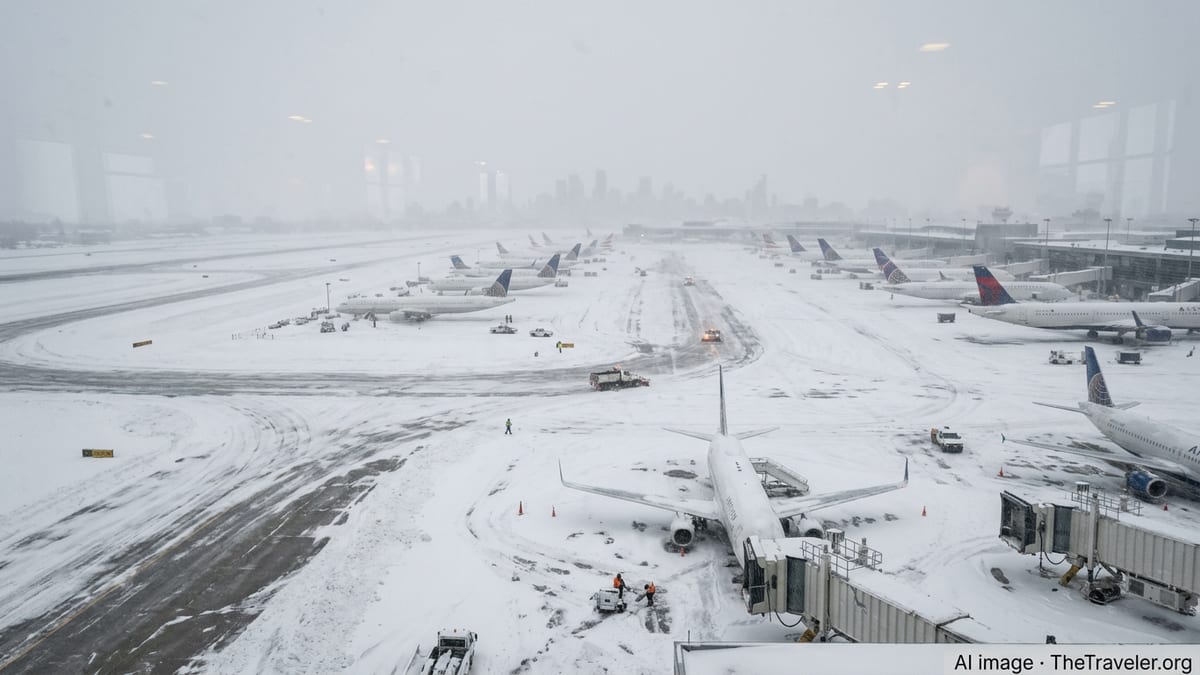
Chicago is facing some of the most disruptive impacts in the Midwest as the storm pivots through the Great Lakes region. O’Hare and Midway have reported periods of near-zero visibility, with plow crews struggling to keep up as fresh snow is blown back across cleared pavement. Reports from airline trackers and airport status boards indicate hundreds of flight cancellations and rolling delays, affecting connections nationwide.
As the system pushes east, the same circulation is reinforcing winter conditions in New York and Boston, where residents are still digging out from the historic Blizzard of 2026 that brought several feet of snow and rare travel bans just weeks earlier. Publicly available information from weather services and media outlets notes that the renewed blizzard conditions are compounding existing snowpack, shrinking roadways and limiting space for additional snow removal in dense urban neighborhoods.
Farther north and west, Minneapolis and other Upper Midwest cities are contending with strong winds over fresh, powdery snow, producing ground blizzards that can shut down interstates even when new snowfall rates begin to taper. Regional reports describe long stretches of rural highway reduced to one lane by drifts, with plows forced to make repeated passes as visibility fluctuates between marginal and extremely poor.
Thousands of Travelers Stranded as Flights and Trains Grind to a Halt
Across the storm zone, the combined effect of multiple recent winter systems has left transportation networks with little room for error. The latest blizzard arrives on the heels of the February 2026 nor’easter that triggered more than nine thousand flight cancellations in the Northeast and Mid-Atlantic and disrupted travel for days. Many carriers are still operating on tighter schedules as aircraft and crew rotations recover from that earlier event.
Airline status dashboards and aviation tracking services now show another wave of mass disruptions. At Chicago O’Hare, New York’s major airports and Boston Logan, airlines have proactively scrubbed large portions of their schedules as crosswinds strengthen and runway conditions deteriorate. Connections through Minneapolis–Saint Paul are also heavily affected, with reports indicating aircraft and crews out of position due to earlier weather in the northern Plains and Great Lakes.
For passengers already on the move, this has translated into crowded concourses, lengthy rebooking lines and, in many cases, overnight stays in terminals as hotels near major airports quickly fill. Social media posts and local news coverage highlight travelers sleeping in gate areas and baggage halls in Chicago and New York, reflecting both the scale of cancellations and the difficulty of rerouting around such a wide-reaching storm.
Rail passengers have fared little better. Amtrak and regional rail providers have reduced or suspended service on key corridors where blowing and drifting snow clogs track switches and obscures signals. In some metropolitan areas, commuter rail and light rail systems are running on limited or weekend schedules, with agencies citing snow-packed crossings and reduced staff availability as crews are reassigned to storm response.
Hazardous Roads and Power Outages Add to Travel Risks
On the ground, the blizzard’s most immediate impact is being felt along highways and local roadways as bands of heavy snow sweep repeatedly over the same regions. State departments of transportation from the upper Midwest through New England have issued advisories against nonessential travel, citing slick conditions, rapidly forming drifts and the potential for stranded vehicles to slow emergency response.
In and around Chicago, lake-enhanced snow is intensifying totals near the shoreline, creating sharp gradients in accumulation over short distances. Publicly available traffic camera feeds and regional media images show vehicles creeping along partially cleared expressways, with hazard lights illuminating a low-contrast landscape. Similar scenes are playing out on interstates leading into Minneapolis, where strong crosswinds blow snow across open farmland and into deep drifts along the road shoulders.
As the storm interacts with milder air closer to the Atlantic, parts of the New York metropolitan area and southern New England are also dealing with mixed precipitation and ice. Forecasters have warned that brief periods of sleet and freezing rain could worsen driving conditions by glazing over packed snow, especially on bridges, overpasses and untreated secondary roads. This adds another layer of risk for those attempting to reach airports or rail stations during narrow lulls in the snowfall.
Power reliability is an additional concern in several states. The combination of heavy, wet snow and gusty winds has begun to bring down tree limbs and power lines in pockets of the affected region, according to utility status pages and local reporting. Outages complicate travel by darkening intersections, disrupting traffic signals and limiting fuel availability at some gas stations, while also forcing stranded travelers to seek warm shelter in public facilities.
Ripple Effects for Spring Break and Business Travel
The timing of this storm is particularly disruptive, coinciding with a busy period for spring break and late-winter business travel. Many schools and universities in the Midwest and Northeast are entering or returning from holiday periods, and tourism-focused destinations are heavily dependent on the smooth functioning of hub airports in Chicago, New York, Boston and Minneapolis.
Travel industry analysts note that the cumulative effect of repeated major storms this winter is amplifying the impact of the current blizzard. The historic nor’easter that buried parts of New England in February, along with subsequent clipper systems and Arctic outbreaks, has already exhausted some travelers’ flexibility for rescheduling and increased costs for airlines, hotels and tour operators.
With aircraft and crews still cycling back into position from the February blizzard, the new wave of cancellations is expected to ripple through national and even international networks. Passengers connecting through Chicago to reach West Coast or European destinations, or through New York and Boston to reach transatlantic and Caribbean routes, are likely to face multi-day delays or forced itinerary changes.
Business travelers are also feeling the strain. Conference and convention organizers in major cities report declining in-person attendance as participants opt to join virtually rather than risk being stranded in transit. In some cases, smaller regional meetings have been postponed or moved entirely online due to uncertainty around road and air conditions in the coming days.
Travelers Urged to Monitor Conditions and Expect Prolonged Disruptions
Forecast guidance suggests that while the most intense snowfall rates will eventually shift eastward or weaken, strong winds and cold temperatures will persist behind the storm’s center. This means that even after the heaviest bands move on from cities like Chicago, Minneapolis, New York and Boston, blowing and drifting snow may continue to affect visibility and prolong cleanup efforts.
Publicly available information from national and regional weather services emphasizes that recovery from such a widespread storm is rarely immediate. Runways, taxiways, rail lines and highways require extensive plowing and de-icing before normal operations can resume, and transportation providers must carefully sequence the return of equipment and staff to avoid compounding delays.
Travel experts recommend that anyone planning to move through the affected corridor in the coming days build in significant flexibility. Guidance widely shared by airlines and meteorologists urges travelers to confirm the status of flights, trains and buses before leaving home, allow extra time for security and boarding, and prepare for the possibility of last-minute changes as conditions evolve.
For those already on the road, officials and transportation agencies are steering drivers toward caution and patience as crews work around the clock to restore safe mobility. With deep snowpack lingering from earlier storms and another major system now reinforcing winter’s grip, much of the northern United States is bracing for several more days of disrupted travel before networks can fully recover.