


Dettifoss and Selfoss sit a short distance apart on the glacial Jökulsá á Fjöllum river in the Jökulsárgljúfur sector of Vatnajökull National Park. Most travelers experience them together on foot from a parking area on either the west or east bank, then follow waymarked trails to viewpoints over both falls. This guide focuses on the practical decisions you need to make once you already know you want to visit: which side of the canyon to use, how demanding the walks are, and whether it is worth investing time to see both banks.
Get the latest updates straight to your inbox!
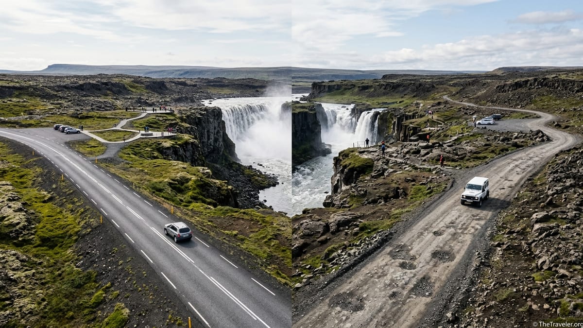
Understanding the Two Access Roads: Route 862 vs Route 864
The west side of Dettifoss and Selfoss is reached from Iceland’s Ring Road by Route 862, sometimes signed as Dettifossvegur. Over the last decade this has been rebuilt as a paved road, and current national and regional tourism information describes it as fully paved from Route 1 to the main west-bank parking area. It is the default choice for most first-time visitors because it feels similar to driving the rest of the Ring Road in summer.
The east side is accessed via Route 864, typically signed as Hólsfjallavegur. This remains an unpaved gravel road. Recent guides and visitor reports describe the surface as rough and often potholed in places, especially south of the Dettifoss turnoff. Driving is usually slower and less comfortable than on Route 862, particularly in small rental cars. Travelers must treat Route 864 as a marginal road where speed and comfort are very dependent on current maintenance and weather.
Both roads leave from the same general stretch of the Ring Road in North Iceland, between Lake Mývatn and Ásbyrgi. The exact junctions are clearly signed locally for Dettifoss and Selfoss. You should not rely solely on generic navigation apps, which sometimes mislabel sides or send drivers inefficiently back and forth. Before departure, compare your planned route with an up to date Icelandic road map and the official road condition map so you are certain which side you are targeting on the day.
Crucially, road conditions in North Iceland change from year to year and from week to week. Route 862, although paved, still sees limited winter service, and short access spurs such as the final kilometers from 862 to the west parking lot may close temporarily for snow, ice or flooding. Route 864 generally closes once winter sets in and can reopen late in spring. For 2026 and beyond, travelers must confirm the latest status through official Icelandic road information and park channels just before travel, and be ready to adjust plans if a closure affects their chosen side.
What to Expect on the West Side: Access, Facilities and Viewpoints
The west bank is today the more developed and frequently visited side of Dettifoss and Selfoss. From the Ring Road, drivers follow paved Route 862 to a signed turnoff that leads to a sizable parking area that primarily serves Dettifoss but also functions as the starting point for the walk to Selfoss. The parking lot sits back from the canyon rim on relatively level ground, with information boards and marked paths leading towards the river.
The west-side experience emphasizes infrastructure and accessibility. Recent descriptions note proper toilets at or near the main parking area, though facilities may be basic and not always staffed. There are no food outlets or fuel pumps here, so visitors should arrive with full fuel and supplies from hubs such as Reykjahlíð near Lake Mývatn or the town of Húsavík. Seasonally, portable toilets or temporary closures for cleaning are possible, so carry a backup plan and follow on-site instructions.
From the west parking area, a marked trail leads first towards Dettifoss and then continues upstream to Selfoss. Depending on pace, trail conditions and any temporary rerouting, the walk from the car park to the main Dettifoss viewpoint often takes on the order of 10 to 20 minutes each way for an average hiker. Continuing from Dettifoss to a good viewpoint of Selfoss typically adds another similar amount of time. Many official and commercial sources describe the total combined loop between parking, Dettifoss and Selfoss as roughly a couple of kilometers and around an hour of walking, but it is important to treat those figures as indicative only.
The west-bank viewpoints place you slightly above Dettifoss, looking diagonally across and down into the canyon, with the river flowing away to your right. In normal conditions you can look upstream to see Selfoss in profile, where the river drops over a broad horseshoe-shaped lip. On the ground, fences, railings and path reroutes can influence exactly which angles are officially open in a given season, so it is wise to pay attention to the latest signage and to any warnings indicating that particular rocks or cliff edges are off limits.
What to Expect on the East Side: Rougher Access and Different Angles
The east bank of Dettifoss and Selfoss offers a less developed but often more dramatic-feeling visit. Drivers leave the Ring Road onto gravel Route 864, which runs along the east side of the canyon with a signed turnoff to a parking area at Dettifoss. Travelers and local operators describe Route 864 as passable for standard two-wheel-drive vehicles in good summer conditions, provided drivers reduce speed for potholes and loose stones, but it is not recommended in winter or shoulder seasons unless official maps clearly show it as open and your rental contract allows driving on gravel roads.
The east-side parking area is smaller and facilities are simpler than on the west. Some recent sources mention basic toilet facilities, though not necessarily flush toilets or heated buildings. As on the west bank, there is no food, fuel or accommodation directly at the falls. Plan fuel stops and grocery shopping around larger settlements before committing to the gravel spur, and carry water and warm, waterproof clothing even on brighter days.
From the east parking lot, footpaths lead to several viewpoints over Dettifoss and then on towards Selfoss. Walking times are broadly similar to the west side. An average visitor in summer might take around 10 to 20 minutes to reach the main Dettifoss viewpoints and a similar period to continue to a view of Selfoss, but these are approximate ranges and can stretch considerably when trails are muddy, snow-covered or partially closed. The ground here is more uneven, with more natural rock surfaces and fewer constructed platforms, so progress can feel slower.
The appeal of the east side lies in its more frontal views of the waterfalls. At Dettifoss, some viewpoints allow you to face the waterfall more directly, watching the river plunge straight towards you into the canyon. Photographers often appreciate this angle, along with the sense of immersion in spray and mist. For Selfoss, the east side can deliver broad, head-on perspectives of the multiple cascades. However, the same cliffs and open rock that create these views also introduce hazards. You should expect fewer railings and a greater reliance on your own judgment, while still staying strictly behind any marked safety lines and respecting closures that may block former unofficial photo spots close to the rim.
Hiking Distances, Difficulty and Seasonal Conditions
For most visitors, Dettifoss and Selfoss are short hikes rather than full-day treks, but conditions in Vatnajökull National Park mean that even short distances deserve respect. On both banks, current park information and guide material suggest that the one-way walking distance from the main car parks to Dettifoss is on the order of several hundred meters, often covered in around a quarter of an hour by a reasonably fit person in dry summer weather. The continuation between Dettifoss and Selfoss is commonly described as roughly a similar distance again, making the total round trip between car park, Dettifoss and Selfoss something like a couple of kilometers.
These figures should be treated as ranges rather than promises. Trail surfaces include gravel, bedrock, mud and sections of uneven stone, which can slow progress and increase the effort required compared with a flat city sidewalk. In spring and early summer, meltwater can flood low spots; in autumn and winter, ice and packed snow may cover entire stretches. The park authority periodically reroutes paths away from eroding or unstable edges, adding slight detours that make online distance figures out of date. Always check on-site maps and allow generous time buffers, particularly if you are returning to a fixed departure such as an evening drive across the north or a guided tour.
In terms of difficulty, both the west and east paths are generally considered easy to moderate for people with normal mobility in summer, but the east side feels more rugged. Visitors with limited mobility, young children or less experience on uneven ground often find the west bank more manageable, thanks to clearer surfacing near the viewpoints and fewer large rocks to negotiate. In poor weather, wind and spray at Dettifoss can make even simple paths treacherous. Good hiking footwear with grippy soles, layered waterproof clothing and trekking poles are advisable for shoulder seasons or for anyone who feels unsteady on wet rock.
Winter transforms the character of the hikes. Snow and ice may obscure trail markers, and unofficial footprints can lead dangerously close to corniced edges. Short days mean that twilight can fall quickly on your return walk. Unless you have winter hiking experience in similar northern conditions, it is usually safer in midwinter to experience Dettifoss and Selfoss as part of an organized excursion with local guides who understand current trail and river conditions.
Walking Between Dettifoss, Selfoss and Hafragilsfoss
At a minimum, practically all independent visitors should plan to walk from their chosen parking area to Dettifoss and onward to at least one viewpoint of Selfoss. On the west side, the national park promotes a short, waymarked hiking route sometimes labeled with internal codes such as NA-15 or local trail names that cover the Dettifoss–Selfoss section. Trail markers and signposts are usually easy to follow in summer. If signage or maps show a recommended loop, that loop typically returns to the same car park via slightly different vantage points rather than continuing along the canyon indefinitely.
On the east side, paths between Dettifoss and Selfoss are less formalized but still marked in the main season. In recent years, visitors have reported temporary cordons or rope barriers where erosion or rockfall risk has led managers to close certain unofficial ledges or cut-off corners. It is essential to respect these and to stay on the signed routes, even if that means accepting a more distant or less symmetrical composition of the waterfalls than photographs from previous years suggest.
For experienced hikers, the wider Jökulsárgljúfur area offers longer canyon routes that can link Dettifoss and Selfoss with Hafragilsfoss, another impressive waterfall downstream. These longer trails may run on either bank, sometimes along the canyon rim and sometimes slightly inland. Their exact alignment and status can change with erosion, conservation needs and infrastructure upgrades. Before planning a full-day hike that connects multiple waterfalls, check the latest official Vatnajökull National Park trail descriptions, maps and any 2026 seasonal notices, and be prepared to scale back your ambitions if rangers advise against particular segments.
Note that there is no simple, marked pedestrian bridge or casual river crossing between the west and east banks near Dettifoss and Selfoss. The Jökulsá á Fjöllum is a powerful glacial river, and for safety reasons walking directly between banks is not an option for normal visitors. Anyone wanting to experience viewpoints from both sides must do so by returning to the Ring Road in a vehicle and approaching each bank separately, or by joining a guided tour that has arranged appropriate transport logistics.
Comparing the Views: Which Side Suits Which Traveler
From a visual and photographic standpoint, each bank of Dettifoss and Selfoss has distinct strengths. The west side positions you slightly above Dettifoss, looking diagonally into the gorge. This angle works well for conveying the scale of the canyon and the sheer volume of water, especially with a wide-angle lens. Selfoss from the west often appears in profile, showcasing the curve of the falls and the stepped basalt in the background, which can produce striking panoramas in good light.
The east side is favored by many dedicated photographers for its more head-on compositions. A frontal view of Dettifoss emphasizes the curtain of water thundering directly towards the viewer, while certain east-bank outlooks on Selfoss reveal more of the horseshoe shape of the drop. However, these classic shots are increasingly subject to safety-based path adjustments. Fences, warning signs and re-routed paths may limit how close you can approach the rim at particular spots compared with older guidebooks or online images.
For travelers focused on convenience and a straightforward day on the Diamond Circle or Ring Road, the west side generally wins. Paved access, more structured paths and clearer infrastructure make it the obvious recommendation for first-time visitors, families, and those driving ordinary two-wheel-drive hire cars in typical summer conditions. Visitors with less time or with companions who have limited mobility are more likely to find the west bank’s short, well-signed walks manageable.
The east side tends to appeal more to travelers who prioritize specific photographic angles, or those who enjoy slightly wilder-feeling terrain and are comfortable with slower gravel-road driving. It suits people who can accept basic facilities and who have flexibility in their schedule in case Route 864 or parts of the trail require extra time. Even then, it is wise to approach the east side only when weather, daylight and current road reports all indicate that conditions are favorable.
Practicalities: Facilities, Supplies and Evolving Fees
Services at Dettifoss and Selfoss remain deliberately limited. Both sides have parking areas that are free of through-traffic and usually sufficient for the typical flow of cars and small buses, but neither side hosts fuel stations, shops or restaurants. Before driving into the Jökulsárgljúfur area, top up fuel and stock food, snacks and drinking water in regional hubs. Reykjahlíð by Lake Mývatn, Húsavík on the north coast, and in some cases Ásbyrgi or Akureyri further afield are common resupply points, depending on the direction of travel.
Public toilets exist at least at the main west-bank Dettifoss parking area and, according to several recent sources, in more basic form on the east side. However, travelers should take into account that service levels depend on season and maintenance schedules. Early morning or late-evening arrivals outside the peak summer period may find toilet buildings closed or cleaned less frequently. Carry hand sanitizer, tissues and be prepared to use only designated facilities, following all Leave No Trace principles in a fragile tundra environment.
As of the latest information, there is no universally reported, fixed parking fee applied at all Dettifoss and Selfoss lots year-round, but Iceland has been gradually introducing and adjusting visitor charges at various natural sites. Local authorities and the national park may update fee structures, payment methods and any service charges with relatively short notice. Because of this, travelers should check for the most current information on parking or service fees through official channels close to their 2026 travel dates and be prepared to pay modest charges if requested on site.
Mobile reception in the immediate vicinity of the canyon can be patchy, particularly away from the parking areas. Do not assume that you will have reliable data coverage for navigating or checking road updates once you leave the Ring Road. Download maps offline in advance, save screenshots of road condition pages if needed, and share your plans and expected return time with others before setting out, especially in shoulder seasons.
Safety First: Cliffs, Spray and Variable Weather
Dettifoss is often described as one of Europe’s most powerful waterfalls, and the same forces that create its spectacle also generate real hazards. The canyon edges are steep, and in some places the ground near the rim can be undercut or unstable. Rocks polished by centuries of spray become very slick when wet. Even well away from the obvious drops, small slips on smooth basalt can result in serious injuries that are difficult to evacuate quickly.
Visitors on both banks must stay on marked trails and behind fences or ropes at all times. It is tempting to follow unofficial tracks to get slightly closer to the void for dramatic photographs, but such shortcuts can pass within a few steps of dangerous, unprotected edges. Conditions can change during a single day. Rising river levels, ice build-up or minor rockfalls can lead rangers to add temporary barriers or warning signs. Treat these as firm boundaries, not suggestions, and revise your photographic plans accordingly.
Weather in North Iceland is famously changeable. Even in July, strong winds can blow spray sideways across paths, soaking clothing and camera gear, while temperatures near the falls feel significantly colder than in sheltered car parks. In shoulder seasons, a sunny morning can give way rapidly to sleet, fog or freezing drizzle. Pack extra layers, including hats and gloves, and use waterproof shells over both clothing and backpacks. Footwear should be sturdy, closed-toe and have a tread capable of gripping wet rock and mud.
In winter and early spring, the combination of icy paths, limited daylight and often impassable roads makes self-driving visits especially challenging. Route 862 may not be maintained in midwinter, and Route 864 is typically closed once snow arrives. Travelers who lack winter-driving experience on icy, narrow roads in remote conditions should strongly consider booking a guided excursion from hubs such as Akureyri or Mývatn rather than attempting to reach Dettifoss and Selfoss alone. Local operators monitor the official road and weather information daily and will adjust or cancel departures when conditions become unsafe.
Should You Visit Both Sides, and How to Plan Your Day
Because there is no pedestrian bridge near Dettifoss, seeing both the west and east banks in a single day requires extra driving. From the Ring Road, you would typically access one side, return to Route 1, then drive a short distance to the other junction and repeat the process. In good summer conditions with long daylight and dry roads, this is quite feasible, but travelers need to factor in additional time for slow going on Route 864 and for enjoying each set of viewpoints without rushing.
For many itineraries, especially on a typical Diamond Circle circuit or a rapid Ring Road lap, limiting your visit to the west side is a sensible choice. A realistic quick-stop pattern in summer would be to drive Route 862 to the west parking lot, walk to Dettifoss and on to a Selfoss viewpoint, then return to the car. This pattern gives a strong impression of both waterfalls within a manageable time window and uses only paved roads for access when they are open.
Travelers with a deeper interest in photography or who simply want to experience the canyon from more than one angle can plan a longer day that includes both banks. A typical extended pattern in high summer might involve starting early on the west side for morning light, then exiting back to the Ring Road, driving the gravel Route 864 to the east parking and repeating the walk to Dettifoss and Selfoss from that side. This approach is best reserved for days with stable weather and for drivers comfortable with unpaved surfaces, and it should be avoided in marginal seasons when either road may close or become hazardous.
In winter and early spring, the decision calculus is different. Given that Route 864 is commonly closed and Route 862 may be seasonally impassable or only intermittently open, attempting to reach either side without local knowledge involves considerable risk. For visitors without significant winter skills, the safest and often most rewarding pattern is to join a guided tour that handles route choice, vehicle selection and timing. If self-driving in winter at all, it is usually wise to prioritize only whichever side local information identifies as open and safe that week, and to be ready to abandon the detour entirely if conditions worsen.