
More news on this day
Thick winter fog has caused widespread disruption at Auckland Airport, while weather forecasts indicate the South Island is preparing for a fresh burst of heavy rain and gale-force winds over the coming days.
Get the latest news straight to your inbox!
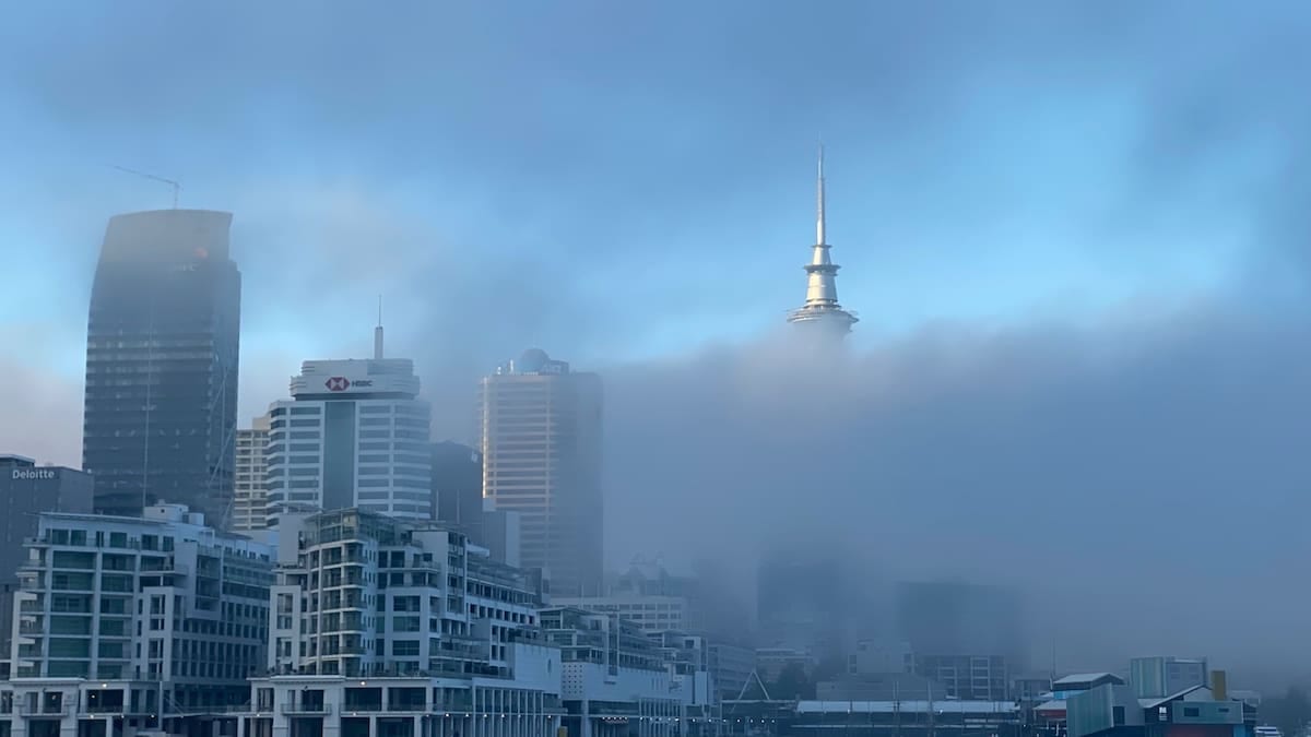
Morning fog throws Auckland travel plans into disarray
Low cloud and dense fog around Auckland Airport led to a series of delays and cancellations on Saturday morning, affecting regional services in particular. Publicly available flight data and local coverage indicate that dozens of domestic sectors were either scrubbed or held on the ground as visibility briefly dropped to near zero on parts of the airfield.
Airport operations information and independent weather observations show that the reduced visibility was most severe through the early and mid-morning period, with conditions improving toward midday as the fog slowly lifted into low cloud. Larger jet services were able to operate under low-visibility procedures, but smaller turboprop aircraft faced tighter operating limits, resulting in a patchwork of cancellations across the regional network.
Weather monitoring sites near Auckland Airport reported light winds, saturated air and surface temperatures in the single digits Celsius, a classic setup for radiation fog that forms overnight and lingers after sunrise. Aviation records for the morning showed visibility at times measured in hundreds of metres, well below typical thresholds for routine arrivals and departures.
According to published reports, the disruption followed a similar pattern to previous winter fog events in the city, where early morning schedules are most exposed. Travellers reported being rebooked later in the day or routed through alternative airports as airlines worked to restore normal timetables once the fog began to thin.
Passengers urged to expect ongoing knock-on delays
Although the immediate fog restrictions around Auckland eased by late morning, the backlog created a ripple effect across the domestic network. Airline schedules showed aircraft and crews out of position, leading to altered departure times through the afternoon and early evening, even as skies cleared.
Publicly available travel advisories urged passengers to check their flight status frequently and to allow additional time for connections, particularly those linking regional centres with Auckland-bound services. Some long-haul flights arriving from overseas also experienced extended taxi or holding times while ground movements were sequenced more cautiously in the low visibility.
Industry analysts note that fog-related disruptions can be harder to unwind than delays linked to rain or wind, as restrictions tend to coincide with the morning “bank” of departures and arrivals that underpin the rest of the day’s schedule. Once those early services are affected, recovery often requires aircraft swaps, consolidations and later departures, especially on high-frequency domestic routes.
Travel forums and social media posts on Saturday reflected a mix of frustration and acceptance among passengers, with many acknowledging that safety-driven visibility limits leave little room for flexibility. Some travellers highlighted accommodation and transport vouchers offered in line with airline policies, while others reported choosing to postpone non-essential trips by a day.
South Island braces for heavy rain and gale-force winds
While Auckland contends with lingering low cloud and patchy fog, attention is turning to the South Island, where forecasters are tracking an approaching system expected to bring a period of intense wet and windy weather. Publicly available guidance from New Zealand weather services points to a front and deepening low moving in from the Tasman Sea, targeting southern and western regions first.
Forecast charts indicate that Fiordland, Westland and parts of Southland and Otago are likely to see the heaviest rain, with accumulations building overnight and into the first part of the new week. On exposed coasts and higher terrain, gale-force north to northwest winds are expected, raising the risk of hazardous driving conditions, fallen branches and localised power interruptions.
The incoming system follows a week in which parts of the country have already experienced active weather, including strong swells and gusty winds in central regions. Climate summaries and recent reporting highlight a pattern of frequent low-pressure systems crossing New Zealand in early winter, bringing a succession of fronts that test infrastructure and transport networks.
Road controlling authorities and emergency planners routinely flag South Island events of this type as a concern for alpine passes, remote highways and areas prone to rising rivers. Travellers planning to drive between major centres such as Queenstown, Dunedin, Invercargill and the West Coast are being urged through public advisories to monitor forecasts, carry warm clothing and be prepared for sudden changes in conditions.
Potential impacts on regional air links and tourism
The combination of foggy conditions in the north and severe weather prospects in the south underscores the vulnerability of New Zealand’s air links to rapid shifts in winter patterns. Regional airports serving gateways such as Queenstown, Dunedin and Invercargill can be particularly exposed when low cloud, strong winds or heavy rain coincide with peak travel periods.
According to aviation schedule data and recent climate assessments, winter is one of the most challenging seasons for maintaining on-time performance across the domestic network, with fog, icy runways and stormy systems all playing a part. When multiple weather hazards occur across different parts of the country, airlines can face complex decisions about where to position aircraft and which routes to prioritise.
The current sequence of weather events arrives as the tourism sector continues to promote winter attractions, from ski fields in the Southern Alps to city breaks in Auckland and Wellington. Travel industry commentators note that while adverse weather can disrupt itineraries, it also highlights the importance of flexible bookings, comprehensive travel insurance and clear communication between operators and visitors.
Local tourism organisations are expected to keep a close watch on both the South Island rain and wind outlook and any renewed fog risk in Auckland, particularly during weekends and school holiday periods when visitor numbers spike. Many operators now build contingency plans into their guest communications, advising on alternative activities or amended check-in times when significant weather is on the horizon.
What travellers should watch over the coming days
With fog in the upper North Island and a strengthening system approaching the South Island, travel planners are recommending a cautious approach for the remainder of the weekend and into early next week. Publicly available airport updates suggest that Auckland’s immediate fog disruption is easing, but early-morning flights on clear, calm nights will remain vulnerable to renewed low cloud and mist.
In the south, attention is focused on the timing and intensity of the heaviest rainfall and strongest gusts. Forecast discussions point to the possibility of rapidly changing conditions along key corridors, including routes linking inland towns to the coast. Short-notice road warnings, reduced speed limits and occasional closures are possible if rainfall totals or wind speeds exceed expectations.
Travel experts commonly advise building extra time into itineraries during New Zealand’s winter, especially for those relying on same-day connections between regional flights and international departures. Simple precautions such as registering for airline alerts, checking forecast maps before setting out, and keeping an eye on local news coverage can help reduce the stress associated with sudden schedule changes.
As the season progresses, meteorologists and climate researchers will continue to study how recurring patterns of fog, heavy rain and strong winds intersect with New Zealand’s busy travel calendar. For now, those heading through Auckland or south toward the country’s more remote landscapes are being encouraged, through publicly available advisories, to stay informed and remain flexible as the latest round of winter weather unfolds.