
Ask a New Jersey driver which road is faster, the Garden State Parkway or the New Jersey Turnpike, and you will usually get a passionate answer rather than a simple one. Both highways run roughly north–south, both are toll roads, and both can move you quickly when conditions are good. Yet each has its own geometry, traffic patterns, toll setup and choke points that affect how long a given trip will take. For travelers planning routes between North Jersey, the Jersey Shore, Philadelphia, Delaware or New York City, understanding the tradeoffs can easily mean saving 15 to 30 minutes on a busy weekend drive.
Get the latest updates straight to your inbox!
How the Two Roads Are Designed and Where They Run
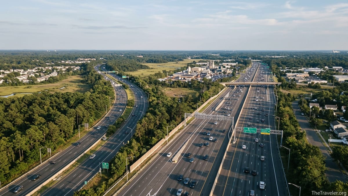
The New Jersey Turnpike is the state’s heavy-duty interstate corridor. It runs from the Delaware Memorial Bridge in the southwest to the vicinity of the George Washington Bridge in the northeast, tying directly into I‑95 and major freight routes. Built for high volumes and long-distance travel, much of it uses a wide dual-dual configuration, with separate inner car lanes and outer truck lanes. Speed limits are generally 65 mph in the south, dropping to about 55 mph in the more urban northern sections, although posted limits vary by segment.
The Garden State Parkway is a different experience. It runs 172 miles from Cape May at New Jersey’s southern tip to Montvale on the New York state line, hugging the eastern side of the state and feeding almost every major Jersey Shore community along the way. The Parkway is posted mostly at 65 mph, with lower limits in denser stretches between about Paramus and Old Bridge and near Toms River. Commercial traffic is banned on sections north of Exit 105, keeping heavy trucks off the roadway in that part of North Jersey.
This difference in design matters for time. The Turnpike is more of a long-haul express spine between states and major cities. The Parkway doubles as both an intercity highway and a local access road to shore towns and suburbs, with more on- and off-ramps that create turbulence in traffic flow. On a clear weekday outside rush hour, the Turnpike’s straighter geometry and separated truck lanes often make it the more consistently fast choice for through travel.
However, because both roads parallel each other over long stretches, especially between about Exit 7A on the Turnpike and Exit 98 on the Parkway, the faster option for any given trip depends heavily on where you start, where you are going and when you drive.
Typical Speed, Congestion and When Each Road Bogs Down
Average speeds on both roads are highly time-of-day dependent. In southern and central New Jersey, outside the major commuting peaks and summer weekends, many drivers report cruising near the speed limit or slightly above on both highways. During weekday rush hours around North Jersey, especially near Newark, Elizabeth, Woodbridge and the approaches to New York City, speeds on either road can plunge well below 30 mph during incidents or heavy volume.
The Turnpike’s worst congestion tends to center around the Newark Airport Interchange and the dual spurs leading toward the Lincoln Tunnel and George Washington Bridge. This is the heavily industrial zone many locals refer to as one of the most stressful two-mile stretches in the region. Morning and evening peaks here can add 20 minutes or more to what would otherwise be a short segment between Interchange 11 (Woodbridge) and Interchanges 14 through 18E/W. On Friday evenings and Sunday afternoons, long-distance traffic heading to and from New England, New York and the Mid-Atlantic stacks on top of commuter flows.
The Parkway’s defining bottlenecks are different. North of Exit 130, between about Woodbridge Township and Union County, the combination of narrow older geometry, frequent merges and exits toward Route 22, I‑78 and local arterials can turn the road into a slow crawl at peak hours. South of Exit 98, however, the Parkway often feels more open, with tree-lined medians and relatively free-flowing traffic outside summer rushes.
Shore season is where the Parkway’s time penalty can really appear. On a sunny July Saturday morning, northbound traffic toward New York may be smooth, while southbound lanes toward the beaches back up for miles around exits 80 to 98. On Sunday evenings, that pattern reverses, and it is common for a trip from, say, Point Pleasant (Exit 98) to the Parkway’s northern end to take 30 to 60 minutes longer than the same distance on a quiet winter Sunday.
Real-World Trip Example: Philadelphia to New York Area
Consider a traveler starting near downtown Philadelphia and heading to Midtown Manhattan on a regular weekday. A common fastest route is I‑95 across the Delaware River into New Jersey, then north on the New Jersey Turnpike toward the Lincoln Tunnel or George Washington Bridge. For most drivers, using the Turnpike straight through will save significant time compared with trying to cut east to the Parkway early and then following that road all the way north.
In light traffic, the distance from the Delaware Memorial Bridge area to the George Washington Bridge via the Turnpike is roughly 120 to 130 miles, much of it at posted 65 mph. Barring incidents, a driver might cover this in approximately two to two and a half hours. By contrast, routing to the Garden State Parkway earlier would require jogs across east–west connectors such as Route 195 or Route 138. Those connectors introduce traffic signals, local congestion and weaving that can easily add 15 to 25 minutes even when there are no crashes or lane closures.
However, timing flips some of these assumptions. If a crash closes lanes on the Turnpike north of Newark during the evening rush, local drivers often divert via the Parkway despite its lower design standards, because the parallel capacity gives them options. In a severe incident scenario, detouring via the Parkway and perhaps even surface routes like Route 9 can turn into the lesser of two evils, saving half an hour over sitting in a stationary Turnpike queue.
Cost can also tilt the choice. The Turnpike uses distance-based tolling. A full-length northbound drive from near the Delaware River to the New York metro area in a passenger car can run to a noticeable toll charge, especially during peak periods with higher E‑ZPass rates. The Parkway tends to have lower per-trip tolls but more plazas, which affects total cost and stopping patterns. A traveler deciding between the two should consider whether a potential 15-minute time saving on the Turnpike is worth a somewhat higher toll bill for that particular journey.
Real-World Trip Example: North Jersey to the Jersey Shore
For many travelers, the most practical comparison is getting from North Jersey suburbs to the Shore. Imagine leaving Montclair or Jersey City for a weekend in Ocean City. The most common fast route is to use the New Jersey Turnpike south to about Exit 4 or 3, connect to the Atlantic City Expressway, then cut over to the Parkway near Atlantic City before continuing south toward Exit 25 for Ocean City. This route leverages three expressways specifically designed for higher-speed through travel.
Alternatively, drivers could aim directly for the Garden State Parkway and then follow it the entire way south. From northern Essex or Hudson County, that usually means working across dense local roads or short segments of I‑280 and I‑78 to join the Parkway near Union, then staying on it past Asbury Park, Toms River and the Barnegat area before reaching Cape May County. In non-summer months and outside peak commuting windows, this can feel like a scenic, reasonably quick drive, with long forested stretches and regular service areas.
On a classic July Friday afternoon, though, the story is different. Traffic around Union County on the Parkway can be congested simply from local commuting, then intensify around Exits 98 to 63 as waves of weekenders join from Route 138, I‑195 and surface roads. Queues at toll plazas, particularly where cash lanes coexist with E‑ZPass gantries, can contribute to slowdowns despite speed limits of 65 mph in many sections. In these conditions, the Turnpike plus Expressway combination often wins on time, even though the total distance may be slightly longer.
To make this comparison more concrete, think of a late Friday departure from Jersey City at 4:30 p.m. Online mapping services on summer Fridays often show estimated travel times to Ocean City of three and a half to over four hours via the Parkway, versus roughly three to three and a half hours using the Turnpike and Atlantic City Expressway. The difference comes from where the bulk of the congestion sits: on the Parkway’s approach to the Shore, not on the southern Turnpike or Expressway, which typically remain smoother until holiday peaks.
Tolls, Service Areas and Driving Comfort
While your main concern may be time, the toll structure and overall driving comfort subtly affect how quickly you can safely cover ground. The Turnpike’s distance-based tolling means you pass fewer plazas, but each entry and exit is metered from origin to destination. If you drive a long north–south segment, your total toll cost climbs steadily. Drivers with New Jersey E‑ZPass accounts typically pay slightly lower off-peak rates than out-of-state tags or cash passengers, but amounts change periodically, so it is worth checking current toll schedules before a long trip.
The Parkway, on the other hand, uses a series of fixed-price barriers and ramp tolls. Each one is a smaller amount, but there are more of them than on the Turnpike. During heavy traffic, older-style plazas where lanes split between cash and E‑ZPass can briefly act as mini bottlenecks. You may keep moving, but the constant changes in speed at each plaza and ramp can sap momentum and increase perceived travel time, especially north of the major shore exits.
Service areas also influence comfort and, indirectly, time. Both roads have regular rest and fuel stops with recognizable chains such as Starbucks, Dunkin and major fast-food brands. The Turnpike’s large service plazas are generally spaced to suit long-distance interstate drivers; pulling off, refueling, using restrooms and getting back on tends to involve fewer ramps than exits on the Parkway leading into local commercial strips. On the Parkway you will find a mixture of true median service plazas and exits into nearby towns for gas and food. In heavy summer traffic, re-entering the Parkway from a local exit can mean more merging and potential delays.
Truck traffic also affects how relaxed and fast a drive feels. The Turnpike carries substantial freight volume, but its divided inner car lanes in the central and northern sections separate many of those trucks from passenger vehicles when conditions allow. On Parkway segments where trucks are banned, particularly north of Exit 105, the flow is biased more toward cars and light vehicles, which some drivers perceive as smoother at moderate speeds, though it can also encourage more aggressive lane changes.
When the Parkway Saves Time vs When the Turnpike Wins
In practical terms, the Parkway tends to save time when your origin or destination lies close to the eastern side of the state or along the shore, the time of day is outside peak commuting or beach rush hours, and the segment you are driving avoids the chronic bottlenecks around Union County. For example, traveling from Red Bank or Long Branch to Newark Liberty International Airport at 10 a.m. on a Tuesday will typically be fastest via the Parkway north to the Turnpike connector, avoiding unnecessary backtracking.
Similarly, if you are moving between shore towns, such as from Cape May Court House to Asbury Park, staying on the Parkway is usually much quicker than exiting inland to reach the Turnpike. The Parkway effectively functions as the spine of the Jersey Shore. Even with occasional slowdowns, its limited-access design beats stop-and-go traffic on parallel surface routes like U.S. 9.
The Turnpike generally saves time when your trip is largely between interstates or major inland cities, such as Philadelphia to New York, Trenton to Newark, or Delaware to the New York suburbs. It is also often the better bet during peak summer beach travel if your route would otherwise require navigating the busiest Parkway shore segments, such as Exits 80 to 98, at exactly the times thousands of other vacationers are doing the same.
An example: a family driving from Princeton to Wildwood on a summer Saturday. They can take Route 295 or the Turnpike south, then the Atlantic City Expressway and finally the Parkway southbound. If they instead try to cut directly across to the Parkway near, say, Toms River to drive south from there, they will face dense north–south beach traffic earlier and for longer. The Expressway route concentrates more of the trip on higher-speed, less Shore-focused corridors, which, in practice, typically trims 20 to 30 minutes from the journey on busy days.
Planning Strategies to Actually Save Time
Whichever road you choose, timing and flexibility often matter more than the theoretical maximum speed limit. In New Jersey, serious drivers treat live traffic apps as essential tools. Before committing to either the Parkway or Turnpike for a long north–south run, it is wise to check both the New Jersey Turnpike Authority’s official traffic maps and popular navigation apps for incidents and average speeds segment by segment.
On a typical weekday, one practical strategy involves pairing the two roads instead of treating them as rivals. For example, driving from central Monmouth County to northern Bergen County, you might use the Parkway for the southern half of the trip, then transition to the Turnpike or other interstates near the Newark Airport or the Meadowlands, depending on which corridor shows fewer delays at that moment. This mixed approach can claw back 10 to 20 minutes compared with stubbornly sticking to one highway out of habit.
Departure time is equally crucial. Leaving North Jersey for the Shore at 6 a.m. on a Saturday often means an easy 90-minute run from the metro area to Ocean County via the Parkway. Leaving at 10 a.m. the same day may double that travel time on sunny summer weekends. Similarly, attempting to use the Turnpike through the Newark area at 5 p.m. on a weekday invites predictable congestion, while a departure at 7 p.m. can transform that same route into a quick, low-stress drive.
Finally, local knowledge still counts. Regular commuters often know that in certain micro-corridors, a well-timed alternate like Route 18, Route 9 or I‑195 can shave time off a segment where both the Parkway and Turnpike are struggling. For visitors, using real-time navigation with traffic awareness is the closest substitute, but it is worth remembering that algorithms sometimes optimize for distance or toll cost rather than driver comfort. Reviewing the route for long segments on either roadway before departure can help you decide whether saving a few dollars in tolls is really worth adding 15 minutes and more stress to the trip.
The Takeaway
There is no single, always-correct answer to whether the Garden State Parkway or the New Jersey Turnpike will save you more time. The Turnpike is generally faster for long-distance, interstate-style trips, particularly between Philadelphia, Delaware or central New Jersey and the New York region, thanks to its straighter alignment, higher speeds in the south and distance-based toll system that reduces the number of plazas. The Parkway typically shines when your trip begins or ends near the coast or within the eastern suburbs and when you can avoid peak beach and commuter surges.
For travelers, the most reliable way to turn this understanding into real time savings is to think in terms of corridors and time windows rather than fixed loyalties. Ask where you are coming from, where you are going and what the traffic usually does at the time you plan to drive. Use current traffic data to check both roads, stay flexible about switching between them where interchanges allow, and consider whether paying a little more in tolls to stay on the Turnpike, or enduring more plazas to enjoy the Parkway’s coastal access, is worth the time and stress tradeoff for that specific journey.
With that mindset, you can make either road work in your favor. Sometimes the fastest north–south crossing of New Jersey will be a clear, truck-lane spin down the Turnpike. Other days it will be a surprisingly serene Parkway cruise through pine forests and marshes. The key is knowing how each road behaves and tailoring your choice to the realities of traffic, season and your own travel priorities.
FAQ
Q1. Is the Garden State Parkway or the New Jersey Turnpike usually faster for driving through the entire state?
The New Jersey Turnpike is usually faster for long, end-to-end trips through New Jersey, especially between Delaware or Philadelphia and the New York City region, because it is straighter, built to higher interstate standards in many sections and has fewer local access points that can slow traffic.
Q2. When does the Garden State Parkway save more time than the Turnpike?
The Parkway saves time when your origin or destination is near the Jersey Shore or eastern suburbs, you are traveling outside peak commuter and beach hours, and you can avoid known bottlenecks around Union County and the busiest shore exits.
Q3. How much time can I realistically save by choosing the Turnpike over the Parkway on a north–south trip?
On a typical non-summer weekday with no major incidents, choosing the Turnpike over the Parkway for a long north–south run can save around 15 to 30 minutes, though the exact figure depends on starting and ending points and current traffic.
Q4. Do tolls affect which road is faster in practice?
Tolls do not directly change speed limits, but toll layouts and driver behavior around plazas can influence how smoothly traffic flows. The Turnpike tends to have fewer, larger toll points, while the Parkway has more, smaller plazas that can contribute to minor slowdowns, particularly in mixed cash and E‑ZPass zones.
Q5. Which road is better in summer for trips to the Jersey Shore?
In summer, the Parkway is the main shore route and can be heavily congested near popular beach exits on weekends. Often, combining the Turnpike with the Atlantic City Expressway and then using the Parkway only for the final stretch can be faster than staying on the Parkway for the entire distance.
Q6. Are trucks allowed on both the Parkway and the Turnpike?
Heavy trucks are allowed throughout the Turnpike and use dedicated truck lanes in many sections. On the Parkway, commercial vehicles are restricted or banned in certain northern segments, which changes traffic mix and can slightly affect travel speeds and driving comfort.
Q7. How do rush hours change which road is faster?
During weekday rush hours, the Turnpike is often slower near Newark, Elizabeth and the approaches to New York City, while the Parkway tends to bog down between Woodbridge and Union. Depending on your route, picking the corridor with fewer rush-hour choke points can save 20 minutes or more.
Q8. Is the Parkway more scenic, and does that mean it is slower?
The Parkway is generally more scenic, with tree-lined medians and closer proximity to the coast, and that sometimes coincides with slower travel because it functions as both a through route and local access highway. However, in off-peak periods, it can feel just as fast as the Turnpike on many segments.
Q9. Should I always follow my navigation app’s suggestion for the faster route?
Navigation apps are useful, but they may optimize for distance or toll cost rather than your preference for fewer merges, smoother driving or predictable service areas. It is wise to review the suggested route, note how much time is actually saved and decide whether the tradeoffs fit your priorities.
Q10. What is the best overall strategy for choosing between the Garden State Parkway and the New Jersey Turnpike?
The best strategy is to check live traffic on both roads before departure, consider your exact origin and destination, account for rush hours and shore traffic patterns, and remain flexible about switching corridors at key interchanges if conditions change while you are en route.