
The first time I realized how easy it is to disappear in the New Jersey Pine Barrens, my phone map showed only a blank green smear and a single gray line that had long since crumbled into sand. The hum of the Garden State Parkway felt a world away. Around me, stunted pitch pines crowded close, the sky had folded into a narrow ribbon of blue, and a silence as thick as fog settled over the forest. It was creepy, disorienting, and yet, in a way I did not expect, weirdly beautiful.
Get the latest updates straight to your inbox!
A Wilderness Hiding in America’s Densest State
On a map, the Pine Barrens are a pale green patch stretching across more than a million acres of southern New Jersey, from just inland of Barnegat Bay to the edge of the Delaware River. On the ground, they feel more like another country entirely. Within minutes of leaving a paved road at Atsion, Batsto, or Bass River State Forest, the state’s heavy traffic and strip malls dissolve into an expanse of pitch pine and scrub oak that seems to go on forever. The Pine Barrens are technically the New Jersey Pinelands National Reserve, a protected mosaic of state forests, old cranberry bogs, rivers, and sandy backroads that forms one of the largest wild landscapes between Boston and Richmond.
The name “barrens” comes from the sandy, acidic soil that frustrated farmers centuries ago, but that same soil helped preserve this landscape from the intense development that transformed so much of the rest of the state. Today, you can stand on Apple Pie Hill, a low rise in Wharton State Forest, and gaze from the Atlantic City skyline in one direction to the distant smudge of Philadelphia in the other, with nothing but forest in between. For many travelers who know New Jersey only from the Turnpike, that view alone is unsettling. It is a reminder that wildness can hide in plain sight, even in one of America’s smallest and most densely populated states.
Yet the Pine Barrens are not a park in the conventional, tightly managed sense. They are a working, living ecosystem of fire-adapted pines, cedar swamps, and slow tannin-stained rivers. Sand tracks far outnumber paved roads. Directional signs are sparse, and many junctions look nearly identical. This is a place where a wrong turn can very quickly turn into an unplanned night out, especially for travelers who arrive with only a car GPS and no real sense of how big the forest really is.
How Getting Lost Actually Happens Here
Most people do not set out to get lost in the Pine Barrens. It usually starts with a seemingly innocent decision: turning off the asphalt at Atsion into Wharton State Forest to “explore a bit,” or leaving the well-marked red or blue loop near Batsto Village to follow an unblazed sand track that looks more interesting. The roads here can be deeply rutted sugar sand that swallow tires and blur into one another. On a summer afternoon, when the sun is high and the forest looks uniform in every direction, even experienced hikers and drivers can lose their bearings.
I felt that slide into uncertainty on a late-autumn walk that started at the Atsion Recreation Area. The official Mullica River Trail was obvious at first, marked with yellow blazes through airy pine forest. Then an old fire road branched off, just wide enough to seem legitimate, just worn enough to feel like it went somewhere. Within fifteen minutes the blazes had disappeared, the path had braided into several faint tracks, and the only constant was the crunch of sand underfoot. Pulling out my phone, I watched as the dot drifted off the clearly drawn line of the trail and onto an unmarked nothing. Signal bars dropped to one.
Stories among locals and hikers echo the same pattern. A couple sets out to find the Apple Pie Hill fire tower by following a sandy track from the Carranza Memorial rather than one of the blazed sections of the Batona Trail. A family in a crossover turns deeper into Wharton’s interior at each fork, assuming a loop that does not exist will eventually bring them back toward Route 206. Paddlers on the Mullica or Wading rivers, lulled by the narrow channel and repetitive curves, overshoot their intended take-out because every bend looks the same. Navigation errors here are not dramatic; they are a slow accumulation of tiny, reasonable choices that end with the realization that you are no longer quite sure where you are.
The good news is that, for most travelers, “lost” in the Pine Barrens means disoriented rather than in true danger. Roads, rivers, or power lines are rarely more than a few miles away. Still, that first moment of doubt, when you realize your mental map is wrong and the forest feels suddenly bigger and more watchful, can be deeply unnerving.
The Atmosphere: Eerie Silence, Dark Water, Endless Pines
The creepiness of the Pine Barrens is not the jump-scare kind found in horror movies. It is slower, quieter, and more insidious. By day, the forest seems unremarkable at first glance. Pitch pines as tall as telephone poles stand in ragged rows; scrub oaks twist into strange shapes along the edges of old sand roads. But walk just a few minutes off the popular loops near Batsto Village or Bass River State Forest and the human world recedes quickly. Car noise fades. Cell service flickers. The only sounds might be the rasp of the wind in the needles and the occasional croak of a raven or the bell-like call of a pine barrens treefrog from some hidden pond.
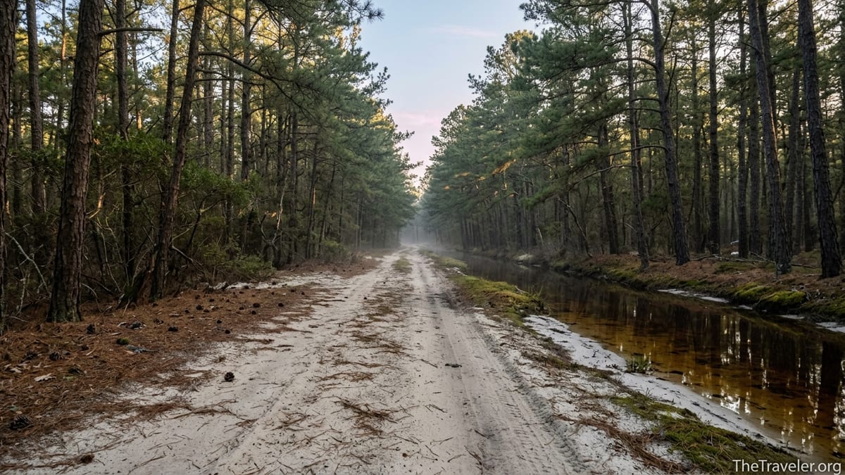
Then there is the water. The rivers and streams that wind through Wharton State Forest, like the Mullica, Batsto, and Wading, are the color of strong tea. The tannins that leak from cedar roots and decaying leaves stain them a deep reddish brown. From a canoe, peering into the Mullica’s glassy surface below Atsion Lake, you may see only a few inches before darkness swallows everything. On cloudy days, the river can look almost black, while white sandbars gleam at the edges. It is beautiful in photographs and disconcerting in person, especially when submerged branches and logs appear suddenly just beneath your paddle.
At twilight, the Barrens take on an even stranger character. The forest floor is a patchwork of charcoal, pine needles, and pale lichen. Burn scars from old wildfires give some stands of trees a skeletal, ghostly look. Fog often rises from the low, wet cedar swamps on cool evenings, pooling along the roads and hugging the riverbanks. Standing on a quiet stretch of the Batona Trail in that dim light, the trees crowding close, the sense that you are very much alone becomes impossible to ignore. It is easy to see how, long before horror podcasts and found-footage films, people sitting around Pinelands campfires began telling stories about strange things in the woods.
Folklore in the Trees: The Jersey Devil and Other Ghosts
No tale from the Pine Barrens looms larger than that of the Jersey Devil, the supposed winged creature that has haunted South Jersey folklore since at least the 18th century. According to one common version of the story, a woman named Mother Leeds, already burdened with twelve children, cursed her thirteenth, which then transformed into a hooved, bat-winged monster and fled into the Barrens. Over the centuries, the Devil has been blamed for livestock mutilations, eerie screams in the night, and unexplained tracks in the snow. An entire National Hockey League team, the New Jersey Devils, owes its name to this creature.
In reality, of course, there are more mundane explanations for many of the reported sightings: sandhill cranes startled in flight, misidentified owls, and the active imaginations of people already primed with campfire stories. But when you are standing at a remote crossroads near Chatsworth, long after the last car has passed, the idea of something unseen moving just out of view among the pines does not feel entirely out of place. The Barrens are fertile ground for mythmaking. They are dark, difficult to navigate, and filled with strange natural features like “blue holes,” deep, startlingly clear pools in the woods whose origins are still debated.
The Jersey Devil is only the beginning. Local stories tell of the ghost of Captain Kidd hiding treasure along the Mullica River, a spectral white stag that appears on lonely roads to warn travelers of danger, and the “Black Doctor,” the spirit of an African American physician said to help injured wanderers deep in the forest. Whether or not you believe in such things, it is hard to deny that the setting suits them. Old ironworks villages like Batsto, once noisy centers of bog iron smelting, now stand as preserved historic sites, their weathered buildings and rusting artifacts surrounded by quiet forest. Smaller settlements simply vanished, leaving behind collapsed cellars, stray gravestones, and crumbling brick chimneys half-swallowed by moss and blueberry bushes. Hiking the Batona Trail or paddling the Batsto River, you may pass within a few yards of these relics without ever seeing them.
This overlay of folklore on real, abandoned places is part of what makes getting lost here feel different from losing your way in a more conventional state park. The sense that you are slipping sideways in time as well as space, into a version of New Jersey where ghost towns outnumber active villages, can be both unsettling and irresistible.
Finding Beauty in the Disorientation
Yet for all its eerie qualities, the Pine Barrens are also profoundly beautiful, especially when you surrender to their scale and rhythm. The first time I realized this was while following a wrong turn on a sandy track south of Apple Pie Hill. The road pinched down to little more than a single lane of ruts and loose sugar sand. Turning around meant a long, awkward three-point maneuver with a real chance of getting stuck. So I kept going, creeping along at walking speed, tires hissing in the sand, until the forest opened into a small clearing filled with low shrubs and shimmering grasses.
It looked unremarkable at first. Then I noticed the tiny sparks of color near my boots: wild blueberries, each no bigger than a pea, clinging to the low bushes that thrive in the Barrens’ acidic soil. Pitcher plants, bizarre carnivorous flowers, hid in the damp edges, their red-and-green fluted tubes waiting for unlucky insects. Overhead, the afternoon light caught in the fine needles of the pines, turning them almost silver. There were no trail signs, no boardwalks, no overlook platforms. The beauty here was subtle and absolutely inseparable from the sprawling, lightly managed nature of the landscape that had confused me moments before.
Travelers who approach the Pine Barrens with curiosity rather than conquest often report similar moments. Backpackers on the Batona Trail, a roughly 53-mile route that winds from Ong’s Hat down through Wharton State Forest to Bass River, describe sunrises over deserted cranberry bogs, when the water turns to molten gold and thin strips of mist hover just above the surface. Paddlers on the Wading River remember gliding through cathedral-straight rows of pines reflected perfectly in the tea-colored water, the only sound the drip of their paddles and the distant call of an osprey. Even something as ordinary as driving a Forest Fire Service road at dusk, windows down, the scent of pitch resin and damp sand flooding the car, can be hypnotic.
Getting a little lost in a landscape like this forces you to slow down and pay attention in ways that a quick roadside stop never does. The need to orient yourself makes you notice small details: the direction of the river’s current, the angle of the sun through the pines, the difference between a frequently used sand road and a faint, grass-choked track leading to an old bog. What feels creepy at first, that sense of being swallowed by the forest, can soften into a more complicated feeling: awe.
Practical Realities: Safety, Navigation, and Respect
Romanticizing the experience of getting lost in the Pine Barrens has its limits. This is still a place where people need to take practical precautions. Summer heat can turn the sandy roads and open bog edges into baking ovens. Mosquitoes and ticks are relentless. Wildfire risk is real in a landscape where pitch pines have adapted to burn. Off-road driving on unapproved routes can damage sensitive habitats and, in recent years, has prompted crackdowns and closures by New Jersey authorities.
If you decide to explore beyond the most popular picnic areas at Atsion Lake or the historic buildings of Batsto Village, a few simple steps make a big difference. Carry a paper map of Wharton State Forest or the wider Pinelands, which are available at major park offices and visitor centers. Download offline maps for your phone before you lose reception. Stick to marked hiking trails like the Mullica River Trail, the Batona Trail, or shorter color-blazed loops around Batsto and Bass River, at least until you have a feel for how the forest is laid out. Tell someone which access point you are starting from and when you expect to be back; this is especially important if you are parking at more remote trailheads along roads like Carranza or Quaker Bridge.
For paddlers, local outfitters running trips on the Mullica, Batsto, and Wading rivers typically provide a basic safety briefing along with rental canoes or kayaks. Listen closely. On these narrow, winding streams, downed trees, branches just below the surface, and tight turns are as much a hazard as the tannin-dark water. Even if your phone is in a dry bag, do not count on having signal to call for directions. Watch the river’s current and daylight instead. If you reach an unfamiliar bridge or landing that does not match the description given by the outfitter, take a moment to get out, look around, and reorient rather than drifting past in hope that the next bend will look more familiar.
Finally, respect the landscape and the people who live around it. The Pine Barrens are not an abandoned playground. Year-round residents, from small communities near Chatsworth and Shamong to people with isolated homes reached only by long sand roads, share these woods with visitors. Avoid driving on roads that are clearly posted as closed, and do not attempt to reach features like Apple Pie Hill Fire Tower if state officials have temporarily restricted access. The creepiness of the forest comes from its wildness and history, not from disrespectful behavior or thrill-seeking at the expense of the environment and local communities.
Turning a Misstep into a Memorable Journey
Looking back, the hour or so I spent genuinely unsure of my location outside Atsion changed how I travel in big, subtle ways. Instead of treating the Pine Barrens as an oddity sandwiched between more obviously dramatic destinations, I began to see them as a place that demanded the same respect and attentiveness as any national park out West. Getting lost, within reason, became part of the point. On subsequent visits, I deliberately left small margins of uncertainty in my plans: a side trip on foot down an unmarked spur that still ran parallel to the Batona Trail, a sunset paddle on the Mullica that ended just before dark instead of safely in midafternoon.
Other travelers tell similar stories. A group of friends heading for Apple Pie Hill, frustrated by confusing directions from their navigation app and conflicting sand tracks on the ground, eventually abandoned the tower goal altogether. Instead, they followed a nearby section of the Batona Trail on foot and ended up at a quiet overlook where a narrow, unnamed stream cut between banks of white sand and cranberry-colored moss. The fire tower would have offered a sweeping view, but the accidental detour created a more intimate encounter with the forest’s finer textures. A pair of paddlers who missed their planned take-out on the Batsto River spent an extra two hours on the water, nervous at first, then slowly relaxing as they realized that the river, for all its repetitive bends, would eventually deliver them to a bridge or landing. By the time they reached the next access point, exhaustion had given way to a deep appreciation for how much distance those winding miles of black water could contain.
There is a line, of course, between productive disorientation and real trouble. Pushing into the Barrens at night without proper lights and gear, attempting to drive deep sand roads in a low-clearance sedan after a rainstorm, or entering the woods during an active wildfire warning are all ways to turn a promising adventure into an emergency. But with a reasonable margin of safety, the Pine Barrens reward those who are willing to let go of rigid itineraries and accept that this is not a place you can conquer in a day. It is a place you return to, learning its moods over time, getting less lost geographically even as you allow yourself to be more fully immersed.
The Takeaway
Getting lost in the Pine Barrens is rarely the dramatic, headline-making ordeal that horror stories and urban legends might suggest. More often, it is a quieter slip into uncertainty: a realization that the sand road you chose does not appear on any map, that the river bend you just rounded looks uncomfortably similar to the last ten, that the signal bars on your phone have vanished. In that moment, the forest’s folklore, ghost towns, and eerie silence exert a powerful pull on the imagination.
Yet it is precisely this combination of creepiness and beauty that makes the Pine Barrens one of the most compelling wild places in the northeastern United States. The same thin, sandy soils that defeated early farmers now support rare ecosystems and long, uninterrupted vistas of pine. The dark, tannin-stained rivers that can unsettle first-time paddlers are lifelines for countless plants and animals. The abandoned ironworks and forgotten cranberry bogs that feel like haunted movie sets are real, tangible reminders of past booms and busts.
If you come here prepared, with maps, common sense, and a flexible mindset, getting a little lost can become the highlight of your trip rather than its undoing. In the Pine Barrens, disorientation is not just a risk; it is an experience in its own right, a way of seeing how much wildness still survives in a state most people know only by its highways. Creepy, yes. But also, for those willing to wander a bit off the obvious paths, weirdly and unexpectedly beautiful.
FAQ
Q1: Is it actually easy to get lost in the Pine Barrens?
Yes. The forest is crisscrossed by similar-looking sand roads and unmarked paths, cell service can be unreliable, and official trail signage is limited in some areas, so it is surprisingly easy to become disoriented if you leave marked routes or rely only on phone navigation.
Q2: Are the Pine Barrens safe for solo travelers?
Generally yes, if you take basic precautions. Stick to established trails, start with popular access points like Atsion, Batsto Village, or Bass River State Forest, carry a map and water, and let someone know your plans. Avoid exploring unmarked sand roads alone, especially late in the day or in extreme heat.
Q3: What is the best way to navigate so I do not get seriously lost?
Use a combination of a printed map of Wharton State Forest or the wider Pinelands, a compass or GPS device, and offline maps on your phone. Follow blazed trails like the Batona or Mullica River Trail, pay attention at junctions, and turn back if paths become faint or confusing instead of pushing deeper into unfamiliar terrain.
Q4: When is the most atmospheric time to visit the Pine Barrens?
Many travelers love late afternoon into early evening in spring or fall, when cooler temperatures, long shadows, and occasional ground fog give the pines and cedar swamps a moody, almost otherworldly feel without the intense heat and insects of midsummer.
Q5: Is there any truth to the Jersey Devil legend?
The Jersey Devil is firmly in the realm of folklore rather than documented fact. The stories grew from early colonial tales and have been retold for generations. While locals enjoy the legend and some people claim strange encounters, most visitors experience only wildlife and the forest’s eerie quiet.
Q6: Can I safely paddle the Mullica or Batsto rivers as a beginner?
Yes, many outfitters run beginner-friendly trips on these rivers, providing boats, life jackets, and basic instructions. The current is generally gentle, but you should be comfortable in a small boat, listen closely to safety briefings, and be prepared for obstacles like downed branches, tight bends, and cold water outside summer.
Q7: Are there marked hikes that capture the Pine Barrens’ creepy beauty?
The Batona Trail, especially sections near Apple Pie Hill and through Wharton State Forest, offers long, quiet stretches of pine forest and bogs. Shorter loops near Batsto Village and Atsion Lake also pass through evocative stands of pines, old cranberry bogs, and dark cedar swamps without taking you too far from help.
Q8: What should I pack for a day exploring the Barrens?
Bring more water than you think you will need, a paper map and compass or GPS, sun protection, insect repellent, sturdy shoes suitable for sand, a basic first-aid kit, snacks, and a light layer for cooler evenings. A headlamp is wise if there is any chance you will be out near dusk.
Q9: Are there truly abandoned ghost towns I can see?
Yes, though “ghost town” can mean anything from a fully interpreted historic site like Batsto Village to scattered foundations and old cellar holes along remote roads. Many ruins are unmarked and fragile, so explore respectfully, stay off unstable structures, and avoid trespassing on private land near the forest’s edges.
Q10: How can I experience the Pine Barrens without risking getting lost?
Start with clearly signposted areas: walk the short color-blazed loops at Batsto Village, swim or picnic at Atsion Lake, or join a guided paddle trip with a local outfitter. These options provide a strong introduction to the landscape’s unique mix of eerie quiet and subtle beauty while keeping you well within the safety net of established facilities and easy navigation.