
Drive just an hour from the casinos of Atlantic City or the glass towers of Philadelphia and the landscape falls away into something far older, wilder, and stranger. New Jersey’s Pine Barrens, a 1.1‑million‑acre patchwork of pitch pine forest, cedar swamps, abandoned villages, and iron‑rich rivers, have long been a place where fact blurs into folklore. This sandy, seemingly empty wilderness has inspired generations of stories about demons, pirates, ghosts, disappearances, and bottomless lakes, yet it continues to draw hikers, paddlers, and road‑trippers curious to see what really hides between the twisted pines.
Get the latest updates straight to your inbox!
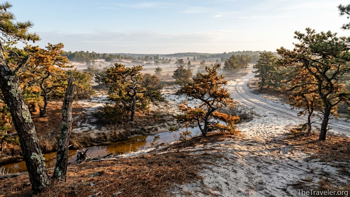
A Wilderness Hiding in Plain Sight
The Pine Barrens are one of the most surprising landscapes on the U.S. East Coast. Officially known as the New Jersey Pinelands, this protected region covers roughly a fifth of the state, stretching from the outskirts of Philadelphia almost to Cape May. It is a flat, sandy plateau where pitch pines and scrub oaks grow low and crooked, shaped by wind, fire, and poor, acidic soil. Beneath this seemingly barren surface lies the Kirkwood‑Cohansey aquifer, holding trillions of gallons of exceptionally pure groundwater that tint the region’s rivers and lakes a deep tea color.
For travelers used to shore traffic on the Garden State Parkway or dense suburbs along the New Jersey Turnpike, that sudden shift into emptiness can feel disorienting. Paved roads narrow to two‑lane blacktop, then to single‑track sand lanes with names like Quaker Bridge Road or Carranza Road. Cell phone service drops out in pockets of Wharton State Forest. At night, headlights can travel for long stretches without meeting another car. It is easy to understand why the first European settlers here spoke of being lost in a “wilderness of pines.”
Today, the region is crisscrossed by marked trails and byways, yet the feeling of isolation persists. You might park at the Atsion ranger station, just off Route 206, walk ten minutes into the woods, and suddenly realize that the hum of traffic has vanished, replaced by wind in the needles and the distant knock of a woodpecker. That contrast between one of America’s most densely populated states and a vast, quiet interior is the first reason the Pine Barrens naturally invite legends and unease.
From Lenape Homeland to Colonial Backwater
Long before the Pine Barrens acquired a spooky reputation, they were home to the Lenape people, who moved seasonally through the region, hunting, fishing, and burning the underbrush to maintain open woods and encourage game. They knew the cranberry bogs, the cedar swamps, and the shallow crossings on rivers like the Mullica and Wading, and they left behind artifacts and place names that still dot modern maps. For them, this was not a wasteland but a living, working landscape, and stories about spirits and powerful places helped explain its dangers and gifts.
When European colonists arrived, they found that the sandy, nutrient‑poor soils made conventional farming difficult. Coastal towns and river ports prospered, but the interior remained sparsely settled. Those who stayed became known as “pineys,” living in scattered hamlets and working in industries that relied on the forest itself: bog iron furnaces, charcoal making, glassworks, sawmills, and later, cranberry and blueberry farming. Places like Batsto Village, now a preserved historic site within Wharton State Forest, once rang with the clamor of an iron furnace that supplied goods during the American Revolution and the early republic.
Because the Pine Barrens sat off the main economic routes, they gained a reputation, often unfair, as a backwater full of reclusive people and strange customs. In the 19th and early 20th centuries, journalists from cities like Philadelphia and New York wrote sensational articles about the “pineys,” painting them as poor, inbred, and suspicious of outsiders. Those stereotypes later fed into modern myths, coloring how visitors interpreted every shadow and distant scream in the forest. Even today, when you walk past the weathered workers’ houses at Batsto or the ruins of the Harrisville paper mill along the Batona Trail, you can feel how economic isolation and prejudice helped set the stage for a region rich in rumor and fear.
The Jersey Devil and a Landscape Built for Monsters
No discussion of Pine Barrens lore can begin anywhere but with the Jersey Devil, the region’s most famous resident. According to popular versions of the legend, a woman named Mother Leeds in the 1700s gave birth to her thirteenth child in a storm‑lashed cabin near what is now Leeds Point or the Great Bay shore. Cursing the child, she watched in horror as it sprouted hooves, wings, and a forked tail, then flew up the chimney and into the pines. Over the centuries, locals and visitors have reported hearing its unearthly screech, finding strange hoofprints in the snow, or spotting a winged creature moving between the trees.
The story has countless variations, but what gives it staying power is how well it fits the landscape itself. Dense thickets limit your field of vision. On a winter night at a secluded campsite near Bodine Field or Godfrey Bridge, wind through bare pitch pines can produce high, keening noises that sound almost alive. Deer or foxes crashing through underbrush become sudden, unseen presences. A barred owl’s scream or the bark of a red fox is unsettlingly close to the noise some witnesses attribute to the Jersey Devil. Hike a section of the Batona Trail between Brendan T. Byrne State Forest and Bass River State Forest in fog, and it is not difficult to imagine something watching from just beyond the tree line.
The Jersey Devil has become more than a campfire story. It is New Jersey’s unofficial state demon, appears on hockey jerseys and souvenir T‑shirts, and draws paranormal investigators who set up night‑vision cameras near spots like the ruins of the Carranza Memorial area. Travelers sometimes plan entire weekend trips around “Jersey Devil tours,” driving sand roads by day to see reputed hotspots and then returning to rentals in Hammonton or Egg Harbor City to trade stories after dark. The creature is frightening, but it is also a powerful marketing symbol that keeps curiosity about the Pine Barrens alive.
Ghost Towns, Blue Holes, and Places That Refuse to Disappear
Folklore in the Pine Barrens is not limited to one monster. The region is scattered with sites that feel half‑abandoned and half‑remembered, each wrapped in its own myths. Take Ong’s Hat, for example. Once a tiny settlement near the intersection of present‑day Routes 70 and 72, it may have been little more than a tavern and a few houses. Over time it vanished from the landscape, but its unusual name survived on maps and road signs. In the late 20th century, writers and pranksters spun elaborate tales of secret laboratories at Ong’s Hat and experiments in interdimensional travel, a piece of early internet folklore that drew curious visitors down sandy side roads in search of foundations and fire rings.
Then there is the Blue Hole, a vivid, seemingly bottomless pool tucked deep in the woods off the Great Egg Harbor River. Locals debate its exact location, and travelers who find it are struck by its unnaturally clear blue water, so different from the surrounding tea‑colored lakes. Stories claim that the Blue Hole is the Jersey Devil’s favorite swimming spot, that the water is icy cold even in July, and that it drags down anyone who tries to dive too deep. In practice, erosion, submerged logs, and the lack of lifeguards make it genuinely dangerous, and state officials urge people not to swim there. The mix of real risk and exaggerated peril only strengthens its mythic status.
Ghost towns amplify this sense of a landscape that refuses to let the past go quietly. At Batsto Village, interpretive signs explain the ironworks, mansion, and workers’ cottages, and on busy fall weekends the parking lot fills with minivans and tour buses. Yet if you linger after closing time and walk toward the silent glassworks ruins, it is easy to imagine the clang of long‑cooled forges. Farther afield, foundations and stone walls from vanished communities like Friendship, Hampton Furnace, or Washington hide in the scrub, reachable by sand roads that sometimes require high‑clearance vehicles. Many hikers report a peculiar feeling in these places, a sense of time folding in on itself, as if the forest has swallowed whole chapters of human history but left their outlines intact to unsettle modern visitors.
Fire, Survival, and an Ecosystem Shaped by Extremes
The Pine Barrens are a fire‑adapted ecosystem, and that reality underpins much of the region’s drama. Pitch pines here have thick, fire‑resistant bark and can even resprout from trunks after burning. For thousands of years, both lightning and deliberate burning by Indigenous people kept the understory relatively open. In more recent centuries, wildfires sparked by human activity have periodically swept through with alarming speed, especially during dry, windy springs. Modern travelers driving along Route 563 after a large blaze may see expanses of blackened trunks and ash, creating a stark, almost lunar impression.
In recent years, large wildfires in places like Wharton State Forest have burned tens of thousands of acres, leading to highway closures, evacuations of nearby homes, and dramatic aerial images carried by local news outlets. On the ground, you might encounter smoke columns visible from canoe put‑ins at Hawkins Bridge or Evans Bridge on the Wading River, or pass freshly closed trails where the sand still holds a faint scent of char. Fire crews conduct prescribed burns in carefully chosen sections of forest each year, lighting controlled lines of flame to reduce accumulated fuel. Visitors driving past rows of yellow fire service trucks and personnel in Nomex suits are reminded that this is a working landscape where survival has always depended on understanding and managing fire.
For travelers, fire adds another layer of risk and fascination. Campers at sites like Mullica River Wilderness Campground often check park alerts in advance during spring fire season, while paddlers weigh whether to postpone trips if smoke is forecast along their route. The knowledge that the forest can change overnight, that trails you hiked in March may run through charred clearings by June, reinforces the sense of a place still in flux. Environments that change quickly, sometimes violently, tend to generate stories that try to explain those transformations, and the Pine Barrens are no exception.
Modern Adventure, Old Fears: Experiencing the Pine Barrens Today
Despite, or perhaps because of, their eerie reputation, the Pine Barrens have become a compelling destination for outdoor recreation. Canoe and kayak outfitters near Atsion, Chatsworth, and Batsto rent boats and provide shuttle services for day trips on the Mullica, Wading, Oswego, and Batsto Rivers. A typical self‑guided paddle might cost in the range of 60 to 80 dollars per canoe, including transport, making it an accessible adventure for small groups. On popular summer weekends, families launch from sandy banks with coolers and dry bags, drifting past cedar‑lined shores and under low wooden bridges while dragonflies skim the brown water.
Hikers gravitate to the 53‑mile Batona Trail, whose pink blazes connect Brendan T. Byrne, Wharton, and Bass River State Forests. Many visitors choose shorter segments, such as a 4‑mile out‑and‑back from Batsto Village into open pine plains, or a loop near Pakim Pond in Brendan T. Byrne. Parking at state forest trailheads is generally free or covered by modest state park fees, and campgrounds like Atsion and Godfrey Bridge offer basic tent sites where a night’s stay typically runs from roughly 20 to 30 dollars for New Jersey residents. For travelers used to high nightly rates at the shore, camping in the pines can feel both economical and restorative.
Yet as twilight falls on a remote campsite, stories have a way of creeping back in. Guides tell first‑time paddlers not to underestimate the cold of cedar water or the difficulty of finding an unmarked take‑out in fading light. Rangers remind hikers to carry maps and not rely on phone navigation, which can be unreliable in the interior. Locals advise watching for timber rattlesnakes on sunny sand roads, checking for deer ticks after walks through high grass, and respecting hunting seasons. These practical concerns mix with whispered warnings about strange lights on sand roads after midnight, or cries in the dark between campsites. Travelers who come in search of quiet often leave with an unexpected appreciation for how quickly that quiet can feel uncanny.
The Pine Barrens in the American Imagination
The Pine Barrens’ mix of isolation, unusual ecology, and colorful characters has captured the imagination of writers, filmmakers, and artists for decades. Perhaps the most influential chronicler was John McPhee, whose 1968 book “The Pine Barrens” introduced a national audience to this overlooked region. Through portraits of residents like berry pickers, hermits, and volunteer firefighters, McPhee emphasized both the harshness and the adaptability of life in the pines, hinting at why stories thrived in such a place.
Television and film have since amplified the mystique. An episode of a well‑known mob drama set largely in the snowbound pines portrayed the forest as a white, trackless maze where even hardened gangsters became lost and panicked. Documentaries and reality‑style paranormal shows periodically descend on the region to hunt for the Jersey Devil, training night‑vision cameras on dark tree lines and interviewing locals who describe unexplained noises during hunting trips. Each portrayal, whether sympathetic or sensational, adds another layer to the narrative, making the Pine Barrens feel like a stage where America works out its fascination with wildness and the unknown.
For travelers, this cultural presence can shape expectations long before arrival. Someone who has only seen the pines through horror‑tinged media might anticipate a haunted, dangerous place, only to find a quiet boardwalk trail through a sphagnum bog or a sunny shoreline at Atsion Lake, complete with lifeguard stands and families grilling lunch. Others who come for gentle nature walks might be surprised to discover historical exhibits at Batsto describing industrial villages, labor struggles, and vanished fortunes. In both cases, the reality is more complex than any single story, and that complexity is part of why the region continues to inspire curiosity.
The Takeaway
The Pine Barrens endure as a source of legend, fear, and fascination because they resist easy definitions. They are not simply barren, but a specialized ecosystem that thrives on poor soil and periodic fire. They are not untouched wilderness, but a landscape layered with Indigenous history, colonial industry, ghost towns, and modern conservation science. They are not solely a playground for horror stories, but a beloved backyard for paddlers, hikers, birders, and families seeking quiet away from the shore crowds.
For travelers, this means that every visit is an encounter with overlapping realities. You can rent a canoe in Chatsworth and spend an afternoon drifting under overhanging cedars, then drive to Batsto Village to explore a mansion built on iron fortunes, and end the day around a campsite fire listening to owls, wondering if that distant cry might be something more. The legends add texture and tension, but the real reward is learning how people and nature have adapted to this demanding place over centuries.
Standing on a sandy rise at sunset, with smoke from a distant prescribed burn hazing the horizon and the silhouettes of short, stubborn pines etched against a fading sky, it is easy to feel that you are somewhere out of time. That feeling, more than any single monster story, is why the Pine Barrens keep drawing the curious back, inviting each new visitor to decide for themselves where the line between myth and reality truly lies.
FAQ
Q1. Where exactly are the Pine Barrens in New Jersey?
The Pine Barrens cover much of southern New Jersey, stretching roughly from the outskirts of Philadelphia east toward Atlantic City and Cape May, with large protected sections in Wharton, Brendan T. Byrne, and Bass River State Forests.
Q2. Are the Pine Barrens safe to visit for first‑time travelers?
Yes, the Pine Barrens are generally safe, especially if you stick to marked trails, established campgrounds, and main roads, carry a map, tell someone your plans, and respect local advisories about fire, hunting seasons, wildlife, and weather.
Q3. Can you really see the Jersey Devil in the Pine Barrens?
There is no scientific evidence that the Jersey Devil exists, but many people enjoy the legend. Visitors sometimes report strange sounds or glimpses of animals at night, which often turn out to be owls, foxes, or deer.
Q4. What is the best way to experience the Pine Barrens for a day trip?
A popular option is to combine a short hike with a historic stop: walk a section of the Batona Trail near Pakim Pond or Batsto Village, then explore Batsto’s visitor center and restored buildings before returning to nearby towns for dinner.
Q5. Do I need special equipment to hike or paddle in the Pine Barrens?
For most marked hiking trails, sturdy shoes, water, insect repellent, and a printed or downloaded map are enough. For paddling, local outfitters provide boats, paddles, and life vests, though you should bring dry bags, snacks, and sun protection.
Q6. Are there guided tours that focus on Pine Barrens folklore?
Seasonally, some local outfitters, historical societies, and nature centers offer themed walks or paddles that highlight legends like the Jersey Devil and stories of ghost towns, often timed for autumn weekends or special events.
Q7. Is it legal to camp anywhere in the forest?
No, dispersed camping is restricted. Visitors must use designated campgrounds and wilderness sites managed by the state, reserving in advance where required and following posted rules about fires, waste, and quiet hours.
Q8. What is the Blue Hole, and can I swim there?
The Blue Hole is a small, unusually clear pool deep in the woods, surrounded by stories of danger and hauntings. Because of steep banks, hidden hazards, and lack of supervision, authorities strongly discourage swimming there.
Q9. Why is the water in Pine Barrens rivers brown?
The tea‑colored water comes from tannins leached from cedar trees and other vegetation, not from pollution. It is typically clear and clean, though travelers should still follow normal precautions about drinking untreated surface water.
Q10. When is the best time of year to visit the Pine Barrens?
Spring and fall are ideal, with cooler temperatures, fewer insects, and colorful foliage or blooming wildflowers. Summer offers warm river paddling but brings heat, humidity, and more ticks and mosquitoes, while winter can be quiet but chilly and icy.