
Most visitors come to Baie des Anges with a mental image already formed: the famous Promenade des Anglais, long lines of blue chairs, and hotel facades glowing at sunset. Yet this wide Mediterranean bay curves far beyond the postcard angle. From wild rocky coves to lived-in western districts, from fishermen’s quays to panoramic hilltop parks, there is a quieter, more local Baie des Anges that many travelers never reach. With a bit of curiosity and a tram ticket, you can swap crowded loungers for neighborhood bakeries and secret swimming ladders carved into coastal rocks.
Get the latest updates straight to your inbox!
Understanding Baie des Anges Beyond the Promenade
Geographically, Baie des Anges stretches much wider than the central Promenade des Anglais. The bay runs from the Cap de Nice headland in the east, curls past the whole Nice waterfront, then continues west past the airport toward Saint-Laurent-du-Var and Villeneuve-Loubet. Within this curve you find not only the classic string of city beaches, but also marinas, small fishing ports, residential neighborhoods and nature reserves. Many visitors never see these side characters because guidebooks and hotel brochures rightly highlight the showpiece promenade first.
If you are staying near Place Masséna or in Vieux Nice, it is easy to spend three or four days moving between the old town, the central beach and perhaps one day trip to Villefranche-sur-Mer. The rest of the bay remains a blur you see from a taxi window on the way to the airport. That is a missed opportunity. Tram line 2, for example, runs parallel to much of the waterfront west of the center and puts lesser-known stretches like Carras and La Lanterne within 15 to 20 minutes of the old town for the price of a standard city ticket.
Thinking of Baie des Anges as a chain of distinct micro-zones rather than one continuous seafront helps you plan differently. The eastern cap feels wild and rocky, the port is maritime and urban, the central Promenade is elegant and polished, and the western stretches are more residential and practical. Each rewards a different type of traveler, whether you want sunrise swims, cheap beach snacks, or a quiet evening stroll with locals walking their dogs.
What follows is a journey along the bay that deliberately avoids the classic “center beach plus Negresco photo” loop. Instead, it traces the less obvious stops where everyday life in Nice unfolds right beside the same famous water.
The Wild Edge: Coco Beach and the Cap de Nice Coastal Path
Walk ten to fifteen minutes east from Port Lympia and the atmosphere changes quickly. The polished restaurant terraces of the port give way to low residential blocks and the rocky shoreline around Coco Beach. This is not a sandy cove in the postcard sense but a rugged platform of flattened rocks, concrete terraces and ladders descending directly into deep, clear water. In summer, local teens line up to jump from the rocks while older swimmers slip in quietly for laps along the cliffs.
Coco Beach is largely ignored by first-time visitors who stick to the pebbly city beaches west of the old town. Yet for confident swimmers it offers some of the cleanest, most transparent water in Nice and a feeling of being on the edge of open sea, even though you are only about 25 minutes on foot from Place Garibaldi. There is a seasonal lifeguard in the main area from roughly mid June to mid September, and simple public showers along the promenade above, but no rows of sunbeds or corporate beach clubs.
From here, those in walking shoes can join the beginning of the sentier du littoral, the coastal path that slips around Cap de Nice toward Villefranche-sur-Mer. The trailhead sits just beyond Coco Beach and quickly climbs onto a narrow walkway carved into the cliffs beneath Mont Boron. Within minutes, the city noise fades. You are left with stone steps, handrails, fragrant Mediterranean scrub and uninterrupted views across Baie des Anges to the airport lights in the west.
This section of path to Villefranche is around 3 kilometres one way for the most popular stretch, often done in 1.5 to 2 hours including photo stops. There are no kiosks or toilets along the rocks, so carry water and wear proper shoes. A typical summer plan might be to leave central Nice after breakfast, swim off the ladders at Coco Beach, walk the coastal path before the midday heat, then have a late lunch on the waterfront in Villefranche-sur-Mer before taking the train or bus back.
Local Life by the Water: Port Lympia and Its Working Quays
Most visitors see Port Lympia from above, as a postcard rectangle of ochre and terracotta buildings framing neat lines of yachts. It is beautiful from the viewpoints on Colline du Château, but walking at water level reveals a different story. Along the inner quays, fishing boats still unload early in the morning, and low-key bars host noisy apéritif hours that feel more neighborhood than resort.
Port-side cafés here often charge slightly lower prices than their equivalents on Cours Saleya or directly on the Promenade. As a reference point, an espresso on the quay in 2026 is often around 1.50 to 2.20 euros, and a glass of house rosé at sunset usually sits in the 4 to 6 euro range, depending on the address. That is not cheap, but the atmosphere is more local: off-duty crew members chatting, families meeting before dinner, and older residents reading the regional paper.
Port Lympia is also a useful transport node that visitors underuse. From here, ferries cross to Corsica in the high season, and local buses climb up to Fort du Mont Alban and Mont Boron, two of the best panoramic viewpoints over Baie des Anges. Rather than paying for a private sightseeing transfer, you can hop on a regular bus, walk a short uphill stretch and look back over the entire bay from Nice to Antibes, with commercial ships, private yachts and airport traffic all visible.
For a simple evening that feels far from the tourist circuit, one good pattern is to stroll from the old town to the port for a drink on the quay, then continue around to the quieter eastern side where there are smaller bars and trattoria-style restaurants. Here, daily specials like moules marinières or a seafood pasta often cost noticeably less than along the main seafront, especially outside peak July and August weeks, and you still dine with the masts and water in view.
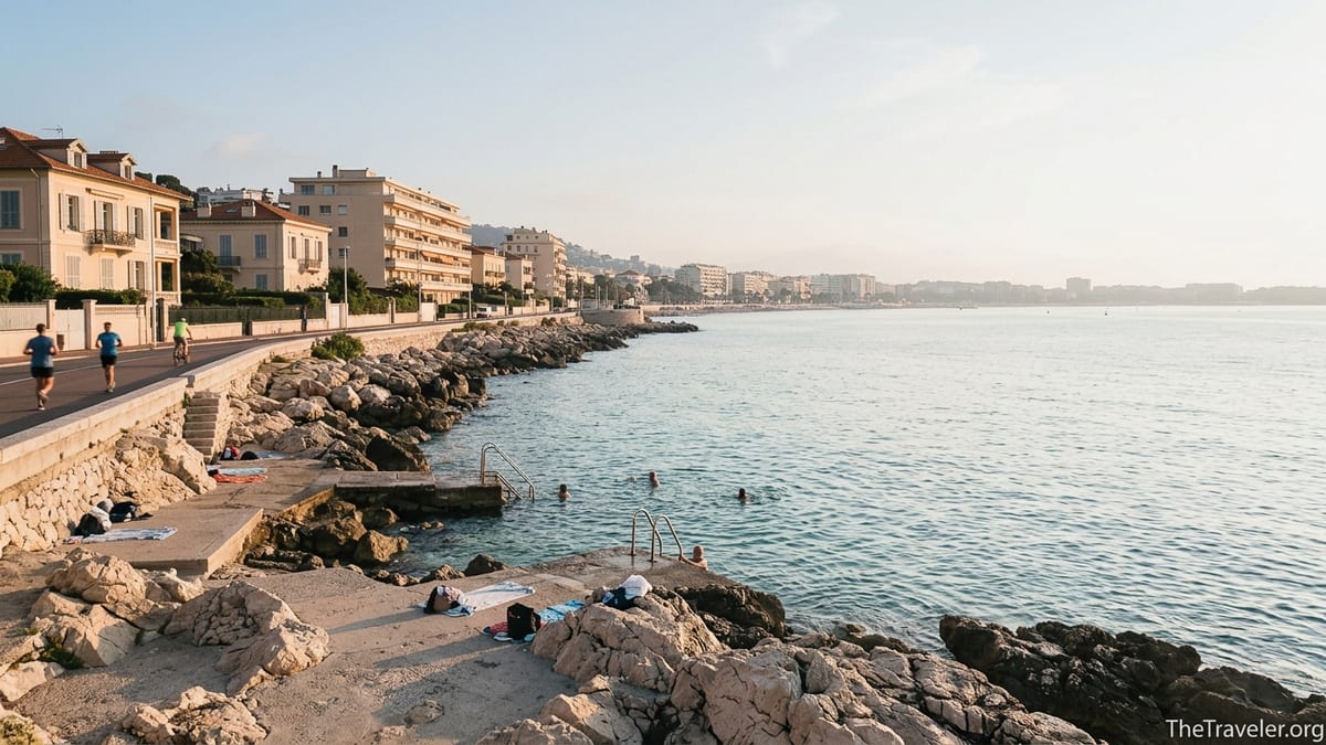
Hidden Corners off the Promenade: La Réserve, Bains Militaires and Neighborhood Beaches
Even right within the city, Baie des Anges hides pockets that feel surprisingly untouristic. One example is Plage de la Réserve, a tiny cove just before Coco Beach, mostly used by residents of the surrounding streets. From the road above, a flight of steps drops to a narrow strip of pebbles and rocks, usually dotted with towels and a few local families, especially outside the central school holidays.
A little further along you reach the platforms and ladders of Bains Militaires, named after the historic military swimming area. On warm evenings, local swimmers come straight from work, lock their bikes to the railings and slip into the water for twenty-minute laps before heading home. It is not the place for inflatables or big beach bags, but if you are traveling light and comfortable sitting on concrete ledges rather than hired loungers, the experience feels intensely “everyday Nice.”
These edges also illustrate another side of the bay that guidebooks seldom mention: water quality can vary along the port. Nice’s municipal services publish updates after heavy rain, and locals pay attention to flags and signs indicating when swimming is temporarily discouraged. Visitors who venture here should do the same, especially close to the port entrance, and be ready to move further along the coast if conditions look questionable after storms.
Further west along the Promenade, beyond the most crowded central segments opposite the old town, you start to see sparsely used portions of public beach. Between Gambetta and Magnan, for example, there are long pebbly stretches where weekday afternoons can feel almost empty in shoulder seasons like late April or late September. Visitors who only ever lie down in front of the big hotels miss out on these quieter pieces of exactly the same sea.
The Western Bay: Carras, La Lanterne and Everyday Riviera
Continue past Magnan toward the airport and the front becomes more residential. This western stretch of Baie des Anges between roughly Fabron and Nice’s border with Saint-Laurent-du-Var is where many locals actually swim on days off. The best known access point is Plage de Carras, next to a small harbour. It feels more utilitarian and less pretty than the central beaches, with aircraft approaching overhead, but that practical character comes with advantages.
For one, services here are geared toward residents rather than day-trippers. Small kiosks sell sandwiches, ice cream and reasonably priced soft drinks. A filled baguette from a bakery on Avenue de la Californie might cost 4 to 6 euros, compared with 10 to 15 euros for a club sandwich on a serviced beach closer to the Negresco. There is usually space to sit without having to rent a lounger, even in high season, and the general dress code is more relaxed.
Just west of Carras is a small stretch near the site known as La Lanterne, where a narrow beach allows dog owners to let their pets into the water, something prohibited on most of Nice’s seafront. If you are traveling with a dog and renting an apartment in this part of town, this little corner can make the difference between a frustrating and a enjoyable stay. Expect a rugged, unpolished environment: stones, some seaweed, and people who are there for their animals rather than the view.
Behind this western end of the bay, hillside districts like Fabron and Californie host most of the new residential developments with balconies overlooking Baie des Anges. Visitors usually only see these areas from a taxi window, but they are easy to reach by tram. An afternoon wandering up from the seafront into these neighborhoods offers a glimpse of everyday Nice: small supermarkets, pharmacies, local bistros with weekday lunch menus around 16 to 20 euros, and pocket parks with benches looking back toward the curve of the bay.
Western Gateways: Saint-Laurent-du-Var and Marina Baie des Anges
At the very western end of Baie des Anges, beyond the airport runways, the shoreline continues through Saint-Laurent-du-Var and Villeneuve-Loubet. Technically these are separate municipalities, but they belong to the same continuous bay and are easy additions to a Nice stay, especially if you have an early or late flight. A local train from Nice-Ville to Saint-Laurent-du-Var, for instance, often takes under ten minutes, and you can walk from the station to the seafront in another ten.
In Saint-Laurent-du-Var, the seafront promenade directly opposite the Cap 3000 shopping center is lined with restaurants and bars that mostly serve a regional French and Italian mix. Many of these places offer set lunch menus around 20 to 25 euros in 2026, and a kids’ menu under 12 euros is common, making it a practical stop for families before or after flights. The ambience is more suburban than glamorous, but the view back toward Nice, especially at sunset, reminds you that you are still looking across the same celebrated bay.
A few kilometres further west rises Marina Baie des Anges, the distinctive, terraced residential complex in Villeneuve-Loubet that looks like a pair of white pyramids when seen from the sea or from the air. Many visitors know the shape from aerial photos when landing in Nice but never realize they can walk among its landscaped gardens, restaurants and small marina. It is a curious piece of 1970s architecture that speaks of another phase in the bay’s development, when large-scale resorts and apartment complexes were seen as the future of coastal living.
Spending a half day around these western gateways gives you a different perspective on Baie des Anges. Here, the focus is less on grand hotels and more on marinas, families cycling along the promenade, and residents doing their weekly supermarket run in board shorts. For travelers who enjoy seeing how locals actually use a destination, this end of the bay can be unexpectedly rewarding.
Bay Views from Above: Colline du Château and Mont Boron
Another thing many visitors miss at Baie des Anges is the chance to see the entire bay from above, rather than only at sea level. The easiest viewpoint is Colline du Château, the historic park on the hill between the old town and the port. You can take the public elevator up from near the seafront or climb the staircase through the trees. At the top, paths and terraces open to sweeping views: westward along the curve of the Promenade and eastward toward the port and Cap de Nice.
Arriving shortly after sunrise or in the golden hour before sunset can be transformative. In the early morning, joggers and a few photographers share the park, and the bay below is quiet, with just a few swimmers in the pale blue water. In the evening, you often see small groups of locals who bring a simple picnic from a nearby supermarket or bakery rather than paying for a seafront restaurant. A baguette, some olives, a portion of local cheese and a bottle of supermarket rosé might total 15 to 20 euros and serve two or three people, compared with a multi-course restaurant dinner.
For a more offbeat vantage point, the wooded hill of Mont Boron rises above the eastern side of the bay. City buses take you close to the park entrance, from which signed trails lead to viewpoints looking back over Nice and across to the capes of Villefranche and Saint-Jean-Cap-Ferrat. On clear winter days you can sometimes see snow on distant Alpine peaks while the bay below glitters in soft light, a juxtaposition that helps explain why so many 19th-century visitors fell in love with this coast.
Mont Boron also connects by paths to Fort du Mont Alban, a 16th-century fortification that crowns the ridge between Nice and Villefranche-sur-Mer. The walk from the bus stop to the fort takes roughly twenty minutes uphill, and the reward is a full 360-degree panorama: Baie des Anges to one side, the deep natural harbour of Villefranche to the other, and the open Mediterranean beyond. It is one of the few places where you can grasp the true scale of the bay in a single slow turn.
Seasonal Rhythms and When the Bay Feels Most Local
Because Baie des Anges is attached to a working city of around 340,000 inhabitants, its character changes visibly with the seasons. Many visitors only know the high summer version, when private beaches run at full capacity, cruise passengers flood the old town, and late-night traffic hums along the Promenade until well after midnight. Yet local residents often say their favourite moments on the bay are in shoulder seasons such as late March, early May or October.
In these months, the sea is cooler but still swimmable for many people, and public beaches fill mostly with locals on days off rather than holidaymakers. You might see school groups on outings, workers taking a quick lunch break by the water and retirees reading on the blue chairs facing the bay. Prices on rental apartments are typically lower than in July or August, and it becomes easier to find a table at seafront brasseries without advance reservations.
Winter on Baie des Anges, while too chilly for casual swimming, can be atmospheric. Palm trees rustle in strong mistral winds, and waves break hard enough to close certain coastal paths for safety. Locals in coats and scarves still walk the Promenade, often stopping at kiosks for a hot chocolate instead of an ice cream. Hotel rates drop sharply around January, except during peak events such as the Nice Carnival or major conferences, giving budget-conscious travelers a chance to experience the bay’s famous light with far fewer crowds.
Understanding these rhythms can help you choose which side of the bay to explore. In peak summer, the more residential western stretches may feel calmer than the centre. In winter, sheltered corners by the port or under Cap de Nice can be more pleasant for a seaside walk than the fully exposed Promenade. In every season, venturing beyond the classic picture spot opens a more nuanced, human-scale Baie des Anges.
The Takeaway
Baie des Anges is not just a single spectacle to be admired from the Promenade des Anglais. It is a lived-in, layered shoreline where rocky coves, suburban marinas, hillside parks and everyday neighborhoods coexist along the same curve of sea. Visitors who confine themselves to the famous balcony of central Nice miss the quieter rooms of the house: Coco Beach’s ladders into deep water, the working quays of Port Lympia, the residential calm of Carras and Fabron, and the wide-angle vistas from Mont Boron.
By rethinking the bay as a sequence of distinct zones and by using simple tools like the tram, local buses and your own feet, you can experience a more authentic Riviera. That might mean a three-euro espresso on a port quay instead of a designer cocktail, a picnic above the bay instead of a seafront tasting menu, or a winter walk along the coastal path when the only other sound is the wind in the pines. In every case, the reward is the same: a sense that Baie des Anges belongs not only to postcards and luxury ads, but also to the daily life of the people who call this shore home.
FAQ
Q1. Where exactly does Baie des Anges begin and end?
The bay generally refers to the long curve of coastline from the Cap de Nice headland in the east of Nice to the area around Marina Baie des Anges near Villeneuve-Loubet in the west, encompassing the city seafront, the airport zone and nearby coastal towns.
Q2. Is Coco Beach suitable for families with small children?
Coco Beach is better for confident swimmers and adults. Access to the water is via rocks and ladders, there is little shade, and the sea becomes deep quickly. Families with young children often prefer the shallower, more gently sloping beaches in nearby Villefranche-sur-Mer or the central pebbly beaches where facilities are closer.
Q3. How can I reach the lesser-known western beaches like Carras and La Lanterne?
The easiest way is to take tram line 2 from central Nice toward the airport and get off at stops such as Carras or La Lanterne. From each stop it is usually a five to ten minute walk to the seafront. Standard city tickets cover these journeys, making them convenient half-day excursions.
Q4. Are there truly quiet spots along Baie des Anges in peak summer?
Absolute solitude is rare in July and August, but you can still find calmer stretches by walking west past Magnan toward Carras, or by using smaller coves like La Réserve in the early morning or near sunset. Residential areas at the edges of the bay tend to feel less crowded than the old town frontage.
Q5. Is it safe to walk the Cap de Nice coastal path?
In good weather and daylight the Cap de Nice section of the coastal path is well used and generally considered safe, with handrails and steps where needed. However, it is not recommended in heavy seas, during storms or at night. Proper footwear and a bottle of water are essential, and you should respect any temporary closures signaled by the authorities.
Q6. What is the best viewpoint over Baie des Anges for photos?
Colline du Château offers the classic wide-angle shot of the bay and the Promenade des Anglais and is easy to reach by elevator or stairs. For a more expansive and quieter panorama, head to Mont Boron or Fort du Mont Alban, which provide views not only over Baie des Anges but also toward Villefranche-sur-Mer and the surrounding capes.
Q7. Can I swim near Port Lympia?
Directly inside the port itself swimming is not allowed, but just beyond, at spots like Bains Militaires and Coco Beach, locals regularly swim in suitable conditions. It is important to check local notices and flags, particularly after heavy rain, because water quality can temporarily deteriorate near harbour areas.
Q8. Are there budget-friendly ways to enjoy the bay without paying for private beach clubs?
Yes. Public beaches run along much of the seafront and are free to use. You can bring your own towel, rent a low-cost beach mat from local shops and buy takeaway food from bakeries or supermarkets. Picnics in parks overlooking the bay, such as Colline du Château, are popular with locals and cost far less than a full restaurant meal.
Q9. How long should I plan to explore the less touristy parts of Baie des Anges?
A full day allows time to combine two or three contrasting areas, such as a morning walk at Cap de Nice, lunch at Port Lympia and an afternoon swim near Carras. With two or three days, you can add hilltop viewpoints, a visit to Saint-Laurent-du-Var or Marina Baie des Anges, and slower wanders through residential neighborhoods above the seafront.
Q10. Is it practical to explore Baie des Anges without a car?
It is very practical. Central Nice, the main beaches and Port Lympia are walkable, while tram line 2 connects the western bay and the airport. Regular buses link to Mont Boron, Fort du Mont Alban and neighboring towns. Trains along the coastal line make it easy to reach nearby stations such as Villefranche-sur-Mer, Saint-Laurent-du-Var and Villeneuve-Loubet without driving.