
Laurel Falls is one of the most talked-about hikes in Great Smoky Mountains National Park, frequently described as an easy, family-friendly walk to a postcard-perfect waterfall. That reputation draws hundreds of thousands of visitors each year, especially from nearby Gatlinburg. But how long does it really take to hike Laurel Falls, and is it genuinely easy for everyone, or just in comparison with the Smokies’ steeper mountain climbs? Here is a clear, realistic look at what to expect, grounded in current conditions on the trail.
Get the latest updates straight to your inbox!
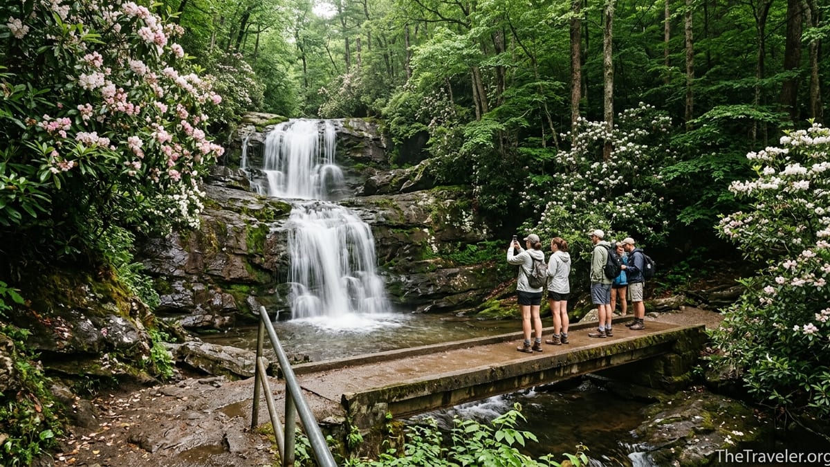
Laurel Falls At A Glance: Distance, Time And Current Status
Laurel Falls sits on the Tennessee side of Great Smoky Mountains National Park, a short drive from Sugarlands Visitor Center and downtown Gatlinburg. The classic waterfall viewpoint that most visitors are aiming for is roughly 1.3 miles from the trailhead, making the traditional out-and-back hike about 2.6 miles in total. The trail climbs gradually toward an 80-foot, two-tiered waterfall and crosses the creek on a narrow concrete footbridge right at the midpoint of the falls.
In practice, an average visitor should plan 1.5 to 2 hours for the round trip. Many park materials and regional hiking guides describe the route as taking about 2 hours, assuming a leisurely walking pace, time for photos at the falls, and a few breaks on the way up. Very fit hikers who are used to hills can complete the hike in closer to an hour and fifteen minutes, while multi-generational families, visitors adjusting to the humidity, or parents managing young children often use most of the 2-hour window.
The elevation gain on the standard Laurel Falls route is usually listed at around 300 feet over those 1.3 miles to the falls. That is modest compared with leg-burning Smokies hikes like Alum Cave, Rainbow Falls or Mount LeConte, where you can climb 2,500 to 4,000 feet in a single outing. Here, the climb is steady rather than steep, and the surface is mainly paved for the most popular section, which is why many brochures still refer to Laurel Falls as “easy.”
However, travelers planning a visit in 2025 or 2026 need to be aware of a crucial detail: the National Park Service has closed the Laurel Falls Trail from January 6, 2025, for an 18‑month rehabilitation project. That means the classic 2.6‑mile out‑and‑back route to the waterfall viewpoint is not accessible during this construction period. If you are reading this while planning a trip for summer 2025 or spring 2026, you will need a backup waterfall hike such as Cataract Falls (near Sugarlands), Grotto Falls, or Indian Creek Falls instead, and should check the latest park advisory just before your visit to confirm reopening timelines.
How Long The Hike Takes For Different Types Of Visitors
Even when a trail is short and heavily visited, the actual time it takes varies a lot from person to person. On Laurel Falls, timing differences usually come down to three main factors: fitness level, how often you stop, and how crowded the trail is during your visit.
For a reasonably active adult or couple, walking at a moderate pace with short pauses to catch breath and take a few photos, 35 to 45 minutes is a typical time from the parking lot to the falls. Add another 15 to 20 minutes at the falls to enjoy the view and carefully navigate the often slick rocks around the bridge. The return trip is mostly downhill and usually takes 25 to 35 minutes. That means 75 to 100 minutes is realistic for many visitors on a normal day.
Families with young children or grandparents in the group should budget longer. On busy summer weekends, it is common to see strollers, toddlers who insist on walking themselves, and hikers who need frequent water breaks. A family might spend an hour on the way up alone, especially if children are fascinated by salamanders in the damp rock walls, blooming mountain laurel in late May and early June, or patches of ice after a cold snap in winter. Once you build in time for snacks at the waterfall, photos of the kids on the bridge, and a slower descent to protect knees and hips, the outing can easily stretch to the full 2 hours.
Crowds add another layer. Laurel Falls is one of the most popular short hikes in the Smokies, and on peak days in June, July, and October, the trail often feels like a continuous chain of people. Narrow sections of pavement make it necessary to pause and let people pass one direction at a time, and at the falls itself, groups queue informally to stand on the bridge for photos. All of that start-and-stop movement adds minutes. Someone who could normally walk 2.6 miles in an hour might spend 30 extra minutes simply waiting for space to move or for a chance to take a picture.
Is Laurel Falls Really An Easy Hike?
The word “easy” gets used a lot in connection with Laurel Falls, but how it feels depends on your expectations and your starting point. Compared with steeper Smokies trails like Rainbow Falls or Chimney Tops, the Laurel Falls route is certainly kinder. The grade is moderate, the surface is mostly paved, and you are not gaining thousands of feet of elevation. Many visitors who could not manage a strenuous mountain climb can, with care, complete this hike.
At the same time, it is not the same as a flat city sidewalk or an urban greenway. From the trailhead, the pavement climbs almost continuously. In places, the asphalt is cracked or eroded, with exposed rocks and patches of uneven footing. On hot afternoons in July and August, humidity can be intense, and visitors from lower, drier regions often find that they need more water and more rest stops than they anticipated, even on this relatively short walk.
For someone who walks several miles a week at home and is comfortable with gentle hills, the hike will usually feel easy to moderate. A real-world example: a visitor staying three nights in Gatlinburg, who normally walks 3 miles on suburban sidewalks a few times a week, might use Laurel Falls as a “warm‑up” hike on day one. They climb at a steady pace, arrive at the falls in about 40 minutes, and feel pleasantly tired but not exhausted when they return to their car.
For someone with limited mobility, heart or breathing issues, or joint pain, the same trail can be challenging. The continuous gain means there is almost no true flat section to recover on, and there are drops off the side of the trail in places where there are no guardrails. Parents often comment that they need to hold the hands of small children closely in those spots. For these groups, a shorter, flatter alternative like the 0.7‑mile round‑trip walk to Cataract Falls behind Sugarlands Visitor Center may genuinely feel “easy,” while Laurel Falls feels more like a solid workout.
Trail Conditions, Elevation And Safety Considerations
Trail condition plays a big role in both the time and difficulty of any hike. On Laurel Falls, the most noticeable feature is the paved surface. The first 1.3 miles of the route from the Fighting Creek Gap Road trailhead to the waterfall have been paved to handle heavy foot traffic and reduce erosion. That paving leads many first-time visitors to imagine a smooth, completely accessible pathway. In reality, decades of freeze-thaw cycles, roots, and water run-off have left the surface cracked, sloped and occasionally broken in places. You will still need sturdy, closed-toe footwear with some grip.
Elevation gain to the falls is often quoted at about 300 feet, which sounds modest, but it is gained steadily. There are no big stair sections, yet you are rarely walking flat. People who are unused to hills quickly notice the difference. Because the trail winds in and out of shade, microclimates can vary: one bend might be cool and damp with moss-covered rocks, the next sunny and noticeably warmer. In late fall and winter, shaded patches can hold ice long after sunny sections have thawed.
Safety is another reason this short hike deserves respect. Steep drop-offs line sections of the trail, and there are few railings. The footbridge at the falls can be wet and slick, especially after rain. It is common to see visitors in flip-flops or carrying infants in their arms, but rangers regularly caution that even this “easy” hike has seen slips and falls. A cautious approach looks more like this: proper walking shoes or light hiking boots, a small daypack with at least one water bottle per person, and a willingness to slow down in congested areas rather than trying to squeeze around other hikers on the outside edge of the trail.
Because Laurel Falls is so popular, the park has put effort into managing congestion and improving the visitor experience. Pilot projects in recent years have explored timed-entry parking and shuttle options from Gatlinburg. The current 18‑month trail closure is part of a larger rehabilitation plan that includes upgrades to the trail surface and viewing areas. Once the work is finished, the trail should be safer and better able to withstand the heavy use it receives each year, but visitors should still treat it as a real hike rather than an amusement-park stroll.
Crowds, Parking And How Timing Affects Your Experience
The reputation of Laurel Falls as a short, scenic hike close to Gatlinburg means crowds are almost guaranteed during the main visitor seasons. On a sunny June Saturday, the small trailhead parking lot on Fighting Creek Gap Road typically fills very early in the morning, and by mid-morning cars may be circling or turning around to look for other hikes. Rangers have installed barriers along the roadside to prevent unsafe overflow parking, so simply pulling onto a shoulder is often not an option.
In recent years, some visitors have tried to time their hike slightly outside the busiest hours. For example, arriving before 8 a.m. often gives you a reasonable shot at a parking space and a somewhat quieter walk up to the falls before tour groups and mid-morning traffic arrive. Others deliberately start in the late afternoon, between 4 and 5 p.m., when many day-trippers have already left for early dinners in Gatlinburg. That strategy can work in summer when daylight lasts well into the evening, but you must be confident that everyone in your group can complete the hike before dark.
Crowds at the falls themselves can directly affect how long the outing takes. On peak days, it is normal to wait several minutes to step onto the narrow bridge for a photo. People often gather on both sides of the bridge and along the rocks by the upper cascade, which limits how much room there is for safe movement. If you are hoping for quiet time to watch the water or take long-exposure photographs with a tripod, consider a weekday in late fall or early spring when visitation dips. Cooler air and smaller crowds can transform the same 2.6‑mile hike from a slow shuffle into a relaxed, scenic walk.
When the trail reopens after its current rehabilitation, it is possible that shuttle services from Gatlinburg or Sugarlands Visitor Center will play a larger role in managing access. Even now, Gatlinburg-based tour operators sometimes include a stop at Laurel Falls as part of half-day guided outings, bundling transportation and scheduling for you. That can reduce parking stress, though you may pay a premium compared with driving yourself and you are tied to the group’s timetable.
Seasonal Factors: Weather, Water Levels And Best Times To Go
Season and weather change both the difficulty and the character of the Laurel Falls hike. In spring, usually from late April into early June, the trail’s namesake mountain laurel blooms along the route, adding white and pink blossoms around the path. Temperatures are milder than in midsummer, though afternoon showers are common. Wet pavement and rocks can be slick, but if you bring a lightweight rain jacket and take your time, this is one of the most rewarding periods to visit.
Summer brings lush greenery and higher water flow at the falls, but also the highest humidity and the largest crowds. A mid-July hike can feel significantly harder than the same walk in October simply because of the heat index. Visitors staying in air-conditioned cabins around Gatlinburg sometimes underestimate how quickly they will sweat once they start climbing. Hydration and sun protection become more important, especially for children and older adults.
Fall, particularly October, is another peak time, thanks to the Smokies’ famous foliage. The forest around Laurel Falls glows with gold and red tones when conditions are right. Temperatures are generally comfortable, which can make the uphill walk feel easier, but parking competition is intense, especially on weekends when leaf peeping is at its peak. If you can plan a midweek hike or arrive right after sunrise, you will still have a better experience.
Winter is quieter, and on days when Fighting Creek Gap Road is open and conditions are dry, fit hikers with proper traction sometimes make the hike to enjoy bare-tree views and a partially frozen waterfall. However, ice on the shaded pavement and bridge can make footing treacherous. Even if the air temperature feels manageable, patches of black ice can linger. It is not a good season for casual visitors in smooth-soled shoes. As always, check current road and trail advisories with the park before attempting a winter visit.
Planning Your Visit: Gear, Expectations And Alternatives
A successful outing to Laurel Falls starts with setting realistic expectations. Think of it as a short but genuine mountain hike. That means dressing in comfortable, moisture-wicking layers, wearing sturdy walking shoes or trail runners with tread, and carrying at least a small daypack. Inside, pack water for everyone in your group, a few snacks, and basic items like sunscreen, a hat, and a light rain shell. You do not need heavy-duty backcountry gear, but you will be more comfortable if you treat this like more than a stroll around a city park.
Time your arrival with your own habits in mind. If you are a morning person who likes quieter trails, aim to be pulling into Sugarlands Visitor Center around 7:30 a.m., with the goal of reaching the Laurel Falls trailhead shortly thereafter. If you are not an early riser, consider whether a late-afternoon start fits your schedule and the season’s daylight. Remember that Great Smoky Mountains National Park requires a paid parking tag for most parking longer than 15 minutes, which you can purchase in advance or at the visitor center before heading up to the trailhead.
Because the Laurel Falls Trail is undergoing a lengthy closure into mid-2026, think about it in the context of a broader Smokies waterfall itinerary. Alternatives with similar “short hike, big payoff” value include Grotto Falls off the Roaring Fork Motor Nature Trail, where you can walk behind a curtain of water, and Abrams Falls near Cades Cove, which is longer and rated moderate but offers a powerful 20‑foot waterfall. For visitors with mobility challenges, the flat paths and exhibits near Sugarlands Visitor Center or the drive-up overlooks along Newfound Gap Road can provide mountain views without the climb.
Once the rehabilitation is complete, Laurel Falls will likely resume its role as many travelers’ first Smokies hike, an introduction to the park’s lush ravines and tumbling streams. With a realistically planned schedule, decent footwear, and respect for the terrain, most visitors will continue to find that the hike is on the easier end of the Smokies spectrum, even if it is not effortless.
The Takeaway
So how long does it take to hike Laurel Falls, and is it really easy? Under typical conditions, most visitors should plan about 1.5 to 2 hours for the 2.6‑mile round trip, including time to enjoy the waterfall. For active travelers used to walking, the gradual 300‑foot climb on a mostly paved surface feels easy to moderate. For families with small children, people unaccustomed to hills, or anyone sensitive to heat and humidity, it can feel like a solid but manageable workout.
“Easy” in the Smokies still means respecting real mountain terrain: uneven pavement, slick rocks, drop-offs without railings, and crowds that slow your pace. Treat Laurel Falls as a short hike rather than an amusement-park attraction, and you will be more likely to enjoy the experience and to finish with enough energy to explore more of Great Smoky Mountains National Park afterward.
If you are traveling in 2025 or early 2026, remember that the Laurel Falls Trail is temporarily closed for major improvements, and you will need to choose alternative waterfalls for now. Once the trail reopens, it will likely be better prepared to welcome the next wave of hikers looking for that iconic Smokies waterfall experience at the end of an approachable, family-friendly walk.
FAQ
Q1. How long does it usually take to hike to Laurel Falls and back?
Most visitors should allow 1.5 to 2 hours for the 2.6‑mile round trip, including time to rest, take photos at the falls, and navigate any crowds.
Q2. Is the Laurel Falls hike suitable for young children and older adults?
Yes for many families, but it depends on mobility. The hike is short with moderate elevation gain, yet the uphill grade, uneven pavement, and drop-offs require close supervision and steady balance.
Q3. Is the trail to Laurel Falls fully paved and stroller-friendly?
The main section to the falls is paved, but the surface is cracked and uneven in places, with slopes and narrow sections. Lightweight strollers with good wheels can work, but many parents find child carriers safer and more practical.
Q4. When is the best time of day to hike Laurel Falls to avoid crowds?
Arriving early, typically before 8 a.m., or hiking in the late afternoon on longer summer days offers the best chance for fewer crowds and easier parking.
Q5. What should I wear and bring for the Laurel Falls hike?
Wear sturdy walking shoes or light hiking shoes with good traction, and bring water, snacks, sun protection, and a light rain layer. A small daypack is enough for most visitors.
Q6. Is Laurel Falls open year-round?
In a typical year the trail can be hiked in all seasons, weather and road conditions permitting, but it is currently closed for an extended rehabilitation project that began in January 2025. Always check the latest park alerts before visiting.
Q7. Do I need a parking tag or permit to hike Laurel Falls?
Great Smoky Mountains National Park requires a paid parking tag for most vehicles parked longer than 15 minutes, including at popular trailheads like Laurel Falls. You can purchase tags at visitor centers and select kiosks.
Q8. Are there restrooms or water fountains at the Laurel Falls trailhead?
There are no restrooms or drinking water at the trailhead itself. Plan to use facilities and refill water bottles at Sugarlands Visitor Center before driving to the parking area.
Q9. How does Laurel Falls compare to other short waterfall hikes in the Smokies?
Laurel Falls is shorter and more paved than many hikes, which makes it feel easier than routes like Abrams Falls or Rainbow Falls. However, trails such as Cataract Falls near Sugarlands are flatter and may feel easier for visitors with limited mobility.
Q10. What should I do if Laurel Falls is closed during my visit?
If the trail is closed, consider alternative waterfall hikes such as Grotto Falls, Cataract Falls, or Indian Creek Falls, and ask rangers at Sugarlands Visitor Center for current recommendations based on your group’s abilities.