
Two waterfall hikes dominate most first-time wish lists in Great Smoky Mountains National Park: the short, paved walk to Laurel Falls and the longer forest trail to Abrams Falls in Cades Cove. Both promise classic Smokies scenery, rushing water and plenty of photo opportunities, but they deliver very different kinds of experiences. With recent changes in trail conditions and park management, the better choice in 2026 depends as much on your expectations and travel style as it does on mileage and elevation gain.
Get the latest updates straight to your inbox!
Current Status in 2026: A Crucial First Difference
Before comparing scenery or difficulty, it is important to understand what is actually open in 2026. As of early 2025, the National Park Service closed the Laurel Falls Trail for an approximately 18‑month rehabilitation project that includes safety upgrades and parking improvements. That means through at least mid‑2026 many visitors coming for the famous paved walk to the falls will find the trail closed and construction active around the trailhead. In practical terms, if you are planning a trip for spring or early summer 2026, Abrams Falls is likely to be the only one of these two marquee waterfall hikes that is reliably accessible.
The closure at Laurel Falls is not a minor inconvenience. The trail had been drawing more than 300,000 visitors a year, making it one of the most heavily used paths in the Smokies. Park rangers reported issues ranging from crumbling pavement and eroded shoulders to crowding at the narrow bridge in front of the falls. The rehabilitation is designed to address these problems and may include refined viewing areas and expanded, more orderly parking once the trail reopens.
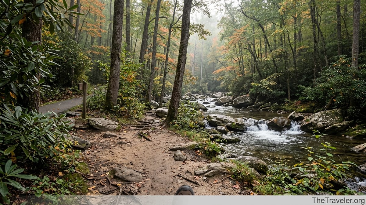
Abrams Falls, on the other hand, remains open and operating as normal from its trailhead in Cades Cove. The park has focused on signage and education there rather than closures, in part because the route is a traditional dirt trail with rolling elevation rather than a deteriorating paved path. For travelers visiting while Laurel Falls is under construction, Abrams Falls becomes the more realistic choice simply because it is available.
If your trip is scheduled for late 2026 or beyond, check the most recent park updates shortly before you arrive. Trail work timelines in mountain environments can shift with weather, funding and construction logistics, so it is always wise to verify whether Laurel Falls has fully reopened or is still partly restricted.
Trail Basics: Distance, Elevation and Time Commitment
When both hikes are open, the most obvious contrast is distance and the kind of effort each trail requires. Laurel Falls is a 2.6‑mile round‑trip route from the roadside trailhead on Little River Road to the main waterfall viewpoint and back. The first 1.3 miles to the falls are paved, with a steady but relatively gentle climb of just over 300 feet in elevation. Most reasonably active visitors complete the hike in 1.5 to 2 hours, including time for photos at the falls.
Abrams Falls is a more substantial outing. The standard out‑and‑back route from the trailhead at stop 10 on the Cades Cove Loop is roughly 5 miles round‑trip. Depending on the guide you consult, the elevation gain is often listed between about 600 and 750 feet, but it is spread across a series of short climbs and descents rather than one continuous grade. Most hikers should plan 3 to 4 hours for this hike, especially if they want time to enjoy the falls and navigate crowded sections on busy days.
For families traveling with very young children, grandparents or anyone with limited time in the park, Laurel Falls, once it reopens, remains the lower‑commitment option. You can leave a hotel in Gatlinburg after breakfast, drive 20 minutes to the trailhead, complete the hike and still have time for an afternoon scenic drive or another short stroll. Abrams Falls is better suited as the main activity for half a day, paired perhaps with a loop around Cades Cove by car or bike.
The difference in commitment also affects how you plan meals and logistics. For Laurel Falls, many visitors simply bring a water bottle and perhaps a snack bar. For Abrams Falls, experienced hikers commonly bring a daypack with at least one liter of water per person, light rain gear and more substantial snacks. In summer, when humidity in the Smokies can feel intense, the extra distance on Abrams means that under‑prepared hikers are more likely to feel overheated or fatigued.
Scenery and Atmosphere: Paved Popularity vs Forest Immersion
Scenery is subjective, but the character of these two hikes is distinctly different. Laurel Falls is about quick payoff: within the first 15 minutes the trail delivers open views across the forested slopes of Cove Mountain, and the path is constantly framed by mountain laurel and rhododendron. The waterfall itself is an 80‑foot cascade split into upper and lower sections, with a photogenic footbridge crossing at the divide. When water levels are healthy, it is a dramatic sight, especially in late April or early May when the surrounding laurel shrubs begin to bloom.
The atmosphere at Laurel Falls, however, is often busy, especially on weekends and during peak summer and fall foliage periods. On a Saturday in July it is common to share the narrow bridge and viewing area with dozens of other hikers at once, many of them families corralling small children or visitors in street shoes filming on their phones. Conversations in multiple languages, the beeping of cameras and the occasional bark of a small dog near the parking area all contribute to a social, almost urban‑park feel rather than a remote wilderness vibe.
Abrams Falls offers a different type of scenic experience. The trail quickly leaves the parking lot and rolls through classic Smokies forest, mixing pine, oak, hemlock and dense rhododendron thickets. Much of the route follows alongside Abrams Creek, with repeated glimpses of clear, fast‑moving water over rounded boulders. In spring, wildflowers dot the trail edges; in autumn, the hardwoods in Cades Cove light up in deep reds, oranges and golds, reflecting in quiet pools along the creek.
The waterfall at Abrams is only about 20 feet tall, far shorter than Laurel Falls, but it compensates with sheer volume. A wide curtain of water pours into a large plunge pool, creating a low, steady roar that you can hear as you approach. The area feels more enclosed and natural, with no paved viewing platform or bridge. On busy days it still draws crowds, but because of the longer hike, the number of visitors at any one time is usually lower, and the hike in feels more like a journey through the forest than a short promenade.
Accessibility, Safety and Who Each Hike Suits Best
One of the reasons Laurel Falls became so popular is its partial accessibility. The paved surface and relatively short distance made it appealing to visitors who might not otherwise attempt a mountain trail. Parents with school‑age children, older travelers who can handle a modest incline, and even some visitors using strollers or mobility aids during dry conditions have all used this path. That said, the pavement is cracked and uneven in places, which is part of what the current rehabilitation aims to improve, and the final approach to the falls includes steeper sections and drop‑offs that demand attention.
Abrams Falls is a traditional dirt hiking trail with rocks, roots and several narrow sections along steep slopes. It is rated moderate, but some visitors find it closer to moderately strenuous, especially in summer heat or if they are unused to hiking. The surface can become muddy and slick after rain, and there are a few short but noticeable climbs on both the outbound and return legs. This hike is not suitable for strollers, and it can be challenging for visitors with knee issues or poor balance.
Safety considerations are also different at each destination. At Laurel Falls, the main concerns are crowding at the narrow bridge and the temptation to step off the path for photos near steep drop‑offs. Park rangers regularly warn visitors not to climb rocks adjacent to the falls or let children run ahead on the upper section. At Abrams Falls, the hazard is the plunge pool. Despite signs and repeated advisories, some visitors attempt to swim close to the base of the falls or wade where currents are deceptively strong. Over the years, several drownings and serious incidents have occurred here, often involving strong swimmers caught off guard by the turbulence near the falls.
In practical terms, Laurel Falls is better for visitors who want a relatively accessible outing with guardrails, paved surfaces and frequent company on the trail. Abrams Falls is a stronger match for reasonably fit hikers who are comfortable on uneven terrain and prefer the feeling of being more deeply immersed in the forest. Families with energetic older kids who already enjoy hiking often find Abrams rewarding, especially when paired with wildlife spotting in Cades Cove before or after the hike.
Logistics: Parking, Crowds and Seasonal Tips
For both hikes, logistics can shape your experience as much as the terrain. Laurel Falls sits on Little River Road between the Sugarlands Visitor Center and the Elkmont area, a corridor that already sees heavy traffic. The main trailhead lot has fewer than 40 official spaces, and parking along the roadside has been restricted by barriers in recent years. Since 2023, Great Smoky Mountains National Park has also implemented its Park It Forward program, which requires a paid parking tag for most vehicles stopping longer than 15 minutes in the park. In 2026, a daily tag for a standard vehicle is approximately 5 dollars, with longer‑term options available for travelers spending several days in the area.
In addition to the parking tag, the park and several private operators promote shuttle services from gateway communities like Gatlinburg and Townsend. It is increasingly common for visitors staying in Gatlinburg to leave their car at a hotel or public lot and book a morning shuttle that stops at popular trailheads such as Laurel Falls, Alum Cave and Clingmans Dome. While this adds cost, it can remove the stress of circling for a spot on crowded weekends and eliminates the risk of an expensive parking citation for stopping in a signed no‑parking zone.
Abrams Falls requires a different sort of planning. The trailhead is on the Cades Cove Loop Road, about an hour’s drive from Gatlinburg when traffic is light. During peak seasons, especially summer and October foliage weekends, the one‑way loop can slow to a crawl as visitors pause to view deer, black bears or historic cabins. On Wednesdays from late spring through fall, the park often closes the loop to vehicle traffic during the morning or full day to allow cyclists and pedestrians to enjoy it without cars. That is excellent for visitors who want to bike the loop, but it can complicate timing for those planning to drive to the Abrams Falls trailhead.
The most reliable strategy for both hikes is to start early. At Laurel Falls, arriving at the trailhead by 8 a.m. during peak months significantly improves your odds of finding a legal parking spot and enjoying the falls with a bit more elbow room. At Abrams Falls, entering Cades Cove early in the morning lets you complete the hike before midday heat and before the heaviest traffic builds on the loop. Many experienced Smokies visitors combine a dawn wildlife drive through the fields, a mid‑morning hike to Abrams, and a picnic lunch before exiting the cove.
Weather, Seasons and Wildlife: When Each Hike Shines
Both waterfalls are technically accessible year‑round, but their character shifts with the seasons. In early spring, Laurel Falls can feel particularly lush as new leaves emerge and mountain laurel buds appear along the trail. Water flow tends to be strong from late winter snowmelt and spring rains, and cooler air temperatures make the short climb pleasant even in the middle of the day. Summer brings dense greenery and warmer, more humid conditions, while late October often paints the surrounding ridges with fall color.
Abrams Falls responds even more dramatically to the seasons because of its length and proximity to Cades Cove. In April and May, the forest floor along the trail hosts trillium, violets and other wildflowers. In midsummer, the shade from tall hardwoods and hemlocks helps buffer the heat, though the humidity can still be intense. The real show, however, is autumn. From late September into late October, the slopes above Abrams Creek and the cove valley burst into orange and red, and on still mornings, the creek carries mirrored reflections of colored leaves between its boulders.
Wildlife encounters are also different between the two routes. Laurel Falls lies along a busy corridor where bears, while present in the broader area, are less frequently seen right at the trail due to human activity. The most common sightings tend to be songbirds, squirrels and occasional deer near the trailhead. Abrams Falls, accessed through Cades Cove, sits in one of the richest wildlife areas in the park. On the drive to the trailhead you may see wild turkeys striding through open fields, white‑tailed deer browsing at the forest edge, and, during certain seasons, black bears foraging for berries or acorns. Inside the forest itself, chipmunks, woodpeckers and kingfishers along Abrams Creek are regular companions.
Regardless of season, pack rain gear and be prepared for sudden changes. The Great Smoky Mountains earn their name from frequent mist and fast‑moving storms. A sunny morning in Gatlinburg does not guarantee dry conditions on the trail. On Abrams Falls in particular, a short downpour can quickly turn dry sections muddy and make rock steps slick. Footwear with good traction and a cautious pace are your best defenses against a twisted ankle or slip on wet rock.
Which Waterfall Hike Delivers the Better Overall Experience?
Choosing the better experience between Laurel Falls and Abrams Falls ultimately comes down to what you value most in a hike. If your ideal day in the Smokies involves a short, relatively accessible walk to a tall, photogenic waterfall with minimal time investment, Laurel Falls is hard to beat when it is open and in good condition. Its paved path, dramatic 80‑foot cascade and proximity to Gatlinburg make it perfectly suited to travelers who are squeezing hiking between other activities like visiting Dollywood or strolling the shops and restaurants downtown.
If, on the other hand, your vision of a great waterfall hike includes a few hours on a forested trail, the sound of a creek alongside you, and a destination that feels more like a natural amphitheater than a developed viewpoint, Abrams Falls is the stronger choice. The falls themselves, while shorter, impress with their power and the size of the plunge pool, and the approach through Cades Cove provides a sense of immersion in the national park that a quick stop at a roadside lot cannot match.
In 2026 specifically, the scales tilt further toward Abrams Falls because of the extended closure and construction at Laurel Falls. Travelers arriving expecting the classic paved hike may find fencing, construction equipment and “Trail Closed” signs instead. Those who pivot to Abrams, or plan it as their primary waterfall hike from the start, are more likely to enjoy an outing that matches their expectations.
For many visitors, the best scenario is not choosing one over the other but doing both on different days when Laurel Falls has fully reopened. Start with Laurel Falls early one morning to get a taste of Smokies waterfalls with minimal commitment. Then, once you are comfortable with the terrain and conditions, plan a half‑day for Abrams Falls and Cades Cove to experience the park at a deeper level. Taken together, the two hikes offer a compelling introduction to why the Smokies are among the most visited mountains in the United States.
The Takeaway
Laurel Falls and Abrams Falls each deliver a classic Smokies waterfall experience, but they cater to different types of travelers. Laurel Falls is short, partly paved and close to Gatlinburg, best for visitors who want quick access to a tall, postcard‑worthy cascade and do not mind sharing the trail with many others. Abrams Falls is longer, rougher underfoot and rooted firmly in the wilder feel of Cades Cove, making it ideal for hikers willing to devote half a day to a more immersive forest and creek journey.
Given the current multi‑season rehabilitation work at Laurel Falls, travelers visiting in 2026 should treat Abrams Falls as the more reliable option and check for updated trail conditions at a visitor center or on the park’s official channels just before their trip. Those who arrive prepared with sturdy footwear, sufficient water, a parking tag and realistic expectations about crowds will find either hike rewarding in its own way.
In the end, the better waterfall hike is the one that best matches your time, fitness and appetite for adventure. If you have only a couple of hours and want a paved path with big views, choose Laurel Falls once it reopens. If you prefer a longer, moderately challenging trail with powerful water and a richer sense of being in the mountains, lace up your boots for Abrams Falls and savor the sound of Abrams Creek guiding you through the forest.
FAQ
Q1. Is Laurel Falls open in 2026?
As of mid‑2026, Laurel Falls has been closed since January 2025 for about 18 months of trail rehabilitation, so access may still be restricted. Always confirm the latest status with the park shortly before your visit.
Q2. How difficult is the Abrams Falls hike compared to Laurel Falls?
Abrams Falls is roughly 5 miles round‑trip with rolling elevation and uneven terrain, generally rated moderate and more demanding than the 2.6‑mile, partly paved Laurel Falls trail.
Q3. Can young children hike to Abrams Falls safely?
Many families hike to Abrams Falls with school‑age children who are used to trails. Parents should be prepared for roots, rocks and short climbs, keep kids close near drop‑offs, and strictly prevent them from swimming near the base of the falls.
Q4. Do I need a parking reservation or permit for these hikes?
You do not need a timed reservation for either trail, but you must display a valid Great Smoky Mountains National Park parking tag if your vehicle is parked for more than a brief stop.
Q5. Are pets allowed on the Laurel Falls or Abrams Falls trails?
No. Pets are not allowed on most Smokies hiking trails, including both Laurel Falls and Abrams Falls. They are permitted on certain roads and a few designated paths only.
Q6. What kind of footwear is best for each hike?
For Laurel Falls, sturdy walking shoes with good grip are usually sufficient in dry weather. For Abrams Falls, lightweight hiking shoes or boots with solid traction are strongly recommended due to rocks, roots and possible mud.
Q7. Can I swim at Laurel Falls or Abrams Falls?
Swimming is strongly discouraged at both waterfalls, especially at Abrams Falls. The plunge pool there has powerful currents, hidden rocks and a history of serious accidents and drownings.
Q8. When is the best time of day to hike these trails?
Early morning is usually best for both hikes. You will encounter cooler temperatures, better chances of finding legal parking and slightly lighter crowds at the falls themselves.
Q9. How long should I plan for each hike, including driving?
From Gatlinburg, Laurel Falls typically takes about 3 hours door to door, including the short drive and time at the falls. Abrams Falls from Gatlinburg often requires 5 to 6 hours once you factor in the drive into Cades Cove, potential traffic on the loop and a relaxed pace on the trail.
Q10. If I only have time for one waterfall hike, which should I choose?
If you prefer a short, accessible outing close to town and the trail is open, choose Laurel Falls. If you want a longer, more immersive forest hike with a powerful creek and are comfortable with moderate effort, Abrams Falls is the better choice.