
Ask a ranger at Great Smoky Mountains National Park what goes wrong at Laurel Falls, and you will hear the same pattern again and again. The issues that lead to miserable hikes, frayed tempers, damaged cars, and occasionally serious injuries usually start long before anyone reaches the waterfall. The biggest mistake most visitors make at Laurel Falls happens before they even see the trailhead: they underestimate the logistics. From parking and timing to current trail closures and crowd levels, poor planning turns what should be a gentle family hike to an 80 foot waterfall into one of the most stressful experiences of a Smokies vacation.
Get the latest updates straight to your inbox!
Laurel Falls Today: What Most Visitors Miss Before They Arrive
Laurel Falls is one of the most popular destinations in Great Smoky Mountains National Park, drawing hundreds of thousands of visitors in a typical year for a short, paved walk to an 80 foot cascade tucked into the forest above Little River Road. On paper the hike sounds simple: roughly 2.6 miles round trip on a relatively gentle grade that many guidebooks describe as family friendly. That quick summary is what lures busloads of casual hikers from Gatlinburg and Pigeon Forge, often with little thought for timing, conditions, or crowding.
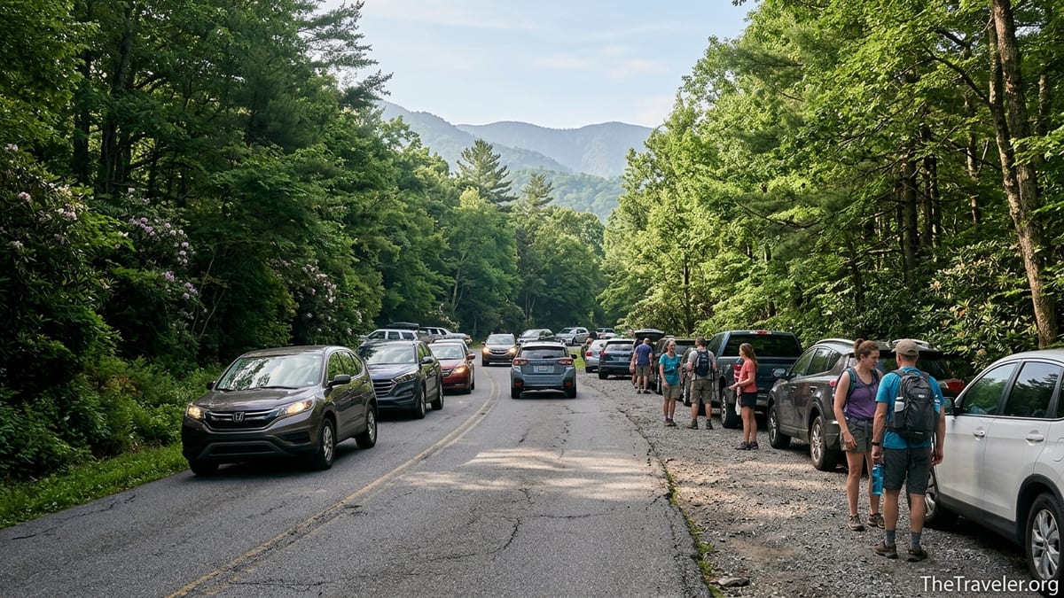
In reality, Laurel Falls has become a case study in what can go wrong when a beautiful place collides with heavy visitation. On busy weekends, the small parking area at Fighting Creek Gap fills early, traffic slows to a crawl along Little River Road, and families circle repeatedly looking for a space while kids grow restless in the back seat. Many arrive without having checked current conditions, not realizing that as of early 2025 the National Park Service has closed the trail for an extended rehabilitation project, forcing would be hikers to turn around and improvise a new plan for the day.
The details of that closure matter. According to recent park updates, the Laurel Falls Trail is shut from the trailhead on Fighting Creek Gap Road up to the junction with the Little Greenbrier and Cove Mountain trails for roughly 18 months of construction work, meaning no legal access to the waterfall viewpoint during that window. Visitors who booked cabins in Gatlinburg on the assumption that Laurel Falls would be their easy first day walk have been pulling into the lot, seeing closed signs and construction fencing, and discovering that their centerpiece hike is off the table. The common denominator is that most never checked the park’s current conditions page before leaving town.
Even when the trail is open, underestimating what you will encounter at Laurel Falls remains the core mistake. Many people assume that a short, paved trail in a national park will feel like a wide suburban greenway. Instead, pavement at Laurel Falls is narrow, broken in places, and perched above steep drop offs, with crowds funneled into tight bottle necks near the falls. Add in the fact that parking rules, shuttle options, and congestion management experiments have changed several times in recent years, and it becomes clear that spending a few minutes on research before you go is not optional. It is the difference between a relaxed half day outing and a frustrating brush with the worst of Smokies traffic.
The Real Problem: Underestimating Parking, Timing, and Current Conditions
When rangers and long time locals talk about the biggest mistake at Laurel Falls, they rarely start with footwear or water bottles. They talk about timing and expectations. The most common misstep is assuming you can drive out from downtown Gatlinburg late in the morning, find an easy parking spot steps from the trailhead, take a leisurely stroll to the falls, and be back in time for lunch, all without checking if anything has changed since the last guidebook you read was published.
In peak season, especially on weekends from late spring through October, the reality is much harsher. By mid morning, the main Laurel Falls parking areas along Little River Road are usually full. The park has spent recent years actively blocking roadside shoulder parking near the trailhead with barriers and cones to reduce unsafe conditions, which means the old habit of simply pulling half onto the shoulder is increasingly likely to earn you a warning or ticket instead of a shortcut. Drivers who arrive at 11 a.m. often end up in rolling traffic jams as other vehicles attempt U turns or pause in the lane while eyeing potential spaces.
The second half of the mistake unfolds when visitors overcommit to Laurel Falls without a Plan B. Families who drove up from Knoxville or Asheville for a single day in the Smokies may feel locked into this particular hike because it was the one everyone talked about back home. When they discover the parking lot is full or the trail is closed, frustration rises quickly. Parents may decide to park illegally along narrow shoulders, trying to squeeze between orange cones, or to leave grandparents in the car while they circle for half an hour. By the time they actually step onto the trail, the mood is already tense.
Checking current conditions and traffic tips before you commit to the drive would change this entirely. The park now publishes seasonal congestion forecasts and notes which trailheads, including Laurel Falls, are most likely to have full lots on so called high congestion days. It also issues alerts when projects such as the current Laurel Falls trail rehabilitation or temporary road closures will affect access. Visitors who build their plans around those updates tend to arrive earlier, choose alternate hikes on busy days, or ride shuttles when available, avoiding the worst of the bottlenecks.
Crowds, Closures, and the Hidden Cost of Poor Planning
Laurel Falls has become something of a victim of its own success. It is close to Gatlinburg, requires no technical hiking skills, and delivers a postcard perfect waterfall that photographs well for social media. As a result, it is often the first stop for travelers who are new to national parks, including many who are unfamiliar with how quickly congestion can transform a narrow mountain road into a safety problem. The National Park Service has reported that high use at Laurel Falls has led not only to crowding at the falls themselves but also to unsafe conditions along Little River Road, with pedestrians darting across lanes and vehicles stopped unpredictably when drivers look for open spaces.
The current long term closure for trail rehabilitation illustrates how unprepared many visitors are for changing conditions. Park communications have emphasized that the trail is off limits from the trailhead up to a key junction while crews replace drainage culverts, repair aging pavement, and improve safety near steep drop offs. Even so, travelers continue to arrive at the closed gate, having driven from cabins in Sevierville or Pigeon Forge, assuming the hike would still be accessible because it appeared at the top of a list on a travel blog they read last year.
The costs of that oversight go beyond a disappointed photo opportunity. For families with only one full day in the park, losing an hour or more to backtracking from Laurel Falls and scrambling to find an alternative trail can mean never reaching other marquee sights like Newfound Gap, Clingmans Dome, or Cades Cove. Drivers burn fuel sitting in unnecessary traffic, and the overall impression they take home is that the Smokies are overcrowded and stressful, rather than beautiful and restorative.
Local cabin owners in Gatlinburg and Wears Valley have begun coaching guests differently as a result. Where hosts used to simply say that Laurel Falls was a quick, easy hike about 15 minutes from town, many now add a caveat. They encourage guests to check the official park conditions page the night before any planned hike and to treat Laurel Falls as one option among many, especially when closures or yellow triangle congestion days are in effect. That simple change in expectations often leads visitors to explore less crowded trails such as Cataract Falls near Sugarlands Visitor Center or the Metcalf Bottoms to Little Greenbrier School walk when Laurel Falls is not a good bet.
How the Mistake Shows Up on the Ground
Spend an hour near the Laurel Falls trailhead on a busy morning and the pattern becomes obvious. A minivan with out of state plates pulls in around 10:30 a.m., loaded with multigenerational family members. No one has hiking packs or water bottles; several wear slide sandals or smooth soled sneakers. The driver slows as they realize every marked space is full. They circle once, then twice. By the third loop, the adults are arguing about whether to double park behind a truck that looks like it might be leaving soon. When they finally squeeze into an awkward shoulder gap, they step out into fast moving traffic, already frazzled before the hike starts.
On another day, a couple from the Midwest arrives at the blocked entrance to the trail during the rehabilitation closure. They have flown into Knoxville, rented a car, and booked a cabin primarily because an online list of the best Gatlinburg hikes described Laurel Falls as unmissable and good for people who are not used to mountain trails. They stand at the barricade staring at the closure notice, looking back and forth between the sign and the pavement beyond, trying to decide whether they can slip around it without attracting attention. In the end, they reluctantly drive away, having spent half their morning reaching a hike they cannot take.
These individual stories all trace back to the same decision point: the moment before leaving town when a quick check of current conditions, parking rules, and alternate hikes could have altered the day’s plan. The mistake is thinking that a short, popular trail within a short drive of Gatlinburg is a low risk, drop in attraction that will be available at any time. In a park that now hosts well over ten million visitors per year, the places that look easiest on paper are often the most fragile in practice, with access shaped by construction schedules, safety concerns, and congestion management strategies that change from year to year.
On the trail itself, underprepared visitors often compound earlier planning mistakes. Parents who rushed to find parking without gathering water or snacks may find kids wilting halfway up the hill. Travelers who chose Laurel Falls because it was paved sometimes forget that Smokies weather can turn quickly, leaving patches of slick pavement in shady sections even on warm days. When those hikers then crowd into narrow stretches near the waterfall bridge in flip flops, juggling phones and selfie sticks, the margin for error shrinks dramatically. Good planning would not only have reduced their stress at the trailhead; it would have reminded them to dress and pack with a mountain trail in mind.
Planning Ahead: Parking Tags, Shuttles, and Smarter Timing
Avoiding the single biggest mistake at Laurel Falls essentially comes down to treating this short walk like any other high demand experience in one of the country’s busiest national parks. That starts with understanding how access and parking now work across the Smokies. The park has implemented a paid parking tag system, which means that most visitors who plan to leave their vehicle for more than a brief roadside stop must purchase and display a daily, weekly, or annual tag in their windshield before heading to trailheads like Laurel Falls. Buying that tag in advance, whether online or from kiosks in gateway communities, eliminates last minute scrambles at the entrance.
Next comes timing. In practical terms, if you want a realistic chance of finding a legal, safe space at Laurel Falls when the trail is open, you should plan to arrive early in the day, often before 8:30 a.m. during busy summer and fall weekends. Visitors coming from downtown Gatlinburg need to factor in about 15 to 20 minutes of drive time to reach the Fighting Creek Gap area along Little River Road in light traffic, and more during peak congestion. That means leaving town by around 8 a.m., which in turn means being realistic about what time your group will actually be ready to walk out of the cabin door.
On certain days, particularly holiday weekends or during major events in nearby towns, even an early start may not be enough to guarantee a space. In 2021 the park tested a reservation based parking and shuttle system at Laurel Falls, limiting on site parking and running visitors up from Sugarlands Visitor Center in timed blocks. While that specific pilot ended, discussions continue about how shuttles and reservations might play a role in the trail’s long term management. It is worth paying attention to park announcements each spring, as a similar system could return in some form. For travelers staying in hotels or cabins along the main parkway, using a shuttle rather than jockeying for parking can transform the experience.
Finally, thoughtful planning includes setting a time limit for your own patience. If you arrive at Laurel Falls after the current closure ends and find full lots and backed up traffic during a busy period, it is better to move on after a single pass than to burn an entire morning circling. Having a clear alternate destination in mind, such as the quieter Little River Trail near Elkmont or a drive up Newfound Gap Road for sweeping views, allows you to pivot quickly without feeling like the day is lost.
Choosing Alternatives When Laurel Falls Is Not an Option
One of the ironies of the Laurel Falls situation is that visitors often fixate on this single waterfall hike as if there were no comparable alternatives, when in reality Great Smoky Mountains National Park is laced with short, scenic trails that offer similar rewards without the same degree of crowding. When the trail is closed for rehabilitation or simply overwhelmed by demand, shifting your plan to another spot can rescue the day and often provide a better introduction to the Smokies.
For travelers who liked the idea of an easy, family friendly stroll, Cataract Falls near Sugarlands Visitor Center is a classic substitute. The walk is shorter, roughly one mile round trip, but it offers a shaded forest path along a creek to a small yet charming waterfall, with the added convenience of abundant parking at the visitor center itself. Parents with strollers or grandparents with limited mobility often find this option less stressful than navigating narrow pavement with steep drop offs at Laurel Falls.
If your group is eager for a more substantial waterfall outing, consider Rainbow Falls or Grotto Falls on the flanks of Mount LeConte. These trails require more effort and are not paved, but they also spread hikers out more effectively and offer a sense of being deeper in the backcountry. Another gentle alternative is the Metcalf Bottoms to Little Greenbrier School path, which follows an old road through a quiet hollow and pairs easily with a picnic by the river. In each case, the key is to decide in advance that Laurel Falls is not the only acceptable option.
Beyond waterfalls, pairing a shorter walk with a scenic drive can make for a balanced day that stays flexible even when specific trails are shut. A morning walk near Sugarlands followed by an afternoon drive up Newfound Gap Road, with stops at overlooks and perhaps a brief leg stretcher on the Appalachian Trail at the pass, often leaves visitors with a richer sense of the park than a single crowded hike to one waterfall. By thinking in terms of a menu of experiences rather than a checklist anchored by Laurel Falls, you insulate your trip from the ripple effects of closures and congestion at any one site.
Staying Safe Once You Are on the Trail
Even with perfect planning, the visit to Laurel Falls itself still requires a bit of mountain sense. The paved surface can give a false impression of security, leading some hikers to treat it like an urban path despite its steep drop offs and occasionally uneven footing. The park’s safety guidance for all trails applies here as well: wear sturdy shoes, carry water even on short walks, and pay attention to changing weather. Afternoon thunderstorms can leave sections of the trail wet and slick, particularly in shaded corners where moss and leaf litter accumulate.
Near the waterfall, the temptation to climb on rocks or slip behind the cascading water for a photograph remains a persistent challenge despite clear warning signs. Rangers cite past injuries where visitors stepped onto wet, algae covered stone near the edge of the pool or climbed above the falls, only to lose their footing. While these incidents often make the news at other regional waterfalls, the same dynamics apply at Laurel Falls. The short hike and accessible location lead many to drop their guard just when caution is most needed.
Traffic related risks are another reason to get the pre hike logistics right. When parking spills beyond designated spaces, pedestrians walking along narrow shoulders or darting between vehicles on Little River Road are particularly vulnerable, especially in the low light of early morning or late afternoon. Choosing legal, clearly marked parking and avoiding impulsive maneuvers when lots are full does more than reduce congestion. It directly lowers the chance of collisions and close calls along one of the park’s busier corridors.
All of this reinforces the original point: the biggest mistake happens before the trail. Visitors who take the time to understand the conditions they will encounter, prepare their group with realistic expectations, and commit to staying flexible tend to navigate both the drive and the walk with ease. Those who wing it based on a quick social media post or an outdated brochure are far more likely to be the ones trying to coax crying kids back to the car after a stressful, anticlimactic morning.
The Takeaway
Laurel Falls remains a beautiful destination in Great Smoky Mountains National Park, but it is no longer a simple, show up whenever you like kind of hike. The combination of popularity, limited parking, changing congestion management, and the current long term trail rehabilitation means that how you plan your visit matters as much as whether you can walk 2.6 miles. The critical mistake is assuming that a short, paved trail so close to Gatlinburg will be available on your schedule, without checking conditions or thinking through logistics.
Travelers who avoid that trap follow a few basic habits. They confirm trail status and road conditions directly with the park, secure a parking tag before heading out, and build their day around early starts or alternate hikes when crowds peak. They pack for a real hike, not a mall walk, even if the trail is paved, and they treat the Smokies as a living, changing landscape rather than a fixed checklist of photo ops. With that mindset, Laurel Falls becomes one of many rewarding options rather than a single fragile point of failure for the entire trip.
In the end, the waterfall itself has not changed. Water still spills over an 80 foot rock face into a shaded ravine, mountain laurel still blooms along the path in late spring, and the forest still wraps around the trail in layers of green. What has changed is the number of people trying to see it at once and the degree to which success depends on preparation. Respect those realities before you ever reach the trailhead, and Laurel Falls can still deliver exactly what you came for: a glimpse of Smoky Mountains magic that feels like a highlight, not a hard lesson in crowd management.
FAQ
Q1. Is Laurel Falls Trail currently open to visitors?
As of early 2025, the main section of Laurel Falls Trail from the Fighting Creek Gap trailhead to the junction with Little Greenbrier and Cove Mountain trails is closed for an extended rehabilitation project. Visitors should check the latest park conditions before planning a hike there, as reopening dates may shift with construction progress.
Q2. How long does the Laurel Falls hike take when the trail is open?
When fully open, most visitors complete the 2.6 mile round trip hike in about 1.5 to 2 hours, allowing time for photo stops and a short break at the falls. Families with small children or anyone adjusting to the elevation and summer heat should budget closer to two hours or more.
Q3. Do I need a parking tag to visit Laurel Falls?
Yes, under the park’s current system you generally need to display a valid parking tag in your vehicle if you plan to park at the Laurel Falls trailhead for more than a brief roadside stop. Daily and multi day tags are available, and it is wise to secure one before driving out to the trail to avoid delays.
Q4. What is the best time of day to hike Laurel Falls?
The best time is typically early morning, aiming to arrive at the trailhead before mid morning on busy days. Early starts improve your chances of finding legal parking, help you avoid peak crowds on the narrow paved trail, and keep you off the road during the heaviest afternoon traffic along Little River Road.
Q5. Are there shuttles to Laurel Falls?
The park has experimented with seasonal shuttle and reservation systems serving Laurel Falls in the past, particularly during congestion management pilots. Availability can change from year to year, so visitors should review current park transportation information shortly before their trip to see whether shuttles are operating during their visit.
Q6. Is Laurel Falls suitable for young children and older adults?
When open, the paved surface and moderate grade make Laurel Falls achievable for many families with children and some older adults, but it is not a flat city sidewalk. The trail is narrow in places with steep drop offs, and footing can be uneven or slick. Sturdy shoes, a cautious pace, and realistic expectations are essential for all ages.
Q7. Can I take a stroller on Laurel Falls Trail?
Some visitors do push rugged strollers on the lower portions of the trail, but the narrow width, steeper sections, and occasional broken pavement mean it is not ideal for standard strollers. Families who need a fully stroller friendly option may prefer the short path to Cataract Falls near Sugarlands Visitor Center, which is generally easier to navigate.
Q8. What should I bring for a hike to Laurel Falls?
Even though the hike is relatively short, plan as you would for any mountain trail. Bring at least one water bottle per person, light snacks, sturdy closed toe shoes with good traction, and a light layer or rain jacket depending on season. A small daypack to keep hands free is helpful, especially near the falls where footing can be slick.
Q9. Are there good alternatives if Laurel Falls is closed or too crowded?
Yes, the park offers many comparable experiences. Cataract Falls near Sugarlands Visitor Center, Metcalf Bottoms to Little Greenbrier School, and waterfall hikes like Grotto Falls or Rainbow Falls are all strong alternatives, though they differ in difficulty. Having one or two of these in mind before you leave town makes it easy to pivot if Laurel Falls is not an option.
Q10. Why does the park limit parking and sometimes close the trail at Laurel Falls?
The National Park Service manages Laurel Falls to balance visitor access with safety and resource protection. Parking restrictions help prevent dangerous roadside conditions along Little River Road, while temporary trail closures allow crews to repair aging pavement, improve drainage, and address safety concerns near steep drop offs. These measures are intended to preserve the waterfall experience for future visitors while reducing accidents and environmental damage today.