
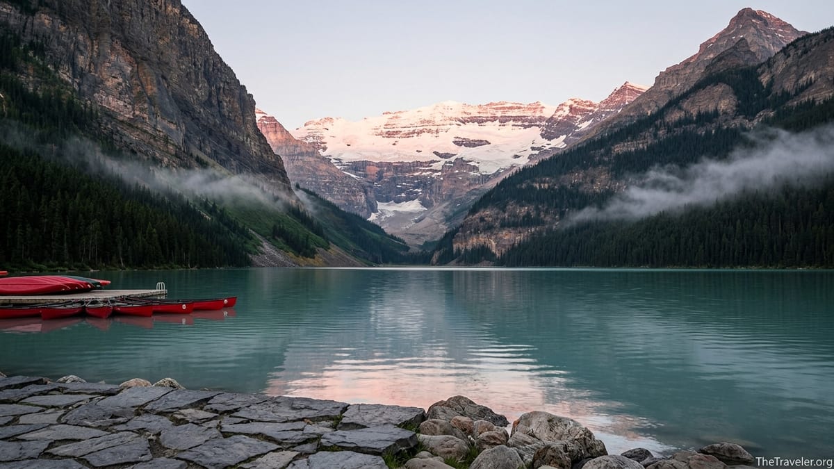
Stand on the crowded shoreline at Lake Louise on any August morning and you will hear the same reaction in a dozen languages: a sharp intake of breath, then a quiet "wow." Cameras all point in one direction, toward a precise composition of turquoise water framed by dark spruce, steep rock walls and, at the far end, a distant crown of ice. That ice is Victoria Glacier, and although many visitors do not know its name, this glacier has shaped almost every part of the scene they traveled so far to see.
Get the latest updates straight to your inbox!
The Glacier Most Visitors Never Really See
On paper, Lake Louise is just a small alpine lake in Banff National Park, about 2.4 kilometers long and less than a kilometer wide, sitting at roughly 1,730 meters above sea level. In reality it is one of the most photographed places in Canada, drawing so many people in peak season that Parks Canada now relies on shuttle buses and advance reservations to manage access. Yet for all the smartphones pointed at the horizon, few people on the crowded stone wall in front of the Fairmont Chateau Lake Louise could tell you the name of the glacier that fills the center of their frame.
From that lakeshore, Victoria Glacier can look almost like a painted backdrop, a white band nestled beneath Mount Victoria and flanked by Mount Lefroy. On a clear day in July, you might trace the broken seracs with your eyes but never quite register that this is not a static block of ice. It is a living, shifting glacier flowing down from snowfields above the Continental Divide toward the Plain of Six Glaciers and, ultimately, the lake itself. Guides at the Lake Louise Visitor Centre will often point out that the lake is a “glacial mirror,” reflecting the light of the ice that feeds it as much as the mountains around it.
Spend ten minutes watching people on the shore and you will see the disconnect. A family from Texas poses with red rental canoes bobbing in the foreground. A couple from Germany angles their tripod so the hotel disappears just out of frame. Hikers adjust boots and shoulder straps before setting off toward the tea houses. Few glance long enough at the far end of the valley to see the faint blue fracture lines that reveal where snow becomes ice, and ice becomes the meltwater that makes Lake Louise famous. The glacier is the subject of the view, but not yet the star of the story for most visitors.
That changes the first time you hike closer. As you leave the shoreline and follow the lakeshore trail, Victoria Glacier gradually shifts from distant decoration to imposing presence. By the time you reach the Plain of Six Glaciers viewpoint, the same ice that once looked like a thin streak has grown into a jagged world of crevasses, seracs and cliffs. Only then do most travelers realize just how much that glacier has done to shape the landscape they admired from afar.
How Victoria Glacier Sculpted the Iconic Lake Louise Valley
To understand why Victoria Glacier matters so much to Lake Louise, it helps to picture the valley without ice. Before the last ice age, this was a typical river valley in the Rockies. Over thousands of years, repeated advances of glacier ice flowed down from the high peaks, gradually carving the valley into the classic U-shape you see today. The steep walls below Mount Fairview and the Big Beehive are textbook examples of glacial erosion: their smooth upper slopes and cliffy lower faces were polished and plucked by moving ice, not by rivers.
Geologists who study the area point out that Victoria Glacier did more than simply gouge rock. As it ground its way down-valley, it acted like a conveyor belt for broken stone, carrying boulders and fine rock flour inside and beneath the ice. At its lower limit, the glacier dumped that debris to form a natural dam known as a terminal moraine. The turquoise waters of Lake Louise now sit snug against that moraine; without it, meltwater would simply drain away and the world-famous lake would be a small stream in a forested valley.
Even some of the best-known viewpoints around the lake are products of this glacial sculpting. The Big Beehive and Little Beehive, the rounded rock prominences above the north shore, were shaped as roches moutonnées, smoothed on the side where ice pushed up against them and steep on the lee side where blocks were plucked away. When you stand at the Lake Agnes Tea House or the Big Beehive lookout and look down at Lake Louise, you are standing on rock forms literally carved into shape by glacial movement from Victoria Glacier and its neighbors.
Modern visitors encounter these results as a series of attractions rather than pieces of one process. They book a sunrise canoe rental from the dock in front of the Chateau, hike to Lake Agnes for tea, or take a guided hike up the Plain of Six Glaciers trail. But under all of these experiences lies the same story: a glacier that bulldozed, polished, and rearranged the valley into the amphitheater that now frames every social media post from the lake.
The Secret Behind the Turquoise Water
Ask ten people on the Lake Louise shoreline why the water is so vividly turquoise and you will hear confident but often incomplete answers. Some will mention minerals, others will say “it’s just very clean,” and a few will shrug and admit they have no idea. The real explanation leads straight back to Victoria Glacier. The color comes from suspended rock flour, the ultra-fine particles created as the glacier scrapes bedrock beneath its mass. As the glacier melts in summer, streams carry this pale silt into the lake, where it remains suspended in the cold water.
Because these particles are so small, they scatter sunlight in a particular way, reflecting mainly the blue-green wavelengths back toward your eyes. On clear days around midday in July and August, when the sun is high, the effect can be startling. The surface of the lake glows a milky, opaque turquoise that looks almost unreal. When clouds roll in or autumn temperatures cool the meltwater supply, the color softens to a deeper blue-green. Regular visitors who return in late September often remark that “the lake looks darker,” not realizing that Victoria Glacier is delivering less fresh rock flour as the melt season winds down.
The intensity of the color also varies from year to year with snowfall and summer warmth. After winters with heavy snowpack, early summer melt can bring extra pulses of silt-rich water into the lake. Visitors arriving in late June may find the color nearing its peak several weeks earlier than friends who came in a cooler year. Local guides often plan photography workshops accordingly, timing small-group shoots to catch mornings when calm water and strong summer sun maximize that glacial hue.
You can see the glacier’s influence even during a short canoe rental. Paddle straight out from the boathouse for about fifteen minutes and stop. Look down into the water and you will notice that you cannot see far into its depths despite its clarity. The suspended rock flour gives the lake a milky opacity compared to non-glacial lakes in the region. What feels like simple color is, in reality, the signature of Victoria Glacier, painted across the water in every direction.
Getting Closer: Trails, Tea Houses, and Viewpoints of the Glacier
Most visitors experience Victoria Glacier from afar, but it is surprisingly accessible if you are prepared to walk. The Plain of Six Glaciers trail is the classic introduction. Starting from the lakeshore, this route follows the right-hand side of Lake Louise before climbing gradually into the upper valley. Within half an hour of leaving the throngs near the hotel, the crowds thin out, the sound of tour buses fades, and the glacier begins to dominate the view ahead.
After roughly 5 to 6 kilometers of hiking, many people reward themselves with a stop at the Plain of Six Glaciers Tea House, a rustic spot that serves simple lunches, cakes and hot drinks during the summer season. Sitting on the wooden deck with a mug of tea, you can look directly toward the broken icefalls of Victoria Glacier and hear the occasional roar of rockfall echoing off the cliffs. For many travelers, this is the first time the distant white patch from their lakeside photos resolves into a fractured landscape of seracs, debris and exposed ice.
Those with the energy to continue a little farther gain an even more dramatic vantage point. A side trail climbs beyond the tea house to a high viewpoint where the maintained path ends. Here you can look across the rubble-filled Plain of Six Glaciers and up to the vertical face of Mount Victoria, with the glacier spilling down in frozen waves. In late summer, the ice can appear streaked with dust and rock, a visible reminder that glaciers are conveyors of debris as much as they are reservoirs of snow.
Other hikes offer complementary perspectives. The Fairview Mountain trail, starting near the canoe docks, climbs steeply to a summit above the lake that provides a side-on view of Victoria Glacier and its cirque. Meanwhile, the Highline trail that links the Plain of Six Glaciers with Lake Agnes gives hikers oblique angles down toward the glacier and the lake simultaneously. On a clear day in September, you might stand there watching fresh snow powder the upper glacier while larches turn gold on the lower slopes, experiencing the full vertical range of the valley in a single sweep of the eyes.
Victoria Glacier in a Warming World
As awe-inspiring as Victoria Glacier appears from the Plain of Six Glaciers viewpoint, it is smaller than it was a century ago, and smaller still than in the 19th century when railway surveyors first promoted Lake Louise as a tourist destination. Historical photographs from Parks Canada archives and local museums show the glacier filling more of the upper valley and extending farther down toward the plain. Today, bare rock and loose debris occupy spaces that were once solid ice.
Scientists who monitor glaciers in the Canadian Rockies point to a consistent trend of retreat and thinning over the past several decades. Warmer average temperatures, along with longer melt seasons, have reduced the mass of many valley glaciers, including Victoria. While exact rates vary from year to year, visitors familiar with the area often notice exposed cliff bands and dark lateral moraines where continuous ice previously covered the rock. On hot summer afternoons, the steady drip and trickle of meltwater below the glacier is a subtle soundtrack to this change.
For travelers, this context adds a bittersweet note to the view. When you photograph Lake Louise with Victoria Glacier in the background, you are also documenting a moment in the glacier’s life. Families who return after twenty or thirty years sometimes compare old prints with new images and notice that the ice appears slightly farther from the plain or more broken up at the margins. Guides increasingly weave this story into their commentary, explaining how the glacier’s retreat influences late-season lake levels, water temperatures, and the timing of the turquoise color each year.
Despite this retreat, Victoria Glacier remains a powerful presence, and for now it continues to dominate the visual identity of Lake Louise. Understanding its vulnerability can change the way you move through the landscape. Many travelers now build learning experiences into their visit, joining guided hikes that discuss glaciology, or stopping at interpretive panels near the Lake Louise Visitor Centre that compare current photos with early 20th-century images. The more you know about the glacier’s changing shape, the more poignant every clear view of it becomes.
Planning Your Visit With the Glacier in Mind
Seeing Victoria Glacier at its best requires a bit of timing and logistics, especially as visitation to Lake Louise continues to grow. In summer, private parking at the lake often fills early in the morning, and Parks Canada encourages visitors to reserve shuttle buses from the Lake Louise Ski Resort park-and-ride lot. If you plan to photograph the glacier from the lakeshore, aim to arrive as early as possible, ideally before 8 am, when the water is often calm and the light is soft on the peaks. By midday, reflections can be washed out and crowds gather along every stretch of shoreline.
For those who want a closer encounter, consider building a full hiking day around the glacier. A common plan is to start from the lakeshore, hike up to the Plain of Six Glaciers Tea House in the late morning, then continue toward the upper viewpoint before returning via the Highline trail to Lake Agnes and down the forested switchbacks to the lake. This creates a varied loop that shows the glacier from multiple angles while spreading your time away from the busiest areas. Fit, acclimatized hikers often describe this as a rewarding but full day outing, best tackled with an early start, sturdy footwear and layered clothing ready for rapid weather changes.
Winter introduces a different relationship with the glacier. From roughly November to April, the lake typically freezes and is covered in snow, and the main access is via an often-packed winter trail from the parking area. Cross-country skiers and snowshoers traverse the lake surface toward the valley’s end, their tracks pointing like an arrow to the glacier high above. Avalanche risk increases dramatically beyond the forested sections and into the upper valley, so most independent visitors limit their winter adventures to the lake surface and nearby forest trails. Guided winter programs with experienced local operators can offer safer ways to learn about the glacier’s cold-season dynamics.
Whenever you visit, small choices can sharpen your awareness of Victoria Glacier. Take a moment at the lakeshore to trace the line from the bright lake surface back to the distant ice, imagining the invisible streams that link the two. Carry an old postcard or a downloaded historical image on your phone and compare it to the scene in front of you. Ask rangers at the visitor centre where to find up-to-date interpretive displays about the glacier’s history. Such simple steps can turn a quick viewpoint stop into a deeper conversation with the landscape.
Photography Tips: Making the Glacier the Star of Your Shot
For many visitors, their most lasting connection to Victoria Glacier will be through photographs. Yet in countless images shared online, the glacier appears only as a thin white line above the lake, overshadowed by the turquoise foreground. With a few intentional choices, you can compose shots that highlight the glacier’s role without sacrificing the beauty of the wider scene.
From the main lakeshore wall in front of the Chateau, try using a slightly longer focal length instead of an ultra-wide lens. A zoom in the 50 to 70 millimeter range on a full-frame camera, or its equivalent on a phone’s telephoto setting, compresses the scene enough to enlarge Victoria Glacier in the frame while still including a band of water for context. Early morning and late afternoon light create shadows on the glacier’s face that reveal its crevasses, making the ice look more three-dimensional than it does under the harsh midday sun.
If you are willing to walk, some of the most effective glacier-focused compositions come from along the lakeshore or partway up the Plain of Six Glaciers trail. From the far end of Lake Louise, near where the boardwalk meets the delta, you can frame the glacier directly between the valley walls, with braided streams in the foreground leading the eye toward the ice. On hazy days when distant details are muted, stepping closer along the trail allows the glacier’s fractured surface to show through the atmospheric veil.
Do not overlook the power of vantage points above the lake. From the Big Beehive lookout, the glacier appears smaller but still central, floating above the turquoise water like a crown. Here, a wider lens or phone camera excels, capturing the sweeping S-curve of the lake with the white band of Victoria Glacier anchoring the horizon. Including elements such as weathered rock in the foreground or a small human figure on the trail can emphasize the scale of both the valley and the ice that shaped it.
The Takeaway
Lake Louise’s beauty is often described in terms of color and symmetry: the perfect balance of turquoise water, dark forest, gray rock and white peaks. Yet behind that visual harmony stands a single, tireless sculptor. Victoria Glacier carved the valley’s U-shaped profile, built the moraine that holds the lake in place, ground the rock flour that colors the water and continues to feed the lake with meltwater each summer. Without it, the famous view would be unrecognizable.
For travelers, recognizing Victoria Glacier’s role changes the experience of Lake Louise from passive admiration to active understanding. The glacier becomes more than a backdrop; it becomes a protagonist, with a history, a present and an uncertain future in a warming climate. Whether you view it from the hotel terrace, a rented canoe, the deck of the Plain of Six Glaciers Tea House or a windy summit thousands of meters above the lake, you are witnessing one chapter in a much longer story written in ice and rock.
The next time you find yourself on that crowded shoreline, take a moment before raising your camera. Trace the journey of a drop of water from high on the glacier down invisible melt channels, into silt-laden streams, across the delta and out into the turquoise lake at your feet. In that brief exercise of imagination, the famous Lake Louise view rearranges itself. The glacier at the far end of the valley is no longer just part of the scenery; it is the quiet architect of everything you see.
FAQ
Q1. What exactly is Victoria Glacier?
Victoria Glacier is a valley glacier above the western end of Lake Louise, flowing down from the high peaks around Mount Victoria and supplying meltwater and rock flour that shape the lake’s color and landscape.
Q2. Why is the water at Lake Louise so turquoise?
The striking turquoise color comes from very fine rock particles, or rock flour, carried into the lake by meltwater from Victoria Glacier; these particles scatter sunlight and reflect mainly blue-green wavelengths.
Q3. Can I hike right up to Victoria Glacier?
You cannot safely walk onto the glacier without technical skills and proper guiding, but the Plain of Six Glaciers trail takes you to excellent viewpoints quite close to its lower icefalls.
Q4. What is the best season to see Victoria Glacier?
From late June through September, snow has mostly melted from the lower slopes, trails are usually clear, and the glacier stands out sharply above the turquoise lake under long summer daylight.
Q5. Is Victoria Glacier shrinking because of climate change?
Like many glaciers in the Canadian Rockies, Victoria Glacier has been gradually retreating and thinning over the past century, a trend scientists link to warming temperatures and longer melt seasons.
Q6. Where is the best place to photograph Victoria Glacier?
Classic views come from the main lakeshore in front of the Chateau, the far end of Lake Louise near the delta, and higher up on the Plain of Six Glaciers and Big Beehive trails.
Q7. Do I need special equipment to hike to the glacier viewpoints?
In summer, sturdy walking shoes, layered clothing, water and snacks are usually sufficient for most fit visitors on maintained trails, though trekking poles and light rain gear can make the outing more comfortable.
Q8. Can I see Victoria Glacier in winter?
Yes, the glacier remains visible high above the frozen lake in winter, but access beyond the lakeshore and nearby forest trails involves avalanche terrain and should only be attempted with proper training or a qualified guide.
Q9. How long does it take to hike the Plain of Six Glaciers trail?
Most visitors allow four to six hours for a return hike from Lake Louise to the tea house and viewpoint, depending on pace, photo stops and weather conditions.
Q10. Are there guided tours that explain the glacier’s history?
Several local operators and Parks Canada programs offer guided walks and hikes around Lake Louise where guides discuss Victoria Glacier’s formation, retreat and influence on the lake and valley.