
More news on this day
A powerful magnitude 7.8 earthquake struck off the southern Philippine island of Mindanao on June 8, coinciding with the first day of the new school year and sending students and teachers fleeing from classrooms and flag ceremonies across the region.
Get the latest news straight to your inbox!
Strong quake hits during opening-day flag ceremonies
According to publicly available seismic data, the offshore earthquake was recorded early Monday morning local time off the coast of Sarangani province at a depth of around 30 to 35 kilometers. Shaking was felt across wide areas of Mindanao, including General Santos City, Davao Region and parts of the Soccsksargen and Caraga regions.
Published coverage indicates that many public schools had just begun first-day flag ceremonies when the ground began to move, forcing children and staff to rush out of courtyards and assembly areas. In Maasim, Sarangani, local reports describe students screaming and dropping to the ground as the shaking intensified.
Preliminary tallies from national and local disaster offices, cited in multiple news reports, indicate that at least several dozen people were killed and hundreds injured in the earthquake and its immediate aftermath. The death toll remained fluid on June 9 as search and rescue operations continued in collapsed buildings and landslide zones.
The quake also generated tsunami waves reported at about one meter high along parts of the southern coast. Public bulletins show that coastal communities in Sarangani and nearby areas were ordered to move to higher ground as a precaution, with smaller waves registered in neighboring countries around the western Pacific.
Schools damaged and classes suspended across Mindanao
Education officials in Mindanao reported widespread disruption to the long-planned reopening of in-person classes. Publicly available information from the Philippine Department of Education shows that millions of students were scheduled to return on June 8 after the school break, with many campuses hosting welcome programs and orientation activities when the quake struck.
News footage and images shared by local media show collapsed or heavily damaged school buildings in several provinces, including Davao del Sur, Sarangani and Davao Occidental. Portions of older classroom blocks and covered courts appeared to have given way, scattering debris across school grounds and leaving some campuses unusable pending structural assessments.
As initial damage reports filtered in, authorities announced the suspension of classes across large parts of Mindanao for at least one day to allow engineers to inspect facilities. Published statements from national leaders emphasized that in-person learning would only resume in affected areas once school buildings had been cleared as structurally safe.
In communities closest to the epicenter, teachers and local officials shifted quickly from first-day activities to emergency response, helping move children away from walls and power lines and guiding them toward open fields and evacuation areas. Social media posts from parents describe chaotic scenes as families rushed to pick up their children amid lingering aftershocks.
Urban damage in General Santos and surrounding provinces
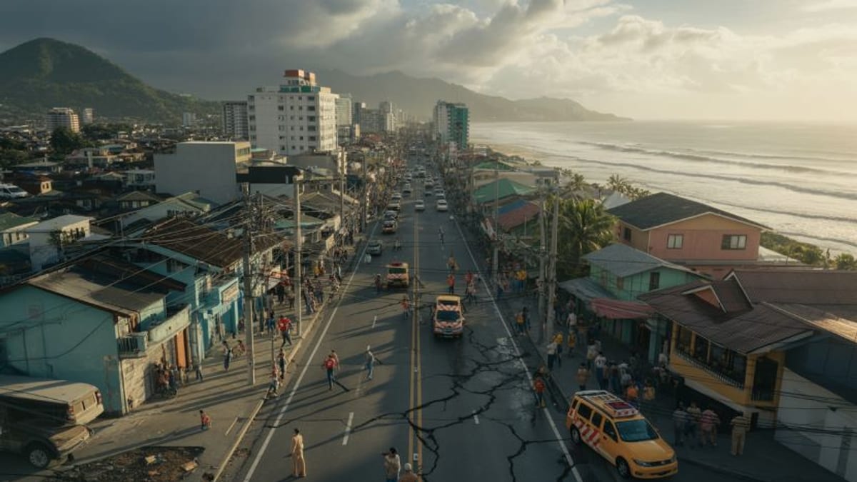
The regional hub of General Santos City, a fishing and commercial center at the southern tip of Mindanao, sustained some of the most visible structural damage. Photographs carried by international and Philippine news outlets show multiple low and mid-rise buildings with collapsed facades, buckled columns and shattered windows.
Reports indicate that several commercial structures and residential buildings partially gave way, trapping occupants and pedestrians. Emergency responders used heavy equipment and improvised tools to clear debris and search for survivors, while residents were advised to stay clear of damaged structures and downed power lines.
In Sarangani, South Cotabato and Davao Occidental, landslides were reported along mountain roads and near lakes, complicating access to isolated communities. Images from affected provinces show sections of hillside that had slipped onto highways, as well as cracks on bridges and coastal infrastructure.
Power interruptions were widespread across southern Mindanao immediately after the quake. Public utility updates suggest that electricity and telecommunications were gradually being restored through Monday night and Tuesday in key urban areas, though some remote municipalities remained without full service.
Tsunami alerts and travel disruption across the region
The offshore epicenter prompted regional tsunami bulletins from international monitoring centers, which warned of possible hazardous waves along parts of the Philippine coastline and elsewhere in the western Pacific. According to publicly available advisories, authorities ordered evacuations from low-lying coastal areas, particularly in Sarangani Bay and nearby shorelines.
While the tsunami waves that reached the southern Philippines were relatively small compared with those generated by the strongest subduction earthquakes, local media reports document localized flooding in ports and fishing villages. At least one port in the Balut Islands reportedly suffered quay and cargo-yard damage when water surged inland, scattering small boats and equipment.
The earthquake and tsunami warnings disrupted sea travel and some domestic flights serving Mindanao’s southern gateway cities. Ferry operators temporarily halted sailings from several ports while crew inspected vessels and harbor facilities, and airlines reported delays on routes into General Santos and Davao as runways and terminal buildings underwent safety checks.
Travel advisories from risk consultancies and international missions recommended that visitors confirm the status of airports, seaports and overland routes before proceeding to affected areas. Tour operators in popular destinations across Mindanao were assessing possible impacts on coastal resorts and dive spots, even in areas that escaped direct damage but experienced strong shaking.
High-risk archipelago confronts another major seismic event
The Philippines lies along the Pacific Ring of Fire, where several tectonic plates meet and generate frequent earthquakes and volcanic activity. Government hazard maps classify much of Mindanao as high risk for strong ground shaking, with active offshore trenches and inland fault systems capable of producing large events such as the June 8 quake.
Recent years have seen a series of powerful earthquakes across the archipelago, including destructive events in Mindanao and Luzon that damaged schools, hospitals and heritage structures. Experts cited in news analyses note that the latest disaster adds urgency to ongoing efforts to retrofit vulnerable buildings and enforce seismic provisions in the national building code.
Preliminary assessments described in international coverage suggest that some of the worst damage during Monday’s quake occurred in older or previously compromised structures, including school buildings slated for rehabilitation. Newer facilities that met updated standards appeared to have performed better, although detailed engineering evaluations were still underway as of June 9.
As aftershocks continued to rattle southern Mindanao, humanitarian agencies began rapid assessments to identify urgent needs in affected communities, from emergency shelter and medical care to psychosocial support for children whose first day back at school turned into a frightening lesson in the country’s seismic reality.