
Pallas–Yllästunturi National Park in Finnish Lapland is often described by locals as the classic fell hiking destination of Finland. With its broad network of marked summer and winter trails, three main visitor centres and easy access from nearby ski villages, it is also one of the most practical wilderness areas to explore. This guide focuses on how to find reliable trail maps, understand the main routes, and plan a safe, enjoyable visit using concrete, real-world examples.
Get the latest updates straight to your inbox!
Understanding the Layout of Pallas–Yllästunturi
Pallas–Yllästunturi National Park stretches across roughly 130 kilometres of fells and forest between the municipalities of Kolari, Kittilä, Muonio and Enontekiö in Finnish Lapland. In practice, most visitors experience the park in three main sections that align with the visitor centres: the southern Ylläs and Äkäslompolo area, the central Pallas fells around Pallastunturi, and the northern area near Hetta. Knowing which section you want to focus on will help you choose the right trail maps and transport connections.
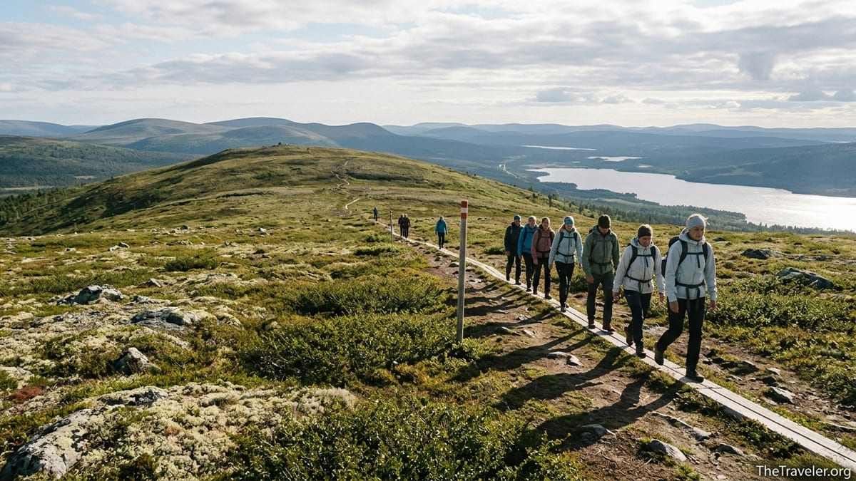
The park is renowned for its chain of fells such as Yllästunturi, Pallastunturi and Ounastunturi, with rounded summits that typically rise 400 to 700 metres above sea level. The highest point, Taivaskero in the Pallas group, reaches just over 800 metres, which makes the climbs significant but achievable for reasonably fit hikers in summer. In winter, the same terrain becomes a network of groomed ski trails and snowshoe routes, many starting right from the edge of resort villages like Äkäslompolo and Ylläsjärvi.
Because the park runs along a north–south axis with different gateway villages, you can treat it either as a base-camp destination for day hikes or as a multi-day trekking corridor. A common approach is to spend three or four nights in Äkäslompolo for shorter day hikes, then move by car or bus to Pallas or Hetta for a two- or three-day hut-to-hut trek. Trail maps, route markings and services are all organised with this structure in mind.
For first-time visitors, a practical mental map is: Ylläs area for easy access, family-friendly loops and resort services; Pallas for classic fell ridge day hikes; and the Hetta–Pallas route for a longer, more remote experience with wilderness huts and fewer crowds.
Where to Get Reliable Trail Maps
The most important digital mapping resource for Pallas–Yllästunturi is Finland’s official outdoor map service operated by Metsähallitus, the state forestry agency. The national park’s trekking routes, campfire sites, open wilderness huts, lean-tos and rental huts are all shown there on a zoomable topographic base. You can switch between summer trails and winter routes such as ski tracks and snowmobile corridors and print your own custom map section before you travel. Many local guides and cabin owners use this same official map as their planning reference.
On the ground, detailed paper maps are widely available in Lapland. In Äkäslompolo, for example, outdoor shops in the village centre sell waterproof 1:50 000 or 1:25 000 maps covering the Ylläs fells and the southern part of the park, typically priced around 10 to 15 euros. At Pallas, you can buy regional topographic sheets that include the classic Taivaskero and Pallas ridge routes. In Hetta, the visitor centre and local supermarkets often stock maps showing the full Hetta–Pallas trekking corridor and connecting routes toward Ounasjärvi lake and Ounastunturi.
If you prefer to navigate with your phone, several mainstream outdoor navigation apps include the Pallas–Yllästunturi trail network. Hikers commonly download GPX tracks of popular circuits like the Taivaskeron kierros day loop or the Hetta–Pallas route and import them into apps that work offline. A realistic example is a visitor flying into Kittilä, stopping at a supermarket in Levi to buy snacks, then downloading offline maps over Wi‑Fi before driving on to Äkäslompolo where mobile coverage becomes more patchy on certain trails.
Despite the quality of digital maps, carrying at least a small printed map section is advisable once you move away from the main fell villages. Weather in Lapland changes quickly; fog, wet snow or freezing rain can make phone screens difficult to use, and winter cold drains batteries faster than many travellers expect. A folded A4 printout from the official map service, stashed in a zip‑lock bag, is a simple but effective backup.
Visitor Centres and On-the-Ground Information
Pallas–Yllästunturi has three key visitor centres that act as trailheads, information hubs and exhibition spaces. In the south, Yllästunturi Visitor Centre Kellokas near Äkäslompolo offers detailed advice on day routes, current trail conditions and seasonal restrictions. Travellers report being able to walk in without a booking and, within 10 minutes, leave with a suggested itinerary tailored to their fitness, plus a paper map annotated by staff showing recommended rest spots and viewpoints.
In the central section, the Pallastunturi Visitor Centre sits close to the Pallas Hotel and the main road. It is a starting point for classic hikes such as the Pallas–Taivaskero ridge route, and in winter, for cross‑country ski loops over the fells and through old-growth spruce forests. During the main hiking and ski seasons, staff usually update whiteboards or printed notices with information on snow conditions, avalanche risk on steep fell flanks and any temporary closures near nesting sites or restoration areas.
In the north, Fell Lapland Visitor Centre in Hetta is the main gateway for the celebrated Hetta–Pallas trekking route. Hikers often stop here to buy a map, confirm boat transport across Ounasjärvi lake to the trailhead, and check if wilderness huts along the route are particularly busy. On a July weekend, for example, staff might realistically advise that the first hut is likely to be crowded by late evening and suggest carrying a lightweight tent to have more flexibility.
Across all three centres, you can typically find up-to-date printed trail brochures in English and Finnish, showing short, colour-coded routes that match the waymarking out on the terrain. These brochures are especially useful if you are planning family outings or short walks of 3 to 8 kilometres and want quick, simple map sketches without delving into full topographic sheets.
Key Trails and How to Read Their Maps
The park’s most famous multi-day route is the roughly 50 to 60 kilometre Hetta–Pallas trek, depending on the exact line you follow. Maps show a well-marked summer trail running along the fell chain between the two villages, with open wilderness huts spaced at intervals that make 3- to 6‑hour walking days realistic for moderately fit hikers. In winter, ski routes broadly parallel this line but sometimes divert into safer, lower-angled terrain; winter maps, whether printed or in digital app layers, always distinguish these ski tracks from summer footpaths.
Around Pallas, day hikers often start from the Pallastunturi Visitor Centre or the nearby hotel parking area. Maps highlight the Taivaskeron kierros circle route, which climbs to the high ridge and returns via a different line, giving varied views across the fell chain and over Pallasjärvi lake. On a typical August day, a visitor might take 4 to 5 hours to complete this loop at a relaxed pace, including photo stops and a lunch break behind a boulder out of the wind. Map contours help you gauge where the steeper sections are and where the plateau sections allow for easier walking.
In the Ylläs area, trail maps around Äkäslompolo and Ylläsjärvi show a dense network of forest paths and boardwalks, plus several routes to the top of Yllästunturi. For example, the Varkaankurun polku trail is a popular short route through a rocky gorge, while the longer Kesänkijärven kierros circle trail takes in scenic lake views and a moderate ascent. On printed and digital maps, these routes are usually colour-coded, with legend boxes explaining the symbols for campfire sites, lean-tos and viewpoints, which makes it easier for new visitors to choose routes suitable for half-day wanders versus full‑day hikes.
Winter trail maps layer in additional complexity with groomed cross‑country ski tracks, snowshoe routes and snowmobile corridors. A practical example is a February visitor staying in Äkäslompolo who uses a resort‑issued winter map: blue lines indicate easier ski loops through forest, red or black lines show more demanding routes over open fells, and dotted lines may mark recommended snowshoe itineraries. Understanding these symbols is crucial for staying on appropriate terrain given your skill level and the daylight available.
Planning Your Visit: Access, Seasons and Timing
Reaching Pallas–Yllästunturi typically involves a combination of flight or night train plus regional bus, or a rental car for maximum flexibility. Many international visitors fly to Helsinki and then onward to either Kittilä or Rovaniemi airports. From Kittilä, pre‑booked shuttle taxis and seasonal buses connect to villages like Äkäslompolo, Ylläsjärvi and Pallas. From Rovaniemi, long‑distance buses run north toward Kittilä, Muonio and Hetta, stopping at road junctions close to the park and, in high season, sometimes directly at visitor centres or resort areas.
Another well-used option is the night train from Helsinki to Kolari, which allows you to sleep in a cabin while your car, if you bring one, travels on the same train. From Kolari, it is roughly an hour’s drive to Äkäslompolo and a bit more to Pallas. Some travellers who want to minimise driving choose to rent a car in Kolari or Rovaniemi rather than Helsinki to avoid a full day on the road and to be closer to local conditions when they first drive in Lapland.
Seasonal timing has a major effect on which trail maps you will actually use. From late June through early September, summer hiking routes are generally snow-free, and printed summer maps or the summer layer on digital services are the main references. In October, conditions become more mixed, with early snow and icy boardwalks, so many visitor centres advise sticking to lower forest trails that are clearly marked and well trodden. From around November through April, winter maps and ski trail charts become essential, with routes groomed for classic and skate skiing, and certain higher ridges only recommended with proper winter gear and experience.
A practical example of timing is a family trip in early August: staying four nights in Äkäslompolo, using a summer trail brochure from Kellokas for half-day loops, then driving two hours north to Hetta, where they collect a separate map focused on the Hetta–Pallas trek and spend three days walking between wilderness huts. The family would be working with at least two different map products for the same park, each chosen to match the terrain and length of their planned routes.
Accommodation, Services and Safety on the Trails
Maps of Pallas–Yllästunturi do not just show trails; they also mark wilderness huts, campfire places, lean-tos, rental cabins and in some cases commercial accommodation just outside the park boundary. In the Ylläs area, visitors often stay in self-catering log cabins or apartment-style units in Äkäslompolo or Ylläsjärvi, then walk or ski directly from the door onto marked routes. In Pallas, a traditional hotel and nearby cabins sit almost at the treeline, so a 10-minute walk can have you onto a ridge path with extensive views.
On the longer Hetta–Pallas trek, open wilderness huts and reservable huts are spaced at intervals that allow for flexible itinerary planning. A typical three-night route might involve one night in an open hut, one night in a reservable hut booked in advance through the official system, and one night in a tent near a designated campfire place. Trail maps make clear which huts are open to everyone free of charge and which require prior reservation and a fee. This clarity helps avoid the common beginner mistake of assuming that all huts are first-come, first-served.
Safety planning should always sit alongside map reading. The park is generally considered safe and well managed, but conditions can change quickly, especially above the treeline. On a blustery September day, clouds can drop over the fells and reduce visibility to tens of metres, even when the forest lower down remains relatively clear. Having both a digital GPX track and a paper map, plus knowing how to orient yourself using the clear fell ridge lines, reduces the risk of navigation errors in such conditions.
Realistic, practical preparation includes packing enough layers to cope with temperatures that can fall close to freezing even in midsummer nights, carrying at least a simple power bank to keep your phone alive for navigation, and checking in with visitor centre staff about any recent incidents such as washed‑out bridges or bear sightings near berry patches. Maps may not reflect changes that occurred after they were printed, so combining them with fresh local advice is good practice.
Using Maps Responsibly: Nature Protection and Local Etiquette
Pallas–Yllästunturi is valued for its relatively intact fell ecosystems, and responsible map use means more than just not getting lost. Trail maps distinguish between marked official routes and informal paths created by repeated foot traffic. Staying on marked routes, particularly in wet mires and fragile fell heath, helps prevent erosion and protects slow-growing vegetation such as ground lichen, which reindeer depend on in winter. In practice, this might mean resisting the temptation to cut switchbacks or create your own shortcut on a steep section, even when your GPS device suggests a more direct line.
Maps also mark zones where specific rules apply, such as campfire restrictions or areas where dogs must be kept on a leash. In dry, windy periods, local authorities often impose temporary bans on open fires, and these are typically posted at trailheads and visitor centres. Even if your printed map shows designated campfire sites, it is essential to check whether current conditions allow their use and to be prepared to cook on a camping stove instead.
Respecting local culture is another subtle aspect of using maps well. The park lies in traditional Sámi areas, and reindeer herding is an ongoing livelihood. Trails sometimes cross reindeer fences or pass near herding structures, which may be indicated on detailed maps or simply encountered on the ground. The responsible approach is to use gates rather than climbing fences, to keep dogs under control around reindeer, and to avoid lingering too close to active herding operations even if your map shows an appealing open area nearby.
Finally, when sharing your own GPX tracks or map screenshots online after the trip, consider whether you are encouraging others to venture into very sensitive areas or off-trail zones that lack infrastructure. Highlighting official routes and established rest spots supports the park’s management goals and keeps visitor impact concentrated where it can be best handled.
The Takeaway
Pallas–Yllästunturi National Park combines wild fell landscapes with some of the best-maintained trail infrastructure in Finland. With official digital maps, detailed paper sheets and practical brochures from visitor centres, you have a robust set of tools for planning anything from gentle family walks to multi-day ridge treks. The key is to match your maps to the season, section of the park and style of trip you have in mind, rather than relying on a single generic overview.
For most travellers, a realistic strategy is to start with the official online map before the trip, buy a waterproof regional map on arrival in Lapland, and refine plans in conversation with staff at Kellokas, Pallastunturi or Hetta visitor centres. Combined with weather awareness, basic safety preparation and respect for nature and local culture, this approach will help you navigate the park with confidence and enjoy the long views, quiet forests and high ridges that make Pallas–Yllästunturi such a special corner of Finnish Lapland.
FAQ
Q1. Do I really need a paper map in Pallas–Yllästunturi if I use a phone app?
While many hikers navigate primarily with phone apps, carrying at least a small printed map is strongly recommended. Cold temperatures, battery drain and sudden fog can make digital navigation unreliable, and a basic paper map gives you a backup that does not depend on electronics.
Q2. Which visitor centre is best for first-time visitors to the park?
For first-time visitors, Yllästunturi Visitor Centre Kellokas near Äkäslompolo is often the easiest starting point. It has clear information in English, simple brochures with short, well-marked trails and quick access to both forest paths and fell views, making it ideal if you are still getting used to Lapland conditions.
Q3. What is the best season for using the hiking trail maps rather than ski maps?
Summer hiking maps are most useful from late June to early September, when snow has largely melted from the fells and wooden duckboards are not icy. Outside this period, especially from November to April, winter-specific maps that show ski and snowshoe routes become more relevant.
Q4. Is the Hetta–Pallas trail suitable for beginners?
The Hetta–Pallas route is achievable for fit beginners who are comfortable walking several hours per day with a backpack and who prepare properly. It is a remote fell trek with limited services, so first-timers should carry appropriate clothing, navigation tools and food, and consider planning slightly shorter days than experienced trekkers.
Q5. Can I rely on trail signs alone without studying a map?
Trail signs in Pallas–Yllästunturi are generally clear, but relying solely on them is not recommended. Signs can be covered by snow, damaged by weather or missed in poor visibility. Studying a map beforehand helps you understand the general direction, distances and elevation changes, so you can recognise if something does not match expectations.
Q6. How do I find current information on closed trails or restrictions?
The most reliable way is to check notices at the visitor centres and major trailheads and to ask staff directly. They receive up-to-date information on maintenance work, fire bans, wildlife-related closures and seasonal restrictions that may not yet be reflected in printed maps.
Q7. Are GPX tracks from other hikers safe to follow?
Shared GPX tracks can be a helpful reference, but they should not replace official maps and local advice. Tracks from other hikers may cross sensitive areas, use seasonal ice crossings or take shortcuts that are not recommended. Always compare any GPX route with an official map and adjust it if necessary.
Q8. Is public transport sufficient, or do I need a rental car to use the trails?
Public transport can get you to key gateways like Äkäslompolo, Pallas and Hetta, especially during the main seasons, and many visitors hike entirely by bus and train. However, a rental car gives more flexibility to combine different sections of the park in one trip and to start early or finish late without being tied to bus timetables.
Q9. What scale of map is best for day hikes?
For day hikes, a 1:25 000 or 1:50 000 topographic map works well. The larger-scale 1:25 000 maps show more terrain detail, which is helpful in complex fell areas, while 1:50 000 maps give a broader overview that is sufficient for most marked routes and easier to carry as a single sheet.
Q10. Are there easy trails suitable for families with children?
Yes, there are several family-friendly trails near Äkäslompolo, Ylläsjärvi, Pallas and Hetta. Visitor centre brochures and local maps highlight shorter loops of 3 to 6 kilometres with gentle elevation, rest spots and campfire places, which are realistic outings for families with school-age children.