
From a distance on Utah Highway 261, the Bears Ears look almost modest: two rounded buttes rising above the long, flat line of Cedar Mesa. It is only when you leave the pavement, bump along the dirt roads, and finally stand beneath those twin sandstone towers that their true scale, history, and spiritual weight come into focus. What I expected to be just another pretty desert overlook turned into one of the most humbling experiences I have had on public land in the American West.
Get the latest updates straight to your inbox!
Finding the Twin Buttes in a Vast, Untamed Monument
Bears Ears National Monument covers about 1.35 million acres in southeast Utah’s San Juan County, an expanse of canyons, mesas, and pinyon-juniper forest that can feel more like a region than a single destination. There is no official national monument visitor center waiting with a gift shop and clear directions. Instead, access is scattered along highways 191, 95, 261, and 163, with small gateway towns like Bluff, Blanding, and Monticello serving as launchpads. The twin buttes that give the monument its name rise north of Cedar Mesa, poking above the forest like two stone sentinels.
Most travelers first glimpse the buttes from the south, climbing the serpentine switchbacks of Highway 261 after leaving the San Juan River country near Mexican Hat. Local maps mark the buttes simply as “Bears Ears,” their summits around 8,700 to 9,000 feet in elevation, roughly 2,000 feet higher than the surrounding mesa. From the highway they are an intriguing landmark on the skyline; the challenge is figuring out how to get close enough that they fill your entire field of view.
The practical gateway for many visitors is Bluff, about a 45-minute drive from the Cedar Mesa region. In this small town on the San Juan River, the community-run Bears Ears Education Center helps people understand how to travel respectfully in the monument and offers current information on road conditions, fire restrictions, and cultural site etiquette. Starting here, rather than driving directly to a trailhead, gives essential context before you ever see the ears up close.
From Bluff or Blanding, the approach to the buttes often involves a combination of paved highway and graded dirt roads that climb onto Cedar Mesa. Services disappear quickly: no gas stations, no restaurants, and very little cell service once you leave the main highways. It is the kind of place where you fill your tank in town, load several gallons of drinking water into the car, and double-check that your spare tire is ready before heading toward that distinctive skyline.
The Road to the Ears: A Journey Into Scale
Reaching the base of the twin buttes is less about a single trail and more about navigating a small network of forest roads on the upper reaches of Cedar Mesa. State Route 95 intersects with Highway 261 at the mesa’s northern edge; from this junction, a series of dirt and gravel roads maintained by the Bureau of Land Management and the Manti–La Sal National Forest lead toward the buttes. In dry weather, a high-clearance vehicle is strongly recommended, though a cautious driver in a regular SUV can often make it when the roads are graded and firm.
Even with good directions from the Bears Ears Education Center in Bluff or the Kane Gulch Ranger Station on Highway 261, distances can be deceptive. A road that looks like a short spur on the map might take 30 to 40 minutes to drive. In early summer, when afternoon thunderstorms can turn sections of track into slick red mud, that time can double. When I visited in late May, the last 20 minutes of the approach were a slow crawl over washboard, shallow ruts, and patches of lingering snowmelt mud in the shade of the pines.
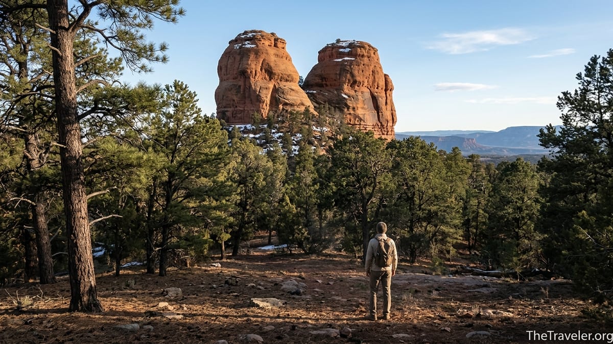
What surprised me most on the drive was how long the buttes stayed at eye level. They seemed to hover on the horizon, never getting closer, until the road finally curved and climbed into their shadow. There was no grand entrance sign, just a rough pullout in the forest with a view that suddenly snapped everything into scale: two towers of Wingate Sandstone shouldering straight up from the trees, their rounded tops dusted in late-season snow, their flanks streaked with dark desert varnish.
Standing at that pullout, I realized that the “ears” are not small knobs but substantial peaks rising steeply from the mesa. Even from roughly a mile away, the rock walls were tall enough to dwarf the surrounding pines. It felt less like approaching a butte and more like standing at the base of a compact mountain range, one that just happens to be made of rust-red stone instead of granite.
What It Feels Like to Stand Beneath the Twin Buttes
The moment I stepped out of the car near the base of the Bears Ears, the quiet was striking. This was not the hushed murmur of a popular national park overlook. There were no tour buses idling, no ranger talks carrying across the parking lot. The only sounds were the wind in the pinyon, the occasional chatter of a jay, and the faint thud of my boots on the needle-strewn forest floor.
Up close, the twin buttes feel alive with texture. The sandstone is cross-bedded and visibly layered, each line a record of ancient deserts and vanished rivers. Vertical cracks divide the rock into columns, and in the early morning light the faces are a patchwork of orange, rust, and purple-grey. Snowmelt trickled from shaded ledges into small seeps at the base, supporting pockets of grasses and wildflowers that seemed out of place in such a harsh landscape.
What impressed me most was the way the buttes play with perspective. From the highway, they look like modest, rounded ears. Standing underneath, with your back against the forest and your face tilted straight up, they feel impossibly tall. The tops are not visible from the base; instead, the walls rise out of sight, forcing you to imagine their rounded summits. I found myself circling around the trunks of ponderosa pines to catch different angles, marveling at how the ears shifted from blunt domes to sharp silhouettes depending on where I stood.
This sense of scale has a way of shrinking your own concerns. Modern debates over monument boundaries and political proclamations feel very small when you are standing in the shadow of rock that has towered over this mesa for millions of years. It is not a dramatic, crowded vista like the rim of the Grand Canyon; it is a quieter, more intimate awe, the kind that settles in as you listen to the wind whistling along the cliff faces.
A Living Cultural Landscape, Not Just a Scenic Backdrop
Long before Bears Ears became a national monument in 2016 and a flashpoint in national debates over public lands, these buttes were, and remain, a sacred place for Indigenous nations. Navajo, Hopi, Zuni, Ute, and other tribes all hold the region in deep spiritual regard. Some refer to the formation as Shash Jáa, and the buttes appear in oral histories, ceremonies, and traditional stories that extend far beyond the monument’s current boundaries.
On the drive in, I had already passed canyons with hidden cliff dwellings and rock art panels, though I never left the road to seek them out. The number and density of cultural sites across Cedar Mesa and Comb Ridge are extraordinary, with granaries tucked high in alcoves and structures perched on seemingly impossible ledges. Many of these sites are extremely sensitive and vulnerable to damage, whether intentional or accidental, which is why the local tribes and land managers consistently urge visitors to treat the entire landscape as a living cultural space rather than a playground.
Standing beneath the twin buttes with that understanding changes the experience. The quiet starts to feel more like reverence than mere remoteness. Instead of plotting the best angle for a photo, I found myself thinking about the generations of people who have looked up at the same rock from the same forest, and how little my presence should disturb that continuity. Modern amenities are minimal by design: there are no paved viewpoints, no snack bars, and no interpretive panels nailed to the trees spelling out what you should feel.
For travelers used to heavily developed national parks, this lack of infrastructure can feel inconvenient. But in the context of Bears Ears, it is part of the point. The most important interpretive message is not a sign; it is the simple recognition that this is still a homeland, still a place of ceremony and prayer for peoples who live in nearby communities today. Approaching the buttes with that in mind is as essential as any gear you might pack.
Planning Your Own Visit: Gateways, Seasons, and Conditions
Because Bears Ears remains largely undeveloped, trip planning is critical. Many visitors from out of state fly into Salt Lake City or Grand Junction and then drive to one of the small towns near the monument. Bluff, with a population of only a few hundred, offers a handful of locally owned motels and small inns, along with simple restaurants and a grocery store. Blanding and Monticello, both along Highway 191, provide slightly more services, including chain motels, gas stations, and basic outdoor supplies.
If your main goal is to stand beneath the twin buttes, ask for updated road and weather information at the Bears Ears Education Center in Bluff, the Kane Gulch Ranger Station on Highway 261, or the Monticello BLM Field Office. Late spring and early fall are generally the most comfortable seasons for visiting: daytime highs are moderate, nights can be chilly, and snow has usually melted from the upper roads by May, returning again sometime in November. Mid-summer brings intense heat to the lower canyons and a monsoon pattern that can turn dirt roads into deep mud within minutes of a downpour.
Accommodation options inside the monument itself are almost entirely primitive. There are rustic campgrounds around Natural Bridges National Monument to the north and dispersed camping in many areas of Cedar Mesa, often accessible via short side roads off Highways 95 and 261. These are dry sites without water, electricity, or formal bathrooms. Many travelers rent campervans in nearby cities like Moab or Durango so they can carry water, food, and backup power in a single vehicle, then basecamp for several days while they explore different sections of the monument.
Expect to be fully self-sufficient: fill your gas tank in town, carry several days’ worth of drinking water, and pack a paper map in case your phone’s mapping app stops working. It is entirely possible to spend a whole day exploring the roads near the buttes without seeing another car. That solitude is part of the appeal, but it also means that a flat tire or mechanical issue could leave you waiting a long time for help.
Traveling Respectfully in a Sacred, Fragile Place
In recent years, visitation to Bears Ears has grown as outdoor enthusiasts and road-trippers seek out alternatives to crowded parks like Zion and Arches. With that increased attention comes increased responsibility. Land managers and tribal leaders emphasize a few simple behaviors that make a tangible difference on the ground. The most visible is staying on existing roads and trails, whether you are driving, biking, or hiking. Desert soils and cryptobiotic crust are slow to heal, and a single set of tire tracks can encourage others to follow, widening a track into an eroded scar.
Respect for cultural sites is even more critical. Even if you do not intend to visit specific ruins or rock art panels, you may encounter artifacts or small structures while exploring side canyons or viewpoints. The guidance is clear: look, but do not touch; admire, but do not enter. That means keeping your distance from walls, not sitting in doorways, and resisting the urge to pick up pottery shards or stone tools. What looks like a single harmless footprint on a midden pile or kiva wall can, over time, cause visible damage that cannot be undone.
Noise is another often-overlooked factor. Many people travel to Bears Ears for quiet contemplation as much as for scenery. Keeping voices low, limiting speaker use at camp, and letting the natural sounds of wind, birds, and distant thunder dominate the soundscape honors both the cultural significance of the area and the experience of other visitors. This is especially important near sunrise and sunset, when people often gather at overlooks or forest clearings to watch the light change on the stone.
Finally, pack out everything you bring in, including food scraps and toilet paper. Services such as trash collection and restrooms are scarce. Travel with a small trowel or portable toilet system if you are planning to camp or spend long days away from paved facilities, and be prepared to follow leave-no-trace human waste practices appropriate for a dry desert environment.
Bears Ears Beyond the Buttes: Canyons, Bridges, and Quiet Side Trips
Even if the twin buttes are the emotional centerpiece of your visit, their surroundings reward exploration. To the north, a short paved spur, Utah State Route 275, branches from Highway 95 toward Natural Bridges National Monument, where three huge natural stone spans cross side canyons that eventually drain toward the Colorado River. Each bridge can be admired from roadside overlooks, and short trails descend to the canyon floor for visitors with extra time and energy.
South and east of the buttes, Cedar Mesa is incised by a network of canyons such as Grand Gulch, Slickhorn Canyon, and numerous tributaries of Comb Wash. These canyons hide a concentration of archaeological sites, but many routes are rugged and require detailed research, route-finding skills, and, in some cases, backcountry permits. For travelers new to the region, it can be more appropriate to begin with established viewpoints and easier hikes along the mesa rim, gradually building knowledge and respect before seeking more remote objectives.
Another compelling side trip lies along Indian Creek, north of the town of Monticello. Here, tall sandstone walls line the road leading toward the Needles District of Canyonlands National Park, and climbers from around the world come to test themselves on the region’s famous crack climbs. Even if you never leave the pullouts, the drive itself offers a different perspective on the expansive landscape protected within the monument.
These additional destinations highlight an essential point: standing beneath the twin buttes might be the emotional climax of a Bears Ears journey, but it makes the most sense as part of a multi-day exploration. Connecting the ears with Cedar Mesa overlooks, Natural Bridges, and perhaps a quiet evening along the San Juan River in Bluff or Mexican Hat creates a fuller sense of the region’s astonishing variety.
The Takeaway
Before I visited, the image I had of Bears Ears came mostly from news photos and simple skyline shots: two small humps on the horizon, symbolic more for the political battles swirling around them than for anything intrinsic. Standing in their shadow changed that perception entirely. The twin buttes of Bears Ears are not a distant logo on the land but a tangible, massive presence that anchors an entire cultural and ecological landscape.
What surprised me was not only their physical size but also the depth of quiet that surrounds them. There were no crowds, no kiosks, no constant flow of interpretive signage. Instead, there was time: time to listen to the wind, to notice the layered colors in the sandstone, to think about how many generations have come here for ceremony, hunting, gathering, and reflection. The experience felt less like ticking off a destination and more like being allowed, briefly, into someone else’s living room.
For travelers willing to plan carefully, travel self-sufficiently, and move with respect, a visit to the twin buttes can be one of the most rewarding experiences in the American Southwest. It is not an easy place, but that difficulty filters out the casual rush and leaves space for something quieter and more enduring. Standing beneath the ears, watching shadows move across the rock, you begin to understand why so many people fought to see this landscape recognized and protected, and why its story is still very much unfolding.
FAQ
Q1. Where exactly are the twin buttes of Bears Ears located?
The Bears Ears buttes rise on the north side of Cedar Mesa in southeast Utah’s San Juan County, accessible by a network of dirt and forest roads off Highways 95 and 261.
Q2. Do I need a four-wheel-drive vehicle to reach the base of the buttes?
In dry conditions, high-clearance is usually more important than four-wheel drive, but after rain or snow, sections can become very muddy and 4WD may be necessary.
Q3. Is there an official trail to the top of the Bears Ears buttes?
There is no widely promoted, developed hiking trail to the summits. Most visitors simply drive to viewpoints and walk short distances around the forest clearings at the base.
Q4. When is the best time of year to visit Bears Ears?
Late spring and early fall generally offer the best combination of cooler temperatures, passable dirt roads, and longer daylight, though conditions can vary year by year.
Q5. Are there visitor centers where I can get information before driving in?
There is no official monument visitor center, but the Bears Ears Education Center in Bluff, the Kane Gulch Ranger Station on Highway 261, and the Monticello BLM office provide up-to-date information.
Q6. Can I camp near the twin buttes themselves?
Dispersed camping is allowed in many parts of the surrounding forest, but you should follow local regulations, use existing sites, and avoid camping close to cultural or archaeological locations.
Q7. Are there entrance fees or permits required to visit the buttes?
Driving to general viewpoints near the buttes typically does not require a fee, though certain trailheads and canyons in the Cedar Mesa area may require permits or day-use passes.
Q8. Is cell phone service available in Bears Ears National Monument?
Coverage is very limited once you leave the main highways. You should not rely on cell service for navigation or emergencies and should carry paper maps and extra supplies.
Q9. How should I behave if I encounter archaeological sites near the buttes?
View sites from a distance, never touch walls or rock art, do not enter rooms or kivas, and leave all artifacts exactly where you find them so they remain intact for future generations.
Q10. Is it safe to visit Bears Ears as an independent traveler?
Yes, provided you plan carefully: check road conditions, carry ample water and fuel, let someone know your itinerary, and understand that help may be far away in this remote landscape.