
Bears Ears National Monument in southeastern Utah is one of the most powerful landscapes in the American Southwest. Snow-dusted buttes, redrock canyons, piñon and juniper mesas, and high country forests shelter tens of thousands of ancient cultural sites. At the same time, its open roads, quiet trailheads, and dispersed campsites invite road trippers, hikers, and climbers looking for big skies and solitude. Visiting Bears Ears is not difficult, but it does require more self-reliance, planning, and respect than a typical national park stop. This guide walks you through how to experience its ancient sites, scenic drives, and outdoor adventures in a way that is both unforgettable and responsible.
Get the latest updates straight to your inbox!
Understanding Bears Ears and Traveling Respectfully
Bears Ears National Monument covers roughly 1.36 million acres of public land in southeastern Utah, co-managed by the Bureau of Land Management and the U.S. Forest Service in collaboration with a commission representing five Native nations with ancestral ties to the region. Instead of a single gateway town and big visitor center, Bears Ears is a patchwork of mesas, canyons, and high country spread between communities like Bluff, Blanding, and Monticello. There are virtually no guardrails: no entrance station, few developed campgrounds, and little on-site interpretation. That freedom is part of the appeal, but it also means you must be prepared before you arrive.
For travelers, this is first and foremost a living cultural landscape. You are visiting ancestral homelands where modern tribal members still hunt, gather plants, and visit sacred sites. Petroglyphs, cliff dwellings, pottery sherds, and corn cobs are not museum pieces; they are part of ongoing cultural practice. Plan your trip with the mindset that you are entering someone else’s church. In practical terms, that means never touching rock art, never entering rooms or walking on walls, leaving any artifacts exactly where you see them, and keeping conversations about specific site locations offline so the most fragile places do not get mobbed.
Because the monument has grown popular, regulations have tightened in sensitive areas. On Cedar Mesa, for example, pets are banned in canyons like Grand Gulch and Slickhorn, and backpackers must carry human-waste bags instead of burying waste. Rangers at Kane Gulch Ranger Station often show a short Leave No Trace video when you pick up permits, emphasizing things like staying on rock or sand instead of fragile soil and resisting the temptation to “clean up” pottery or rearrange stones. Building a little extra time into your schedule to absorb that guidance is one of the best things you can do for the landscape.
How to Get There, When to Go, and Where to Start
Most visitors approach Bears Ears along U.S. Highway 191 through Bluff, Blanding, or Monticello. From Salt Lake City, the drive to Blanding is about 5 hours; from Albuquerque, figure 4.5 to 5 hours. Many road trippers fold Bears Ears into a larger Four Corners loop that also includes Monument Valley, Canyonlands, and Mesa Verde. You do not pass through an official entrance gate, so it is easy to cross into the monument without realizing it. A good rule is to fuel up in the last town and assume services become sparse once you leave the highway.
Spring and fall are the most comfortable seasons. In March and April, daytime highs on Cedar Mesa often sit in the 60s Fahrenheit, with chilly nights that may dip below freezing. October and early November bring crisp days, golden cottonwoods in the canyons, and less intense sun. Summer conditions can be punishing; exposed trails near Indian Creek and Comb Ridge can see afternoon temperatures above 90 or 100 degrees, with limited shade and water. Winter visits are possible, especially for scenic driving and lower-elevation hikes, but snow and mud can make some mesa-top and forest roads impassable.
Since there is no central monument visitor center, start your planning at one of several key hubs. In Bluff, the Bears Ears Education Center, run by a nonprofit partnership, focuses specifically on how to visit cultural sites respectfully, with rangers and volunteers happy to recommend routes that match your experience level. In Blanding, Edge of the Cedars State Park Museum holds one of the largest collections of Ancestral Puebloan pottery in the Four Corners and has a restored village behind the museum, giving helpful context before you see ruins in the wild. For the Cedar Mesa backcountry, Kane Gulch Ranger Station, about an hour from Blanding along Utah Highway 261, is the place to speak directly with BLM staff about permits, trail conditions, and closures.
Permits, Passes, and Practical Logistics
There is no entrance fee to drive into Bears Ears, and you can explore much of the monument, including viewpoints along Utah Highways 95 and 261 or the Indian Creek corridor, without passes. However, several of the best-known canyon systems and ancient sites sit within a special management area on Cedar Mesa that does require permits. Day hiking passes are needed for canyons like Grand Gulch, Slickhorn, and Mule Canyon; as of 2026, fees are moderate and help fund on-the-ground management. An annual Cedar Mesa day-use pass is available at Kane Gulch Ranger Station and the BLM Monticello Field Office; it covers everyone in a single vehicle, which can make sense if you plan multiple hikes.
Overnight backpacking in Cedar Mesa canyons requires a separate permit, typically reserved in advance through Recreation.gov, with some quota space held for in-person pickup at Kane Gulch. Popular routes such as a multi-day traverse of Grand Gulch or loops that link Fish and Owl Canyons can book up for spring weekends. A premier site like Moon House, an intricate cliff dwelling in McLoyd Canyon, is limited to about twenty visitors per day, each holding a specific date permit. Those Moon House permits can sell out quickly for prime dates in May and October, so flexible timing helps.
Outside Cedar Mesa, logistics are simpler. Dispersed car camping on most BLM-managed dirt roads within the monument’s Monticello Field Office is free, with a typical 14-day stay limit. Basic BLM campgrounds in Indian Creek, like Hamburger Rock or Creek Pasture, charge a modest nightly fee, usually paid in cash at self-serve kiosks. There is no potable water at most campgrounds or trailheads, so come self-contained, carrying several gallons per person for a long weekend. Cell coverage is patchy to nonexistent once you leave the highways; downloading offline maps from apps such as Gaia GPS or onX ahead of time is more than a convenience, it is a safety measure.
Because regulations can change with new management plans and seasonal conditions, check current details shortly before your trip using official agency sources or by calling field offices. For example, fire restrictions are common in late summer, and raptor nesting closures can temporarily affect specific climbing walls in Indian Creek. A five-minute phone call or quick look at the latest notices can save a long drive to a closed trailhead.
Ancient Sites You Can Visit Responsibly
Bears Ears holds a staggering density of cultural sites, but that does not mean every ruin should be on your itinerary. A good approach is to focus on a few well-known, already heavily visited locations that can better absorb foot traffic and leave lesser-known places for future generations. House on Fire, in the South Fork of Mule Canyon, is one of the classic introductions. The name comes from the way bands of sandstone above the granaries glow like flames when late-morning sunlight reflects off the canyon floor. The hike is an easy, mostly flat walk of roughly 2 to 3 miles round-trip depending on where you park, following a sandy wash dotted with cottonwoods.
Another high-impact but worthwhile outing is Moon House. Reached by a rough road across Cedar Mesa, the trail descends steeply into McLoyd Canyon to a sprawling, multi-room cliff dwelling decorated with faint lunar pictographs. Because of its fragility, the site is heavily regulated. Permit holders receive a map that outlines where you may walk, where photography is allowed, and which rooms are off-limits. Rangers may require you to watch a short orientation video or read detailed guidance before you go, so build that time into your morning.
For travelers interested in combining archaeology with a full day on the trail, Grand Gulch and its tributaries offer a deeper immersion. A long day hike from Kane Gulch Trailhead or Bullet Canyon might take you past alcoves lined with tiny granaries, panels of stick-figure rock art, and masonry structures perched on ledges. Distances add up quickly and navigation can be confusing, especially after flash floods rearrange the canyon bottom, so many visitors hire local guides based in Bluff or Blanding. Guides not only handle route-finding and ensure you are compliant with permit conditions, they can also share traditional stories and cultural context that you would otherwise miss.
Regardless of which sites you visit, practice what some tribal stewards describe as “visit with respect.” That means staying on established paths or slickrock when approaching ruins, keeping a respectful distance from walls and doorways, and avoiding tripods or camera positions that would encourage others to stand on fragile surfaces. Never leave offerings such as coins, crystals, or corn; from a management perspective they are just another form of trash. If you see graffiti or fresh damage, photograph it from a distance, record the location as best you can, and report it to Kane Gulch Ranger Station or a local field office.
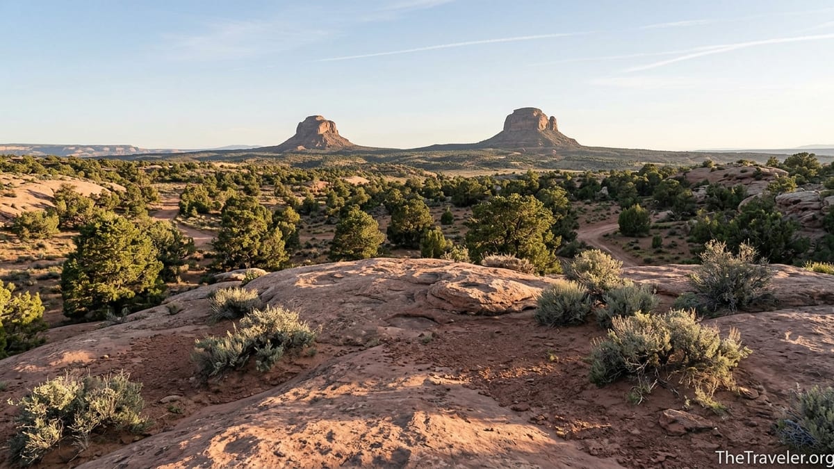
Scenic Drives and Classic Roadside Views
Even if you never shoulder a backpack, you can appreciate much of Bears Ears from the driver’s seat. One of the most memorable drives is Utah Highway 261 across Cedar Mesa. Approaching from the south near Mexican Hat, the road climbs the unpaved Moki Dugway, a series of steep, graded switchbacks carved into a sheer cliff face. Passenger cars can usually handle the ascent in dry weather, but there are no guardrails and tight turns, so nervous drivers may prefer to ascend rather than descend. From pullouts on top, you can gaze south across Monument Valley and the San Juan River country, particularly striking at sunset when buttes cast long shadows across the desert.
Once on the mesa, side roads lead west to overlooks above Grand Gulch and east toward the twin buttes that give Bears Ears its name. These roads are mostly graded dirt, passable to cautious drivers in dry conditions but prone to deep mud after storms or snowmelt. A practical strategy for many travelers is to base in Blanding or Bluff, check road status each morning at a visitor center or ranger station, then choose a drive based on the latest reports. You might spend one day looping from Blanding along Highway 95 past Comb Ridge and Butler Wash, taking in sweeping views of tilted rock fins, and another day exploring the mesa-top roads before looping down to Natural Bridges National Monument.
Indian Creek, along U.S. Highway 191 between Monticello and the Needles District of Canyonlands National Park, offers a different kind of scenic drive: a broad valley framed by vertical sandstone walls. This corridor is famous worldwide among rock climbers but is just as impressive from the pavement. Pullouts and picnic areas near Newspaper Rock, home to a dense cluster of petroglyphs etched into varnished stone, provide easy access for visitors who cannot or do not wish to hike far. A short roadside stroll can reveal faint footpaths to additional panels, though as always, keep a respectful distance and avoid tracing or chalking the images.
Because many of these roads lack services, treat each scenic drive like a miniature backcountry trip. Fill your gas tank the night before, carry at least one full-size spare tire and basic tools, and pack enough water and snacks to be comfortable if you are delayed by weather or a stuck vehicle. Afternoon thunderstorms can quickly transform a dusty track into impassable gumbo; if you encounter deep mud, the safest and most responsible decision is often to turn around before you churn up ruts that will scar the road for months.
Hiking, Camping, and Climbing Adventures
For hikers, Bears Ears offers everything from one-hour strolls to multi-day canyon immersions. Newer visitors often start with easier out-and-back routes like House on Fire, Butler Wash side canyons, or short approaches to rock art sites near Bluff. These trails typically follow washes or old tracks with minimal elevation gain, though footing can be sandy or rocky. Carry more water than you think you will need and remember that creek flow in places like Mule Canyon or Fish and Owl Canyons is highly variable. Even where water is present, it may be silty or contaminated by livestock, so treating or filtering is essential.
Experienced hikers and backpackers gravitate to Cedar Mesa’s deeper canyons, where itineraries of 2 to 5 days are common. A classic loop pairs Fish and Owl Canyons, dropping through slickrock pour-offs into cool narrows and back out onto open benches, with side trips to alcoves housing granaries or rock art. Grand Gulch, with multiple entrance and exit points like Kane Gulch, Bullet Canyon, and Collins Canyon, can be stitched together into routes spanning 20 to 40 miles. On these trips, you are responsible for finding durable campsites on sand or rock, packing out all trash and human waste, and adjusting your route on the fly if water sources are dry.
Dispersed car camping is another signature Bears Ears experience. Along the mesa-top roads radiating from Highway 261, you will find numerous previously disturbed campsites tucked among junipers or perched near canyon rims. Look for obvious signs of prior use such as rock fire rings and flat tent pads, then keep your footprint small: park on bare ground, keep tents away from vegetation, and avoid expanding sites or creating new spurs. In Indian Creek, designated BLM campgrounds provide a bit more structure, with pit toilets and metal fire rings but no hookups or showers. These campgrounds often fill on spring and fall weekends; arriving by mid-afternoon on a Thursday or traveling midweek can improve your chances of finding a spot.
Rock climbers have long regarded Indian Creek as one of the world’s premier crack climbing destinations. Vertical sandstone walls like Supercrack Buttress and Cat Wall host routes that attract climbers from across the globe. If climbing is part of your plan, pay close attention to seasonal raptor closures posted at trailhead kiosks or on BLM bulletins, and be prepared for a largely self-supported experience with no gear shops or rescue services nearby. Even if you are not a climber, it is worth stopping at a roadside pullout to watch tiny figures inch their way up the rock, highlighting just how big the cliffs really are.
Staying Safe in a Remote Desert Monument
Bears Ears feels wild not just because of its vistas but because help is far away. Distances between towns, trailheads, and campgrounds are significant, and GPS directions are not always reliable on backroads. Before heading out each day, leave a rough itinerary with someone back home, including your intended trailhead, general route, and when you expect to return to cell service. A simple satellite messenger can add an extra layer of security if your vehicle breaks down on a little-used track or you twist an ankle in a remote canyon.
Heat, dehydration, and exposure are the most common hazards. In hot months, shift your hiking to early morning or late afternoon, resting in shade or at camp during the midday sun. As a rule of thumb, carrying at least 3 to 4 liters of water per person for a moderate half-day hike is reasonable in warm weather, more if you sweat heavily or expect slow, off-trail travel. Sun protection is essential; lightweight long sleeves, a wide-brim hat, and high-SPF sunscreen will make your days far more comfortable. Sudden storms can also bring lightning to mesa tops and flash floods to canyons; if dark clouds build, avoid slot-like narrows and seek higher ground.
The terrain itself demands attention. Cryptobiotic soil crusts, a living community of organisms that holds sand in place and supports desert plants, form dark, knobby patches on the ground. Once crushed, they can take decades to recover. Hikers are expected to follow the mantra “step on rock, sand, or your own footprints,” weaving routes that avoid crusts even if that means a slightly longer path. When scrambling to viewpoints or exploring side drainages, be mindful of loose rocks and unstable ledges, particularly around ruins where centuries-old masonry blends with natural stone.
Finally, respect seasonal and wildlife-related advisories. In the Abajo Mountains section of the monument, black bears are present, so standard food storage practices apply: keep a clean camp, store food in vehicles or bear-resistant containers, and never leave packs unattended with snacks inside. In Indian Creek and other cliff-lined valleys, raptors nest on ledges; climbing closures or hiking detours are occasionally implemented to give them space. Seeing a peregrine falcon wheel above a sandstone wall or a golden eagle soaring over a canyon rim is one of the rewards of giving wildlife room to thrive.
The Takeaway
Visiting Bears Ears for its ancient sites, scenic drives, and outdoor adventures is less about checking destinations off a list and more about learning how to move thoughtfully through a living cultural landscape. With some upfront planning for permits and road conditions, a willingness to carry your own water and safety gear, and a commitment to treating every ruin and rock panel as sacred, you can experience cliff dwellings glowing in reflected light, canyon vistas with no one else in sight, and star-splashed night skies from a quiet campsite.
In return, you will leave with more than photographs. You will gain a sense of how people have lived with this land for millennia, how fragile even rock can be under the weight of modern visitation, and how much power there is in choosing to tread lightly. If you approach Bears Ears as both an adventure playground and a place of deep respect, your time there will feel richer and the monument itself will be better protected for those who follow.
FAQ
Q1. Do I need a reservation to visit Bears Ears National Monument?
For general driving and many roadside viewpoints, no reservations are required. Reservations or permits are needed for specific areas like Cedar Mesa backpacking routes and Moon House, and day-use passes are required for certain canyons such as Grand Gulch and Mule Canyon.
Q2. Where should I base myself when exploring Bears Ears?
Most travelers stay in nearby towns such as Bluff, Blanding, or Monticello, which offer basic motels, rental cabins, and campgrounds. Many people mix a few nights in town with dispersed camping on BLM lands within the monument.
Q3. What is the best time of year to visit Bears Ears?
Spring (March to May) and fall (late September through early November) generally offer the most comfortable temperatures for hiking and camping. Summer can be extremely hot in exposed areas, while winter can bring snow and muddy roads on Cedar Mesa and in the Abajo Mountains.
Q4. Are there entrance fees for Bears Ears?
There is no general entrance fee to drive into Bears Ears National Monument. However, there are fees for certain permits, including Cedar Mesa day-use passes, overnight backpacking permits, and limited-entry sites like Moon House.
Q5. Can I bring my dog to Bears Ears?
Dogs are allowed in many parts of the monument but are prohibited in several Cedar Mesa canyons, including Grand Gulch and some of its tributaries, to protect sensitive cultural sites. Even where dogs are allowed, they must be under control and kept away from ruins and rock art.
Q6. Is a high-clearance or four-wheel-drive vehicle necessary?
Many main highways and some graded dirt roads can be driven in a standard passenger car in dry conditions. A high-clearance vehicle is strongly recommended for rougher Cedar Mesa and forest roads, especially after storms, and four-wheel drive can be important when roads become rutted or muddy.
Q7. How can I visit ancient sites without causing damage?
Stay on established paths or durable surfaces like rock and sand, keep a respectful distance from walls and doorways, never enter rooms or climb on masonry, and leave artifacts exactly where you find them. Avoid touching rock art and resist creating social media posts that reveal precise locations of fragile sites.
Q8. Are guided tours available in Bears Ears?
Yes. Several local outfitters based in Bluff, Blanding, and other nearby communities offer guided day hikes and backpacking trips that focus on cultural history and natural features. Guided trips are a good option if you are new to desert travel, want deeper context, or prefer not to manage permits and navigation on your own.
Q9. What should I pack for a typical day hike?
Plan to carry ample water, usually at least several liters per person depending on temperature and distance, along with sun protection, snacks, a map or downloaded GPS track, a basic first-aid kit, and a light jacket. In more remote canyons, trekking poles and a small water filter can also be useful.
Q10. Is cell phone coverage reliable inside the monument?
Cell coverage is limited to highway corridors and a few high points. Once you drop into canyons or drive onto more remote mesas, you should not rely on your phone for calls, navigation, or weather updates. Download maps in advance and consider carrying a satellite communicator for emergencies.