
Bears Ears National Monument in southeast Utah is a place of sweeping slickrock mesas, deep sandstone canyons and one of the highest concentrations of cultural sites in the United States. It is also a destination where planning ahead matters. Visitor services are sparse, cell coverage is patchy and many of the best hikes are reached only by dirt roads. This guide walks you through how to find accurate maps, choose suitable hiking routes and understand the current rules, permits and safety considerations before you go.
Get the latest updates straight to your inbox!
Understanding Bears Ears: Layout, Access & Orientation
Bears Ears National Monument covers more than a million acres of public land in San Juan County, Utah, spread across mesas, canyons and high forest around the twin buttes known as the Bears Ears. The monument is co-managed by the Bureau of Land Management and the U.S. Forest Service in consultation with a coalition of Native American tribes, and it does not function like a traditional national park. There are no entrance gates, no park-run lodges and no gas stations inside the monument. Nearby towns such as Bluff, Blanding, Monticello, Mexican Hat and Moab are your bases for fuel, groceries and lodging.
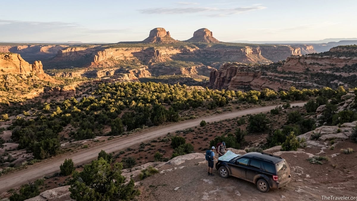
The monument is broadly experienced in two main regions. To the north, the Indian Creek area sits between Monticello and the Needles District of Canyonlands National Park and is known for its soaring crack-climbing walls, open desert views and a handful of developed BLM campgrounds. Farther south and west, Cedar Mesa and the Shash Jaa unit encompass a maze of canyons such as Mule Canyon, Grand Gulch and Slickhorn that shelter ancestral Puebloan cliff dwellings and rock art. Understanding which region you plan to visit helps you choose the right maps, access roads and permit information.
Primary paved access routes include U.S. 191 running north-south between Moab, Monticello and Blanding, U.S. 163 through Monument Valley and Bluff, and Utah Highways 95, 261 and 211, which cut across Cedar Mesa and Indian Creek. From these highways, graded dirt roads like Comb Wash Road, Cottonwood Wash Road and various spur tracks lead toward popular trailheads. Conditions on these roads can change quickly after storms. Before you commit to a remote dirt track, especially in a rental vehicle, talk with rangers in Monticello or at Kane Gulch Ranger Station about current access and whether high clearance is recommended.
Because Bears Ears is large and somewhat fragmented, driving times can surprise first-time visitors. For example, it can take around 1.5 hours to drive from the town of Monticello to the House on Fire trailhead in Mule Canyon, and a similar amount of time from Bluff to popular Cedar Mesa trailheads along Utah 95. When planning day hikes, factor in these long approaches along with the desert heat and short daylight hours in shoulder seasons.
Finding Reliable Bears Ears Maps
In such a sprawling landscape, having accurate maps is essential. The Bureau of Land Management publishes an official Bears Ears National Monument map that shows monument boundaries, main access roads, trailheads, campgrounds and land management jurisdictions. This map is available as a printable PDF and as a georeferenced file you can load into offline navigation apps. For on-the-ground use, many travelers print the overview map at home and combine it with a detailed road atlas of Utah that shows minor BLM roads and topography.
For Cedar Mesa and Grand Gulch, the BLM also produces a Cedar Mesa trip planner and a separate recreation map that highlight canyons with permit systems, trail access points and regulations. These documents are updated periodically and are particularly useful if you plan to hike or backpack in Grand Gulch, Slickhorn Canyon or Kane Gulch. They are often stocked at BLM offices in Monticello and at Kane Gulch Ranger Station, and non-profit bookstores in Moab and Monticello frequently sell waterproof topographic maps that cover Cedar Mesa at a larger scale suitable for navigation.
Digital navigation is a helpful supplement but should not be your only tool. Popular apps such as Gaia GPS, AllTrails and onX Backcountry usually show routes into places like Lower Mule Canyon, House on Fire Ruin, Butler Wash and the approach roads along Comb Wash. However, user-created routes may not reflect current closures, cultural site protections or permit requirements. When you download offline maps for the area, cross-check trail lines with BLM information and be prepared to turn around if signs in the field indicate a closure or restricted area.
Because cell service across Bears Ears is inconsistent, plan to download all digital maps in advance while you have strong Wi-Fi in towns like Moab, Monticello or Blanding. Many hikers also carry printed USGS 7.5-minute topo maps for the exact canyons they intend to explore, which can be purchased from mapping websites or regional outdoor shops in Moab. A simple map case or large zip-top bag keeps these paper maps from being shredded by canyon winds.
Key Hiking Areas and Classic Routes
Bears Ears offers everything from short, family-friendly walks to multi-day backpacking routes through remote canyons. One of the most popular introductory hikes is the House on Fire trail in Mule Canyon, off Utah Highway 95. The route is roughly 3 miles round trip, following a sandy wash with almost no elevation gain. After about an hour of easy walking, you reach an ancestral Puebloan dwelling built into an alcove where the textured sandstone roof catches the light in a way that resembles flames. Because this site has become an iconic photo location, arriving early in the day or in shoulder seasons can help you avoid crowds and allow time to appreciate the site quietly and respectfully.
Nearby, Butler Wash offers several access points along the east side of Comb Ridge between Bluff and Blanding. Short hikes here, often 1 to 4 miles round trip, lead to alcoves with ruins, rock art panels and sweeping views over the sinuous sandstone fins of Comb Ridge. Some trailheads are signed simply as “Butler Wash Ruins” parking areas with small information kiosks. These are good choices if you want a taste of Bears Ears archaeology without committing to a long canyon trek, but you still need to be prepared with water, sun protection and navigation skills, as social trails can branch and fade.
For more committed hikers and backpackers, the Grand Gulch and Kane Gulch system on Cedar Mesa offers multi-day routes through deep canyons lined with cultural sites, seasonal water sources and cottonwood groves. Trips range from overnight loops that descend Kane Gulch and exit via Bullet Canyon to 3 to 5 day traverses deeper into Grand Gulch. Because route-finding, water availability and regulations are more complex here, these trips are best for experienced desert hikers who are comfortable carrying 3 to 4 liters of water per person and using detailed topo maps. Many backpackers time their visits for April to early May or late September to October, when temperatures are cooler and water is more likely to be flowing.
In the northern part of the monument, the Indian Creek area provides a different style of hiking. While the corridor is best known among rock climbers for its splitter sandstone cracks, casual hikers can walk along the base of the cliffs, follow social paths to viewpoints or explore short trails near campgrounds like Creek Pasture and Hamburger Rock. Because most routes here are informal rather than signed backcountry trails, you will often be walking along old roads, washes or cattle paths. Good footwear for rocky desert terrain and comfort reading terrain features is especially important.
Permits, Regulations and Cultural Respect
Unlike many national park units, Bears Ears currently does not charge a monument-wide entrance fee. However, several canyons on Cedar Mesa have permit requirements to control use and protect the high density of archaeological sites. Day-use permits for popular canyons such as Grand Gulch, Slickhorn Canyon, Fish and Owl Canyons, the forks of Mule Canyon, Road Canyon and Lime Creek are typically obtained on-site via self-serve fee stations at trailheads or at kiosks on the mesa top. Fees are modest, often in the range of a few dollars per person per day, but you should bring exact cash and a pen because remote kiosks may not have change or supplies.
Overnight backpacking in Grand Gulch and associated canyons requires advance permits with quotas. Many permits are reserved online ahead of time, while a limited number may be available as walk-in permits at Kane Gulch Ranger Station on a first-come, first-served basis. The ranger station, located on Utah Highway 261 near the top of Cedar Mesa, is generally open limited hours during the main spring and fall seasons. Before planning a backpacking trip, check the latest BLM information about seasonal dates and office hours, and consider calling a few days ahead to clarify permit availability and water reports.
Bears Ears is first and foremost a living cultural landscape for Indigenous communities including Navajo, Hopi, Ute and Zuni peoples. When you visit cliff dwellings and rock art panels, treat them as you would places of worship. Do not touch rock art or walls, do not enter ruins or sit on structural stones, and avoid rearranging artifacts or stones on the ground. Even stacking “souvenir” rocks for photos can damage fragile surfaces or confuse future archaeologists. Many sites are intentionally not signed or described in detail to reduce impacts. If you discover a site that is not mentioned in guidebooks or on signs, enjoy it quietly without posting exact locations online.
Dogs are allowed in much of the monument but may be restricted in some archaeological areas, and you are expected to keep pets under control and away from structures and rock art. Drone use in Bears Ears is tightly regulated or prohibited in many areas due to wildlife disturbance and privacy concerns at cultural sites. Fire regulations change seasonally. In dry periods, fire bans may prohibit campfires even in existing rings. Carry a portable stove and be prepared to cook without open flames if conditions require it.
Visitor Centers, Seasonality and On-the-Ground Information
There is currently no single, official federal visitor center inside Bears Ears itself, which can surprise travelers used to national park gateways with large staffed facilities. Instead, information is spread across several small offices and partner centers. The Kane Gulch Ranger Station on Cedar Mesa serves as the primary BLM contact point for Grand Gulch and surrounding canyons. During the core spring season from roughly March through mid-June and again in the fall from September through October, rangers there provide maps, permits and current conditions each morning. Hours and dates vary year to year, so always confirm before planning to arrive for a permit.
In the surrounding communities, BLM and Forest Service offices in Monticello and Moab can provide monument maps, road information and trip-planning advice. Non-profit partners such as the Canyonlands Natural History Association operate bookstores and information desks where you can purchase topographic maps, guidebooks and field guides, and get suggestions for hikes that match your group’s experience level. In Bluff, a small Bears Ears-focused education center run by local organizations often provides cultural context, exhibits and guidance on visiting sites respectfully.
Seasonality is a major factor in trip planning. Summer temperatures across Cedar Mesa and Indian Creek frequently climb into the 90s Fahrenheit or higher, and many hikes traverse exposed slickrock or sandy washes with little shade. Spring and fall are the most popular times for hiking and backpacking, with daytime highs often in the 60s to 80s Fahrenheit and cooler nights. Winter brings snow to the higher elevations near the Bears Ears buttes and the forested upper Shash Jaa unit, and some dirt roads can become impassable due to mud. Early spring can also be very muddy as snow melts, even if temperatures feel friendly in the middle of the day.
Because conditions change from year to year, especially regarding water availability in backcountry canyons, calling a ranger station or local BLM office within a week of your planned trip is one of the best ways to get current, practical advice. Rangers can tell you, for example, whether pools in Kane Gulch are reliable at the moment, if a specific road has washed out after a storm, or if there are any temporary restrictions related to cultural resource protection or wildland fire activity.
Camping, Lodging and Practical Logistics
Developed camping inside Bears Ears is concentrated in the Indian Creek corridor north of Newspaper Rock. BLM campgrounds such as Hamburger Rock, Superbowl and Creek Pasture offer basic sites with picnic tables, fire rings and vault toilets, typically on a first-come, first-served basis with nightly fees that are modest by national standards. There is no electricity, hookups or potable water at these campgrounds, so visitors usually fill water jugs in Monticello or Moab before heading into the monument. These campgrounds can fill quickly on spring and fall weekends, particularly when climbers converge on Indian Creek, so arriving early in the day can improve your chances of finding a site.
Across Cedar Mesa and along roads like Comb Wash, dispersed camping is common on existing dirt pullouts and previously used sites on BLM land. Regulations typically require camping at least a specified distance from cultural sites, water sources and cliff edges, and campers are encouraged to use durable surfaces rather than creating new camps. Because there are no services at these dispersed sites, you must pack out all trash, use a portable toilet system where required, and follow fire restrictions. Bringing a five-gallon water container from town and planning simple, low-fuel meals can greatly simplify dispersed camping.
For travelers who prefer a roof and more amenities, small motels, bed and breakfasts and vacation rentals can be found in Bluff, Blanding and Monticello, generally in the range of budget to mid-range prices. For example, a basic motel room in Bluff in the spring shoulder season may cost somewhere between roughly 100 and 180 U.S. dollars per night depending on demand, while more upscale lodges or casitas can run higher. Moab, about 1.5 to 2 hours from some northern monument locations, has a broader spectrum of accommodations, from hostels to high-end hotels, but is farther from Cedar Mesa trailheads.
Gas stations are limited once you leave the main towns. A practical rule is to fill your tank whenever you pass through Blanding, Monticello or Bluff, rather than assuming there will be fuel closer to the trailhead. Many visitors carry an extra water jug in the vehicle and at least one full-size spare tire because sharp rocks on unpaved roads can cause flats. Even if you are only planning day hikes from a motel base, it is wise to pack extra snacks, a headlamp and warm layers in the car, in case a hike takes longer than expected or a road issue delays your return.
Safety, Weather and Navigating Remote Terrain
Hiking in Bears Ears involves real desert hazards. Heat, dehydration and sun exposure are the most common issues. Many local guides suggest carrying at least 3 liters of water per person for a moderate day hike, more if temperatures are high or if your route involves significant elevation gain. Lightweight sun shirts, broad-brimmed hats, sunscreen and lip balm with UV protection can make a noticeable difference in your comfort over a full day on slickrock. In spring and fall, layering is important because mornings can be near freezing while afternoons are warm.
Flash floods are a particular concern in slot-like sections of canyons and washes. Even if the sky above you is blue, storms many miles away can send walls of water down normally dry channels. Before hiking into narrow canyons like some side forks of Grand Gulch or Mule Canyon, check the forecast for the broader region, not just your immediate location. If you hear thunder, see rapidly building clouds or notice water beginning to run cloudier or faster in a wash, move to higher ground promptly and avoid trying to outrun floodwaters in narrow sections.
Navigation in Bears Ears often relies on reading the land rather than simply following a single, well-signed trail. Many routes follow cairned paths across slickrock, stretches of sandy wash or old stock trails that fade in and out. A small misstep can lead you from a well-trodden route onto a fragile biological soil crust, which is vital to desert ecosystems. When in doubt, stop, consult your map and GPS track and look for durable surfaces like bare rock. If you realize you have lost the route, it is usually safer to retrace your steps carefully rather than pushing forward blindly.
Because cell coverage is patchy or absent in much of the monument, consider carrying a satellite communicator or personal locator beacon if you are venturing into remote canyons. Even a basic, rented satellite messenger that can send preset check-in texts gives friends and family a way to know you are safe when you are out of range. Always leave a trip plan with someone back home that lists your intended trailheads, rough route and expected return time. Something as simple as a handwritten note left at your motel front desk or a message to a trusted friend can greatly assist rescuers if something goes wrong.
The Takeaway
Bears Ears National Monument rewards travelers who prepare thoughtfully and approach the landscape with humility. Unlike marquee national parks with shuttle buses and paved loop trails, this is a place where you navigate long stretches of open road, read subtle terrain cues and carry responsibility for your own safety and impact. With reliable maps in hand, a clear understanding of permit rules and a deep respect for the cultural sites you will encounter, even a first-time visitor can experience the quiet magic of canyons like Mule Canyon, Butler Wash or Grand Gulch.
Before you go, think carefully about your group’s experience level and choose routes that match your skills, whether that is a short walk to a signed ruin overlook or a multi-day backpack through remote wilderness. Stop at ranger stations and local education centers when they are open, listen to Indigenous voices about the meaning of this place and adjust your plans to current conditions rather than to a rigid checklist of must-see locations. If you do, you are far more likely to return home with not only beautiful photographs, but also a deeper understanding of why Bears Ears has become such an important landscape for conservation and cultural preservation.
FAQ
Q1. Do I need a permit to hike in Bears Ears National Monument?
Permits are not required for every hike, but several Cedar Mesa canyons such as Grand Gulch, Slickhorn and the forks of Mule Canyon require day-use permits, and overnight backpacking permits are mandatory in many of those canyons. Check current BLM guidance for specifics before you go.
Q2. Where can I get an official Bears Ears map?
Official overview and recreation maps are produced by the Bureau of Land Management and are available as downloadable PDFs and georeferenced files, and in printed form at BLM offices in Monticello and Moab, Kane Gulch Ranger Station during its open season, and non-profit bookstores in the region.
Q3. Is there a main visitor center inside Bears Ears?
There is currently no single, federal visitor center inside the monument. Instead, visitors rely on smaller facilities like Kane Gulch Ranger Station on Cedar Mesa, BLM and Forest Service offices in nearby towns, and partner-run education centers in communities such as Bluff.
Q4. What is the best season to hike in Bears Ears?
Spring and fall are generally the most comfortable times to hike, with moderate temperatures and more reliable water in some canyons. Summer can be extremely hot on exposed slickrock, while winter brings snow and mud to higher elevations and some dirt roads.
Q5. Can I visit House on Fire Ruin without a guide?
Most visitors hike to House on Fire independently using maps and established information about the trailhead along Utah Highway 95. The route is relatively short and not technically difficult, but you should still carry navigation tools, water and sun protection and follow all cultural site protection guidelines.
Q6. Are there developed campgrounds in Bears Ears?
Yes, but they are limited. The Indian Creek area north of Newspaper Rock has BLM campgrounds such as Hamburger Rock, Superbowl and Creek Pasture with basic amenities like tables and vault toilets. Elsewhere, camping is mainly in dispersed sites along existing dirt roads where no services are provided.
Q7. How much water should I carry for a day hike?
In warm seasons, many local experts suggest starting with at least 3 liters of water per person for a moderate day hike, more if temperatures are high, your route is long or you are unsure about water availability along the way.
Q8. Is Bears Ears suitable for families and beginner hikers?
Yes, if you choose appropriate routes and prepare carefully. Shorter hikes such as the signed Butler Wash overlook or the lower portion of Mule Canyon can be suitable for fit beginners, provided you carry enough water, sun protection and navigation aids and keep children well away from cliff edges and cultural structures.
Q9. Can I bring my dog on hikes in Bears Ears?
Dogs are allowed in many parts of the monument, but they must be under control and kept away from archaeological structures and rock art. Some areas may have additional restrictions, so verify rules for specific canyons or trailheads and always pack out pet waste.
Q10. What should I do if I find an undocumented ruin or artifact?
If you encounter a cultural site that is not marked on maps or described in guidebooks, enjoy it quietly from a distance. Do not touch walls or artifacts, do not enter structures and avoid sharing precise locations online. Treat it as a living sacred place and leave it exactly as you found it.