
Say “New Jersey” and most travelers picture parkway traffic, casino towers in Atlantic City, and rows of shore houses facing a crowded beach. Drive just a few miles inland, though, and the state dissolves into something startlingly different: a 1.1-million-acre expanse of pitch pine forest, cedar swamps, tea-colored rivers, and forgotten company towns known as the Pine Barrens. Spend a day here and it becomes clear that this is not the New Jersey of stereotypes, but a wild, quietly spectacular landscape that feels more like an off-the-map national park than the densest state in America.
Get the latest updates straight to your inbox!
A Vast Wilderness Hiding in Plain Sight
The Pine Barrens, or Pinelands, stretch across seven counties in southern New Jersey, forming the core of the country’s first National Reserve. From the outside, it is easy to miss. You exit the Atlantic City Expressway near Hammonton or pull off Route 206 near Atsion, and suddenly the sprawl thins into sandy shoulders and low, scruffy pine forest. Only when you drive for half an hour without seeing a strip mall do you realize how large and empty this place really is.
For visitors used to boardwalk crowds in Ocean City or Hoboken’s waterfront skyline, the stillness is disorienting. Here the defining sound is wind moving through the pitch pines, not trucks on the Turnpike. You might pass a single general store, a volunteer firehouse, and then nothing but power lines and dirt roads stretching into the trees. Cell service flickers in and out. At night, light pollution drops enough that the Milky Way becomes visible, which comes as a genuine surprise to anyone who just left Philadelphia or New York a short drive away.
This sense of remoteness is not a trick of perception. The Pinelands cover about a fifth of New Jersey’s land area, yet contain only a tiny fraction of its population. It is one of the largest unbroken wild landscapes on the Eastern Seaboard between Richmond and Boston, a fact that still astonishes first-time visitors pulling canoes off car roofs in Wharton State Forest or Brendan T. Byrne State Forest.
Cedar Water, Pitch Pines, and an Almost Alien Ecology
The look and feel of the Pine Barrens are unlike the leafy, suburban New Jersey most visitors know. The soil is pale, sandy, and acidic. Out of it rises a low forest of pitch pines and scrub oak that has evolved to burn in periodic wildfires. Many trees are gnarled and stunted, more like something from coastal North Carolina than from the land of commuter rail lines. In some pockets, such as around the Forked River Mountains and the Rechnitz Pine Barrens Preserve, the forest is so open and scrubby that it resembles a dry heath, with twisted pine and waist-high oak dominating shallow ridges.
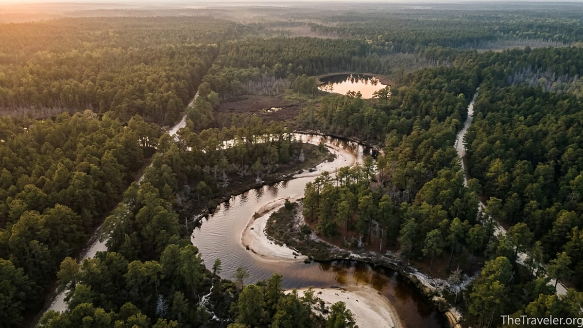
Then the terrain drops a few feet and everything changes. Shallow streams like the Mullica, Wading, Batsto, Oswego, and Wading Rivers snake through swaths of Atlantic white cedar and black gum swamp. The water looks like strong iced tea: stained brown by tannins leaching from cedar roots and peat but clean enough to drink after filtering. Paddling a rented canoe from an outfitter in Chatsworth or Atsion, you glide past sandbanks the color of bone and under arching cedar branches that almost block out the sky.
Because of its nutrient-poor soils and fire-adapted ecology, the Pine Barrens harbor plants and animals that feel closer to the Deep South or a science-fiction set than to a state turnpike rest stop. Carnivorous pitcher plants and sundews cluster at the edges of boggy clearings. At dusk in June, you may hear the nasal call of the Pine Barrens tree frog, a species that has become an icon of the region’s conservation efforts. Rare wild orchids hide in sphagnum mats and along shady seeps; hikers occasionally spot delicate blooms only a botanist could name, crouching beside muddy trails in preserves near Browns Mills or Bridgeton.
Ghost Towns, Company Villages, and Industrial Ruins
Travelers who come expecting quaint Victorian town centers quickly discover that the most intriguing “settlements” in the Pine Barrens are often abandoned. This region boomed in the 18th and 19th centuries on bog iron, glassmaking, charcoal, and timber. When those industries collapsed, entire communities withered, leaving behind sandy roads, cellar holes, and collapsing brick stacks slowly being taken back by the forest.
Batsto Village, in Wharton State Forest, is the most accessible introduction to this forgotten chapter. Once a bustling ironworks and later a company town built around a glass factory and agriculture, it is now preserved as a historic site with a mansion, workers’ houses, a sawmill, and a general store. Visitors can walk from the parking lot beside Batsto Lake straight into streets that feel frozen in the late 1800s. It is not a theme park; the buildings retain a weathered authenticity that pairs strangely well with the surrounding wilderness of pitch pine and cedar swamp.
Elsewhere the remains are subtler. Near the hamlet of Ong’s Hat, long a magnet for conspiracy lore, sandy tracks lead past old foundations and overgrown cranberry bog dikes. In other corners of the Pinelands, explorers who follow narrow sugar-sand roads off County Road 563 or Route 72 may come across crumbling furnace ruins, rusted car frames, and moss-covered stone walls in the middle of seemingly endless trees. These are tangible reminders that the Pine Barrens, however untamed they seem today, are not untouched wilderness but a landscape shaped and then largely abandoned by earlier waves of industry.
Cranberry Bogs, Blueberries, and Working Landscapes
One of the most surprising sights in the Pine Barrens is the sudden appearance of an intensely managed agricultural landscape in the middle of all that forest. Around towns such as Chatsworth and Whitesbog, broad geometric basins spread out on either side of the road, separated by low dikes and threaded with narrow canals. In autumn, these basins fill with shallow water that glows crimson as millions of cranberries float to the surface during harvest.
Visitors driving between Route 70 and Route 72 in late September or October might catch a harvest in progress, with workers in waders guiding floating berries toward conveyer belts while tractors churn along the dikes. Family-owned farms, some with histories stretching back to the 19th century, still form the backbone of this industry. A few welcome visitors for seasonal tours, letting travelers see how the same sandy, acidic soil that once frustrated colonial farmers now supports one of the country’s major cranberry-producing regions.
Blueberries add another edible layer to the Pine Barrens story. In the early 1900s, a local grower successfully cultivated highbush blueberries at Whitesbog, helping transform the wild berries that carpet the forest understory into a commercial crop. Today, the town of Hammonton, on the western edge of the Pinelands, bills itself as a blueberry capital, surrounded by fields and packing houses. Travelers who time their visit for early summer can find roadside stands selling pints of berries picked that morning, a far cry from the funnel cakes and saltwater taffy associated with the boardwalks an hour away.
Rivers, Trails, and Quiet Adventures
For outdoor travelers, the Pine Barrens offer a style of adventure that feels almost Canadian in its quiet and scale, yet lies barely an hour from both Center City Philadelphia and Atlantic City’s casino hotels. Instead of big-mountain vistas, the rewards here are intimate and immersive: paddling narrow rivers, walking long, flat trails through fire-scarred forest, or biking sand roads that twist past bogs and through ghostly cedar swamps.
Canoeing or kayaking is one of the best ways to experience the region. On a typical weekend, visitors rent boats from liveries along Atsion Road or near the Wading River and arrange a shuttle. A classic beginner trip might take you from the put-in at Hawkins Bridge or Oswego Lake down to a take-out near Harrisville Lake, five to seven miles of easy current through tea-colored water. Even on a summer Saturday, you can go a surprising amount of time seeing only a handful of other paddlers, especially compared with the bumper-to-bumper traffic heading to Seaside Heights or Wildwood.
Hikers can choose from short, family-friendly loops like the Cranberry Trail in Brendan T. Byrne State Forest to longer treks on the Batona Trail, a pink-blazed footpath that runs roughly 50 miles through three state forests. The walking itself is straightforward, with minimal elevation gain, but the experience is distinctive: narrow paths threading through stunted pine, open bogs filled with reeds, and stretches where fire has blackened trunks yet left pockets of green scrub oak untouched.
Cyclists, especially those with gravel or fat-tire bikes, find a labyrinth of sand roads that range from hard-packed and fast to soft and technical. It is easy to underestimate how remote you can feel just a few miles from a paved road. Riders planning day trips quickly learn to bring more water than they think they need, a paper map in case phones lose signal, and a healthy respect for the homogeneity of the landscape. One sandy intersection can look very much like the next.
Legends, The Jersey Devil, and Places That Feel Haunted
Beyond its ecology and history, the Pine Barrens have a personality shaped by stories. For generations, locals and visitors have swapped tales of the Jersey Devil, a winged creature said to haunt these woods since colonial times. Whether you regard it as folklore, a cautionary tale, or simply a marketing hook, the legend adds a layer of drama to late-night drives down unlit forest roads and to the sound of branches scraping a tent at 2 a.m.
Certain places carry especially heavy reputations. The Blue Hole, a small, perfectly round, intensely blue pool near the border of Winslow and Monroe townships, has been the subject of newspaper features, local TV segments, and countless social media posts. Some call it bottomless, others an old quarry or a spring-fed pond, and many fold it directly into Jersey Devil lore. Getting there typically involves a drive down unmarked sand roads in the Winslow Wildlife Management Area and then a walk through the woods, which contributes its own sense of dislocation. When you arrive, the combination of unnaturally clear water and encircling pines explains why the stories took root.
Elsewhere, feelings of eeriness arise less from specific legends and more from contrast. Someone who grew up in North Jersey, used to short hikes that always seem to end at a suburban backyard or highway overpass, can be unsettled by just how far the Pine Barrens let you go without hitting development. Forest roads can narrow until branches brush both sides of a vehicle, and long, straight stretches over sugar sand can seem to lead into nothing. It is easy to understand why the area has inspired horror stories, Reddit threads about creepy encounters, and that famously unsettling “Pine Barrens” episode of The Sopranos, even if the show filmed many of its scenes elsewhere.
Planning a Visit: Practical Differences From the Jersey Shore
Travelers who know New Jersey primarily through oceanfront towns quickly discover that visiting the Pine Barrens works very differently from a day at the beach. There are no boardwalks, no rows of hotels facing the water, and few formal visitor centers once you leave the main highways. That is part of the appeal, but it also means you need to plan more deliberately than you would for a spontaneous boardwalk stroll in Asbury Park.
Most visitors base themselves in nearby gateway towns such as Hammonton, Egg Harbor City, or Barnegat, where small motels and chain hotels sit within a half-hour drive of major trailheads and river put-ins. From Philadelphia, a common approach is to day-trip: leave early, reach Atsion Lake or Batsto Village in under 90 minutes, spend the day paddling or hiking, then return to the city for the night. Travelers from farther afield sometimes combine a couple of nights in the Pinelands with a couple of nights on the shore, splitting time between cedar water and salt water.
Because services thin out quickly once you leave town centers, it is wise to treat any Pine Barrens outing more like a low-key backcountry trip than a stroll in a city park. Fill the gas tank before heading into Wharton or Bass River State Forest. Carry more water than you think you will drink, especially in humid summer months. Download maps offline and carry a paper backup if you plan to wander sand roads or use little-known trailheads. And understand that many unpaved roads are rutted or deeply sandy; a standard car can manage some, but others are better left to high-clearance vehicles or explored on foot or bike.
In return for that bit of forethought, you get an experience of New Jersey that feels almost secret: an orange-pink sunset reflecting off a cedar-stained lake; the smell of sun-warmed pine needles baking on an August afternoon; a stretch of Batona Trail where you cannot hear any road noise at all. For many travelers, these quiet, low-drama moments end up as memorable as any casino floor or roller coaster on the boardwalk.
The Takeaway
The Pine Barrens overturn almost every cliché about New Jersey. Instead of traffic jams and shore houses stacked shoulder to shoulder, you find long horizons of pitch pine, cedar swamps, cranberry bogs, and rivers the color of strong tea. Rather than neon-lit promenades, there are dark night skies, ghost town ruins, and stories traded around campfires about things that may or may not rustle just beyond the tree line.
For travelers willing to look beyond the Turnpike view of the state, the Pinelands offer a rare combination of accessibility and wildness. You can paddle all day and still sleep in a hotel a short drive away, or build a road trip that pairs an afternoon exploring Batsto Village with an evening walking the Atlantic City boardwalk. Most of all, you come away with a new mental map of New Jersey, one in which the state is not just suburbs and shore but also a vast, resilient forest that feels, in the best possible way, like it belongs to another world.
FAQ
Q1. Where exactly are the New Jersey Pine Barrens?
The Pine Barrens cover a large swath of southern New Jersey, roughly between the Philadelphia suburbs and the Atlantic coast, stretching across parts of Ocean, Burlington, Atlantic, Camden, Gloucester, Cumberland, and Cape May counties.
Q2. How far are the Pine Barrens from popular Jersey Shore towns?
In many places the forest begins just 20 to 30 minutes inland from the shore. For example, you can drive from Atlantic City to trailheads in Wharton State Forest or Bass River State Forest in under an hour, depending on traffic.
Q3. Do I need special equipment to explore the Pine Barrens?
For basic day hikes on marked trails, standard walking shoes, water, sun protection, and insect repellent are usually sufficient. Canoe and kayak liveries provide boats and safety gear for river trips, but anyone venturing onto unpaved sand roads should be cautious about vehicle clearance and carry extra water and navigation tools.
Q4. Is it safe to visit the Blue Hole or other legendary sites?
Many visitors hike to the Blue Hole and similar spots without trouble, but the areas are remote, unmarked, and can have steep, unstable banks or deep cold water. Travelers should treat these sites with caution, avoid swimming where conditions are unclear or warnings are posted, and remember that rescue services may be far away.
Q5. Are there campgrounds in the Pine Barrens?
Yes, several state forests and private operators offer campgrounds ranging from tent sites and rustic cabins to RV spots. Places like Wharton State Forest and Brendan T. Byrne State Forest have developed campgrounds, some with lakeside settings, but advance reservations are often recommended in peak seasons.
Q6. What is the best time of year to visit?
Spring and fall are often ideal, with milder temperatures, fewer insects, and colorful changes in the forest and bogs. Summer offers warm river paddling and long daylight but can be hot and buggy, while winter brings a stark, beautiful quiet and far fewer visitors, though some services may be limited.
Q7. Can I swim in the rivers and lakes?
Swimming is allowed in designated areas, such as certain state forest lakes with guarded or marked swimming beaches in season. Many rivers are shallow and inviting, but currents, submerged logs, and changing conditions mean visitors should enter the water cautiously and follow any posted regulations.
Q8. Are there guided tours for first-time visitors?
Yes, several local outfitters and nature centers offer guided canoe and kayak trips, naturalist-led walks, and seasonal programs that introduce visitors to Pine Barrens ecology, history, and folklore. These can be useful for travelers unfamiliar with the region’s terrain and navigation challenges.
Q9. Is off-roading allowed on Pine Barrens sand roads?
Certain unpaved roads in the Pinelands are legal for street-legal vehicles, but off-road driving off established roads is prohibited and can damage fragile habitats. Visitors should check current regulations, stay on designated routes, and avoid deep sand or flooded sections that could lead to getting stuck or requiring rescue.
Q10. How is visiting the Pine Barrens different from a typical New Jersey beach trip?
Instead of boardwalks, arcades, and dense lodging, you find long stretches of forest, sparsely populated towns, and limited services once you leave main roads. A Pine Barrens visit usually involves more planning, self-sufficiency, and quiet outdoor activities like paddling and hiking, offering a calm, wilderness-focused counterpoint to the energy of the Jersey Shore.