
More news on this day
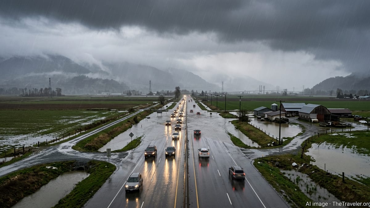
Northern Vietnam’s most popular tourism corridors are bracing for days of intense monsoon rain, with meteorological bulletins warning of up to 250 millimeters of rainfall that could trigger flash floods, landslides and severe transport disruption across Hanoi, Sapa, Ha Giang, Cao Bang and Ha Long Bay.
Get the latest news straight to your inbox!
Forecasters Flag Dangerous Multi Day Rainfall Event
Weather forecasts issued on June 29 indicate that a strong monsoon pattern combined with converging low pressure is set to deliver prolonged heavy rain across the northern region, including the Red River Delta and the northern mountains. Vietnamese language bulletins describe a broad swathe of the country’s north facing intense showers, isolated downpours and embedded thunderstorms, with mountainous provinces highlighted as particularly exposed.
Rainfall totals are expected to vary widely, but projections for some upland areas and coastal zones mention accumulations that could reach or exceed 200 to 250 millimeters within a short period. Publicly available information notes that similar multi day events in recent years have rapidly overwhelmed drainage systems, swollen small rivers and triggered fast moving floodwaters in steep terrain.
In the capital Hanoi, where storm sewers are frequently strained by tropical downpours, forecasts point to repeated bursts of heavy rain through the monsoon pulse. While the city sits outside the highest landslide risk zones, transport congestion, urban flooding and delayed departures are all considered likely knock on effects as the weather system peaks.
Further north, the same pattern is poised to sweep across Lao Cai, Ha Giang, Cao Bang and Quang Ninh provinces, linking Sapa, the Ha Giang Loop and Ha Long Bay in one broad risk area. Forecasters have repeatedly stressed that these upland and coastal tourist centers, popular in June and July with domestic and international visitors, combine fragile slopes, twisting roads and confined valleys that can magnify the impacts of extreme rain.
Flash Flood and Landslide Threat Along Iconic Mountain Routes
The greatest immediate concern focuses on the northern mountains, where steep gradients and deforested slopes have historically produced sudden flash floods and landslides during monsoon bursts. Recent coverage from Vietnamese and regional outlets has already documented destructive floods and slope failures this June in provinces such as Cao Bang, Ha Giang, Lai Chau and Tuyen Quang, with homes inundated, rural bridges damaged and key roads temporarily cut.
The network of national highways and provincial roads that forms the famous Ha Giang Loop is especially vulnerable. This circuit, anchored on National Highway 4C and local mountain roads, traverses cliff lined passes and narrow valleys that can funnel runoff and destabilize rocky hillsides. Reports from previous rainy seasons show multiple instances of rockfall, mudslides and collapsed road sections after intense storms, forcing closures and leaving travelers stranded in remote communities.
Nearby Sapa in Lao Cai province faces similar terrain related hazards. The access corridor via National Highway 4D has seen periodic landslides and mudflows in recent years, and coverage of earlier June storms this month described debris blocking sections of the route and isolating upland areas for several hours. With heavy rain again on the way, authorities are widely expected to prioritize monitoring of slopes and river levels along this corridor.
In Cao Bang, where recent downpours flooded hundreds of houses and submerged streets under more than half a meter of water, renewed heavy rain could rapidly reactivate saturated hillsides. The province’s karst valleys, home to waterfalls and caves that draw growing numbers of visitors, are at particular risk of fast rising streams and localized torrents if the forecast totals materialize.
Coastal and Inland Transport Networks Face Disruption
Beyond the direct danger from rapidly moving water and collapsing slopes, planners are also watching for a broader transport slowdown across northern Vietnam’s tourism belt. Reports on earlier June events show that heavy rain and runoff have already interrupted traffic on several mountain passes and smaller roads, forcing temporary closures and diversions while work crews cleared mud and debris.
Rail and road links into Lao Cai and the highlands are considered potential choke points during intense weather. When surrounding rivers rise and slopes fail, passenger trains and long distance buses can be delayed or canceled, breaking connections between Hanoi, Sapa and Ha Giang. For visitors who structure itineraries around tight schedules, even short closures can cascade into missed tours, lost hotel nights and rebooked flights.
Farther east, Ha Long Bay and the broader Quang Ninh coastline are preparing for a different pattern of disruption. While landslide risk is lower along the more gently sloping coastal plain, harbor operations and cruise departures are sensitive to strong squalls, low visibility and the possibility of rough seas. Published coverage of past monsoon episodes in the Gulf of Tonkin region describes tour vessels being held in port, bay excursions curtailed and island access temporarily suspended when local weather deteriorates.
Urban hubs such as Hanoi, Hai Phong and provincial capitals across the region are also likely to experience surface flooding, particularly in low lying neighborhoods and areas with limited drainage. Even where serious damage is avoided, experience from previous rainy years suggests that taxi shortages, traffic jams and localized power interruptions can affect both residents and tourists moving between transport hubs, hotels and attractions.
Tourism Sector Balances Safety, Bookings and Reputation
The timing of the latest monsoon surge is particularly sensitive for Vietnam’s travel industry. The northern mountains, coastal bays and heritage towns typically see a rise in domestic visitors from late June as schools close and summer holidays begin, overlapping with a steady flow of international travelers drawn by lush rice terraces and cooler highland air.
Official tourism materials for Ha Giang and Sapa already caution that June through August is the main landslide and heavy rain season in the mountains, advising travelers to check local weather and road conditions before departure. The new round of warnings for extreme rainfall reinforces long standing concerns about how a fast growing visitor economy in fragile terrain can coexist with increasingly erratic monsoon patterns.
Publicly available information indicates that provincial transport departments and local communities often play a frontline role in reopening routes, clearing debris and providing basic support when tourists are stranded by blocked passes or flooded valleys. However, uneven infrastructure, limited emergency resources in remote districts and dense motorbike traffic on narrow cliff edge roads make risk management a continuing challenge.
In parallel, the sector’s international reputation is at stake. Viral images of overturned motorbikes, collapsed homestays and stranded cruise passengers during past flood seasons have periodically circulated on global media and social networks. With climate trends pointing to more frequent intense rainfall events, industry observers note that consistent communication about hazards, contingency plans and refund policies is becoming increasingly important for maintaining traveler confidence.
Advice for Travelers Already in the Region
For visitors currently in or heading toward northern Vietnam, travel advisories emphasize close monitoring of local forecasts and flexible planning. Travelers are being urged, through public guidance and media coverage, to treat route times as indicative rather than guaranteed, particularly for journeys into or across mountainous provinces such as Ha Giang, Lao Cai and Cao Bang.
Accommodation providers and tour operators in high risk districts are expected to adjust departure times, reroute excursions or cancel trips outright if rainfall intensifies or if road closures are reported. Experience from earlier storms shows that delays of several hours are common while crews assess stability and remove rocks and mud from affected stretches, especially on narrow segments of National Highway 4C and connecting roads.
Travel safety recommendations widely shared in Vietnamese media also highlight practical steps for individual visitors. These include avoiding night travel on mountain roads during heavy rain, steering clear of riverbanks and waterfalls during and immediately after storms, and being prepared for sudden changes to trekking, caving or boat schedules. Travelers are also advised to keep essential items, documents and electronics in waterproof bags and to store an extra set of dry clothing in carry on luggage.
With the latest monsoon episode only just unfolding, the full scale of its impact on northern Vietnam’s tourism routes will depend on how long the heaviest rain persists and whether already saturated ground can withstand the forecast deluge. For now, the region’s mountain passes, river valleys and bays remain open, but the days ahead are likely to test both infrastructure resilience and the flexibility of visitors drawn to some of the country’s most dramatic landscapes.