
I arrived in Armenia with a mental map of the Caucasus drawn mostly from news headlines and contour lines on a screen. Georgia was the established hiking destination, Azerbaijan the geopolitical flashpoint, and Armenia, I assumed, a quieter in‑between. Then I started walking. Step by step, from Yerevan’s pink‑stone streets into the forests of Dilijan, over the high shoulders of Vayots Dzor and down to the deep canyons of Syunik, that map dissolved. Footpaths, not frontiers, began to define the region. The Caucasus turned from an abstract borderland into something far more intimate: a chain of human stories stitched together by trails.
Get the latest updates straight to your inbox!
From Map Lines to Footpaths
The Caucasus looks tidy from a distance. On a standard map, the mountain range appears as a single jagged band separating Europe from Asia, its countries shaded neatly in different colors. But the first thing walking across Armenia teaches you is that the mountains do not care about borders. Shepherd tracks crest ridges that form the frontier with Georgia; old caravan paths dip towards the closed border with Azerbaijan; jeep roads wind almost to the line of Iran. On the ground, the region is continuous, and nowhere is that clearer than along Armenia’s section of the Transcaucasian Trail, a developing long‑distance route that already links the country’s north and south through roughly 800 kilometers of connected paths.
In theory, you can experience the Caucasus through half‑day excursions from Tbilisi or a cable car ride to a popular viewpoint. In practice, perspective changes when you follow a path for days at a time. On the northern sections of the Transcaucasian Trail around Vanadzor and Dilijan, I walked through damp beech and hornbeam forests, the air heavy with the smell of wild mint and wet leaves. Villages that appear as small dots on a road atlas turned out to have guesthouses, bakeries, and children who would fall in step, practicing English as we climbed the next hill together. This was not the empty, remote frontier I had imagined. It was lived‑in high country, where the trail functioned like a slow‑moving main street.
That continuity extended across the whole country. In Vayots Dzor, the landscape opened into dry, ocher canyons around Noravank Monastery, before climbing again into rolling pastures where shepherds from nearby Yeghegnadzor grazed their flocks. Further south in Syunik, approaching Goris, the earth turned greener and softer, sliced by deep gorges on the way to the cliff‑edge Tatev Monastery. Each region had distinct geology and climate, but the way people used the land felt remarkably consistent: seasonal movement, terraced fields, orchards close to home. Walking through it all connected those pieces into a single, comprehensible whole.
Yerevan on Foot: A Different Starting Point
Like many travelers to the Caucasus, I began in Yerevan, Armenia’s capital. It is a walkable city, and starting on foot here set the tone for the journey. Early mornings in Republic Square, the stone still cool, showed a city that functions like any other European hub: commuters at bus stops, teenagers with smartphones, construction cranes on the skyline. Prices grounded things in the everyday. In 2026, a ride on Yerevan’s metro costs the equivalent of a few US cents, and a takeaway lahmajun or cheese‑filled jingyalov hats in a side‑street bakery might be around one to two dollars, depending on the neighborhood. Coffee kiosks pour strong Armenian brews into paper cups for not much more.
Walking north from the city center to the Cascade complex, an enormous limestone staircase rising towards the Victory Park plateau, I realized how much Armenia’s modern identity is bound to walking and verticality. The Cascade’s terraces connect cultural institutions and sculpture gardens with distant views of Mount Ararat on clear days. Locals use the steps as an outdoor gym, climbing them at sunset while tourists pause for photos. From the top, the city’s Soviet grid, Persian‑influenced courtyards, and new glass towers all sit in a single frame. It felt like a visual reminder that Armenia, and by extension the Caucasus, is always layered: ancient, Soviet, independent, all visible at once.
Practicalities in Yerevan mirror the hybrid feel of the city. You might arrange a guesthouse in Dilijan through a global booking platform, then confirm your arrival by WhatsApp with a host whose parents still remember when the region’s main road was little more than a track. At the northern bus station, where marshrutkas depart for Dilijan, Vanadzor, and beyond, tickets are usually sold in cash. A shared minibus ride to Dilijan in 2026 often costs in the ballpark of five to seven US dollars, paid directly to the driver. Stepping into one of these marshrutkas, backpack wedged beside a sack of potatoes or a new washing machine still in its plastic wrap, is the moment Yerevan’s polished cafes give way to the lived reality of rural Armenia.
Dilijan: Forests, Villages and the “Armenian Switzerland” Myth
Dilijan, often described in brochures as “Armenia’s Switzerland,” is in many ways the opposite of a stereotypical Alpine resort. The town is spread along a valley, with Soviet apartment blocks, renovated historic houses, and new guesthouses mixing together. What makes it special is the network of trails that fan out into Dilijan National Park, much of it now part of the Transcaucasian Trail. From town, you can walk directly into cloud forest, following waymarks that lead to medieval monasteries such as Haghartsin and Goshavank, both wrapped in dense woodland that filters the light into a permanent green dusk.
On one damp morning, I followed the Parz Lake to Dilijan section, a well‑used route that local and international hikers tackle as a day walk. The trail began at a small lakeside café where families rented rowboats and fed bread to ducks. Within minutes, I was under the trees, climbing on a dirt path slick with overnight rain, passing mushroom pickers with woven baskets and a group of teenagers blasting Armenian pop music from a phone speaker. Occasional clearings opened to views of layered ridgelines, their slopes a patchwork of beech, oak, and spruce. It was easy to see why international trekking companies and local NGOs chose this area as a showcase: the terrain is challenging enough to feel like a true mountain walk but accessible enough that a fit first‑time hiker can manage a full day out.
The forest here made me rewrite my mental image of the Caucasus. I had imagined the region as mostly high alpine, all scree and snow. Instead, much of northern Armenia is temperate, humid, and thickly forested, more akin to parts of the Balkans than to the bare rock of the Greater Caucasus further north. Villages like Hovk and Teghut, which hikers pass through or near, live from timber, small‑scale farming, and increasingly from guesthouse income. It is not unusual to find a family offering beds, a home‑cooked dinner with thick lentil soup and herb‑stuffed dolma, and breakfast the next morning for a price significantly lower than a budget hotel in Western Europe. Staying in such places, with the trail literally running past the gate, turns the abstractions of “rural development” and “sustainable tourism” into faces and stories.
Southbound: Vayots Dzor, Syunik and the Edge of the World
Heading south, the character of Armenia’s landscapes shifts dramatically. In Vayots Dzor province, where the Transcaucasian Trail and other long‑distance routes weave around wine villages such as Areni, the forest thins and the rock takes over. Here, paths contour above canyons carved into red and orange stone, with Noravank Monastery perched on a ledge like a sentinel. The monastery sees plenty of visitors who arrive by car from Yerevan, but approaching on foot is a different experience. The complex appears gradually, first as a fleck of pale stone against the cliff, then as a fully formed medieval church with cross‑stones weathered smooth by centuries of touch.
Beyond Noravank, trail sections climb into higher summer pastures, where herders living in temporary stone huts move herds of sheep and cattle between grazing areas. On one long day, I shared a stretch of jeep track with a shepherd walking his flock towards a water trough. Conversation was simple, half in Russian, half in gestures, but the fundamentals were clear: the changing climate, the uncertainty of border tensions, and, unexpectedly, the arrival of hikers. He had started selling homemade cheese to trekkers who passed his family’s camp, an informal micro‑enterprise that would have been hard to imagine when Armenia barely appeared on the hiking map.
Further south, in Syunik, the terrain becomes wilder and more dramatic. Around Goris, hills give way to deep ravines dotted with cave dwellings at Old Khndzoresk and Old Khot, relics of earlier centuries where locals once lived in rock‑cut homes. Sections of the so‑called Legends Trail, a regional route that overlaps in places with the Transcaucasian corridor, link these historic sites with villages like Tandzaver, where community projects such as the “Magic Forest” land art trail draw both domestic and foreign walkers. Prices remain accessible: in 2026, a simple guesthouse room with shared bathroom in a Syunik village typically ranges from the equivalent of 15 to 30 US dollars per night, often including a generous breakfast.
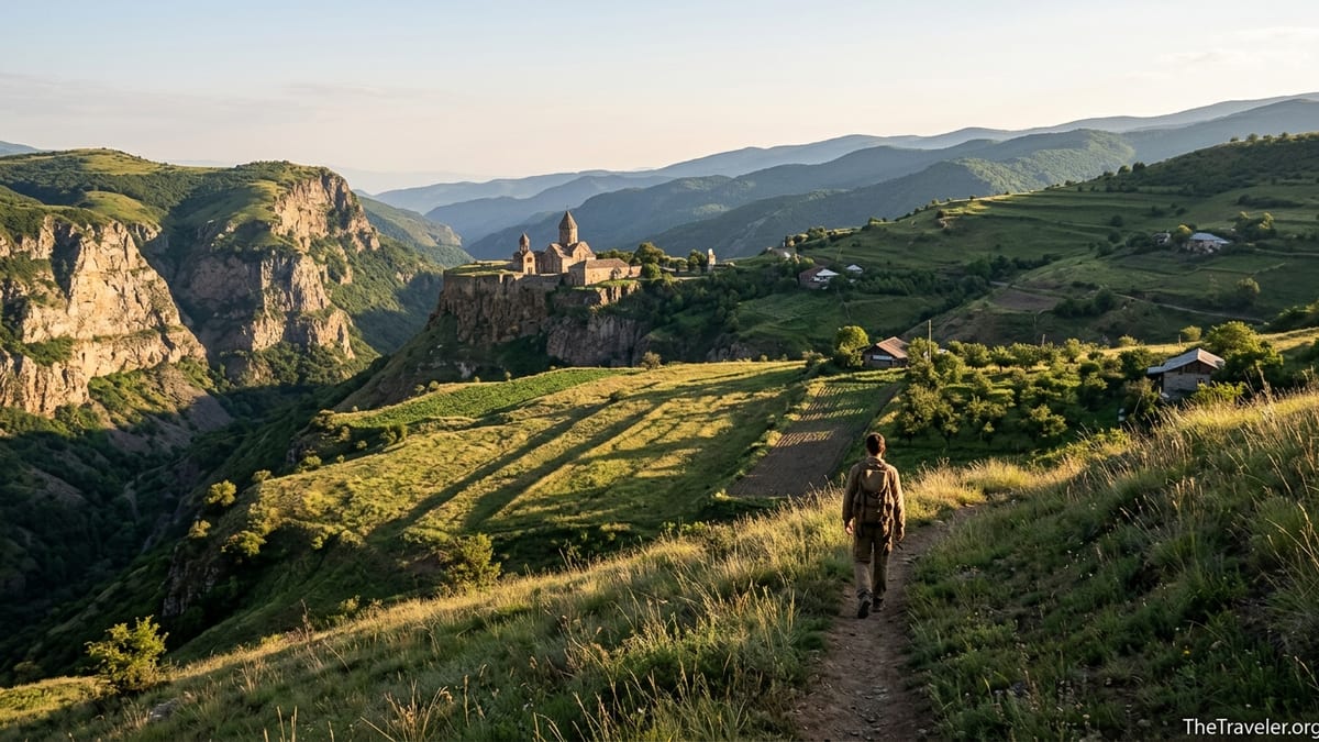
The climax of many southern itineraries is Tatev Monastery, sitting on the edge of a limestone plateau above the Vorotan Gorge. Most visitors arrive via the Wings of Tatev aerial tramway from Halidzor, a spectacular ride that claims records for length and height. Walking into Tatev on one of the footpaths that climb from the gorge bottom offers a slower, more tactile encounter. The monastery reveals itself through sound first, with the murmur of voices and the tolling of bells, then visually as you crest the final rise and see the complex, stone against sky, with the gorge dropping away beside it. At that moment, the Caucasus no longer feels like a frontier line on a geopolitical map. It feels like a place where people have learned, over centuries, to hold ground at the edge of an abyss.
People of the Trail: Hospitality and the Stories Between Borders
Before I walked in Armenia, I thought of the Caucasus primarily in terms of nationality and conflict: Armenian, Georgian, Azerbaijani; war, ceasefire, negotiations. On the trail, conversations shifted the axis to something more immediate. Guesthouse owners in Dilijan talked not about borders, but about the first foreign hikers they hosted, many of whom had come to Armenia after trekking in Georgia’s Svaneti or Tusheti regions. Farmers in Lori mentioned relatives working in Russia, while teachers in Syunik described pupils who moved between Armenia and France. The Caucasus revealed itself less as a set of separate nation‑states and more as a web of movements and relationships, some constrained by politics, others surprisingly fluid.
Marshrutka rides became informal seminars in regional geography. On the way from Yerevan to Goris, passengers debated the fastest route to Tbilisi, comparing overnight trains with minibuses that crossed the Debed Canyon. Tickets on these long‑distance marshrutkas were still priced in Armenian dram, but the conversation switched effortlessly between dram, Georgian lari and euros, reflecting lives lived partly abroad. Walking in and out of these towns, I realized that the mountains connect as much as they divide: people cross them for work, study, trade, and, increasingly, tourism.
One evening in the village of Tandzaver, after a day on the trail, my host pointed out a distant ridge and explained that beyond it lay Artsakh, known internationally as Nagorno‑Karabakh, a region that has seen severe conflict and displacement in recent years. The border was closed, the political situation tense, but her story focused on family: cousins who had once lived there, friends who had moved to Yerevan, the loss of familiar landscapes. It was a reminder that the Caucasus, experienced up close, is not defined solely by lines on a map or communiqués from foreign ministries. For the people who live here, it is a patchwork of home regions, each with its own hills, accents, and dishes.
The presence of hikers in this context is delicate. Walking connects you to local life in ways that a quick city break cannot, but it also raises questions about impact. In popular spots, prices have edged up in recent years, and there are valid concerns about over‑tourism in fragile areas. Yet in much of rural Armenia, the arrival of even a few trekkers a week can make the difference between a village shop staying open or closing for good. The challenge, increasingly discussed by local trail organizations and community leaders, is to channel the growing international interest in the Transcaucasian Trail into forms of tourism that are small‑scale, locally owned, and seasonally balanced.
Practical Realities: Costs, Safety and Seasonality
Walking across Armenia is not only a romantic idea; it is a practical travel project that, for many visitors, is more affordable than long‑distance hiking in Western Europe or North America. Daily budgets vary widely, but hikers who camp some nights and stay in simple guesthouses on others often report average expenses in the range of 20 to 25 US dollars per day, covering food, accommodation, and local transport. A sit‑down restaurant meal in a provincial town might cost around five to ten dollars, depending on the setting, while a picnic lunch of flatbread, cheese, tomatoes and fruit from a roadside stall can be assembled for much less.
Public transport is the backbone of most itineraries. Marshrutkas connect Yerevan with regional centers such as Dilijan, Vanadzor, Goris and Kapan. Schedules can change seasonally and are not always published in English, so travelers usually confirm departure times the day before by visiting the station or asking at their guesthouse. Tickets are typically paid in cash on board, and luggage is accommodated wherever space allows. Within trail towns, short taxi rides to outlying trailheads remain relatively inexpensive by international standards, though prices can climb in remote areas where vehicles are scarce and fuel must be trucked in.
Safety is an understandable concern for anyone whose impressions of the Caucasus come from news reports. In practice, most of Armenia’s established trekking regions are considered safe for visitors who follow local advice and stay updated on current conditions. Sensitive border zones exist, particularly along parts of the frontier with Azerbaijan, and hikers are advised to use verified GPS tracks, waymarked routes, and information from local organizations or guiding companies to avoid restricted areas. The political situation in the wider region can change, but inside Armenia, day‑to‑day life in cities and villages has a calm, ordinary rhythm that quickly undermines the image of a permanently volatile borderland.
Seasonality shapes the walking experience. Spring and early summer bring lush greenery to Dilijan’s forests and wildflowers to Lori’s meadows, but also more frequent rain showers and muddy trails. July and August can be hot at lower elevations, making early starts and longer rest breaks advisable, while higher sections remain comfortably cool. Autumn is, for many, the ideal time, with forests turning gold and red, grape harvests underway in wine regions like Areni, and cooler air in the canyons of Syunik. Winter brings snow to much of the country’s uplands, closing many routes to all but experienced backcountry travelers with appropriate equipment.
How Armenia Reframed the Caucasus
By the time I returned to Yerevan at the end of my walk, the Caucasus had shed its old mental labels. What stayed with me were not the abstract categories of “South” and “North” Caucasus, nor the headlines about power politics, but small, walk‑sized details: the taste of spring water at a roadside shrine in Tavush; the sight of a distant herd moving like white foam across a dark green hillside; the smell of freshly baked lavash rising from a village bakery at dawn. Armenia had not simplified the region for me. If anything, it made it more complex. But it also made it more coherent, revealing how landscapes, languages, and livelihoods mesh together across what maps present as sharp divides.
Walking forced a more honest appreciation of scale. Distances that look trivial on a screen become significant when you measure them in hours under a hot sun, or in the number of times you refill a water bottle at a village tap. Climbing from the floor of Vorotan Gorge up to Tatev’s plateau in the heat of the afternoon erases the assumption that the Caucasus is a single, uniform barrier. Instead, it becomes a series of very specific challenges, each with its own demands on the body and mind. That, in turn, changes how you read the history of the region, from the routes of armies and traders to the placement of monasteries and fortresses on defensible heights.
Perhaps the most significant shift was emotional. Before I walked in Armenia, the Caucasus occupied an in‑between space in my imagination: not fully Europe, not fully Asia, not quite Middle East. On the trail, that in‑betweenness felt less like a lack and more like a strength. You can eat khorovats grilled meat in a backyard in Goris that would not be out of place in rural Iran, then drink wine from a cellar in Areni that draws on techniques older than many European appellations. You can recognize Soviet architecture in Yerevan’s suburbs and hear church bells echo through valleys that have been Christian for more than 1,500 years. Walking makes it clear that the Caucasus is its own center, not a periphery of someone else’s map.
The Takeaway
Walking through Armenia changed how I saw the Caucasus because it transformed a region I knew mostly through headlines and static maps into a lived, continuous landscape. Long days on the Transcaucasian Trail linked forests, canyons, wine villages and cliff‑top monasteries into a single narrative that no short city break could provide. The experience grounded grand concepts such as “crossroads of civilizations” in concrete encounters: shared tea with shepherds in Vayots Dzor, conversations with guesthouse owners in Dilijan, quiet evenings watching the light shift on the rock formations above Goris.
For travelers considering a journey to the Caucasus, Armenia offers a practical and compelling entry point. The country’s growing trail network, relatively low costs, and high levels of everyday safety make it accessible, while its layered history and varied landscapes ensure that no two days on foot feel the same. Walking here will not give you the whole Caucasus. Georgia and Azerbaijan, with their own mountains and stories, remain essential parts of the wider picture. But a traverse of Armenia will challenge assumptions, complicate simple narratives, and leave you with a sense that this region is far more than a line between continents. It is a place best understood at walking speed.
FAQ
Q1. Is Armenia safe for hiking and independent travel?
Armenia’s main hiking regions, including Dilijan National Park, Vayots Dzor and Syunik, are generally considered safe for visitors who follow local advice and stay away from sensitive border areas. As with any mountain destination, conditions can change, so it is wise to check recent updates from local organizations or guides before setting out.
Q2. Do I need a visa to visit Armenia as a tourist?
Citizens of many countries, including much of Europe and North America, can currently enter Armenia visa‑free for short stays, typically up to 90 or 180 days. Rules can change, so travelers should verify the latest entry requirements with an Armenian consulate or official government source before their trip.
Q3. When is the best time of year to hike in Armenia?
Late spring, summer and early autumn are the most popular times for trekking. May and June offer green landscapes and wildflowers but more rain, July and August bring heat at lower elevations but good conditions higher up, and September and October combine stable weather with colorful autumn forests and grape harvests in wine regions.
Q4. How difficult is the Transcaucasian Trail in Armenia?
The Armenian sections of the Transcaucasian Trail include everything from moderate day hikes around Dilijan to demanding multi‑day stages in remote mountain terrain. Good fitness and previous hiking experience are recommended for longer sections, and anyone attempting a thru‑hike should be comfortable with navigation, variable weather and carrying a full pack.
Q5. What kind of budget should I plan for a hiking trip in Armenia?
Costs vary by style of travel, but many hikers find that a daily budget in the range of 20 to 40 US dollars per person covers simple guesthouses, local meals, and public transport. Camping, cooking your own food and using marshrutkas can keep expenses on the lower end of that spectrum.
Q6. Can I hike in Armenia without a guide?
Independent hiking is possible on many marked routes, especially around Dilijan and other established trekking areas, if you are experienced and comfortable with basic navigation tools. For more remote stages, or if you prefer additional security and cultural insight, hiring a local guide or joining an organized trip is a sensible option.
Q7. What should I pack for a multi‑day trek in Armenia?
Standard mountain gear applies: sturdy hiking shoes or boots, a layered clothing system for variable temperatures, rain protection, sun hat, reusable water bottles, and a first‑aid kit. For overnight trips, you will need a suitable tent or knowledge of guesthouse options, a sleeping bag rated for cool nights, and sufficient food or a plan to resupply in villages.
Q8. How do I get from Yerevan to main trail hubs like Dilijan or Goris?
Shared minibuses known as marshrutkas run regularly from Yerevan’s bus stations to towns such as Dilijan, Vanadzor, Goris and Kapan. Tickets are purchased in cash, usually directly from the driver, and fares are modest by international standards. Private taxis or transfers can also be arranged for more flexibility, especially if you are carrying bulky gear.
Q9. Are there accommodation options along the trails, or do I have to camp?
In many regions, especially around Dilijan, Lori, Vayots Dzor and parts of Syunik, small guesthouses and homestays provide beds and meals within walking distance of key routes. In more remote stretches, camping remains necessary. A mixed approach, using guesthouses when available and camping elsewhere, works well for most multi‑day itineraries.
Q10. How does hiking in Armenia compare to trekking in Georgia or other parts of the Caucasus?
Armenia offers a different mix of landscapes and culture than neighboring Georgia, with more semi‑arid canyons, fewer glaciated peaks, and a dense layer of historic monasteries and villages along the routes. Trails are developing quickly but still feel quieter and less commercialized than some Georgian hotspots, making Armenia an appealing choice for hikers who value a sense of discovery.