
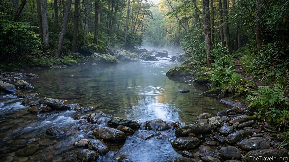
Abrams Creek is one of those Smokies waterways that locals speak of in almost hushed tones: a clear, spring-fed creek that winds from Cades Cove to Chilhowee Lake, offering exceptional trout fishing, quiet riverside camps, and stretches of wild water that feel far removed from the park’s crowds. Whether you are coming for wild rainbows, a shady swimming hole, or a secluded backroad drive with mountain views, Abrams Creek rewards travelers who are willing to look beyond the usual overlooks.
Get the latest updates straight to your inbox!
Getting Oriented: Where Abrams Creek Flows and How to Reach It
Abrams Creek runs for roughly 28 miles through Blount County in eastern Tennessee, starting in the open meadows of Cades Cove and eventually emptying into the Little Tennessee River at Chilhowee Lake. Much of its course lies inside Great Smoky Mountains National Park, but unlike the busy Sugarlands or Newfound Gap corridors, the Abrams Creek area sits in the park’s quieter southwestern corner. That remoteness is part of its appeal for anglers and travelers looking for a slower, more intimate Smokies experience.
Most visitors encounter Abrams Creek in one of two places. At the upper end, in Cades Cove, the creek meanders through pastureland and forest just off the Cades Cove Loop Road. Here it is a classic mountain trout stream, with riffles, runs, and plunge pools shaded by rhododendron and hemlock. At the lower end, near the Abrams Creek Campground outside Tallassee, the creek broadens into long, lazy pools suitable for both fishing and paddling before it slips quietly into Chilhowee Lake.
From Knoxville, reaching Cades Cove and its upper Abrams Creek access points typically takes about 1.5 hours by car, following US 129 or TN 73 to Townsend and then Laurel Creek Road into the park. To reach the more secluded Abrams Creek Campground area, drivers usually continue past Townsend and turn onto Happy Valley Road, then follow Abrams Creek Road deep into the park’s southwestern corner. The final miles are narrow and winding, and cell service is sparse, so it is worth downloading maps before you leave town.
Because the creek flows through both frontcountry and backcountry segments of Great Smoky Mountains National Park, access can feel very different depending on where you go. Upper reaches near Cades Cove are easy to reach from roadside pullouts and an established waterfall trail, while lower reaches around the campground are quieter and feel more like a traditional backcountry destination despite having a small developed campground beside the water.
Fishing Abrams Creek: What to Expect on the Water
Abrams Creek is best known among anglers for its wild rainbow trout, which thrive in the creek’s cold, limestone-influenced water. Experienced Smokies anglers often compare the upper creek around Cades Cove to well-known spring creeks in Pennsylvania: clear water, rich aquatic life, and selective trout that reward careful presentations. This is not a place for stocking-truck fishing; you are targeting wild fish that have survived floods, droughts, and heavy pressure in a popular national park.
Seasons on Abrams Creek follow typical Smokies patterns, with prime trout fishing usually running from early April through May and again in September and October when water temperatures are comfortable and insect hatches are more consistent. Anglers who visit in midsummer still find fish, but often restrict their efforts to early morning and late evening to avoid warm water and bright sun. In winter, water levels can be low and clear, demanding finer tippet and smaller flies.
Fishing regulations in Great Smoky Mountains National Park are generally more permissive than many realize but still tightly defined. A valid Tennessee or North Carolina fishing license is required, and bait fishing is prohibited throughout the park; only artificial lures or flies may be used. Daily trout creel limits and minimum sizes apply, and certain sections of Abrams Creek, especially below Abrams Falls, have historically been closed or tightly managed to protect threatened fish species. Before a trip, travelers should confirm current regulations and area closures through park information channels and not rely on old guidebooks.
In practice, a visiting angler might base at a cabin in Townsend, purchase a short-term Tennessee nonresident license from a local outfitter, then spend a full day sampling Abrams Creek. Morning might be devoted to pocket-water fishing above the falls, followed by an afternoon session in the longer, deeper pools closer to the campground. Many anglers carry both a shorter 7.5 to 8.5 foot 3-weight or 4-weight fly rod for tight cover in the upper creek and a slightly longer 9-foot rod for reaching wary trout in the flatter lower reaches.
Upper Abrams Creek and Cades Cove: Easy Access and Classic Smokies Scenery
For most general visitors, the most convenient way to experience Abrams Creek is from the Cades Cove Loop Road. Here, the stream threads the open valley floor, with classic Smokies scenery: historic log cabins, split-rail fences, and white-tailed deer grazing within sight of the water. Several pullouts near the loop road provide short walks to the creek, making this an easy stop even for families with small children or travelers tight on time.
A standout experience on upper Abrams Creek is the hike to Abrams Falls. The Abrams Falls Trail begins near the far end of the Cades Cove Loop and follows the creek for about 2.5 miles each way, with the sound of water never far from the path. Along the trail, anglers often drop to accessible pools where regulations allow, while sightseers enjoy rock outcrops, rhododendron tunnels, and occasional glimpses of the creek rushing through tight bends. The trail is popular, but starting early in the morning usually offers cooler temperatures and fewer people.
The falls themselves are only about 25 feet high, but the volume of water pouring over the sandstone ledge into a deep, turquoise pool makes this one of the Smokies’ most photogenic spots. While it is a tempting swimming hole, currents can be much stronger than they appear and the park has posted repeated warnings about drownings here. Travelers are better off taking in the scene from the boulders at the water’s edge and reserving their swimming for safer, slower stretches downstream.
Because of the combination of scenic value and ease of access, upper Abrams Creek works well for mixed groups where not everyone is focused on fishing. One traveler might spend a couple of hours casting dry flies to rising trout in a shaded run, while others walk the loop road to photograph historic churches or look for black bears in the open fields. The ability to regroup easily at pullouts or picnic areas makes this section of the creek especially practical for multi-generational trips.
The Abrams Creek Campground Area: Secluded Basecamp on the Water
At the opposite end of the watershed, the Abrams Creek Campground offers a very different experience. With only 16 campsites and no hookups or showers, this small frontcountry campground feels more like a backcountry outpost than a typical park campground. Most sites sit within earshot of the creek, and a few offer filtered water views through the trees, so you fall asleep to the sound of moving water rather than highway traffic.
The campground generally operates on a seasonal schedule, opening in late spring and closing in fall, though exact dates can shift depending on weather and park operations. All sites are reservable rather than first-come, first-served, which means travelers planning a peak summer weekend or fall foliage trip should secure a spot several weeks in advance through national reservation channels. Prices are typically in line with other frontcountry Smokies campgrounds, which makes this one of the more budget-friendly ways to spend several days on Abrams Creek.
From the campground, short informal paths lead down to gravel bars, boulder outcrops, and bend pools where anglers can start fishing within minutes of stepping out of their tents. Early risers often have the water to themselves, working nymphs and small streamers through deep slots before the light hits the canyon walls. Paddlers sometimes launch small kayaks or packrafts in the calmer sections near the campground, though water levels vary and logs or strainers can present hazards that demand caution.
Because this corner of the park is so quiet, it is worth treating the campground as a base for exploration rather than a single-night stop. A typical three-day itinerary might include one day of focused fishing near the campground and along nearby trail-accessible segments of the creek, another day hiking one of the linking trails up toward Cades Cove, and a final day reserved for simple river time: reading on the gravel bars, photographing morning fog hanging in the trees, and watching for kingfishers and mergansers working the runs.
Hidden Beauty: Horseshoe Bend, Side Trails, and Quiet Corners
Beyond the well-known sections near Cades Cove and the campground, Abrams Creek holds some truly hidden stretches that are legendary among serious anglers and hikers. One of the most famous is the so-called Horseshoe, a deep loop of the creek between trail access points that forms an extended canyon-like segment. In this stretch, the creek drops through boulder gardens and plunge pools far removed from any road. The fishing can be exceptional, but the route involves long hours of wet wading and scrambling and is not recommended for casual visitors or anyone unfamiliar with Smokies backcountry.
Safer, more accessible “hidden corners” can be found along side trails in the Abrams Creek region. The Little Bottoms Trail, for example, leaves from near the campground area and parallels the creek for sections, offering occasional steep side paths down to quiet pools where you might see no one else all day. Farther up, or by linking with routes like the Cooper Road or Hatcher Mountain trails, hikers can reach higher-gradient segments where the creek feels more like a mountain stream than a lowland river.
These lesser-known access points reward travelers who do a bit of research and are willing to hike beyond the first scenic overlook. It is not unusual to start on a trail that feels busy near the trailhead and, within an hour, find yourself alone with only the sound of the creek and the occasional splash of a rising trout. Photography-minded visitors will appreciate how the canyon walls and dense forest create pockets of soft, reflected light, ideal for capturing details like mossy boulders, eddies curling around logs, or late-season wildflowers along the banks.
Because many of these spots lack formal overlooks, safety and Leave No Trace principles are critical. Anglers and photographers should resist the temptation to create new social trails, instead using existing paths and durable surfaces to reach the water. The geology of the Abrams Creek corridor includes slick bedrock and undercut banks, especially after rain, so moving slowly and testing each step is part of the experience, particularly in remote sections with no quick exit to a road.
Practical Tips: Licenses, Gear, Timing, and Safety
Planning a successful visit to Abrams Creek starts with a few practical steps. Anyone 13 or older who intends to fish will need a valid state fishing license; for most travelers, that means purchasing a Tennessee nonresident license, often available in nearby gateway towns such as Townsend or Maryville. Great Smoky Mountains National Park does not require a separate fishing permit, but anglers must carry their state license on the water and be ready to show it to rangers.
Gear choices depend heavily on your goals. For wading anglers, breathable chest waders and wading boots with good traction are useful in cooler months and during high water, while in summer many locals wet wade in quick-drying pants and wading shoes. A small chest pack or sling with room for a fly box, forceps, tippet, and a compact water filter is generally sufficient. Hikers and sightseers should pack as they would for any Smokies outing: a light rain shell, snacks, at least a liter of water per person, and paper or downloaded maps since cell coverage is unreliable around the creek.
Timing also makes a big difference in how Abrams Creek feels. Weekdays generally see fewer visitors than weekends, and early morning or late afternoon light enhances the creek’s sense of enclosure and quiet, especially near the campground. Spring wildflower season from April into early May offers lush banks and moderate temperatures, while October brings color in the surrounding hardwoods and a crisp clarity to the water. High summer often means warm air, afternoon thunderstorms, and heavier traffic on roads leading to Cades Cove.
Safety considerations are straightforward but important. Thunderstorms can raise water levels quickly, especially in the narrower canyon sections and in the Horseshoe, so visitors should always have an exit plan that does not depend on crossing the creek at a single point. Rocks are slick, and currents can be deceptively strong even in small drops or narrows. It is wise to let someone outside your group know your plans for the day, including trailheads and approximate return times, particularly if you intend to explore beyond the most popular overlooks or to fish remote pools where you might not see other hikers at all.
Wildlife, Conservation, and Respecting a Complex Ecosystem
Like much of Great Smoky Mountains National Park, Abrams Creek has a complicated ecological history. In the late 1950s, parts of the creek were chemically treated in an attempt to create a more favorable environment for rainbow trout, a move that dramatically reduced native fish diversity. Since then, biologists have worked to reintroduce and protect several rare and threatened species, including small native fishes that most visitors never see but that form the backbone of the creek’s food web.
For today’s traveler, that history makes respect and restraint especially important. Catch-and-release ethics are widely practiced on Abrams Creek, even in sections where harvest is technically allowed, as anglers aim to preserve wild trout populations and reduce pressure on sensitive habitats. Using barbless hooks, handling fish with wet hands, and releasing them quickly back into oxygenated water are simple steps that help keep the fishery healthy.
Beyond the fish themselves, the creek corridor is home to kingfishers, herons, mergansers, otters, and an array of amphibians that depend on clean, cool water. Trout anglers often spot waterthrushes flitting along the banks, while patient observers in the quieter pools near the campground may see small schools of minnows and darters hovering in the current. Black bears and white-tailed deer move the slopes above the creek, particularly in the early morning and late evening, and standard Smokies food-storage rules apply around both the campground and any backcountry campsites.
Given these sensitivities, visitors should pack out all trash, avoid moving rocks or logs that form microhabitats in the stream, and stay on established trails whenever possible. Even simple choices, like camping only in designated sites and keeping noise levels low along the water, contribute to a healthier ecosystem and preserve the sense of quiet that draws people to Abrams Creek in the first place.
The Takeaway
Abrams Creek is not the loud, postcard-famous waterfall or roadside overlook that appears on every Smokies brochure. Instead, it is a long, intricate ribbon of water that invites repeat visits and slower exploration. From the easy-access pools and waterfall trail near Cades Cove to the hushed campsites of Abrams Creek Campground and the remote bends reachable only by trail, the creek offers a spectrum of experiences that can fill a quick half-day stop or a week-long fishing and hiking trip.
For anglers, Abrams Creek is an opportunity to match wits with wild trout in a setting rich with both challenge and reward. For sightseers and families, it is a quieter alternative to the park’s busiest corridors, with shady banks, photogenic cascades, and a real sense of being away from it all though still within reach of services in Townsend and Maryville. For everyone, it is a reminder that some of the Smokies’ finest scenery is found not at the biggest overlooks, but down along the water, where every bend in the creek hides another riffle, another pool, and another moment of unexpected beauty.
FAQ
Q1. Do I need a special permit to fish Abrams Creek in Great Smoky Mountains National Park?
A state fishing license from Tennessee or North Carolina is required to fish Abrams Creek inside the park, but the park itself does not issue a separate fishing permit. Anglers must follow park-wide regulations on gear and harvest, which generally require artificial lures or flies and set daily trout limits; rules can change, so always check current guidance before your trip.
Q2. What kinds of fish can I expect to catch in Abrams Creek?
The upper and mid reaches of Abrams Creek are best known for wild rainbow trout, with some brown trout present in certain sections. Closer to its confluence with Chilhowee Lake, the creek transitions into more of a mixed fishery where anglers may also encounter smallmouth bass and various panfish species, though trout are still the main draw for most visitors.
Q3. When is the best time of year to visit Abrams Creek for fishing?
Spring and fall are generally considered the prime seasons for fishing Abrams Creek. From April through May and again in September and October, water temperatures are typically favorable for trout activity, insect hatches are more predictable, and air temperatures are comfortable for hiking and wading. Summer can still be productive at dawn and dusk, while winter fishing requires more technical tactics in cold, clear water.
Q4. Is Abrams Creek Campground suitable for RVs?
Abrams Creek Campground is a small, rustic campground without hookups or dump stations, and sites are better suited to tents and small camper vans than to large RVs. The access road is narrow and winding, and there are no pull-through sites, so larger rigs may find maneuvering difficult. Travelers with compact setups who value quiet and proximity to the water, however, often find it an ideal base for exploring the creek.
Q5. How difficult is the hike to Abrams Falls along Abrams Creek?
The Abrams Falls Trail is about 5 miles round trip with moderate elevation changes and some rocky, rooty sections that can be slippery when wet. Most reasonably fit hikers can complete it in three hours or so, not counting time spent at the falls. Good footwear, water, and an early start are recommended, especially in warm weather or on busy weekends when parking pressures are higher.
Q6. Are there safe places to swim in Abrams Creek?
Abrams Creek includes several calmer pools and gravel bars, especially near the campground and in some lower-gradient sections, where visitors sometimes wade or cool off. However, the park has repeatedly warned that swimming directly at the base of Abrams Falls is dangerous due to strong currents and hidden hazards. Anyone entering the water should choose slow, shallow stretches, avoid high water after storms, and never dive into unfamiliar pools.
Q7. Can I access Abrams Creek by kayak or canoe?
Paddlers occasionally explore sections of Abrams Creek, particularly the slower water near the campground and the embayment where the creek meets Chilhowee Lake. That said, water levels, downed trees, and strainers can make navigation challenging, and this is not a regularly managed whitewater run. Those who do paddle should have solid moving-water skills, scout carefully, and be prepared to portage around obstacles.
Q8. Is Abrams Creek a good destination for families with children?
Yes, especially the sections near Cades Cove and the more accessible areas around Abrams Creek Campground. Families often enjoy short walks from roadside pullouts, picnics on gravel bars, and wildlife watching along the creek. Parents should keep a close eye on children near moving water, choose gentle banks rather than steep drop-offs, and be aware that cell service is limited, so advance planning and clear meeting points are helpful.
Q9. What kind of camera gear works best for photographing Abrams Creek?
Photographers will find a wide-angle lens ideal for capturing creek curves, waterfalls, and surrounding forest, while a short telephoto works well for isolating cascades or wildlife along the banks. A lightweight tripod or stabilizing device helps in low light under the tree canopy, especially for long exposures that blur the water. Polarizing filters are useful for cutting glare on the water’s surface and revealing rock textures and submerged leaves.
Q10. How can I help protect Abrams Creek while visiting?
Visitors can support the health of Abrams Creek by following Leave No Trace principles: packing out all trash, staying on established trails, camping only in designated sites, and minimizing disturbances to rocks, logs, and vegetation along the banks. Anglers can further reduce their impact by practicing catch and release with barbless hooks, handling fish gently, and avoiding fishing in very warm water when trout are more stressed. Respectful behavior today helps ensure that the creek’s wild character endures for future travelers.