
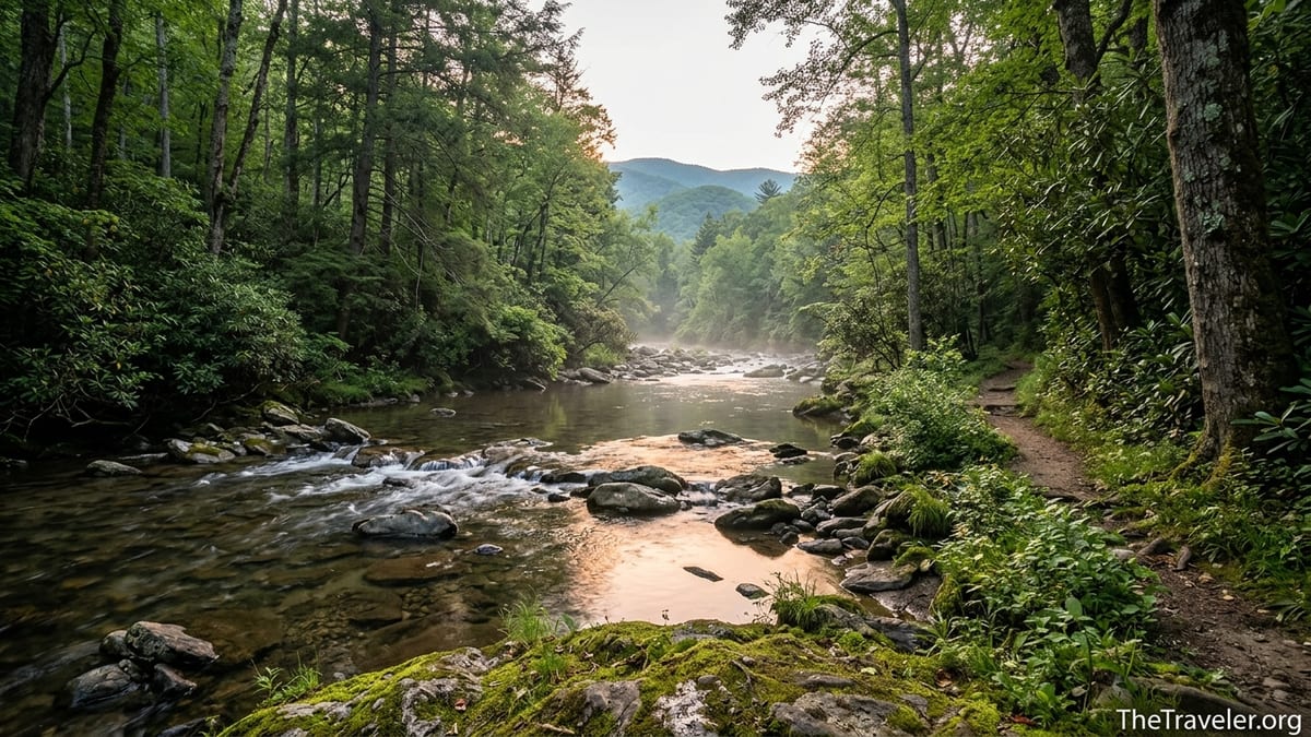
The first surprise at Abrams Creek is the quiet. After the brake-light parade of Cades Cove and the craft stores of Gatlinburg, the soundscape here shrinks to one simple rhythm: water folding over rocks. The road narrows, cell service drops away, and suddenly the busiest national park in the United States feels almost private. Following Abrams Creek, you discover a pocket of Great Smoky Mountains National Park that moves at a different pace, where a handful of campsites and little-used trails offer an escape from the park’s crowded main corridors.
Get the latest updates straight to your inbox!
Finding the Quieter Side of the Smokies
Abrams Creek sits on the far western flank of Great Smoky Mountains National Park, reached by a narrow road that peels off the well-traveled routes to Townsend and the Foothills Parkway. Instead of tour buses and souvenir shops, you pass farm fields, rural churches, and mailboxes with faded paint. It feels more like you are visiting a local back road than approaching one of the most visited parks in the country.
The contrast with Cades Cove is immediate. On a busy summer Saturday, the 11-mile Cades Cove Loop Road can crawl along at walking speed, with drivers leaning out windows to photograph every deer in the field. At Abrams Creek, you may see only a couple of cars in the small parking areas by midday. Rangers and long-time visitors often describe this side as “lightly used” compared with the major gateways, and that difference shapes everything from how you plan your day to how you experience the forest.
For many travelers, this makes Abrams Creek a strategic second- or third-day destination. After a first day ticking off marquee sights like Clingmans Dome or Laurel Falls, they come here for something more elemental: the feeling of a creek slipping through a narrow valley, the scent of rhododendron leaves warming in the sun, and the rare privilege of walking a Smokies trail without a line of people in front and behind.
The isolation is not absolute; this is still a national park. But following Abrams Creek gives you a rare sense that you have stepped behind the scenes of the Smokies, into the quiet corridors where the park breathes.
Getting to Abrams Creek Without Losing Your Nerve
Reaching Abrams Creek from Knoxville or Maryville is straightforward on a map but feels deliberately off the grid. Drivers usually leave the main highways near mile marker 14 on U.S. 129, turning onto Happy Valley Road. The pavement narrows, curves sharpen, and the last stretch along Abrams Creek Road passes the small ranger station before ending at the campground and trailheads. It is paved the entire way, but you will want to drive slowly and be prepared for local traffic and the occasional deer stepping from the trees.
Compared with the well-signed approach to Gatlinburg or the multi-lane roads leading toward Pigeon Forge, the approach to Abrams Creek feels almost unmarked. There are modest wooden park signs and a simple turn to the ranger station, not the long lines of cars queued at a formal entrance station. In practice this means you should download maps or mark your route before you leave town. Cell coverage often fades before you reach Happy Valley Road, and relying on live navigation here can be risky.
Parking is limited but usually sufficient given the low visitation. A small asphalt lot near the campground serves hikers heading for the Cooper Road, Rabbit Creek, Little Bottoms and Abrams Creek trails. On busy October weekends, when fall color draws more people into every corner of the park, you might have to be flexible about your start time or trail choice. On a typical midweek morning, though, you can arrive at 9 a.m. and still have your pick of spaces.
The road’s remoteness is part of its appeal, but it has practical implications. You will not find coffee kiosks or outdoor gear shops five minutes from the trailhead. Fuel up in Maryville or Townsend, pack a full day’s worth of water and food, and carry basic tools like a tire repair kit. Many visitors treat the last grocery stop as the Food City or Walmart in Maryville, where you can pick up ice, cooler supplies and inexpensive camp chairs before civilization falls away behind you.
Life at Abrams Creek Campground
Abrams Creek Campground is tiny by Smokies standards, with just 16 sites tucked between the creek and a low wooded ridge. The National Park Service lists the season for 2026 as roughly early May to late October, with specific dates adjusted year to year, and a nightly fee around 30 dollars for each frontcountry site. Compared with the 159 sites at Elkmont or 159 at Smokemont, this little loop feels almost like a private camp for those who make the effort.
The sites themselves are simple. Expect a flat gravel pad, a metal fire ring with a cooking grate, a picnic table and nearby access to restrooms with flush toilets but no showers. There are no electrical hookups and no dump station. Official information notes that maximum RV length here is short, around 12 feet, reflecting how tight the loop road and parking aprons are. In practice that means this campground caters to tent campers, car campers, and owners of very small vans or compact trailers rather than big rigs.
What you gain in simplicity you gain back in setting. Several sites sit close enough to Abrams Creek that you fall asleep to water noise rather than highway hum. In early June, fireflies wink in the understory and barred owls call across the valley. On a midweek July night, you might share the entire loop with only a handful of other parties: a couple from Atlanta reading by headlamp, a father and son practicing fly casts in a quiet pool at dusk, a pair of backpackers staging for an early start on the Rabbit Creek Trail.
Reservations are required and made in advance through the park’s booking system, similar to other frontcountry campgrounds. Because of the low site count, weekends in peak season can still book up, but the competition is nothing like the frenzy for riverfront sites at Elkmont or holiday weekends at Cades Cove. If you are flexible and can travel Sunday through Thursday, it is often possible to find a site within a week or two of your visit.
Following the Creek: Trails That Trade Crowds for Solitude
Most visitors know Abrams Creek as the river that feeds Abrams Falls, one of the park’s most popular waterfall hikes starting from Cades Cove. Few realize that you can also follow this same creek from the opposite direction, starting near Abrams Creek Campground. On this side the water feels more intimate, the banks narrower, and the human presence far lighter.
The Little Bottoms and Abrams Creek trails trace the river’s bends, alternating between soft, shaded forest and abrupt openings where the creek widens into deep green pools. Unlike the well-graded tourist paths closer to Gatlinburg, these are classic Smokies trails: roots, rocks, occasional muddy stretches, and several streamside sections that may be slick after rain. Hikers who are used to the busy Abrams Falls Trail from Cades Cove are often surprised at how few people they meet here, even on a sunny Saturday in May.
Cooper Road Trail offers a different experience. Once a historic route connecting communities, it now begins near the campground as a gently climbing forest road turned trail. Because it does not end at a waterfall or viewpoint that draws Instagram crowds, it remains overlooked. This makes it an excellent choice for travelers seeking an easy to moderate walk in the woods where bird calls, not conversation, dominate the soundscape. In late spring, the understory here glows with mountain laurel blooms and fresh green leaves, and you can walk for an hour without seeing another party.
More committed hikers use Abrams Creek as a gateway to deep-park loops. A common route links Cooper Road, Rabbit Creek and Hannah Mountain into day hikes of 10 to 15 miles, with long sections where you may see only bear tracks and the occasional backpacker. If you attempt these, carry a detailed map, plenty of water, and a realistic estimate of your pace. Trail reports describe sections with creek crossings and uneven footing that become significantly more challenging after heavy rain.
A Day That Feels Like an Escape
Designing a day at Abrams Creek is less about chasing a single landmark and more about stepping into a slower rhythm. One realistic itinerary starts with a dawn departure from Townsend, a 45-minute drive that sees you turning onto Happy Valley Road just as early light hits the ridges. By 8 a.m. you have parked near the campground, tightened your daypack straps, and stepped onto Cooper Road Trail while the creek mumbles through the rhododendron to your right.
By midmorning, you might be wandering down the Little Bottoms Trail, pausing to watch a kingfisher arrow upstream or to photograph the way sunlight filters through hemlock branches onto the water. Instead of jockeying for space at a crowded viewpoint, you drop onto a smooth boulder and share a mid-hike snack of trail mix and sliced apples with no audience but the water striders in the shallows. You may pass one or two other hikers, perhaps locals who know this corner well and nod hello without breaking stride.
Afternoon heat can be intense in July and August, but the creek offers both visual and literal refreshment. There are several shallow gravel bars where you can slip off your boots and soak tired feet while small fish investigate your toes. Importantly, swimming in the deeper pools requires caution: the park warns that cold water, strong currents and slick rocks make many mountain streams hazardous, and drownings have occurred in the Abrams Creek system. Most visitors content themselves with wading in calf-deep eddies, splashing kids where the current is gentle, and leaving full immersion to experienced swimmers who understand the risks.
As the day cools, you can wander back to the campground, cook a simple dinner over the fire ring and watch dusk move down the valley. The sky darkens in layers, from cobalt above the ridge to a deep green-black over the creek, and the only artificial light comes from your lantern and the occasional passing headlamp on the trail. It is a very different end to the day than a neon-lit stroll down Gatlinburg’s main strip, and that contrast is exactly why many people come.
Why Abrams Creek Feels So Different From Cades Cove
On paper, Abrams Creek and Cades Cove are closely linked. The cove’s broad meadows drain into Abrams Creek, which then winds west to meet the Little Tennessee River. Hikers on longer routes can even walk from Cades Cove to the Abrams Creek area via connecting trails that cross the park’s interior ridges. Yet the two places feel worlds apart because of how people move through them.
Cades Cove has become the Smokies’ signature drive. On a peak summer afternoon the loop road can host hundreds of vehicles at once, including rental cars, motorcycles, and motor coaches. Parking areas near popular trailheads like Abrams Falls, Gregory Bald and the Cable Mill historic district fill early, and visitors sometimes queue for parking spots or wait as wildlife jams form around a single black bear in a distant field.
Abrams Creek, by contrast, is shaped by its dead-end road and lack of marquee roadside attractions. There is no one overlook that everyone feels compelled to see, no paved path to a famous waterfall. That reality filters out casual traffic and rewards those who are comfortable trading roadside convenience for a more traditional hiking-focused experience. People who end up here tend to be campers, anglers, and hikers who are happy to follow a creek simply for the pleasure of its company.
For travelers, this difference has a clear practical benefit. If your schedule includes a day in Cades Cove to experience the historic cabins and sweeping valley views, balancing it with a day at Abrams Creek can restore a sense of wildness that might otherwise be lost in traffic. Many repeat visitors learn to alternate: one day in a marquee area such as Newfound Gap or Clingmans Dome, followed by a day in a quieter corner like Abrams Creek, Big Creek or Greenbrier.
Planning Essentials: Seasons, Safety and Expectations
Weather and seasonal schedules shape any trip to Abrams Creek. The campground typically opens in early May and closes in late October, with exact dates adjusted annually. Spring brings cool nights that can drop into the 40s Fahrenheit at this elevation, even when nearby towns stay warmer. Early-season visitors often pack a warmer sleeping bag and a beanie for sitting around the fire. By July, daytime highs in the valley can climb into the 80s or low 90s, but shaded trails along the creek remain noticeably cooler than exposed roads or meadows.
In autumn, usually from late September into late October, the hardwood forests around Abrams Creek stage a quieter version of the park’s famed leaf show. While Newfound Gap Road can host stop-and-go lines of cars at peak color, this side valley tends to see more moderate visitation. Campsites may still book up on peak weekends, so reserving at least several weeks ahead is wise if you are targeting prime foliage.
Safety here revolves around three main factors: water, wildlife and remoteness. Abrams Creek’s currents can be deceptively strong, and wet rocks are extremely slick. The park’s accident history includes drownings in the Abrams system, especially near waterfalls and deep pools. Parents should keep children close when near the water’s edge, and adults should avoid climbing on wet boulders or logs. Black bears roam this area as they do throughout the park; food storage regulations apply, and campers use provided food storage options or keep all scented items locked inside hard-sided vehicles.
Finally, remoteness means that help may take time to arrive if something goes wrong. There is a small ranger station near the campground, but visitors should not expect immediate response comparable to a city. Basic first-aid supplies, plenty of water, a paper map, and a realistic understanding of your group’s ability can make the difference between a small problem and a serious incident. Many hikers carry a simple whistle and a backup light source as insurance in case a day hike runs longer than expected.
The Takeaway
Following Abrams Creek is not about chasing the most famous view in Great Smoky Mountains National Park. It is about trading spectacle for intimacy: the curl of water around a stone, the rasp of a kingfisher’s call, the sight of morning mist lifting from a narrow valley where only a handful of people have stirred. In a park that now welcomes well over ten million visitors a year, corners like this feel increasingly precious.
If your image of the Smokies is shaped by tail lights on Newfound Gap Road or crowded overlooks at Clingmans Dome, a day or two at Abrams Creek can rewrite that story. Here, the national park reveals its quieter side, one where a tiny campground and a network of modest trails offer the rarest commodity in a busy landscape: room to breathe. You leave with fewer postcard photos and more memories of small, personal moments along the water.
For travelers willing to drive the extra miles, carry their own comforts, and accept a little uncertainty in exchange for space, Abrams Creek delivers a version of the Smokies that feels both wilder and more welcoming. It proves that even in one of America’s busiest parks, there are still places where the loudest sound is the creek, and the main attraction is simply the act of being there.
FAQ
Q1. How do I get to Abrams Creek from Townsend or Knoxville? From Townsend, you generally drive toward U.S. 129 and turn onto Happy Valley Road, following signs for Abrams Creek and the ranger station before continuing to the campground area. From Knoxville, many visitors reach Abrams Creek by taking U.S. 129 south toward Maryville and continuing toward the Foothills Parkway before turning onto local roads marked for Abrams Creek.
Q2. Is Abrams Creek Campground suitable for RVs and trailers? The campground has very small sites and tight turns, and the National Park Service lists a short maximum vehicle length, around 12 feet. It is best suited to tents, car campers and very small vans or compact trailers rather than larger RVs or fifth wheels.
Q3. Do I need reservations to camp at Abrams Creek? Yes. Like other frontcountry campgrounds in Great Smoky Mountains National Park, Abrams Creek uses a reservation system, and you are expected to book a site in advance through the official channels before driving to the campground.
Q4. What hiking options are available from the Abrams Creek side? Several trails begin near the campground and follow or approach the creek, including Cooper Road Trail, Little Bottoms Trail, Rabbit Creek Trail and Abrams Creek Trail itself. These can be combined into longer loop hikes or enjoyed as shorter out-and-back walks along the water.
Q5. Is it safer or easier to reach Abrams Falls from Abrams Creek instead of Cades Cove? Reaching Abrams Falls from the Abrams Creek side involves longer, more remote trails that are generally rougher and less traveled than the popular route from Cades Cove. While they offer more solitude, they are not necessarily easier or safer, and only well-prepared, experienced hikers should attempt those longer connections.
Q6. When is the best season to visit Abrams Creek? Late spring through early fall is ideal. From May into June you get cooler nights and lush greenery, summer offers warm days for creekside hiking and wading, and early to mid-autumn brings colorful foliage with fewer crowds than better-known park corridors.
Q7. Can I swim in Abrams Creek? Many visitors wade in shallow, calm sections to cool off, but swimming in deep pools or near swift current is risky. The water can be cold, currents strong, and rocks very slick, so the safest option is usually to limit yourself to shallow wading in gentle eddies.
Q8. Are there bears and other wildlife around Abrams Creek? Yes. Black bears, deer, turkey and smaller wildlife are common in this part of the park. Visitors must store food properly, follow park regulations about wildlife viewing distances, and never feed animals or leave food unattended at campsites or along trails.
Q9. Will I have cell phone service at Abrams Creek? Cell coverage is often weak or nonexistent near the campground and along the creekside trails. You should download maps ahead of time, let someone know your plans, and be prepared to navigate without relying on live phone data or GPS.
Q10. How does Abrams Creek compare to busier areas like Cades Cove or Gatlinburg? Abrams Creek is smaller, quieter and more remote, with a tiny campground, limited facilities and fewer visitors. It lacks the historic buildings and auto-loop scenery of Cades Cove or the restaurants and shops of Gatlinburg, but offers creekside trails, dark skies, and a much stronger sense of escape from crowds.