
Abrams Creek sits in a far less traveled corner of Great Smoky Mountains National Park, where a cold, limestone-fed stream bends through deep forest and low mountains before slipping quietly into Chilhowee Lake. For anglers, hikers and road-weary travelers, this out-of-the-way valley near Tallassee, Tennessee has become a refuge: a place to hear moving water instead of highway noise, to cast for wild trout far from roadside crowds, and to walk into real backcountry without committing to a punishing expedition. At a time when many Smokies trailheads feel busy from dawn onward, Abrams Creek still offers the rare commodity that more and more travelers are seeking: genuine solitude.
Get the latest updates straight to your inbox!
A Quiet Corner of America’s Busiest National Park
Abrams Creek flows west from Cades Cove to the Little Tennessee River, but the section that draws solitude seekers lies near the Abrams Creek entrance by Happy Valley Road outside the tiny community of Tallassee. Reaching it from Knoxville or Maryville typically involves a series of smaller country roads instead of the main Gatlinburg and Pigeon Forge corridors, which naturally filters out casual sightseers. You are unlikely to stumble across Abrams Creek by accident, and that remoteness is a large part of the appeal.
Within Great Smoky Mountains National Park, areas like Newfound Gap, Clingmans Dome and Laurel Falls see intense visitation. Rangers regularly report traffic backups on Newfound Gap Road and Cades Cove Loop during peak foliage and summer weekends. By contrast, the Abrams Creek entrance feels almost sleepy, particularly outside holiday periods. Travelers who have spent a morning in line at the Sugarlands Visitor Center parking lot are often surprised to find only a handful of cars at Abrams Creek trailheads on the same sunny afternoon.
The park’s own maps show only a small developed footprint here: a seasonal campground with 16 sites, a ranger station, a few trailheads and the narrow paved road that dead-ends at the creek. Beyond that point, access is on foot or by wading the stream itself. For visitors who equate “national park” with pull-off viewpoints and crowded picnic areas, Abrams Creek offers a very different model, one where the dominant sounds are moving water, wood thrush and wind in the poplars.
This quieter atmosphere does not mean visitors are completely alone. The Abrams Creek corridor still sits within one of the most visited national parks in the United States, and on fair-weather weekends in October or during a May hatch it can certainly feel lively. But even then, the level of activity is modest compared with better-known gateways like Gatlinburg or Cherokee, and it is easier to step away from the road and find a patch of forest or streambank that feels entirely your own.
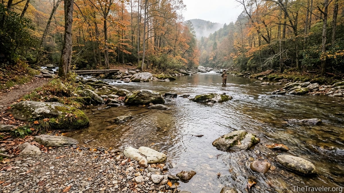
Why Anglers Travel Here for Wild Trout
Among fly fishers, Abrams Creek has an outsized reputation. Upper reaches near Cades Cove are known for producing some of the largest wild rainbow trout in the park, thanks in part to the stream’s limestone geology and rich aquatic insect life. Downstream near the Abrams Creek Campground, anglers can move between riffles, deep pools and long glides within a short walk of their campsite, targeting both trout and, farther toward Chilhowee Lake, smallmouth bass where the water slows and warms.
For visiting anglers, one of the biggest draws is how fishable the creek remains through much of the season. While some Smokies headwater streams run thin by late summer, the Abrams drainage usually keeps enough flow for skittish rainbows to hold in deep green pockets and along undercut banks. It still requires thoughtful presentation and light tippet, but the fish have room to spread out and behave like wild trout rather than clustered survivors in low water. That makes it an appealing option for anglers planning trips in May, June and again in early fall when flows and temperatures often line up well.
The solitude angle is practical as well as emotional. Because Abrams Creek sits away from the park’s main tourist strips, anglers often find that popular runs remain uncrowded even on Saturdays. A visiting fly fisher who based out of Townsend in June might drive 20 minutes to a well-known roadside river and find a dozen anglers already working visible pools. The same person who drives an extra half-hour to Abrams Creek is more likely to encounter just a couple of other anglers spread over a long stretch of water or, on some weekday mornings, no one at all. For those who like to settle into a single pool and experiment with different dry flies or nymphs without feeling pressured, that breathing room matters.
Fishing here demands respect. The stream includes sections like the so-called “Horseshoe,” where steep, slick boulder fields and fast chutes can turn a misstep into a serious injury. Local guides and experienced Smokies anglers emphasize that this is not a place to wade thoughtlessly. Yet for those who approach it with caution, a wading staff and proper footwear, the reward can be an afternoon of casting to wild trout within earshot of nothing but flowing water and distant woodpeckers, a kind of concentrated mountain calm that is increasingly rare in more accessible rivers.
Trailheads That Lead Directly Into Solitude
Hikers reach Abrams Creek mainly via a small network of interconnected trails that fan out from the campground and ranger station area. Rabbit Creek Trail, for example, climbs toward the interior of the park, linking with Hannah Mountain and Hatcher Mountain Trails. These routes do not appear in many “top ten Smokies hikes” lists, in part because they lack a singular, heavily photographed destination like Chimney Tops or Alum Cave. Instead, they offer miles of quiet forest, stream crossings and the occasional opening where you can glimpse the low profile of Chilhowee Mountain.
From the Abrams Creek end, Rabbit Creek Trail begins with a suspension bridge and follows the water before turning into the hills. Hikers who commit even a mile or two will often find themselves alone, especially outside prime foliage weeks. Backpackers use this corridor to access backcountry campsites deeper in the park, but day hikers can just as easily do out and back walks tailored to their fitness and daylight. A family staying two nights at Abrams Creek Campground might spend one morning doing a modest three hour hike up Rabbit Creek Trail, then an afternoon letting children wade and skip rocks near the bridge without ever moving their vehicle.
Another connector, Little Bottoms Trail, links the Abrams Creek area toward the popular Abrams Falls Trail route from Cades Cove. Walking in from the Abrams side can be a way to experience the same watercourse with far fewer people, especially early or late in the day. While the main Abrams Falls parking lot at Cades Cove may fill quickly on summer mornings, hikers who start from Abrams Creek often drive straight to a parking space and begin their walk in relative quiet, reaching stretches of the creek where the only footprints in the sand are from deer or raccoons.
The lack of a single marquee overlook has an unintentional benefit: this is not a “checklist” hiking area. Visitors who come to Abrams Creek usually are not here to bag a particular summit or selfie spot. They are more likely to be people who enjoy the act of walking itself, who notice wildflowers on the margins of the trail or pause to watch a kingfisher working the creek. In that sense, the trail network reinforces the feeling that this corner of the park belongs to those willing to slow down.
Camping Beside a Mountain Stream Instead of a Highway
Abrams Creek Campground distills the experience for travelers who want to sleep within earshot of moving water. Operated by the National Park Service, the small loop has 16 sites, several of which sit only a few steps from the creek bank. For 2026, official information and independent campground guides list the operating season from early May to late October, with nightly rates around 30 dollars. Reservations are required and handled online in advance rather than at a first come kiosk, which helps keep the tiny campground from being overrun by last minute weekend traffic.
The drive in is part of the filtering process. Access roads include tight curves and switchbacks, and the park limits vehicle and trailer combinations to around 12 feet. That practical restriction effectively keeps out large RVs and motorhomes, so the campground skews toward tent campers and people in small camper vans. For travelers accustomed to the hum of generators at big commercial campgrounds around Gatlinburg, the difference is immediate. Even when all 16 sites are full, nighttime sounds tend to be limited to creek noise, wind and the occasional murmur of a neighboring campfire conversation.
Facilities are basic but comfortable enough for most visitors: flush toilets, potable water spigots and picnic tables are standard, but there are no showers and no electrical hookups. Food must be stored properly, either in vehicles or bear-resistant containers, and trash goes into bear-proof dumpsters. For many travelers this balance feels just right. The campground is civilized enough that you do not feel like you are staging an expedition, yet rustic enough to justify watching the stars instead of scrolling a phone.
Real-world itineraries often combine a few nights at Abrams Creek with busier hubs elsewhere in the Smokies. A couple might spend two nights near Gatlinburg to drive Newfound Gap Road, visit major viewpoints and eat at busy pancake houses, then retreat for a long weekend at Abrams Creek Campground to fish and read beside the water. In travel journals and online trip reports, these last quiet days at Abrams Creek are often described as the highlight of the trip rather than an afterthought.
Wildlife, Conservation and the Appeal of a Living Stream
Beyond scenery and recreation, Abrams Creek holds ecological importance. The stream and its tributaries support a range of aquatic life, including several fish species that have been the focus of long-term conservation and restoration efforts. Biologists have used both upper and lower portions of Abrams Creek in projects involving threatened and endangered fish, highlighting the waterway’s role as more than just a backdrop for photos. For travelers who care about the health of the places they visit, this living, research-rich stream adds another layer of meaning.
Wildlife encounters here can be intimate but also require awareness. Black bears are common across the park, and rangers periodically close specific trails near Abrams Falls and other sections of the creek when bears become overly curious or aggressive around people. In spring 2026, for example, several bear incidents along nearby trails prompted temporary closures in parts of the park. While this might be an inconvenience to a hiker with a rigid itinerary, it is also evidence that this remains real bear country. Visitors who store food properly, carry bear spray where allowed and give animals ample space help preserve both their own safety and the wild character of the area.
Birdlife adds to the sense of seclusion. The corridor along Abrams Creek provides habitat for species like Louisiana waterthrush and belted kingfisher, both of which love fast, rocky streams. In spring, mixed hardwood forest on the surrounding hillsides hosts migrating warblers that long-time birders travel specifically to see. Hearing a wood thrush echo off the valley walls at dusk or watching a kingfisher arrow upstream as you cast a fly can make even a short visit feel like a deeper immersion into the Smokies’ natural rhythms.
Because the creek is ecologically sensitive, regulations matter. Fishing requires a valid Tennessee or North Carolina license that covers Great Smoky Mountains National Park waters, and there are daily creel limits and tackle restrictions designed to protect wild populations. Campfires must be kept in designated rings, dead and down wood rules apply, and backcountry camping is allowed only at specific sites with advance permits. For travelers used to more relaxed state park environments, these guidelines can feel strict, but they are precisely what keeps Abrams Creek from becoming just another overused roadside attraction.
How to Experience Solitude Safely and Responsibly
Travelers drawn to Abrams Creek for its quiet should plan with both safety and stewardship in mind. Weather in this western edge of the Smokies can shift quickly. A blue-sky July afternoon can turn into a thunderstorm that swells the creek and makes previously easy rock hops treacherous. Visitors who arrive with appropriate footwear, trekking poles or a wading staff, and a flexible mindset about turning back when conditions change, tend to have the best experiences.
Recent years have also brought temporary trail closures tied to both wildfire mitigation and bear activity in different parts of the park, including routes that intersect with the Abrams Creek trail network. Before driving in on Happy Valley Road, travelers should check the Great Smoky Mountains National Park’s current conditions page or call a visitor center to confirm that the specific trail they plan to hike is open. This step is especially important for those building multi-day backpacking loops that depend on Rabbit Creek, Hannah Mountain or connecting trails being passable.
On the water, anglers can do their part by practicing careful wading and catch and release on wild trout. Using single barbless hooks, handling fish with wet hands and keeping them in the water as much as possible all help maintain the health of the population that makes this creek so appealing. Many visiting anglers bring a compact net and small fly box that fits in a chest pack rather than dragging large gear setups along tight streamside paths, minimizing both noise and impact.
Finally, anyone camping or picnicking within the Abrams Creek area should follow Leave No Trace principles. That means packing out all trash, keeping noise levels low after dark, and resisting the urge to build extra fire rings or hack at live branches for kindling. These simple habits not only protect the landscape but also preserve the very thing most visitors are seeking here: the feeling of being in a place that is still, in many ways, quietly wild.
The Takeaway
Abrams Creek does not have the instant name recognition of Clingmans Dome or the dramatic marketing images associated with some other corners of Great Smoky Mountains National Park. It is a place you usually hear about from a friend who likes to fish, a cousin who prefers quiet campgrounds, or a hiker who wanted a loop through real backcountry instead of a crowded overlook. For anglers, the draw lies in a richly productive mountain stream that still fishes like a wild river should. For hikers, it is the trail network that slips almost immediately into hushed forest. For travelers in general, it is the ability to sit by a fire or on a smooth creek rock and feel, at least for an evening, that the busy vacation corridors are a world away.
In a national park that now welcomes millions of visitors a year, finding even a small corner where solitude is realistic is no small thing. Abrams Creek offers that possibility without requiring days of hiking or specialized gear. With thoughtful planning, respect for conditions and a willingness to trade roadside convenience for winding access roads and basic facilities, travelers can still find what many people quietly hope for when they point their car toward the Smokies: a stretch of clear water, a few miles of trail, and enough silence to hear their own footsteps and the rush of the creek.
FAQ
Q1. Where exactly is Abrams Creek located in Great Smoky Mountains National Park?
Abrams Creek is in the western part of Great Smoky Mountains National Park, near the Abrams Creek entrance off Happy Valley Road close to Tallassee, Tennessee, away from the busier Gatlinburg and Cherokee gateways.
Q2. Why is Abrams Creek considered less crowded than other areas of the Smokies?
The access roads are narrower and less direct, the campground is small, and there are no major roadside attractions, so casual tourists tend to stay in better-known areas like Newfound Gap, Cades Cove Loop and Clingmans Dome.
Q3. What kind of fishing can I expect on Abrams Creek?
Upper sections near Cades Cove and the campground area offer wild rainbow trout in classic Smokies pocket water, while lower stretches closer to Chilhowee Lake can hold smallmouth bass where the stream widens and slows.
Q4. Do I need a special permit to fish Abrams Creek?
You need a valid fishing license that covers Great Smoky Mountains National Park waters, issued by either Tennessee or North Carolina, and you must follow park regulations on creel limits, size limits and permitted tackle.
Q5. What is camping like at Abrams Creek Campground?
The campground is small and rustic, with 16 sites, basic amenities such as flush toilets and potable water, no showers or hookups, and a seasonal operating window typically from early May to late October, all within earshot of the creek.
Q6. Are there beginner-friendly hikes that start from Abrams Creek?
Yes, sections of Rabbit Creek Trail and the approach toward Little Bottoms Trail offer relatively gentle grades along the creek, allowing visitors to do shorter out and back walks without major elevation gain.
Q7. Is Abrams Creek safe for families with children?
Many families camp and hike here, but adults should closely supervise kids around fast water, slippery rocks and wildlife, keep them on established trails, and follow all park guidelines for food storage and bear safety.
Q8. When is the best time of year to visit Abrams Creek for solitude?
Weekdays in late spring and early fall often offer the best balance of mild weather, good fishing and relatively low visitation, while early mornings and evenings are typically quieter even during busier months.
Q9. How should I prepare for changing conditions on Abrams Creek trails?
Check current park alerts before you go, carry rain gear and extra layers, wear sturdy footwear, bring a map or offline navigation, and be ready to adjust plans if storms, high water or temporary trail closures arise.
Q10. What etiquette should visitors follow to help preserve the solitude at Abrams Creek?
Keep voices and music low, yield courteously on narrow trails, pack out all trash, use existing fire rings only, respect quiet hours in the campground, and give anglers and wildlife generous space along the stream.