
On most days in Great Smoky Mountains National Park, the soundtrack is traffic on Newfound Gap Road or camera shutters in Cades Cove. At Abrams Creek, it is something else entirely: the low rush of water over limestone, the call of warblers in the hardwood canopy, and, if the campground is full, the quiet murmur of just a handful of neighbors. In a park that welcomes millions of visitors each year, this tucked-away corner on the far western edge still feels like a secret.
Get the latest updates straight to your inbox!
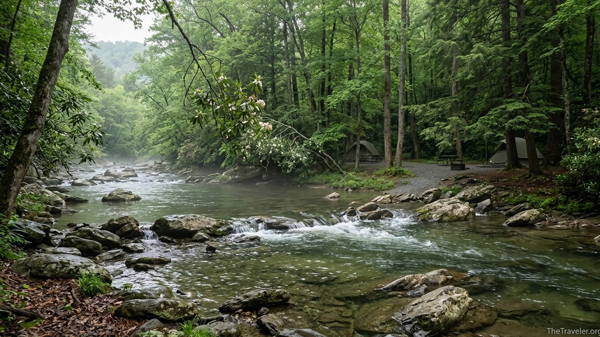
A Quiet Pocket at the Edge of the Smokies
Abrams Creek lies in the westernmost reach of Great Smoky Mountains National Park, where the park boundary brushes up against rural Blount County, Tennessee. Here, instead of neon arcades and pancake houses, the approach is via the Foothills Parkway and narrow country lanes that dead-end beside a clear, fast-moving stream. It is a part of the Smokies that many visitors never see, largely because it sits well away from Gatlinburg and the main park roads.
The National Park Service highlights the Abrams Creek and nearby Look Rock area as a quieter alternative to the park’s busiest corridors, with a small campground, creekside access, and a cluster of less-traveled trails that fan out into the backcountry. The stream itself is underlain by limestone, an uncommon geology in the Smokies, which creates an unusually rich aquatic ecosystem and supports several rare fish species. You notice it instantly in the clarity and color of the water: a cool, green-blue ribbon that looks almost spring-fed as it winds past rounded boulders and gravel bars.
Because this corner sits at just over 1,000 feet above sea level, it tends to be warmer than the high ridges. In spring, wildflowers appear here early; by early April, dogwoods can be blooming along the creek bank while the crest of Clingmans Dome is still holding patches of snow. In autumn, that lower elevation means mid to late October often brings a last, glowing wave of color to the cove hardwoods long after the leaves have dropped higher up.
What you rarely find at Abrams Creek are crowds. Visitors accustomed to bumper-to-bumper traffic on the Cades Cove Loop Road are often surprised to drive the final half mile to the ranger station and discover only a few cars parked along the creek, even on peak-season weekdays.
The Campground Where the Creek Sets the Pace
Abrams Creek Campground is one of the smallest frontcountry campgrounds in Great Smoky Mountains National Park, with just 16 sites tucked into a shaded riverside loop. According to park and regional camping guides, all sites are reservable and the nightly fee is in line with other Smokies campgrounds, around the thirty-dollar range per night for a standard tent site as of the 2025 season. Reservations are handled through the same federal system used for other park campgrounds, and the season typically runs from late April until the end of October.
The facilities are intentionally minimal. There are no showers, no camp store, and no hookups. The sites have the basics: a picnic table, fire ring with a grate, and access to restrooms with cold water. The National Park Service allows small trailers and RVs up to about 12 feet, but tent campers make up most of the crowd, in part because the narrow, winding access road discourages large rigs. Campground regulars often describe it as a place where the dominant sound is the creek, not generator hum.
That stripped-back infrastructure is precisely what appeals to travelers seeking a quieter Smokies base. With only 16 campsites, even a full campground feels intimate compared with larger complexes such as Elkmont or Cades Cove, which can host hundreds of campers on a busy summer night. If you choose a creekside site, you can step out of your tent at dawn, walk ten paces, and be standing in the mist off the water, watching small eddies form behind rocks where trout lie in wait.
Practically speaking, this is a place where preparation pays off. The nearest full grocery stores and outdoor outfitters are in towns like Maryville and Townsend, between 30 and 45 minutes away by car. Most campers arrive with food for several days, extra layers for chilly nights, and a few comforts such as camp chairs and lanterns. Firewood can sometimes be purchased outside the park on the way in, but travelers should look for locally sourced, heat-treated bundles approved for use within the Smokies to avoid transporting invasive pests.
Hiking Trails That Trade Crowds for Quiet
From the edge of the campground, a network of trails fans out into the western backcountry. Cooper Road, Rabbit Creek, and the Little Bottoms Trail all begin near Abrams Creek, linking into longer loops that can carry you deep into the park’s interior. These routes typically see far fewer day hikers than better-known names like Alum Cave or Chimney Tops, so hikers often report long stretches of walking without seeing another group.
Cooper Road Trail follows an old wagon road that once connected Cades Cove to communities to the west. Today it is a broad, gently rolling footpath that makes an excellent long day hike for visitors who prefer distance over steep grades. Rabbit Creek Trail drops closer to the water and winds through open hardwood forest, with occasional narrow, rooty sections that remind you these are true mountain paths, not manicured parkways.
For those willing to commit to a bigger day, the Abrams Falls Trail can also be reached via connecting routes from the Abrams Creek side of the park, creating a roughly 10-mile round-trip adventure to one of the Smokies’ most popular waterfalls. While the standard approach from Cades Cove can feel like a procession on busy weekends, linking into the falls from Abrams Creek gives you a sense of pilgrimage: quiet woods, creek crossings, and a final approach to the thunder of water pouring over a wide rock ledge into a deep pool.
Even the short, informal walks around the campground have their charm. A casual evening stroll along the gravel road out toward the ranger station might reveal deer browsing in the meadows, or the flash of a kingfisher working the bends in the creek. Because this area sits away from major highways, sound carries differently; on a still night, you might hear nothing but the water and a faint chorus of tree frogs.
Trout, Swimming Holes, and Life Along the Water
Abrams Creek is famous among regional anglers for its trout. Fed by limestone springs, the water here tends to be less acidic than in many Smokies streams, which means more aquatic insects and, in turn, faster-growing fish. Fly fishing guides regularly single out the Abrams watershed as one of the park’s premier rainbow trout fisheries, with fish that average noticeably larger than those in neighboring creeks.
Fishing within Great Smoky Mountains National Park requires a valid Tennessee or North Carolina fishing license, which visitors can purchase in nearby towns or online before they arrive. The park’s regulations typically require single-hook, artificial lures or flies, with daily creel and size limits designed to protect the resource. In practice, many anglers who frequent Abrams Creek fish it as a largely catch-and-release stream, using barbless hooks and carefully releasing rainbows back into the current.
Beyond fishing, the creek is dotted with small cascades and pockets where the water slows into deeper pools. On hot summer days, campers often walk up or downstream from the campground to find their own private swimming hole, a place where they can wade out to knee or thigh depth and sit against a sun-warmed rock. Because flows can fluctuate after heavy rain, most locals advise scouting any pool carefully before plunging in, avoiding high water or strong currents, and keeping a close eye on children along the banks.
Wildlife tends to concentrate near the water as well. Great blue herons hunt the shallows, river otters sometimes work the bends at dawn or dusk, and in late spring the creekside rhododendron bloom with pink and white clusters that overhang the riffles. This is archetypal Smokies scenery, but experienced alone or with a few other early risers instead of a tour bus crowd.
Getting There: The Long, Quiet Road In
Part of what keeps Abrams Creek tranquil is the road that delivers you there. The standard approach for most visitors coming from Knoxville or Maryville is to take the Foothills Parkway to Happy Valley Road, then follow Abrams Creek Road to the campground and ranger station. The final stretch is narrow and winding, with several tight curves and few pullouts, which naturally keeps large RVs and commercial traffic to a minimum.
Travel times vary with season and traffic, but as a general guide, Abrams Creek sits roughly an hour’s drive from downtown Maryville and a bit over ninety minutes from Gatlinburg, assuming clear roads. That makes it less convenient for travelers who want to spend each day in the Gatlinburg corridor or on Newfound Gap Road, but ideal for those who plan to focus on the western side of the park, the Foothills Parkway overlooks, or nearby Chilhowee Lake on the Little Tennessee River.
Cell service in and around Abrams Creek is sparse to nonexistent for most major carriers. Visitors relying on smartphone navigation often download offline maps in advance or carry printed directions. Once in camp, many travelers view that lack of connectivity as a feature rather than a bug: an enforced digital detox that encourages lingering by the fire ring, long conversations, and early nights.
Because there are no fuel stations inside this corner of the park, drivers typically top off in towns like Townsend, Walland, or Maryville before heading in. On busy holiday weekends, it is wise to arrive earlier in the afternoon, both to secure a relaxed check-in window and to navigate the access road before dusk, when wildlife crossings become more common.
When to Visit and What to Expect in Each Season
Like the rest of Great Smoky Mountains National Park, Abrams Creek changes character with the seasons. In spring, usually from late March through May, the creek corridor bursts into bloom with trillium, violets, and foamflower along the moist banks, while migrating warblers move through the tree canopy. Daytime highs in April often sit in the comfortable 60s and 70s Fahrenheit, with cool nights that still call for a warm sleeping bag.
Summer brings lush greenery and higher humidity, but also the reward of long, light-filled evenings. In June and July, daytime highs in this low-elevation pocket can climb into the 80s, making shady creek walks and swimming holes especially appealing. Many families time their stay so that kids can splash in the water after breakfast, take a midday rest in camp, and then head out for an easy evening hike when the air cools.
Autumn is perhaps the most coveted window. From late September into October, the cove hardwoods shift through a palette of gold, amber, and scarlet, often peaking a bit later here than on the higher ridges. Crisp mornings, clear air, and thinned foliage also make this one of the best times for wildlife watching along the creek and on the approach roads. By early November, many leaves have fallen, revealing broader views up to the surrounding ridgelines.
Winter feels especially remote at Abrams Creek, even outside the campground’s main operating season. While the developed sites typically close in late fall, day visitors can still drive in when roads are open, hiking the surrounding trails under bare branches and low, slanting light. Frost-fringed rocks along the creek and the low sun on the ridges lend the landscape a quieter, starker beauty that contrasts sharply with the park’s busy summer tableau.
Planning a Stay: Practical Tips for a Peaceful Visit
Securing a campsite at Abrams Creek requires a bit of forethought, especially for peak-season weekends. Because there are only 16 sites, summer Saturdays and fall foliage weekends often book out in advance. Travelers with fixed dates commonly reserve several weeks or more ahead, while those with flexible schedules sometimes target Sunday through Thursday nights, when availability is typically better and the campground feels even more hushed.
Once you have a reservation, think of Abrams Creek as a low-service, high-reward base camp. Arrive with a well-stocked cooler, a simple camp kitchen setup, and any comfort items you care about, from a reliable camp stove and fuel to extra layers and a tarp in case of rain. A compact water filter or purifier can be useful for hikers who plan to spend full days on the trail, refilling from backcountry streams where permitted.
Good trail footwear is important, as many routes near Abrams Creek involve occasional mud, roots, or creekside rock hopping. Lightweight hiking shoes or boots with grippy soles work well for most visitors. Trekking poles can make uneven terrain and creek fords more stable, especially after rain when banks can be slick. In warmer months, hikers often pack a lightweight sun shirt and a brimmed hat for long stretches in open woods or along the water.
Finally, even in a quieter corner of the Smokies, standard backcountry etiquette applies. Store all food and scented items securely, follow park rules for campfires, and pack out every scrap of trash. By keeping noise levels modest and lights low at night, visitors help preserve the very attribute that draws people to Abrams Creek in the first place: a sense of unhurried calm.
FAQ
Q1. Where exactly is Abrams Creek in Great Smoky Mountains National Park?
Abrams Creek sits in the far western section of the park in Blount County, Tennessee, reached by driving the Foothills Parkway and then following local roads such as Happy Valley Road and Abrams Creek Road to the campground and ranger station area.
Q2. How many campsites are at Abrams Creek Campground?
The campground is very small by Smokies standards, with just 16 frontcountry campsites arranged along a single loop road beside the creek, which helps keep the overall feel quiet and intimate.
Q3. When is Abrams Creek Campground open for camping?
Seasonal operating dates can vary slightly year to year, but the campground generally opens in late April and closes around the end of October, with reservations required during the open season.
Q4. Can I bring an RV or trailer to Abrams Creek?
Small trailers and compact RVs are technically allowed up to about 12 feet in length, but the narrow, winding access road and basic facilities make this campground best suited to tent camping and small setups.
Q5. Is there cell service or Wi‑Fi at Abrams Creek?
Most visitors report little to no cell signal in and around the campground, and there is no Wi‑Fi, so travelers should plan for limited connectivity and download maps or information in advance.
Q6. What kind of fishing is available on Abrams Creek?
Abrams Creek is known for its trout fishing, particularly rainbow trout, and anglers typically use artificial lures or flies under park regulations while carrying a valid Tennessee or North Carolina fishing license.
Q7. Are there easy hiking options starting from Abrams Creek?
Yes, trails such as Cooper Road and sections of Rabbit Creek offer relatively gentle grades and can be tailored into shorter out-and-back hikes directly from the campground area, ideal for families or casual walkers.
Q8. How far is Abrams Creek from Gatlinburg and other popular park areas?
Driving times depend on traffic, but Abrams Creek is roughly an hour and a half from Gatlinburg by car, making it more convenient for exploring the park’s western side than for daily trips to the main tourist corridors.
Q9. Do I need to worry about bears at Abrams Creek?
Black bears live throughout Great Smoky Mountains National Park, including around Abrams Creek, so visitors should store food properly, keep a clean campsite, and follow all posted park guidelines for wildlife safety.
Q10. Is Abrams Creek a good choice for first-time Smokies visitors?
For travelers who value quiet, simple facilities, and easy access to water and woods over amenities and nightlife, Abrams Creek is an excellent first base, offering a calmer introduction to the Smokies than the busy Gatlinburg corridor.