
Perched high on the state line between Tennessee and North Carolina, Charlies Bunion is one of those Great Smoky Mountains hikes people talk about years later. The rocky outcrop, reached by an 8 mile out and back along the Appalachian Trail from Newfound Gap, serves up layer upon layer of blue ridgelines, sheer drop offs and a true sense of being deep in the high Smokies. It is not the easiest walk in the park, but for many hikers it quickly becomes a must do, bucket list experience.
Get the latest updates straight to your inbox!
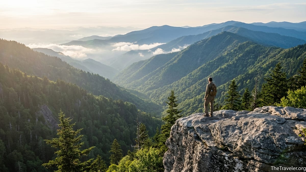
A Classic Smoky Mountains Viewpoint on the Appalachian Trail
Charlies Bunion sits along a high, narrow ridgeline in the heart of Great Smoky Mountains National Park, with the Appalachian Trail cutting right across its northern slopes. From the rock ledge, hikers look out over steep, forested valleys and ridge after ridge of peaks fading into the blue haze that gives the Smokies their name. On a clear afternoon you can pick out giants like Mount Kephart just to the west and Mount Le Conte dominating the skyline beyond, with elevation changes that make the landscape feel genuinely alpine even though you are in the southern Appalachians.
The journey starts at Newfound Gap Overlook, a mountain pass around 5,000 feet that straddles the Tennessee North Carolina border. From the parking lot, the white blazes of the Appalachian Trail lead you straight into high elevation spruce fir forest, a very different world from the leafy hardwoods down in Gatlinburg or Cherokee. The National Park Service describes the route as roughly 8 miles round trip, with a mix of steady climbs and rolling terrain that typically takes day hikers 4 to 6 hours depending on pace and photo stops.
What makes Charlies Bunion feel so special compared with many other overlooks is how close the trail brings you to the cliff edge and how suddenly the view appears. After weaving through mossy forest and glimpses of ridges through the trees, the path swings onto a rocky spur and the terrain drops away on three sides. In good weather you can often see clouds drifting through distant gaps or shadows racing across the valleys, the kind of changing light that keeps photographers, families and thru hikers lingering on the rocks much longer than planned.
Because this section of the Appalachian Trail is relatively accessible yet perched high on the crest of the Smokies, it also carries a sense of connection to the larger trail. You are walking the same ridgeline that long distance hikers follow for more than 2,000 miles between Georgia and Maine. Sharing the outcrop with backpackers cooking simple lunches on tiny stoves or shouldering multi day packs only adds to the feeling that Charlies Bunion is part overlook, part pilgrimage stop on one of America’s most storied footpaths.
Trail Stats: Distance, Difficulty and What the Hike Really Feels Like
On paper, the Charlies Bunion hike is a moderate outing: about 8 miles round trip with around 1,600 to 1,900 feet of total climbing depending on which guide you read. In practice, that means a route that most reasonably fit hikers can tackle in a half day, but that still demands respect. It begins with a firm, well graded path that climbs steadily away from Newfound Gap before settling into rolling ups and downs along the ridge. There are no technical scrambles or exposed knife edges on the trail itself, but the final spur to the rock outcrop has steep drop offs where you must watch your footing.
Many hikers compare the effort level to other popular Great Smoky Mountains routes such as Alum Cave to the bluffs below Mount Le Conte or Rainbow Falls to the large waterfall near Gatlinburg. Unlike short family strolls like Laurel Falls, Charlies Bunion requires sustained walking at higher altitude. Visitors who are used to flat city sidewalks often underestimate how different 4 miles of constant elevation change can feel. Locals frequently suggest training walks on neighborhood hills or stair climbs before vacation if you are not already walking several miles a week at home.
Real world hiking times tell the story more clearly than statistics. A fit day hiker carrying a light daypack may cover the round trip in about 4 hours, moving steadily with only brief photo stops. Families with children, groups stopping for long breaks at Icewater Spring Shelter or hikers adjusting to altitude often spend 5 to 6 hours on the trail. In peak summer, afternoon thunderstorms are common, so park rangers regularly recommend starting by 8 or 9 in the morning to be back at Newfound Gap before lightning builds along the ridge.
Underfoot, the route is a mix of packed dirt, roots, rock steps and occasional muddy patches after rain. In late fall, fallen leaves can hide slick rocks. In winter and early spring, snow and ice are common near the gap and on north facing slopes, and experienced hikers often carry simple traction devices that slip over boots along with trekking poles. The National Park Service notes that in cold seasons you should be prepared for much colder, windier conditions at Newfound Gap than in nearby towns, so a sunny, 55 degree afternoon in Gatlinburg might feel more like the low 40s with wind on the ridge.
Scenery Along the Way: Forests, Shelters and Story Filled Rock
Charlies Bunion is rightly famous for its end view, but much of the hike’s bucket list appeal comes from the scenery along the way. Immediately after leaving Newfound Gap you pass from mixed hardwoods into a high elevation forest of red spruce and Fraser fir, a habitat more commonly associated with New England than Tennessee. On misty mornings, the branches bead with water and the trail feels like a tunnel through clouds, with thick moss and ferns lining the path and the smell of resin and wet earth in the air.
About 3 miles in, a short side path leads to Icewater Spring Shelter, one of the Appalachian Trail’s backcountry shelters. Day hikers often stop here for a snack on the log benches while watching backpackers adjust their gear, filter water or hang bear bags. The shelter is a tangible reminder that while Charlies Bunion is a day hike for many, it is just one rest stop on a far longer journey for others. There is usually a reliable water source nearby, but day hikers are still better off carrying what they need rather than relying on the spring, especially in late summer when flows can be lower.
The rock itself has a story that adds character to the destination. Local lore credits writer and conservationist Horace Kephart with naming the formation in the early 1900s after hiking with his friend Charlie Conner, who reportedly removed his boot to reveal a badly swollen bunion. Kephart is said to have joked that the knobby peak reminded him of his friend’s foot, and the name stuck. Standing on the narrow outcrop today, with the wind tearing at your jacket and the void dropping away below, it is easy to imagine those early hikers seeing the same dramatic folds of land and trading the same gallows humor about rough feet and rough country.
On clear days, you can trace the Appalachian crest east and west from the bunion, spotting landmarks that appear again and again in Smokies guidebooks. To the immediate west rises Mount Kephart, while further off Mount Le Conte forms a distinctive mass above the northern skyline. Looking down, you may pick out the deep valley of Porters Creek and imagine the old logging routes that once climbed these slopes before the establishment of the national park. The interplay of wild scenery and human stories gives Charlies Bunion a sense of place that goes beyond a pretty viewpoint.
Why It Belongs on Your Bucket List: Comparisons and Crowd Patterns
In a park with more than 800 miles of trails, it is fair to ask why Charlies Bunion should make the short list. Visitors often compare it to other headliners like Clingmans Dome, Alum Cave Bluffs or Andrews Bald. The answer usually lies in the combination of accessibility, challenge and drama. Clingmans Dome offers magnificent views from a paved path to an observation tower, but the experience can feel crowded and somewhat detached from the backcountry. Alum Cave provides interesting geology and cliffs, but the trail below Le Conte can be extremely busy in peak season. Charlies Bunion, by contrast, demands a solid hike yet is still reachable from a paved parking area on the main park road, giving you the feeling of earning a genuinely wild panorama.
Crowd patterns reinforce that sense of discovery. Newfound Gap’s large lot can be busy with bus tours and motorists stepping out for a quick look at the state line monument, especially on fall weekends. Yet many of these visitors stroll only a few minutes down the Appalachian Trail before turning back. Hikers who commit to the full 4 miles to Charlies Bunion often find that numbers thin considerably after the first mile or two, especially if they start early in the morning or later in the afternoon outside of summer holidays. Compared with Laurel Falls or the first mile of Alum Cave, you are far more likely to find stretches of quiet trail where you hear nothing but the wind and the occasional call of a raven.
Travel planners also appreciate that Charlies Bunion can be realistically slotted into a wider Smokies itinerary. For example, a couple staying in Gatlinburg for a long weekend might drive the 30 to 40 minutes up Newfound Gap Road, complete the hike in half a day, and still have time to stop at scenic pullouts on the way back or visit Sugarlands Visitor Center. Visitors based in Cherokee on the North Carolina side can make a similar day trip combining the hike with viewpoints like Oconaluftee Overlook. This flexibility makes it easier to add Charlies Bunion to a bucket list trip that might also include auto touring, wildlife watching in Cades Cove or an evening stroll along Parkway attractions in town.
From a photo standpoint, Charlies Bunion consistently shows up in social media and guidebook covers because the rock outcrop naturally frames people against vast empty space. Families pose cautiously near the edge, couples sit with legs dangling over the drop, and solo hikers capture classic backpack over the shoulder silhouettes at sunset. For photographers, the combination of foreground rock texture, middle distance ridges and distant haze is a reliable recipe for memorable images, and that visual payoff is a major reason so many experienced Smokies hikers rank this trail among their top three in the park.
Planning Your Trip: Seasons, Weather and Practical Logistics
Charlies Bunion is hikeable year round in some conditions, but most visitors tackle it between April and November when Newfound Gap Road is less likely to close for snow or ice. In winter, the high pass can be temporarily shut during storms, and the trail itself often holds packed snow and black ice for days afterward. Spring brings changing weather and lingering snow patches, but also clear views before the trees fully leaf out. Late April through May is a favorite period among many hikers who enjoy cool temperatures and emerging wildflowers, while October offers brilliant foliage along Newfound Gap Road and on lower slopes.
Summer is prime time for family vacations in the Smokies, and that shows on the trail. Expect warmer temperatures, more people and a higher chance of afternoon thunderstorms. Rangers frequently advise hikers to carry rain jackets even on blue sky mornings and to keep an eye on the sky as they approach the more exposed sections near the bunion. Lightning is a real risk on the high ridge, so experienced hikers will turn around if thunder starts to rumble nearby, even if they are close to their destination. In muggy weather, many visitors aim for early starts, leaving Newfound Gap between 7 and 8 a.m. to enjoy cooler air and quieter conditions.
Parking logistics are relatively straightforward but still worth planning. Newfound Gap has one of the larger parking areas in Great Smoky Mountains National Park, and turnover is constant because many visitors stop only briefly at the overlook. That said, holiday weekends and peak leaf season can still see the lot temporarily full. Travelers coming from Gatlinburg typically reach the trailhead in about 30 minutes via the scenic drive up Newfound Gap Road, while those starting in Cherokee may take a similar amount of time from the Oconaluftee entrance. Because the park now uses a daily parking tag system, visitors should budget for that small fee along with fuel costs when planning a hiking day.
Typical day hiking gear for Charlies Bunion includes sturdy, broken in shoes or boots, 1.5 to 3 liters of water per person depending on heat, snacks or a simple lunch, a light insulating layer, rain shell, small first aid kit and sun protection. Many hikers bring trekking poles to ease pressure on knees during the descent back to Newfound Gap, especially on the rocky, stepped sections. In shoulder seasons, locals often add a knit hat and gloves to their daypack even if the forecast for nearby towns looks mild, because wind chill on the ridge can be surprisingly sharp. Cell service comes and goes; some carriers may show intermittent coverage near the gap and along parts of the ridge, but hikers should not rely on phones for navigation or emergency contact.
Safety, Sustainability and Respecting a Fragile High Country
Like many bucket list destinations, Charlies Bunion is beautiful partly because it remains relatively wild. Keeping it that way requires a bit of extra care from visitors. The most obvious safety concern is the cliff edge at the outcrop itself. Photos from the very tip of the rock are popular, but footing can be uneven and small bits of gravel or moss can make ledges slick. Rangers and experienced hikers encourage people to stay back from vertical drop offs, supervise children closely and avoid risky poses just for the sake of a dramatic image. The view remains spectacular even several steps from the edge.
Weather is another serious safety factor at this elevation. Conditions can change rapidly, with fog rolling in from one valley and reducing visibility to a few dozen yards within minutes. Hikers occasionally report starting under bright skies at Newfound Gap only to find the bunion completely socked in by clouds, with no views at all. Checking a detailed mountain forecast before leaving town, monitoring radar on a phone if service allows and staying flexible with timing can make the difference between a memorable panorama and a whiteout. In colder months, hidden ice on shaded sections of trail is a common culprit in slips and twisted ankles, which is why traction devices and walking poles are so strongly recommended by many regular Smokies visitors.
From a stewardship perspective, staying on the official trail and rock outcrop is crucial. The high elevation spruce fir ecosystem is slow growing and easily damaged by trampling, so hikers should resist the temptation to cut switchbacks, create social paths to alternate viewpoints or wander out onto fragile vegetated slopes. All trash, including food scraps, tissues and small wrappers, should be packed out. Because this is active black bear country, day hikers also need to manage food carefully, keeping snacks sealed when not in use and never feeding wildlife even if animals appear used to humans. The park has invested in education and, in some areas, bear resistant infrastructure to reduce human wildlife conflicts; responsible behavior at popular spots like Charlies Bunion is part of that effort.
Finally, hikers should be aware of their own limits and those of their companions. It is not uncommon for people to underestimate how long it will take them to return from the bunion to Newfound Gap, particularly if they have spent extra time taking photos or picnicking at the viewpoint. Turning around earlier than planned because of incoming weather, fatigue or slower than expected progress is not a failure but good mountain sense. Carrying a basic headlamp or small flashlight, even for a hike that you fully intend to finish in daylight, is a simple step that has helped many hikers avoid stumbling out in the dark when unforeseen delays arise.
Making It Part of a Bigger Smokies Adventure
For many travelers, Charlies Bunion is just one highlight in a broader Great Smoky Mountains vacation, and planning it that way can make the experience more rewarding. Because the trailhead sits on Newfound Gap Road, the only road that crosses the park fully between Gatlinburg and Cherokee, you can easily combine your hike with scenic overlooks along the drive. Some visitors like to stop at pullouts on the way up in the morning to gauge visibility and cloud levels, then save longer photo sessions at Newfound Gap or Morton Overlook for the drive back after their legs are tired from hiking.
Lodging options near the hike range from rustic to resort style. On the Tennessee side, many people base themselves in Gatlinburg or Pigeon Forge, where rental cabins and budget friendly hotels allow you to be within an hour’s drive of the trailhead. On the North Carolina side, Cherokee offers motels, small inns and access to the quieter Oconaluftee area of the park. A typical real world plan might see a family renting a two bedroom cabin outside Gatlinburg for a long weekend, hiking Charlies Bunion one day, driving Cades Cove another and spending an evening exploring aquarium exhibits or casual restaurants on Gatlinburg’s main strip.
More hiking focused visitors sometimes build a multi day itinerary along the crest. A common approach is to secure a backcountry permit and spend a night at Icewater Spring Shelter or another nearby shelter, combining Charlies Bunion with side trips to places like the Jump Off or Mount Kephart. Others might connect the bunion with a longer Appalachian Trail section hike from Clingmans Dome to Newfound Gap, arranging a shuttle with a local outfitter in Gatlinburg or Cherokee. These kinds of itineraries require more planning, but they allow hikers to experience sunrise and sunset along the ridge, when the Smokies’ famous blue layers are at their most ethereal.
Even if you are not a hardcore backpacker, you can still link Charlies Bunion with other classic day hikes. For instance, one day might feature the bunion from Newfound Gap, while the next could focus on Alum Cave or Andrews Bald from Clingmans Dome Road. This variety gives you a feel for different facets of the park: high ridges, deep coves, waterfalls and historic structures. When travelers later list their favorite moments, the memory of standing on the narrow rock ledge of Charlies Bunion, watching clouds cast shadows across miles of mountains, often stands shoulder to shoulder with wildlife sightings in Cades Cove or evening views from the Clingmans Dome tower.
The Takeaway
Charlies Bunion earns its bucket list reputation by offering a rare combination of qualities: a dramatic, cliff edge viewpoint reached by a classic stretch of the Appalachian Trail, high elevation forests that feel worlds away from nearby towns, a story rich rock formation and a hike that is challenging enough to feel like an accomplishment without being out of reach for reasonably prepared visitors. It is a place where day hikers and thru hikers share the same narrow ledge and the same long views, where the history of early conservationists quietly lingers in the place names, and where the Smokies’ famed blue ridges unfold in every direction.
For travelers planning a Great Smoky Mountains trip, making room in the schedule for Charlies Bunion can mean the difference between simply visiting the park and truly experiencing its backcountry character. With thoughtful preparation for weather, footing, crowds and safety, the hike rewards you with not just photographs but a deeper sense of the landscape that has inspired generations of hikers and writers. Add it to your itinerary alongside more accessible overlooks and scenic drives, and you may find that this rugged spur of rock becomes the moment you remember most vividly when the trip is long over.
FAQ
Q1. How long is the hike to Charlies Bunion and how difficult is it?
It is roughly 8 miles round trip from Newfound Gap on the Appalachian Trail, with around 1,600 to 1,900 feet of total climbing. Most visitors find it moderately strenuous because of the distance, elevation changes and high elevation, but the path is well defined and does not involve technical rock climbing.
Q2. Where does the Charlies Bunion trail start?
The hike begins at the Newfound Gap Overlook parking area on Newfound Gap Road, the main highway crossing Great Smoky Mountains National Park between Gatlinburg, Tennessee and Cherokee, North Carolina. Look for the white blazes marking the Appalachian Trail near the edge of the parking lot.
Q3. Do I need any special permit or reservation to hike Charlies Bunion?
Day hikers do not need a special backcountry permit for Charlies Bunion, but they do need to comply with the park’s parking tag system, which requires a paid tag for vehicles parked more than a short time. Overnight backpackers staying at shelters along the route must secure backcountry permits and, where applicable, shelter reservations through the park system.
Q4. What is the best time of year and day to hike Charlies Bunion?
Late spring through fall is generally the most popular period, with April, May, September and October often offering comfortable temperatures and good visibility. During summer, starting early in the morning helps you avoid heat, crowds and afternoon thunderstorms. In winter, the trail can be icy and Newfound Gap Road sometimes closes for snow, so you should check current conditions before heading out.
Q5. Is Charlies Bunion safe for children and people afraid of heights?
The trail itself is mostly in the forest and feels secure, but the final rock outcrop has steep drop offs and can be intimidating. Many families hike with children and simply keep a safe distance from the cliff edge, staying on flat, stable rock. People with serious fear of heights may prefer to enjoy partial views from just before the outcrop rather than walking onto the narrowest sections.
Q6. Are there restrooms or water sources along the trail?
Restrooms are available at Newfound Gap Overlook but not along the trail itself. There is a spring near Icewater Spring Shelter that backpackers use, but day hikers should not rely on it and are better off carrying all the water they need. If you do use natural water sources, you should treat or filter them before drinking.
Q7. What gear should I bring for a day hike to Charlies Bunion?
Sturdy hiking shoes or boots, 1.5 to 3 liters of water per person, snacks or a light lunch, a rain jacket, an extra warm layer and sun protection are basic essentials. Trekking poles are very helpful for the descent, especially on rocky sections, and in colder months microspike style traction devices and a hat and gloves can make the hike more secure and comfortable.
Q8. How crowded is the trail to Charlies Bunion?
The first mile or two from Newfound Gap can be fairly busy, especially on weekends, holidays and in summer and early fall. However, many people turn around before reaching the bunion, so those who commit to the full hike often find quieter stretches of trail, particularly if they start early in the morning or visit on a weekday outside peak foliage season.
Q9. Can I hike Charlies Bunion in winter?
It is possible to hike Charlies Bunion in winter when Newfound Gap Road is open and conditions are suitable, but snow, ice, high winds and very cold temperatures are common at this elevation. Winter hikers should carry appropriate cold weather clothing, traction devices for icy sections, and be prepared to turn around if weather or trail conditions worsen.
Q10. Is Charlies Bunion suitable as part of a longer backpacking trip?
Yes, Charlies Bunion is a popular highlight on multi day trips along the Appalachian Trail in the Smokies. Many backpackers plan itineraries that include a night at Icewater Spring Shelter or other nearby shelters, combining the bunion with destinations like the Jump Off, Mount Kephart or longer sections between Newfound Gap and Clingmans Dome, all arranged through the park’s backcountry permit system.