
The highest place in Great Smoky Mountains National Park is not the jagged peak many visitors imagine when they picture the Southern Appalachians. Instead, the summit known traditionally as Kuwohi and widely as Clingmans Dome is a broad, forested crest capped by a modern concrete observation tower. At 6,643 feet above sea level, it is the park’s literal high point and one of the most distinctive mountaintops in the eastern United States. Understanding what makes Clingmans Dome the highest point in the Great Smokies reveals a story of geology, ecology, engineering, and the way millions of travelers experience this famous park each year.
Get the latest updates straight to your inbox!
A Summit Above the Smokies
Clingmans Dome, now officially recognized by the National Park Service under its Cherokee name Kuwohi, reaches an elevation of about 6,643 feet. That number matters in a landscape where most familiar ridges above Gatlinburg or Cherokee top out thousands of feet lower. For context, downtown Gatlinburg sits around 1,300 feet. On a clear day, standing on the observation tower feels like being in a small, open-air airplane cabin looking down at layered ridges that fade to blue on the horizon. The towers of Pigeon Forge and Sevierville, major tourist hubs that many visitors drove through earlier that morning, lie far below and out of sight.
Clingmans Dome is not just the highest point in Great Smoky Mountains National Park. It is also the highest peak in the entire Great Smoky Mountains range, the highest point in Tennessee, and the loftiest spot along the roughly 2,200-mile Appalachian Trail. Hikers who have been working north from Springer Mountain in Georgia for weeks often describe the brief stroll up to the concrete tower as both a physical shock and a psychological milestone. However you arrive, every step at this elevation is a reminder that you are walking on the very top of one of America’s most visited national parks.
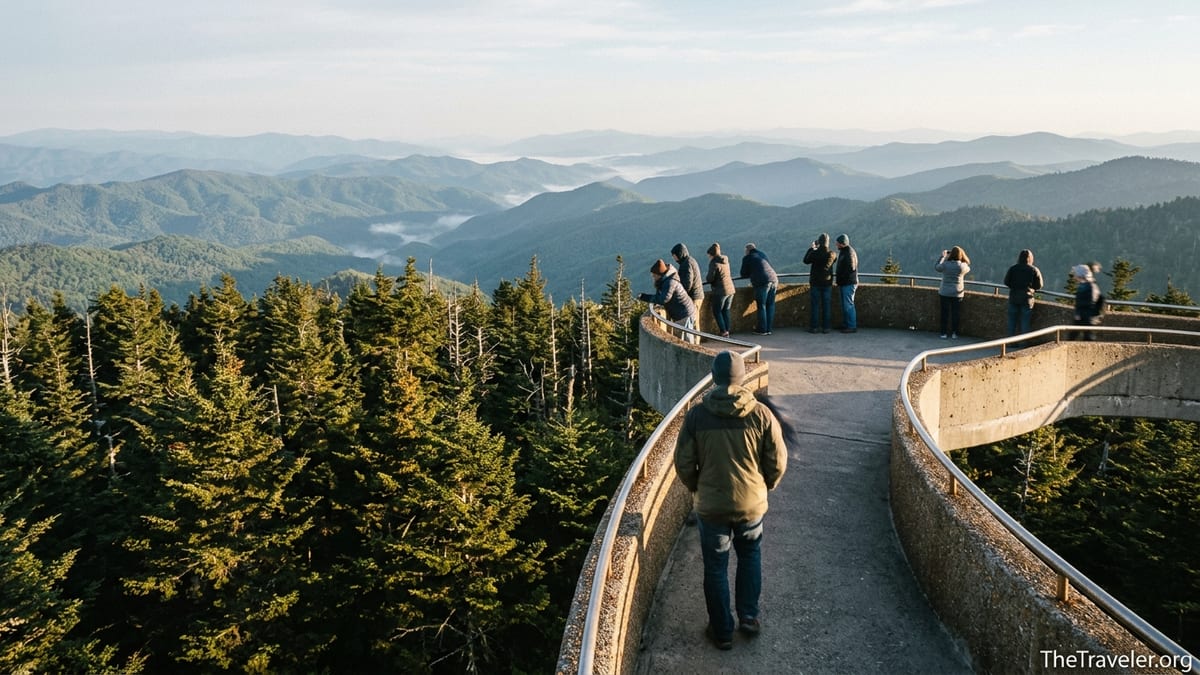
From the parking area, visitors climb a steep but short paved path of about half a mile one way, with roughly 330 feet of elevation gain. That climb feels entirely different from a stroll along the Little River or a walk around Cades Cove. The thinner air, brisk wind and often swirling clouds emphasize how much higher this point is than the valleys only an hour’s drive away. Parents coaxing children up the hill, hikers leaning on the low stone wall for a breather and cyclists locking bikes at the lot all share the same realization: there is simply nowhere higher to go in the Smokies.
How the Mountains Made a High Point
Clingmans Dome’s dominance in the Smokies is a story written in ancient rock. The mountain crowns the main crest of the Great Smoky Mountains, a long, curving spine that straddles the Tennessee–North Carolina border. This crest is built mostly of resilient Precambrian sandstone and other hard metamorphosed rocks that have resisted erosion for hundreds of millions of years. While softer layers around it wore down, Kuwohi’s tougher rock remained as a slightly higher dome, just enough to nudge it above other close rivals like Mount Guyot and Mount Le Conte.
On a modern topographic map, the difference between these summits looks small. Mount Guyot, for example, rises only about 20 feet lower than Clingmans Dome. Yet such fine distinctions are exactly what define a “highest point.” Surveyors working in the 19th and 20th centuries used painstaking measurements to confirm Kuwohi’s 6,643-foot elevation. More recent GPS-based surveys have refined those figures, but all confirm that Clingmans Dome edges out every other summit in the national park. For visitors, the difference is not obvious to the eye, but you can feel it in the longer lingering snowfields and colder wind at the crest.
Another key reason Clingmans Dome holds the title is its position along a long, continuous ridge where many peaks rise above 5,000 feet for more than 30 miles. That unbroken skyline gives the Great Smokies their name and creates the visual impression of wave after wave of mountains. But even in this high company, Kuwohi stands on a slightly taller swell of rock. Hikers approaching along the Appalachian Trail from Newfound Gap notice how the path steadily climbs to a broad, rolling summit. They may not see a sharp peak, but the GPS screens clipped to many backpack straps confirm what the contour lines already show: the numbers climb just a little higher here than anywhere else in the park.
A Different World at 6,643 Feet
Being the highest point in the Great Smokies is not only about numbers. Clingmans Dome also feels different because its climate more closely resembles Canada than the Carolina and Tennessee valleys that surround it. As a rule of thumb, temperatures drop about 3 to 4 degrees Fahrenheit for every 1,000 feet of elevation gain in these mountains. That means that when Gatlinburg bakes at 85 degrees on a July afternoon, the summit of Kuwohi can be sitting in the low 60s with a steady, chilly wind. Many summer visitors who arrive in T-shirts and sandals dash into the small information center to buy a hoodie when they step out of the car and feel the shock of the air.
The cooler, wetter environment at this altitude supports a high-elevation spruce-fir forest more typical of Quebec or Nova Scotia than the Deep South. Red spruce and Fraser fir crowd together along the upper slopes, their needles whispering in constant wind. Travelers who have just driven up from the lush, broad-leaf forests around Elkmont or Deep Creek often remark that it feels like they have crossed several state lines on the way up. In autumn, when maples flame red in the valleys, the summit forest transitions to a darker, evergreen mood punctuated by rime ice and early dustings of snow.
This harsh climate also explains the frequent fog and cloud that blanket the observation tower. Locals often joke that visitors either see seven states or can hardly see their own hands. On an October afternoon, it is common for a family to arrive in bright sunshine, hike ten minutes up the path, and find themselves in swirling mist that feels like another season entirely. That same cloud-prone environment has made Kuwohi valuable to scientists; the Environmental Protection Agency and other researchers have used the summit area for long-term monitoring of air quality and cloud-borne pollution drifting across the Appalachians.
The Observation Tower That Lets You Stand Above the Trees
Another feature that makes Clingmans Dome stand apart is something humans built rather than nature: the round, concrete observation tower that rises 45 feet above the summit. Completed in 1959 as part of the National Park Service’s Mission 66 modernization program, the tower looks a bit like a flying saucer hovering above the trees. Its long, sweeping ramp arcs gently upward, allowing visitors to gain extra elevation without climbing stairs. The design was controversial when it was built but has since become an icon of the park’s mid-century architecture and is listed on the National Register of Historic Places.
The tower is what allows Clingmans Dome to deliver the full promise of being the park’s highest point. Because the summit itself is broad and forested, without the tower you would mostly see the spruce-fir canopy around you. By lifting visitors just high enough to clear the tallest trees, the platform provides an unobstructed 360-degree panorama that reveals ridgelines all the way to distant ranges in North Carolina, Tennessee, and beyond. On a clear, less hazy day, rangers say visibility can reach close to 100 miles. Travelers recognize familiar names like Thunderhead Mountain, Gregory Bald, and Mount Le Conte on orientation panels bolted to the railings.
In practice, the human-made and natural highpoints blend into a single experience. On a typical summer morning, the parking lot begins to fill shortly after the Clingmans Dome Road opens. Families push strollers as far up the steep pavement as they can, grandparents pause at benches to catch their breath, and trail runners use the grade for quick alpine training before work. At the top, the circular platform crowds with visitors holding out phones and cameras in every direction. Tour guides point out specific ridge systems, and Appalachian Trail thru-hikers lean against the concrete rail, momentarily ignoring their pack weight as they savor the knowledge that they are standing at the literal and symbolic roof of the Smokies.
Reaching the Highest Point: Roads, Trails, and Seasons
Accessibility is a major reason Clingmans Dome is the most widely experienced true high point in the park. A side road, Clingmans Dome Road, branches off Newfound Gap Road near the state line and climbs seven miles to a large parking area just below the summit. While the observation tower and paved walkway are technically open year-round, this access road usually closes to vehicles from early December through the end of March due to snow and ice at high elevation. In early spring and after heavy snowfalls, travelers can sometimes walk or bike the quiet, closed road to enjoy a rare sense of solitude at the Smokies’ highest overlook.
When the road is open, the experience feels different. On a sunny Saturday in June or October, motorists may find a queue of cars waiting for one of the limited parking spaces to open up. It is common for the lot to be full by mid-morning, and many drivers arrive to find rangers directing them to circle or look for space along the shoulder where allowed. Visitors who plan ahead often arrive at sunrise or near sunset, not only to avoid the thickest crowds but also to catch the most dramatic light. A family staying in Gatlinburg, for example, might leave town around 5:30 a.m., drive up as the sky brightens, and arrive to watch the sun break through a blanket of fog below the tower.
For hikers, the highest point is also a major junction. The Appalachian Trail crosses the parking area and skirts just below the summit, making Kuwohi one of the most celebrated milestones on any northbound thru-hike. Other routes like the Forney Ridge Trail descend from the lot toward Andrews Bald, giving day hikers a chance to combine the summit viewpoint with a quieter, grassy bald ramble. Strong hikers sometimes plan one-way point-to-point days that use the Clingmans Dome parking area as a shuttle drop, descending long ridges such as Forney Creek or Noland Divide to trailheads far below. In every case, the fact that you are starting or finishing at the park’s highest point adds psychological weight to the trip.
Clingmans Dome in the Context of the Great Smokies
To appreciate why Clingmans Dome is such a meaningful high point, it helps to see it in context of the wider Great Smoky Mountains National Park. This is the most visited national park in the United States, with annual visitation in recent years reaching well over 12 million recreational visits. Many of those visitors never step onto a trail, but a significant share make the drive to one or two famous destinations. Park studies routinely list Cades Cove, Sugarlands Visitor Center, and Clingmans Dome among the most frequently visited locations, meaning that millions of people experience Kuwohi not as an obscure geologic fact but as a concrete, personal memory of the park.
Other summits in the Smokies have strong claims to fame. Mount Le Conte, for instance, is revered by hikers for its dramatic cliffs and overnight lodge, and it offers some of the greatest vertical relief in the eastern United States between its base near Gatlinburg and its lofty crest. Mount Guyot, slightly lower than Clingmans Dome, is wilder and more remote, requiring a lengthy backcountry approach. Yet neither of these peaks combines elevation, easy road access, and a purpose-built observation tower in the way Kuwohi does. That combination is what transforms a statistic about maximum elevation into a shared cultural touchstone for travelers.
Clingmans Dome is also a symbolic summit for the Appalachian region. The restoration of the Cherokee name Kuwohi reflects a broader recognition of Indigenous connections to these mountains that long predate the creation of the national park in 1934. For Cherokee communities, this high peak figures in traditional stories and geographic knowledge, not just in visitor center brochures. As more interpretive signs and ranger programs begin to use both names, travelers are reminded that “highest point” can mean more than a reading on a survey marker. It can also signify a place where multiple layers of human history, from Cherokee homelands to Civilian Conservation Corps projects to 1950s park modernization, converge on a single mountaintop.
Planning Your Own Visit to the Roof of the Smokies
Understanding why Clingmans Dome is the highest point in Great Smoky Mountains National Park is one thing; experiencing it is another. Travelers planning a visit should think practically about what those 6,643 feet mean. For starters, pack warmer layers than you think you will need. In mid-summer, a thin fleece or light puffer jacket can make the difference between cutting your visit short and lingering to watch clouds roll over the ridges. In spring and fall, gloves and a beanie are surprisingly useful, especially at dawn and dusk. Even in late May, you may find patches of snow or ice hanging on in shaded corners of the path when the lower valleys are blooming with wildflowers.
Weather at the highest point is notoriously fickle, so flexible expectations help. Travelers who book a cabin in Gatlinburg or Bryson City for a long weekend often plan two potential days for a Clingmans Dome visit. If one afternoon turns out foggy with zero visibility, the other might bring clearer skies. Smartphone weather apps give a general idea but cannot always predict cloud layers forming at this specific altitude. Many visitors simply decide that the atmosphere of walking through the clouds is worthwhile even without expansive views, turning what might seem like a disappointment into a memory of swirling mist and wind-whipped trees.
Finally, remember that the short, paved walk is steep. It is technically accessible in terms of surface, but the grade is challenging for some visitors using wheelchairs, walkers, or strollers. Families often take a slow, social approach, pausing at stone benches or low walls, sharing snacks, and encouraging younger hikers with promises of the view from “the very top of Tennessee.” Arriving outside the busiest midday hours can make the ascent more pleasant and give you more space on the tower platform to turn slowly and take in what, by any definition, is the highest perspective available in the Great Smoky Mountains.
The Takeaway
Clingmans Dome, or Kuwohi, is the highest point in Great Smoky Mountains National Park because of a fortunate alignment of geology, climate, engineering, and access. Ancient, erosion-resistant rock lifted the summit just enough above its neighbors to earn the official high-point title. A harsh, high-elevation climate created a spruce-fir world that feels more northern than southern. A mid-century concrete observation tower transformed a forested crest into a 360-degree balcony in the sky. And a winding access road made it possible for families in minivans, long-distance hikers, and casual sightseers alike to share the same rare vantage.
In a park defined by misty ridges and deep hollows, Kuwohi stands not as a jagged spike but as a broad, accessible rooftop. Travelers who make the effort to drive, hike, or even cycle up to this summit do more than check off a superlative on a map. They feel the sudden drop in temperature, see the forest change around them, and watch ridgelines roll away in every direction. That full-sensory experience is what truly makes Clingmans Dome the high point of the Great Smokies, in every sense of the term.
FAQ
Q1. How high is Clingmans Dome compared to the rest of the Smokies?
Clingmans Dome rises to about 6,643 feet, making it the highest point in Great Smoky Mountains National Park, the highest peak in Tennessee, and slightly higher than nearby Mount Guyot and Mount Le Conte.
Q2. Why is it called both Clingmans Dome and Kuwohi?
Clingmans Dome is the long-used English name, honoring a 19th-century surveyor, while Kuwohi is the traditional Cherokee name that the National Park Service has begun using officially to recognize Indigenous connections to the mountain.
Q3. How hard is the walk to the observation tower?
The paved path from the parking lot to the tower is only about half a mile one way, but it is quite steep, gaining roughly 300 feet in elevation. Most visitors can complete it with rest stops, though it can be challenging for those with limited mobility.
Q4. When is Clingmans Dome Road open to vehicles?
In most years, Clingmans Dome Road is open roughly from early April through late November, then closed to vehicles in winter due to snow and ice. Exact dates vary with conditions, so visitors should check current park information before driving up.
Q5. What is the weather like at the summit?
The summit is much cooler and windier than the valleys. Temperatures are often 15 to 20 degrees Fahrenheit lower than in nearby towns like Gatlinburg, and clouds frequently envelop the tower, especially in spring and summer.
Q6. Can you see multiple states from the top?
On clear days with low haze, visitors from the observation tower can see ridge systems stretching into several surrounding states, sometimes as far as around 100 miles. On hazy or cloudy days, visibility can be limited to the nearest ridges.
Q7. Is Clingmans Dome accessible in winter?
The observation tower and paved trail remain open year-round, but the access road is usually closed to vehicles in winter. Ambitious visitors sometimes hike or bike the closed road when conditions are safe, though snow, ice, and cold are common.
Q8. Are there hiking trails that connect to Clingmans Dome?
Yes. The Appalachian Trail crosses just below the summit, and other trails such as Forney Ridge Trail begin at the parking area. These routes allow hikers to link the high point with destinations like Andrews Bald and longer backcountry trips.
Q9. Why does the summit forest look different from the valleys?
Because of the cooler, wetter climate at 6,643 feet, Clingmans Dome supports a spruce-fir forest more typical of higher latitudes. This contrasts with the mixed hardwood forests of the lower elevations and contributes to the mountain’s distinct character.
Q10. Do I need any special gear to visit the highest point?
Most visitors only need sturdy shoes, layered clothing, and water. Even on warm days, a light jacket or fleece is recommended, and in shoulder seasons gloves and a hat can make time on the exposed observation tower much more comfortable.