
There are plenty of beautiful roads in the Southern Appalachians, but few are as legendary as Newfound Gap Road, the sinuous 34 mile ribbon of U.S. 441 that climbs from Cherokee, North Carolina to Gatlinburg, Tennessee through the heart of Great Smoky Mountains National Park. Linking two gateway towns while cresting at more than 5,000 feet, it compresses the Smokies experience into a single drive: sweeping overlooks, trailheads to marquee hikes, high elevation spruce fir forest, and a powerful sense of history at the place where a national park was born.
Get the latest updates straight to your inbox!
The Spine of the Smokies
Newfound Gap Road is the primary east west artery of Great Smoky Mountains National Park, officially designated a state scenic byway in both Tennessee and North Carolina. The road runs about 34 miles between downtown Cherokee and the Sugarlands entrance near Gatlinburg, climbing from valley floors near 1,900 feet to its high point at Newfound Gap, roughly 5,046 feet above sea level. Drivers effectively cross the full width of the Smokies, with the crest of the range and the Tennessee North Carolina state line directly under their wheels for several miles.
What makes this route so distinctive is how rapidly the landscape changes over a relatively short distance. Leaving Cherokee, you start in a humid hardwood forest that in summer feels almost subtropical. By the time you pull into the Newfound Gap Overlook parking plaza 30 to 40 minutes later, the forest has shifted to dark spruce fir, the air is often 10 to 15 degrees cooler, and the sweeping views feel more like New England than the Deep South. Park staff often describe the drive as the equivalent of traveling from Georgia to Maine in under an hour, based on the ecological zones you pass through.
Unlike some Western mountain passes that are all about hairpin turns and exposure, Newfound Gap Road was engineered to deliver scenery at a relaxed, family friendly pace. Curves are frequent but generally gentle, speed limits sit mostly at 35 miles per hour, and the National Park Service incorporated formal pullouts, stone walled overlooks, and large parking areas so visitors can stop to enjoy views safely rather than improvising on the shoulder. That combination of accessibility and drama is a big reason the road sees millions of vehicle trips each year in peak seasons.
For many travelers, Newfound Gap Road is their first and only deep foray into the park’s interior. A family staying in a Gatlinburg hotel might drive up in a rental SUV, stop at the Chimney Tops overlook to photograph the twin rock spires, linger at Newfound Gap for 45 minutes, then continue on to Cherokee for lunch and a visit to the Museum of the Cherokee People before looping back. In a single day, they have crossed a major mountain range twice, stood on the Appalachian Trail, and experienced some of the most iconic vistas in the Smokies without ever leaving pavement.
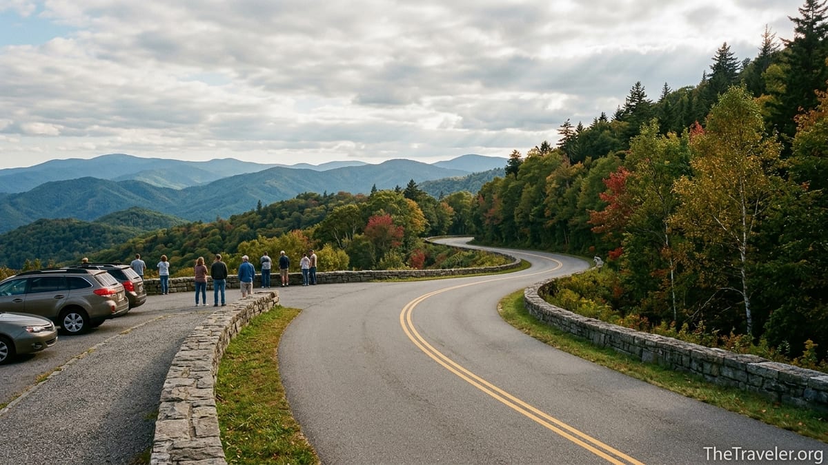
Iconic Views and Classic Overlooks
From a driver’s perspective, Newfound Gap Road is a rolling sequence of viewpoints. Long before you reach the actual gap, you encounter signed overlooks like the Chimneys, Morton Overlook, and Webb Overlook, each with its own character. At Chimneys, the craggy turret of Chimney Tops rises abruptly above the West Prong of the Little Pigeon River, a favorite spot for sunrise photographers who frame the peak against deep blue pre dawn light. Morton Overlook, a small pullout on the Tennessee side, is renowned for sunsets where the sun drops behind wave after wave of ridgeline, each one fading a shade bluer into the distance.
The star attraction, though, is the Newfound Gap Overlook itself. Here, a broad parking plaza, stone walkways, and low guard walls create a kind of outdoor balcony suspended above the undulating sea of mountains. On a clear day, you can see layered ridges marching away toward North Carolina, with the road you just drove snaking below. In October, those ridges blaze with color, from scarlet sourwoods and red maples down low to yellow birches and golden beeches at mid elevations, one of the reasons fall weekends often bring near full parking lots by mid morning.
Practical details matter for visitors planning a stop. The Newfound Gap parking area is large by national park standards and free, but it can still feel tight on popular Saturdays in October or during spring break. Arriving before 9 a.m. often means a choice of spaces, including pull through spots that work better for small RVs. Seasonal restrooms and informational exhibits sit just off the central plaza, and short paved walkways lead to multiple viewing angles, so even travelers with limited mobility can enjoy the panorama without tackling steep grades.
What surprises many first time visitors is how quickly conditions can shift along this high stretch. On a July afternoon, it might be 85 degrees in Gatlinburg but barely in the low 60s with a stiff wind at Newfound Gap, leaving shorts clad vacationers huddled in the lee of the Rockefeller Memorial. In winter, the same plaza may be rimmed with snowbanks while the valleys see only cold rain. Checking the park’s current conditions page before leaving town, and tossing a fleece or light puffer in the back seat even in summer, can make the difference between a quick dash from the car and a leisurely half hour soaking in the view.
Where History Meets the Highway
Newfound Gap Road is far more than a pretty drive. It is also a corridor of American conservation history and Appalachian culture. Before the national park existed, residents and traders used a rough wagon route over nearby Indian Gap to move livestock and goods across the mountains. Survey work in the 1800s eventually revealed that the saddle now called Newfound Gap was slightly lower and more practical as a highway route, giving this “newly found” pass its name. When Great Smoky Mountains National Park was created in the 1930s, engineers seized the opportunity to align the park’s main road with this lower crossing.
The most conspicuous historical landmark sits right at the gap: the Rockefeller Memorial. This stout stone platform and terrace commemorates the $5 million donation from the Rockefeller family that helped purchase the land for the park during the Great Depression, at a time when many local families were selling timber rights and farmland just to get by. On September 2, 1940, President Franklin D. Roosevelt stood at this very spot to dedicate Great Smoky Mountains National Park, addressing a crowd while clouds drifted through the spruce tops behind him. Today, visitors can stand in the same place, read interpretive panels, and imagine that ceremony against the constant backdrop of distant ridges.
There is cultural meaning here as well. The Tennessee North Carolina state line runs right through the overlook, marked by a simple sign that has become a classic vacation photo op. Families line up to pose with one foot in each state, children jumping back and forth while parents snap photos on phones. Behind that playful moment lies the reality that the park protects the headwaters of streams flowing in both directions, safeguarding drinking water and biodiversity for two states in one continuous swath of forest.
For communities on both sides of the mountains, the road has long served as a lifeline and an economic engine. Cherokee outfitters rely on visitors driving up from town to book fly fishing trips, while Gatlinburg restaurants see steady lunch and dinner traffic from day trippers who base in Pigeon Forge but spend their days exploring the park. When winter storms or maintenance projects temporarily close the pass, local news outlets in both states cover it as a regional story, precisely because so many residents, workers, and small businesses feel its impact.
Gateway to Legendary Trails and High Peaks
Another reason Newfound Gap Road is so revered is that it serves as a trailhead highway for some of the Smokies’ most famous hikes. The Appalachian Trail, the 2,000 mile footpath from Georgia to Maine, literally crosses the parking lot at Newfound Gap. Day hikers step onto the same white blazed path that long distance thru hikers follow for months, often walking a mile or two north toward Charlie’s Bunion or south toward Kephart Shelter before returning to their cars. It is one of the easiest ways in the country to sample the Appalachian Trail without a multi day commitment.
A few miles north of the gap on the Tennessee side, a signed side road branches off toward Kuwohi, long known to visitors as Clingmans Dome, the highest peak in the park at 6,643 feet. In the warmer months, this 7 mile spur is typically open to vehicles, allowing visitors to drive almost to the summit before walking a steep but paved half mile to the concrete observation tower. On a clear afternoon, a couple might leave a Gatlinburg condo, drive 45 minutes up Newfound Gap Road and the spur, and be photographing 360 degree views of ridgelines stretching into seven states before heading back to town for dinner.
Other bucket list hikes begin directly from or very near the highway. The Chimney Tops Trail, accessed from a signed parking area between the Chimneys picnic area and the gap, is a short but strenuous climb that gains roughly 1,400 feet in just over 2 miles, rewarding hikers with a close up view of the peak’s twin rock fins and a sweeping look back toward Newfound Gap Road threading through the valley. The Alum Cave Trail, another jewel along the route on the way up from Gatlinburg, climbs gentler grades along Alum Cave Creek, passing through an arched rock feature called Arch Rock and ending at a towering sandstone overhang known as Alum Cave Bluffs.
For backpackers and peak baggers, the road’s importance is even greater. Shuttle services based in Gatlinburg and Cherokee regularly drop hikers at Newfound Gap so they can traverse sections of the Appalachian Trail or connect to backcountry campsites deeper in the interior. A weekend backpacker might arrange a Friday evening drop at the gap, hike south on the AT to a shelter, continue to Kuwohi on Saturday, then exit via another trailhead like Fork Ridge or Road Prong, where a second vehicle waits on the spur road. Without Newfound Gap Road, those kinds of point to point adventures would be far more difficult to arrange.
A Four Season Experience With Real Weather
Unlike some high mountain roads that close for half the year, Newfound Gap Road is maintained as a year round route whenever conditions allow. The National Park Service plows and treats the pavement after winter storms, prioritizing this corridor because it is the most direct connection between the Cherokee and Gatlinburg areas. Even so, the combination of high elevation, sharp temperature gradients, and frequent precipitation means that temporary closures happen, particularly between late November and early April.
Travelers quickly learn that a forecast for rain in the surrounding towns can translate into snow, sleet, or freezing fog on the gap itself. The National Weather Service notes that the pass sees regular snow days each winter, and park cameras frequently show rime ice coating spruces at the overlook while the valleys below are simply damp and gray. On such days, rangers may temporarily gate the road at key points like the Sugarlands Visitor Center and the park boundary near Oconaluftee to prevent drivers from encountering black ice on steep grades and tight curves.
For visitors prepared to adapt, those shoulder seasons can be magical. A family staying in a budget friendly motel along the Gatlinburg Parkway in late March might wake to find the town in chilly drizzle. Ten miles up Newfound Gap Road, though, they could be stepping out into a world dusted in fresh snow, with the stone walls at overlooks etched in white and clouds boiling through the valleys. Photographers often plan trips specifically for these moody conditions, when the famous “smoke” of the mountains is thickest and beams of light pierce breaks in the cloud deck.
Summer and fall bring their own weather quirks. In July and August, afternoon thunderstorms frequently build over the ridgeline. It is common to start a drive in blue sky, only to find yourself in dense fog and heavy rain for 10 miles near the crest, then emerge into sun again as you descend. In October, temperature swings between chilly mornings at the gap and warm afternoons in Cherokee can be more than 20 degrees. Packing layers, keeping a small emergency kit in the trunk, and checking the park’s social media feeds on the morning of your drive are sensible habits, especially if you are visiting during a transitional season.
Practical Tips for Driving Newfound Gap Road Today
Because Newfound Gap Road is so central to the visitor experience, a bit of planning can significantly improve your day. Start with timing. During peak periods such as fall color, holiday weeks, and sunny Saturdays in June, traffic leaving Gatlinburg for the park often slows to a crawl at mid morning. Early risers who roll through the Sugarlands entrance between 7 and 8 a.m. typically find lighter traffic, easy parking at trailheads like Alum Cave, and a quieter atmosphere at the gap. By late morning, the central parking deck at Newfound Gap may be full, with rangers directing cars to overflow areas along the access lanes.
Vehicle choice also affects your experience. While you do not need a high clearance SUV, a mechanically sound car with good brakes and a low gear option is helpful, especially for descending long grades back into the valleys. Rental sedans from major chains like Hertz or Enterprise handle the trip fine, but it is smart to test your headlights, wipers, and defroster before leaving town. Fuel up in Cherokee or Gatlinburg as there are no gas stations inside the park; a common real world scenario involves visitors underestimating the mileage and nervously watching the fuel gauge drop as they climb.
Services along the route are intentionally minimal. Newfound Gap itself offers seasonal restrooms, interpretive signs, and wide paved paths, but there are no restaurants or shops. Many travelers pack picnic supplies from grocery stores in Gatlinburg or Cherokee and stop at Chimneys Picnic Area or one of the riverside pullouts along the West Prong of the Little Pigeon River. In warm months, you might see families unloading coolers with simple sandwich fixings, children skipping stones while parents set up camp chairs a respectful distance from the water.
Finally, be aware of park regulations that shape how the road is used. Commercial vehicles such as long haul trucks are prohibited, preserving a quieter, safer environment for visitors. The posted speed limit is strictly enforced by rangers, not just for safety but also to protect wildlife that frequently crosses the pavement, from black bears to wild turkeys. Pulling fully into signed overlooks before stopping for photos, using emergency flashers only when truly necessary, and resisting the temptation to feed animals from your car all help keep this beautiful but busy corridor functioning smoothly.
The Takeaway
Newfound Gap Road is famous not simply because it is beautiful, but because it manages to condense the essence of Great Smoky Mountains National Park into a route that almost anyone can experience. In just over 30 miles, you move from Cherokee cultural landscapes to high spruce fir forests, from roaring rivers to windswept vistas, from a lively vacation town to a solemn memorial where a president dedicated a park for “the benefit and enjoyment of the people.”
For first timers, it is the perfect orientation drive, a way to understand the shape and scale of the Smokies before diving deeper on foot. For repeat visitors and locals, it is a seasonal ritual: a spring wildflower cruise, a summer escape from valley heat, a front row seat to October’s leaf show, or a winter pilgrimage to see snow frosting the stones of Newfound Gap. That mix of accessibility, variety, and emotional resonance is what keeps Newfound Gap Road near the top of any list of America’s most memorable scenic drives.
Whether you are crossing the park between Gatlinburg and Cherokee or planning a day built around sunrise at Morton Overlook, a hike on the Appalachian Trail, and a picnic beside the West Prong, this famous road is more than a way to get somewhere. It is a destination in its own right, and one that rewards slow speeds, open windows whenever the weather allows, and a willingness to pull over often just to breathe in the cool mountain air.
FAQ
Q1. How long does it take to drive Newfound Gap Road end to end?
Under normal conditions, the 34 mile drive between Cherokee and Gatlinburg takes about 45 minutes to an hour without stops. With time for viewpoints and short walks, many travelers turn it into a half day outing.
Q2. Is Newfound Gap Road open year round?
The road is maintained year round and is often open even in winter, but temporary closures are common during and after snow or ice storms. Always check Great Smoky Mountains National Park road conditions the morning of your trip.
Q3. Do I need a special pass or reservation to drive Newfound Gap Road?
There is no entrance fee to drive through Great Smoky Mountains National Park, but most visitors will need a paid parking tag if they plan to park for more than a brief stop. Tags are sold in the gateway communities and at some visitor centers.
Q4. Can I reach Kuwohi, also known as Clingmans Dome, from Newfound Gap Road?
Yes. A signed side road near Newfound Gap leads about 7 miles to a parking area near the summit of Kuwohi. That spur is typically open from spring through late fall, but it closes to vehicles in winter.
Q5. What are the best viewpoints along Newfound Gap Road?
Popular stops include the Chimneys overlook, Morton Overlook for sunset, Webb Overlook, and the main Newfound Gap Overlook with its Rockefeller Memorial and long range vistas.
Q6. Is the drive suitable for RVs and trailers?
Standard length RVs and small trailers can navigate the road, but long rigs may find the curves and grades challenging, especially in bad weather. There are no dedicated pull through fuel or service stations along the route.
Q7. What should I pack for a day on Newfound Gap Road?
At a minimum, bring extra layers, rain gear, water, snacks, and a paper map or offline navigation. Temperatures at Newfound Gap are often much cooler than in Gatlinburg or Cherokee, even in summer.
Q8. Are there good short hikes right off the road?
Yes. Short options include strolling a mile or two on the Appalachian Trail from Newfound Gap, walking to Alum Cave Bluffs partway up the Alum Cave Trail, or exploring the first section of the Chimney Tops Trail.
Q9. When is traffic heaviest on Newfound Gap Road?
Traffic peaks on sunny weekends in October, major holiday periods, and mid day in summer. Early morning and late afternoon drives typically offer lighter traffic and easier parking.
Q10. Is cell service available along Newfound Gap Road?
Cell coverage is spotty. You may have a signal near Gatlinburg and Cherokee, but expect long stretches with limited or no service in the higher, more remote sections of the drive.