
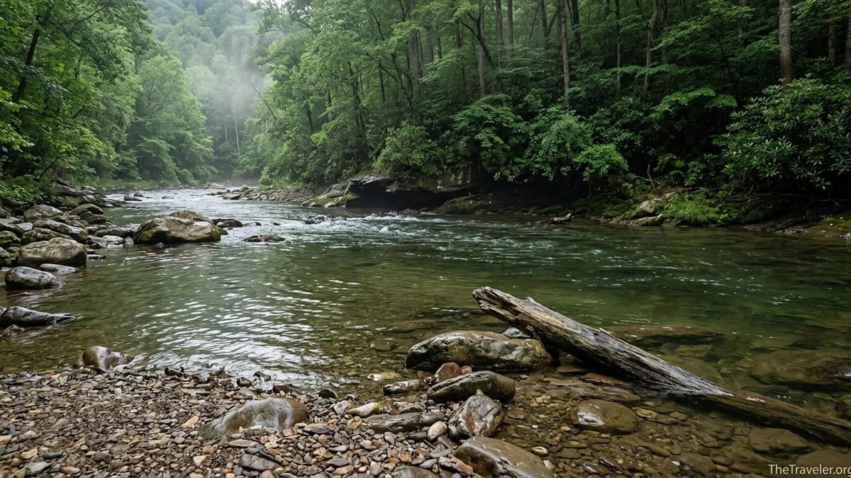
At first glance, Abrams Creek in Great Smoky Mountains National Park looks like the definition of mountain serenity. The water slides past limestone banks in glassy green sheets, anglers stand knee-deep in slow pools, and kids dabble their toes at the edge of gravel bars. Yet park rangers, local guides, and grim accident reports tell a different story. On this creek, conditions shift quickly. Water that seems calm at noon can become a churning, debris-filled force an hour later, and placid pools can hide currents strong enough to knock down a confident swimmer. Understanding why that happens, and how to read the signs, is essential for anyone planning to camp, fish, wade, or hike along Abrams Creek.
Get the latest updates straight to your inbox!
Abrams Creek: A Quiet Corner With a Complex Personality
Abrams Creek flows through the western side of Great Smoky Mountains National Park in Tennessee, feeding both popular backcountry fisheries and family campgrounds before emptying into Chilhowee Lake. For many travelers, the introduction to Abrams Creek is visual: a ribbon of clear water bordered by sycamores and rhododendrons, with shallow riffles that look more like a lazy backyard stream than a backcountry hazard. Park literature highlights its trout fishery and the small Abrams Creek Campground, reinforcing the impression of a mellow mountain waterway.
Hydrologically, though, Abrams Creek is anything but simple. The stream is underlain by limestone in sections, which creates spring-fed reaches with relatively stable base flows, and then transitions to steeper gorge segments where the gradient tightens and boulders constrict the current. That mix is part of what makes the watershed so productive for aquatic life, but it also means the character of the creek changes markedly from bend to bend. A 20-meter stretch that looks ideal for kids to splash can be followed immediately by a chute where the current accelerates and reverses beneath the surface.
Visitors also experience Abrams Creek in distinct zones. Upstream, near Cades Cove, the main hiking route to Abrams Falls parallels the creek and delivers hundreds of people a day to a large plunge pool that often looks inviting for a swim. Downstream, near the Abrams Creek Campground off Foothills Parkway, anglers and paddlers encounter a broader, more open channel where the flow appears slower and safer. In both places, however, the same rule applies: surface appearances do not reveal what the water is actually doing underneath.
Layered onto this complexity is the Smokies’ weather. Storms can build quickly over the high ridges, dropping intense rain that channels into side hollows and then into Abrams Creek, sometimes in less time than it takes to finish a picnic. When that happens, the entire feel of the creek shifts: water that was ankle deep over gravel can rise to mid-thigh, and the color, clarity, and sound of the current all change in ways that demand a traveler’s attention.
When Calm Water Turns Dangerous: How Abrams Creek Changes
To understand why the water in Abrams Creek can look calm yet behave violently, it helps to think about volume and constriction. On an average summer afternoon, you might see children wading near the bank while an angler stands comfortably mid-stream. The surface may show only gentle ripples. Yet even in those conditions, the creek is moving hundreds of gallons of water every second. When a thunderstorm drops heavy rain on the high country around Cades Cove, that volume increases rapidly and funnels into the same channel.
As the discharge rises, the current accelerates first in the deeper threads, then across the full channel. A rock garden that previously showed half a dozen stone tops might disappear entirely under chocolate-brown water. That new depth can trick people into thinking that conditions are safer for tubing or swimming because there are fewer rocks to hit. In reality, the opposite is true. Fast, deeper water creates hydraulics that can hold a person underwater, especially near drops, logs, or tight bends in the creek.
Travelers sometimes underestimate how quickly these shifts happen. Anglers who checked the weather in Townsend or Maryville in the morning may enter Abrams Creek in apparently friendly conditions, only to realize an hour or two later that the water has become pushy and discolored. Even a rise of a few inches can be critical. In mountain streams, a modest bump in level can double the force of the current, which is why experienced local guides watch not just rain forecasts, but also real-time gauge data for nearby rivers and visual cues such as water clarity and the speed of bubbles moving downstream.
This dynamic is not unique to Abrams Creek, but the creek’s popularity makes the consequences more visible. Over the years, a number of drownings and near-misses in the Abrams Falls area have involved people who entered what looked like a calm pool, only to be pulled unexpectedly by strong currents underneath the surface or pushed toward slick rocks near the lip of the falls. While these incidents are concentrated at the plunge pool, the same physics apply along the rest of the stream whenever flows spike.
Hidden Hazards Beneath a Glassy Surface
Much of the danger in Abrams Creek stems from things you cannot see from the bank. Even on a sunny afternoon, with the creek running clear and low, there are undercut banks, submerged boulders, and strainers that turn otherwise placid sections into technical water. A strainer is any object that allows water to pass through but can trap a person or gear: think of a fallen tree trunk wedged at a bend, with branches extending underwater just below the surface. On Abrams Creek, entire root balls can be pinned in the channel after high water, creating powerful sieves.
At typical warm-season levels, these strainers might be obvious only to a trained eye. A small disturbance in the surface or a patch of slightly foaming water can be the only indication that a branch ts beneath the flow. During higher water, those same hazards are completely invisible. A swimmer, tuber, or wading angler who gets swept toward them can be pinned by the current and held underwater, even in what appears to be flatwater.
Another hidden hazard is the uneven creek bed. Because Abrams Creek receives water from springs, seeps, and tributaries that carry varied sediment loads, its bottom is a mix of cobbles, slick bedrock, and deep pockets filled with gravel. Walk three steps on ankle-deep gravel, and the fourth may drop you unexpectedly into a thigh-deep hole. Add a bit of current, algae-slick stones, and a fishing pack on your back, and a simple stumble can turn into a struggle to regain footing while the water pushes you downstream.
Temperature adds yet another layer of complexity. Even in July, with daytime highs in Cades Cove in the 80s Fahrenheit, Abrams Creek can run surprisingly cold in its shaded sections. A traveler who jumps in for a quick swim may experience cold shock, an involuntary gasp and rapid breathing that makes it harder to stay calm and keep their head above water. Combined with an unexpected current or submerged obstacle, that shock response has contributed to more than one close call in similar mountain creeks across the Smokies.
Real Incidents, Real Lessons for Travelers
Safety discussions often resonate more when connected to actual events. The Smokies have seen numerous water-related fatalities over the decades, and a significant number have occurred in the broader Abrams Creek and Abrams Falls area. In several well-documented cases, otherwise capable swimmers were drawn toward the base of Abrams Falls, where a deceptively calm surface masked violent recirculating currents. Once in the hydraulic, they struggled to escape as the water repeatedly pushed them under and back toward the rock face.
Other incidents have involved slips from rocks and ledges around the creek. Visitors frequently climb wet boulders near the falls or along narrower gorge sections to pose for photographs or jump into pools. Park rangers regularly report rescues of people who lost their footing on polished, algae-coated rock and were swept into deeper water while disoriented from the fall. The rocks can be slick even on dry days because they are polished by constant flow and spray.
Flashier, less publicized events happen during and after major storms. In heavy rain, park managers have temporarily closed access roads like the Cades Cove Loop due to high water and localized flooding, partly because creeks that are normally benign become unpredictable. Local anglers share stories of arriving after a line of thunderstorms only to find tributaries like Abrams running high, brown, and littered with floating branches. On such days, even wading with a staff can feel precarious, and experienced Smoky Mountain guides cancel trips outright rather than risk being surprised by a further rise in flow.
For travelers, the takeaway from these real-world examples is not to avoid Abrams Creek entirely, but to treat it with the same respect you would a more obviously rough river. Every summer, people arrive expecting a gentle swimming hole, only to discover too late that the creek plays by mountain rules. Listening to rangers, reading posted warnings, and taking the time to observe the water before entering are simple, practical habits that could have changed the outcome in many of these cases.
Staying Safe: Practical Tips for Campers, Hikers, and Anglers
For campers at Abrams Creek Campground, the creek is both a backdrop and a temptation. It is common to see families setting up camp chairs on gravel bars or letting children wade at the edge while dinner cooks. A practical starting point is to establish clear rules the moment you arrive: children only near the water with an adult literally within arm’s reach, no one climbing on wet boulders, and no swimming when the water looks off-color or is running higher than the rocks you see in typical park photos and brochures.
Hikers planning the popular Abrams Falls Trail should treat the plunge pool and surrounding rocks as a place to view, not a water park. Wear grippy, closed-toe footwear instead of sandals if you think you may approach the water’s edge, and resist the urge to wade across the pool or jump from side ledges. Many travelers find that simply sitting a safe distance back from the edge with a packed lunch, watching the power of the falls and the swirling currents below, is more rewarding than risking a quick dip in water that has a known history of accidents.
Anglers on Abrams Creek commonly wear chest waders or wet-wading gear and a fishing pack. The combination of extra weight and moving water is exactly what rescue professionals worry about. Before stepping in, pick a point on the opposite bank and watch how quickly foam and leaves drift past it. If it looks faster than a casual walking pace, treat that stretch as off-limits for wading. Use a wading staff, keep your pack’s hip belt unfastened so you can shed it quickly, and angle upstream as you move, keeping at least two points of contact with the bottom at all times.
Across all user groups, one recommendation is consistent: wear a properly fitted personal flotation device whenever you are in or very near the water, especially if you are supervising children or moving on uneven banks. While it may feel out of place to wear a life jacket in what looks like a waist-deep pool, the force of moving water is often underestimated. A simple, low-profile hiking or fishing PFD can make the difference between a scare and a tragedy when conditions change suddenly.
Reading the Creek: Field Checks Before You Go In
Before anyone in your group steps into Abrams Creek, it pays to take five to ten minutes to “read” the water. Start by looking upstream as far as you can. Do you see any recent deposits of branches along the banks, or logs caught across the channel? These can indicate how high the water has been recently and hint at hidden strainers under the surface. Note the water color: typical Abrams Creek runs clear to greenish; if it looks muddy or opaque, flows upstream may be elevated, and more water could be on the way.
Next, watch for changes in current speed across the channel. Calm-looking surface water can still be moving fast; one quick test is to toss a small stick or leaf in and count how many seconds it takes to pass a visible rock or root on the bank. If it covers several body lengths in just a few seconds, that current will be stronger than it appears, especially where the channel narrows. Avoid sections where the water surges around outside bends, as the current there tends to feed into undercut banks and submerged obstructions.
Scan the banks for damp lines or stranded debris that sit well above the current water level. These “high water marks” show where the creek ran during recent surges. If those lines are fresh, with still-green leaves or newly exposed sand, interpret that as a clue that the creek can rise quickly after rain, and be particularly cautious if storms are forecast. Finally, listen: a low rumble or roar upstream can signal more volume moving toward you than the surface at your spot suggests.
If any of these checks raise concerns, choose a different activity for the day. Swap a planned swim for a creekside walk, or move your fishing to a smaller, more stable tributary. One of the advantages of the Smokies is the sheer number of alternative streams and trails. It is rarely worth insisting on entering Abrams Creek if your observations and the forecast suggest that its mood is shifting.
The Takeaway
On a map or in a quick snapshot, Abrams Creek does not look like a dangerous river. It is not lined with big whitewater rapids, and in its lower reaches it often drifts past gravel bars that invite bare feet. The reality, revealed by hydrology and history, is more complex. This is a mountain creek whose water level and character can change rapidly due to storms, whose apparently calm pools may conceal fast currents and underwater obstacles, and whose polished rocks turn small missteps into potentially serious incidents.
For travelers, the goal is not to avoid Abrams Creek, but to meet it with an informed respect. Arrive with the same mindset you would bring to any backcountry environment: conditions can change; local knowledge and park guidance matter; and your own observations are as important as any plan you made at home. Build in habits such as watching the water before entering, using life jackets near moving current, and setting clear boundaries for children. Pair those with an appreciation for the creek’s ecological richness and quiet beauty, and you can enjoy Abrams Creek safely while giving its fast-changing character the space it demands.
In the end, the calm water of Abrams Creek is part of its allure, reflecting clouds, trees, and the high ridges of the Smokies. Remember that this surface calm is only one layer of the story. Beneath it, the creek is always in motion, responding to storms, seasons, and terrain. Recognizing that living, changing nature is the key to experiencing Abrams Creek not just as a pretty backdrop, but as a powerful mountain waterway that deserves your full attention.
FAQ
Q1. Is it safe to swim in Abrams Creek or at Abrams Falls?
Swimming is not recommended at the base of Abrams Falls or in fast-moving sections of Abrams Creek because strong currents, underwater rocks, and hidden hydraulics have contributed to past drownings and serious accidents, even when the surface looked calm.
Q2. How quickly can water levels in Abrams Creek rise after a storm?
Levels can begin to rise within an hour or less after heavy rain in the surrounding mountains, especially after intense summer thunderstorms, so a seemingly gentle creek in the morning can become higher, faster, and more hazardous by afternoon.
Q3. Are children allowed to play in Abrams Creek near the campground?
Children are not prohibited from wading near the campground, but adults should keep them within arm’s reach, avoid slick rocks and deeper current, and pull them back from the water entirely if flows become discolored, faster, or begin to rise.
Q4. Do I need a life jacket if I am only wading or standing near the bank?
While not legally required for wading, wearing a properly fitted life jacket is strongly advised for anyone entering moving water or supervising children, because even a shallow, fast current can knock an adult off balance and sweep them downstream.
Q5. How can I tell if the current in Abrams Creek is stronger than it looks?
Watch how fast leaves or small sticks drift past a fixed point, look for water piling up against rocks or outside bends, and avoid entering if the current appears faster than a casual walking pace or if you see standing waves or swirling eddies where the channel narrows.
Q6. What footwear is best for walking along or in Abrams Creek?
Closed-toe shoes or sturdy water shoes with good grip are best, since algae-coated rocks and slick bedrock can cause falls; flimsy flip-flops or loose sandals increase the risk of slipping or losing footwear in the current.
Q7. Is tubing recommended on Abrams Creek?
Tubing is generally discouraged on Abrams Creek because of cold water, variable flows, submerged obstacles, and limited exit points; nearby lakes or designated swimming areas are safer options for floating with children or inexperienced swimmers.
Q8. Are there specific signs or warnings I should look for at Abrams Creek?
Pay close attention to any National Park Service safety signs at trailheads, parking areas, and near the water, especially warnings about slippery rocks, swift currents, and the dangers of climbing around Abrams Falls or entering the plunge pool.
Q9. What should I do if a storm is forecast during my visit?
If storms are likely, plan to stay out of the creek, keep your campsite well above the waterline, avoid parking close to low banks, and treat any sudden increase in flow, noise, or turbidity as a cue to move farther from the channel.
Q10. Can I still enjoy Abrams Creek if I do not go in the water?
Absolutely; many visitors choose to hike along the creek, picnic on high gravel bars, photograph the water and surrounding forest, or watch wildlife such as kingfishers and herons, all while staying safely back from the edge and respecting the creek’s changing character.