


My plan had been simple: a couple of nights at a Bureau of Land Management campground near Indian Creek, a quick detour into the Needles district of Canyonlands, and then on to Moab. What actually unfolded was one of my favorite Utah adventures to date, an unhurried loop that linked red-rock desert camping beneath world-famous cliffs with a quiet retreat in the cool forests of the nearby Abajo Mountains. Camping near Indian Creek did not just deliver spectacular scenery; it showed me how varied, fragile, and rewarding this corner of Bears Ears National Monument can be when you give it time.
Get the latest updates straight to your inbox!
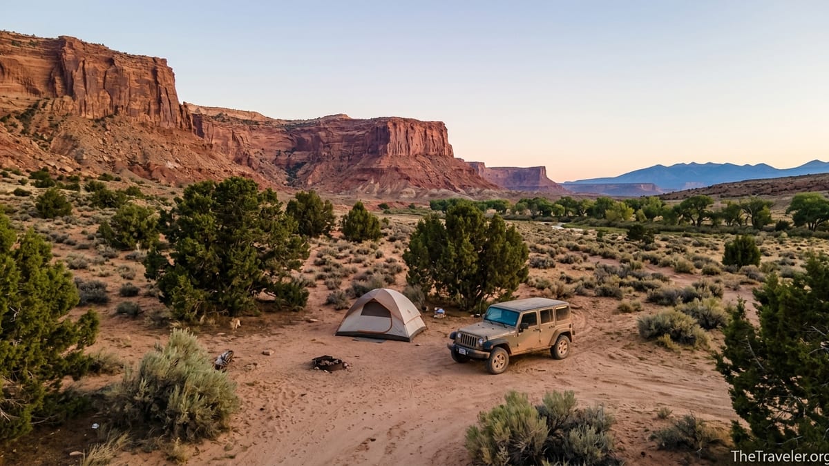
Finding Indian Creek: Where the Desert Opens Up
Indian Creek sits along Utah Highway 211 between U.S. 191 and the Needles district of Canyonlands National Park, in the northern unit of Bears Ears National Monument. Driving in from the junction with U.S. 191, the landscape changes quickly. Low sage and piñon give way to towering walls of Wingate sandstone, the famous splitters where climbers from around the world come to test their skills. The road winds gently along the corridor, passing classic formations like the Six-Shooter Peaks and the subtly greener ribbon of cottonwoods that marks the actual creek.
Because this is a remote stretch of southeastern Utah, services are minimal by design. There is no fuel, no restaurants, and no grocery store between the U.S. 191 turn-off and the Needles entrance station. The nearest full services are in Moab to the north and Monticello to the south, both roughly an hour or more away by car depending on your starting point. That reality shapes every camping decision here. You bring in your own water, food, and firewood, and you pack everything back out again.
On my first visit, I underestimated how quickly the day would disappear as I stopped at Newspaper Rock to examine the panel of petroglyphs and lingered at overlooks along 211. By late afternoon, golden light poured across the buttes and it became clear I needed a place to camp sooner rather than later. Indian Creek’s mix of established campgrounds and carefully managed dispersed sites suddenly mattered a lot.
That first scramble to find a site ended up being a blessing. It forced me to understand the layout of the corridor: where the campgrounds actually sit in relation to climbing areas, how far they are from Canyonlands, and where the road begins to climb into the national forest. The geography of Indian Creek looks simple on a map, but once you are on the ground the distances feel longer and the options more nuanced.
Choosing a Campsite: From BLM Campgrounds to Dispersed Sites
There are two primary ways to camp near Indian Creek: at one of the established BLM campgrounds in the monument or at a dispersed site on surrounding public lands. The main campgrounds along the corridor are Hamburger Rock, Superbowl, and Creek Pasture, all managed by the Bureau of Land Management. Each sits in its own pocket of terrain, with views that range from close-up sandstone walls to wider vistas of the desert basin and the Abajo Mountains beyond.
On my first night I rolled into Superbowl Campground, a sandy bench south of Highway 211 accessed by a short dirt road. Sites are spread across open desert with scattered juniper, and most have excellent views toward the cliffs that make this area so famous. The fee, like Creek Pasture and Hamburger Rock, was in the ballpark of 15 dollars per night, payable on-site by cash or via the Recreation.gov Scan & Pay option using a phone signal strong enough to upload a transaction when I passed back through service. Reservations are not available for regular sites here, so everything operates on a first-come, first-served basis.
Group sites are a separate story. If you are traveling with a large climbing crew or extended family, special group areas at Superbowl, Creek Pasture, and the Indian Creek Falls area can be reserved ahead of time, typically accommodating up to around 50 people for a higher nightly fee. On one trip I watched a guided climbing group settle into the Superbowl group site with coordinated shade tents, a communal kitchen, and a cluster of vans. For them, a reserved site meant not having to race the Friday evening rush down from Moab.
Beyond the campgrounds, dispersed camping is allowed in designated zones around Indian Creek, especially as the landscape transitions toward the national forest. The BLM and Forest Service emphasize camping in previously disturbed spots, at least roughly 150 feet off designated routes and well away from water sources. In practice that means pulling into obvious dirt clearings with existing fire scars instead of creating new drives or pushing your vehicle into fragile crust. On one afternoon I explored a spur road north of the corridor and found a quiet site on a low knoll scattered with sage and cryptobiotic soil. The view toward the Needles was stunning, but the delicate black crust underfoot was a clear reminder to tread carefully and keep the car firmly on disturbed ground.
Life at Camp: Sunsets, Stars, and Desert Practicalities
Evenings at an Indian Creek campsite revolve around light. Late in the day, the sandstone walls flare from dull orange to neon copper, then gradually fade as shadow fills the basins. At Creek Pasture Campground, where cottonwoods line a shallow drainage, I watched the last rays catch the tops of skeletal branches while the canyon floor fell quickly into dusk. A pair of climbers returned to their site with tape gloves still on, headlamps dangling from their harnesses, and the smell of someone’s dinner drifted through the still air.
After dark, the sky takes over. There is almost no artificial light in the corridor, so the Milky Way rises sharp and bright on clear nights. Lying on my back outside the tent at Hamburger Rock, I could see satellites tracking slowly across the sky and the hazy band of the galaxy arcing from horizon to horizon. With temperatures dropping quickly after sunset, I was glad for a 20-degree sleeping bag even in shoulder season. In mid-spring and late fall, nighttime temperatures often slip close to freezing despite daytime warmth.
Practicalities at camp matter as much as the romance of sunsets. The BLM campgrounds provide vault toilets and metal fire rings, but no potable water, no trash service, and no hookups. On my last trip I filled water jugs at a gas station in Monticello and carried every drop I would need for several days of camping and hiking. That meant budgeting roughly four liters per person per day in cool weather, more in the heat, plus extra for cooking and dishwashing. Trash rode in a sealed bin in the back of the car until I could dispose of it properly back in town.
Fire rules change with conditions, particularly in late spring and summer when wildfire risk jumps. On one visit, fire restrictions meant I skipped the campfire entirely and relied on a backpacking stove for cooking and a headlamp for evening light. It felt odd at first, but the quiet glow of the stars more than compensated, and I was reminded how quickly a single careless ember could damage the fragile desert beyond my circle of light.
From Sandstone to Ponderosa: Escaping to the Abajo Mountains
What turned my Indian Creek camping trip into a favorite Utah adventure was the realization that I did not have to choose between desert and forest. A short drive up the road beyond the corridor carried me into the Abajo Mountains, part of the Manti-La Sal National Forest. As Highway 211 climbs, slickrock benches give way to piñon and juniper, then to ponderosa pines and aspen groves. The temperature drops noticeably with each mile and each thousand feet of elevation gain.
One afternoon, after a hot morning exploring side canyons, I turned off the pavement onto a graded forest road signed for Elk Ridge. Recent weather had left it dry and easily passable for a standard SUV, though ruts and washboarding meant driving slowly. A few miles in, the desert views opened up behind me while grassy clearings and stands of fir appeared on either side of the track. It felt like I had been transported to a different state entirely, despite being only an hour or so from where I had camped the night before.
The national forest above Indian Creek offers its own network of primitive campgrounds and dispersed sites. These are especially appealing in midsummer when temperatures on the canyon floor can become exhausting by mid-morning. On one July trip, I planned a two-tiered approach: a night in the forest at around 8,000 feet where the air was cool enough for a light jacket in the evening, then a day-trip down to Indian Creek for hiking and photography before returning to the trees to sleep. It felt like cheating the heat without ever leaving the region.
Camping in the forest comes with a different set of considerations. Afternoon thunderstorms are more common at higher elevations, and roads can become muddy or temporarily impassable after heavy rain. Wildlife sign is more obvious, from deer tracks in the dust to the occasional bear claw marks on a distant tree. On my last visit I stored food as if in any mountain environment, keeping coolers in the vehicle overnight and avoiding leaving anything scented in the tent.
Exploring Beyond Camp: Cliffs, Petroglyphs, and Quiet Roads
Camping near Indian Creek is as much about how you spend your days as where you lay your head at night. Climbers know this corridor for its endless crack lines, from easier classics to notoriously difficult test pieces. Even if you never tie into a rope, it is worth walking to the base of a popular wall just to appreciate the geometry up close. On one rest day I hiked along the base of Supercrack Buttress, watching chalked hand jams disappear into the sky and listening to the muted clink of climbers re-racking gear on ledges far above.
For non-climbers, the red-rock corridor holds plenty of subtler pleasures. Short walks lead to viewpoints across the valley, and side canyons invite day hikes where you follow sandy washes between walls that rise higher with each bend. Early or late in the day, the light slants just right to emphasize every ripple in the sandstone. I spent a full morning exploring one unnamed side drainage, tracing petrified ripples in the rock and sitting quietly while ravens played in the thermals overhead.
Cultural sites add another dimension to time spent here. Newspaper Rock, located along Highway 211 on the approach to Indian Creek, presents a dense panel of petroglyphs carved into varnished sandstone over many centuries. On my first pass I stopped for a quick photograph; on the second, I stayed long enough to notice how older, darker images intermingle with newer, lighter etchings. Visiting these sites while camping nearby drives home how long people have moved through this landscape and how recent our tents and vans really are in the grand timeline.
Driving the backroads becomes part of the experience, too. Both the BLM and the Forest Service maintain networks of designated routes that branch away from the main highway. Many are suitable for high-clearance passenger vehicles in dry weather, though conditions can change quickly with rain or snow. On one evening I followed a graded road out toward a low mesa and found an informal pullout perfectly oriented for sunset photography. The return drive in full dark, with distant flashes of heat lightning on the horizon, was one of the most atmospheric moments of the trip.
Planning, Safety, and Respect for a Fragile Place
Success in camping near Indian Creek depends on planning around remoteness. Before leaving Monticello or Moab, I now top off the gas tank, fill every water container, and double-check that I have enough food for at least one extra night. Cell coverage is spotty to nonexistent in much of the corridor, so I download maps for offline use and let someone at home know my rough itinerary. Breakdowns and minor mishaps become much more manageable when you have a cushion of supplies.
Weather is another key factor. Spring and fall bring some of the most pleasant temperatures, but they can also deliver sudden storms that drop rain or even snow on the higher terrain. In late spring, I have woken to frost-crusted tents at Creek Pasture, then spent the afternoon hiking in T-shirts under a warm sun. Summer heat can be intense in the canyon, especially in July and August, when daytime highs often reach into the upper 90s Fahrenheit or higher. On those trips, early starts and midday siestas in the shade or up in the forest became non-negotiable.
Respect for restrictions and cultural values is essential here. Seasonal raptor closures can affect certain climbing walls, and signage along the corridor asks visitors to avoid specific areas when birds are nesting. Fire restrictions shift with drought conditions, and camping rules continue to evolve as visitation grows. On my most recent trip I stopped at the visitor information desk in Monticello to check current guidance on where dispersed camping was encouraged and where new closures had been put in place to protect resources.
Simple Leave No Trace habits matter more than ever in a place that feels this wild yet is seeing increasing use. I travel with a portable toilet system when dispersed camping away from vault toilets, pack out used toilet paper in sealed bags, and treat any fire ring I use as a privilege rather than a right. On one morning walk through a popular informal site, I filled a bag with stray bottle caps and micro-trash. It took ten minutes and cost nothing, but it felt like paying back a small part of the debt owed to the landscape that had hosted me so generously.
The Takeaway
What makes camping near Indian Creek one of my favorite Utah adventures is not a single viewpoint or one perfect campsite. It is the combination of elements that come together in a relatively compact area: world-class desert scenery, a sense of deep cultural time, manageable but very real remoteness, and the chance to pivot between sun-baked slickrock and cool mountain forest in the span of a single day.
In practical terms, this is a place where a solo traveler in a modest vehicle can claim a simple site at a BLM campground, fall asleep under a sky dense with stars, then wake to explore side canyons in near solitude. It is a corridor where a van full of climbers can spend a week chasing cracks by day and cooking communal dinners by headlamp at night. It is also a region where families can split their time between the paved overlooks of Canyonlands and gravel roads that lead to quiet forest clearings.
If you arrive prepared to be self-sufficient, flexible about exactly where you camp, and attentive to evolving regulations, Indian Creek and its surrounding high country will reward you with much more than a place to pitch a tent. For me, it reshaped the way I think about southeastern Utah, revealing a vertical slice of desert-to-forest life that keeps pulling me back. Each time I head down Highway 211 and see those sandstone walls begin to rise, it feels less like driving into a destination and more like returning to a favorite neighborhood in a very wild town.
FAQ
Q1. Do I need a reservation to camp near Indian Creek? No, standard sites at BLM campgrounds like Superbowl, Creek Pasture, and Hamburger Rock are first-come, first-served, though group sites can be reserved in advance.
Q2. Is there potable water available at the Indian Creek campgrounds? No, there is no potable water at the BLM campgrounds in the corridor, so you should bring all the water you need or refill in towns like Moab or Monticello.
Q3. What is the best season for camping near Indian Creek? Spring and fall are generally the most comfortable, with cooler temperatures and fewer thunderstorms, while summer can be very hot on the canyon floor and winter can bring snow and icy roads.
Q4. Can I have a campfire at my site? Sometimes, but it depends on current fire restrictions; even when fires are allowed, you should use existing fire rings in established campgrounds or follow Leave No Trace practices at dispersed sites.
Q5. Is dispersed camping allowed near Indian Creek? Yes, dispersed camping is permitted in certain areas on BLM and nearby national forest lands, typically in previously disturbed sites a short distance off designated roads and away from water sources.
Q6. How far is Indian Creek from the Needles district of Canyonlands National Park? The Indian Creek corridor lies along Highway 211 roughly 30 to 45 minutes from the Needles entrance by car, depending on your campsite location, road conditions, and stops along the way.
Q7. Do I need four-wheel drive to reach the campgrounds? No, the main BLM campgrounds are usually accessible via graded dirt roads suitable for most passenger vehicles in dry conditions, but high clearance or four-wheel drive can be helpful for some dispersed sites and after storms.
Q8. Are there any stores or gas stations near the campgrounds? No, there are no services in the immediate corridor; the closest fuel, groceries, and other supplies are in Moab or Monticello, so plan to arrive fully stocked.
Q9. Is it safe to camp alone in this area? Many solo travelers camp here, but you should be self-reliant, carry adequate supplies, keep someone informed of your plans, and be prepared for limited cell coverage and changing weather.
Q10. How can I minimize my impact while camping near Indian Creek? Stay in existing sites, pack out all trash and waste, respect closures and cultural sites, avoid driving or walking on fragile soil crusts, and follow current fire and camping regulations posted by land managers.