


By the time I realized how quickly the river was rising at Charco El Hippie, my shoes, backpack, and exit route were already underwater. I had come to Naguabo expecting a quiet swim and some petroglyphs. I left with a deep respect for how beautiful and unforgiving this corner of Río Blanco can be, especially after the October 2026 flash-flood warning that specifically named this river.
Get the latest updates straight to your inbox!
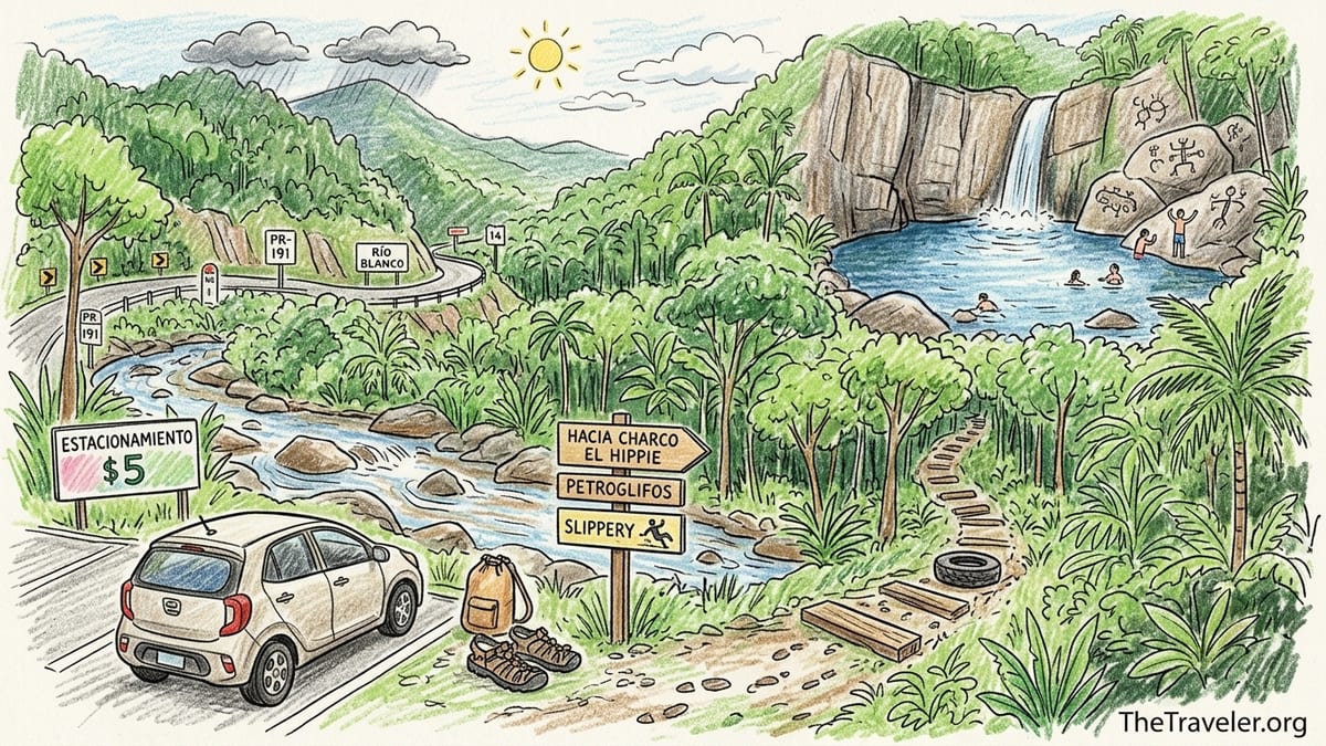
Getting to Charco El Hippie: The Exact Route I Drove
I visited Charco El Hippie in early October 2026, a few days after the National Weather Service issued a flash-flood warning for Naguabo that cited Río Blanco among the affected locations. I started from San Juan in a compact rental car and took the most common east-coast route: PR-26 toward Carolina, then PR-66, merging onto PR-3 heading southeast along the coast. Near the town of Río Grande I stayed on PR-3 rather than entering the main El Yunque entrance, then continued south until intersecting PR-31, the inland road that climbs toward Naguabo’s Río Blanco and Cubuy sectors.
From PR-3, I turned onto PR-31 toward Naguabo’s interior. This section immediately felt more rural: fewer gas stations, narrow shoulders, and more sharp curves. PR-31 eventually meets PR-191 south, the mountain road that skirts the southern side of El Yunque and passes Río Blanco. I turned onto PR-191 and followed it uphill, watching the kilometer markers and small local signs for Río Blanco and Cubuy. Cell service faded in and out here, so I was glad I had offline maps downloaded in advance and the coordinates saved in my phone notes rather than relying on a live signal.
As I climbed, roadside houses thinned out, replaced by thick forest and glimpses of the river far below. Charco El Hippie is not marked by a big official sign. What I saw first was the tall rock wall through a break in the trees and a cluster of cars pulled onto the right-hand shoulder of PR-191 near a bend in the road. There were also a couple of hand-painted boards mentioning parking and food in Spanish. If you are coming from the coast like I did, the access will be on your right; if you are coming from the interior side of Naguabo, it will be on your left before the road climbs higher into the hills.
The entire drive from San Juan took me about one hour and forty minutes with no major traffic, including a quick stop for water and snacks at a supermarket along PR-3 near Humacao. I would not attempt this drive in a hurry or after dark if it is your first time. The combination of mountain curves, patchy pavement, and occasional fog or showers near El Yunque makes daylight and unhurried driving the safest choice.
Where I Actually Parked and What It Cost
Parking is one of the first decisions you will have to make at Charco El Hippie, and there are trade-offs between convenience, security, and cost. When I arrived on a Saturday late morning, I saw several cars parked informally along the narrow shoulder of PR-191, and I also noticed an open gate on the river side of the road with a simple sign indicating paid parking. I chose the paid option because the official documents about Destino 191 and community plans for this area mention past issues with cars parked haphazardly along the road and occasional thefts from vehicles left in informal spots.
Inside the gate, a local attendant directed me to park on a grassy, leveled clearing set back from the road. The fee that day was 5 US dollars in cash, collected per vehicle, not per person. There was no printed ticket, just a verbal confirmation and a mental note of my rental’s license plate. The area was not paved, but it felt more secure than leaving the car on the thin shoulder, where a passing truck or careless driver could clip a mirror. A couple of other visitors told me they preferred the paid lot for the same reasons, especially when leaving bags or dry clothes locked in the car.
From my parking spot, the path toward the water started right behind the lot and dropped gently toward the river. This saved me from having to scramble down the steeper embankments you see next to some of the free roadside parking. If you choose to park for free along PR-191, make sure your vehicle is entirely off the pavement and not blocking driveways or narrowing the lane. The road is used not only by tourists but also by local residents and delivery trucks, and blocking it can lead to towing or conflicts with the community.
I checked the time on my phone when I closed the car door. From locking the car in the paid lot to standing at the edge of the main pool took me just under ten minutes at an easy walking pace. That short walk, however, gave me a first preview of what the rest of the terrain would be like: damp ground, uneven rock, and a lot of places where ordinary flip-flops would have been a problem.
The Walk In: Trails, Stairs, Mud, and Slipperiness
Charco El Hippie does not have a long approach, but it is not a groomed urban park either. The first part of the walk from the paid lot was a dirt path with exposed roots and some homemade wooden steps reinforced with discarded tires and stones. After the recent rains that had triggered the October flash-flood warning, the ground was soft and in places actively muddy. Each step down required attention, especially where the path narrowed between tree trunks or where water had carved small ruts.
About halfway down there was a concrete stair section, built more solidly than the improvised wood steps but stained dark with constant moisture and algae. These stairs led to a wider landing area above the main pool with a decent view of the towering rock wall and the waterfall. The concrete itself was not broken, but every edge felt slick. I had trail sandals with a grippy sole and still found myself testing each step with my weight centered and one hand brushing the wall or a nearby trunk.
Closer to the water, the trail dissolved into open rock and scattered boulders. The large granite-like slabs that frame the pool were still damp from overnight drizzle, and the combination of smooth stone and fine sand tracked from the path meant many surfaces were like walking on wet glass. There were no railings near the water, only natural ledges and a few roots to brace against. This is where I saw the first reminder of how serious a slip could be: a visitor sitting with an ice pack on his shin where he had slid on the rock while trying to climb up for a better view.
If you are carrying small children, large bags, or any gear in your hands, expect this short approach to feel more complex than the distance would suggest. You will want at least one hand free at all times. I wore closed-toe hiking sandals and was glad I had not worn rubber flip-flops; a woman near me in simple beach slides ended up walking barefoot over much of the rock because her shoes had almost no grip when wet.
Water Depth, Current, and How the River Changed While I Was There
At the main pool directly below the large rock wall, the water was deep enough that stronger swimmers were jumping in feet-first from a modest height near the lower ledges, even without touching the bottom. While I cannot give an exact measurement, the central basin felt easily deep enough to submerge a standing adult. Closer to the edges, the depth dropped off quickly: knee-deep at the very margin, then waist-deep just a meter or two in. The river was clear but with a brown-green tint from the forest, and when I arrived around midday, the current near the pool itself was gentle.
Further upstream, above the main basin, the water flowed through narrower chutes and smaller cascades where the current was much stronger. In some places you could see white froth where water squeezed between rocks, and these were absolutely not places to underestimate if you are not a confident swimmer. Downstream from the main pool, the flow spread over broad rocks and smaller pools used mostly by families with children. Here the water was shallower and calmer, but the rock underneath was uneven and slippery, so every step still needed attention.
What surprised me was how much the river changed during a single visit. When I arrived, the sky over Naguabo was partly cloudy with patches of sun. El Yunque’s peaks, though, were frequently wrapped in darker cloud. About ninety minutes into my visit, I noticed two things at once: the distant sound of heavier water upstream and a slow but visible rise in the level at the edge of the main pool. A rock that had been a dry sitting spot when I arrived was suddenly half-covered, and the small sandy pocket where I had left my sandals was beginning to take on water.
This was not a catastrophic flash flood, but it was a clear example of how upstream rain you cannot see can still impact conditions at Charco El Hippie. I watched the waterline climb several centimeters over half an hour, and the current in the middle of the pool became noticeably stronger. That was my personal signal to start packing up. I moved my bag higher on the rock and encouraged another couple to do the same, then made my way back to the stairs before conditions forced a more slippery, urgent retreat.
Footwear, Bags, Phones, and What I Was Glad I Brought
If there is one thing I wish every visitor to Charco El Hippie understood before arriving, it is that proper footwear matters more here than almost any other piece of gear. I wore closed-toe hiking sandals with thick rubber soles and toe protection. They allowed me to walk the muddy trail, descend the concrete steps, and move on wet rock without feeling every sharp edge. Around me, the people who struggled the most were in smooth-bottomed flip-flops or bare feet. One man slipped while carrying a small cooler; another guest caught him just before he went over a ledge into waist-deep water.
I carried my phone in a basic waterproof pouch on a lanyard and kept my wallet and car key in a small roll-top dry bag inside a lightweight daypack. At one point, when the rising water lapped at the rocks where a group had left open bags and towels, I watched their belongings get soaked in minutes. My own pack was clipped to a higher branch, which kept it out of the unexpected splash zone when the current strengthened. At a minimum, I would recommend putting electronics in a sealed plastic freezer bag if you do not have dedicated waterproof gear.
As for larger bags and valuables, I left anything nonessential locked in the car in the paid lot. I brought only what I was comfortable keeping within arm’s reach: a microfiber towel, water bottle, a few snacks, sunscreen, and bug repellent. I saw no formal lockers or secure storage on site, so think of Charco El Hippie as a place where you travel light. Heavy beach bags and bulky coolers not only tire you out on the approach but also make it harder to move quickly if conditions change.
One more detail I appreciated having thought about in advance was a simple pair of inexpensive river gloves. The wet rocks often required using my hands to steady myself, and the rough surfaces were studded with smaller, sharp crystals. Gloves are not essential, but after feeling how abrasive the stone was when I reached for a handhold, I was glad to have that extra layer of protection.
Petroglyphs, Rock Formations, and Why I Skipped High Jumps
Charco El Hippie is as much about the rock as it is about the water. The towering face beside the main pool, streaked with mineral deposits and ferns, draws the eye as soon as you step out of the trees. Along one side of the river, smooth boulders form sheltered overhangs and small cave-like spaces. In some of these areas, higher up on flatter rocks, there are carved Taíno petroglyphs that have made this site famous among locals and visitors who appreciate Puerto Rico’s Indigenous heritage.
To reach the petroglyphs that I saw, I followed a narrow, partly worn path along the rocks on the side opposite the main concrete stairs. The route involved stepping over cracks, balancing on sloped stone, and occasionally using both hands to pull myself up a low ledge. The carvings themselves were on horizontal surfaces where hundreds of years of weather and lichen had softened the outlines but not erased them. Standing there, surrounded by forest sounds and river noise, it was not hard to imagine why Taíno communities chose this place for ceremonial art.
At the same time, the rock formations that make this place beautiful have also made it a magnet for risky behavior. Several promotional photos and older travel blogs show visitors leaping from high points on the rock wall or using rope swings tied to riverside trees. During my visit, rope swings were present, and a few people were climbing quite high to jump. I chose not to join them, following the same caution you will see in official tourism guidance across Puerto Rico that advises against high rock jumps or rope swings in river and waterfall settings because of hidden rocks, inconsistent depths, and the risk of spinal injuries.
Watching the scene as an outsider, it was clear that the margin for error was small. A misjudged flip or a slippery takeoff on wet rock could easily end with a head or back impact. The water, though deep in the middle, was not a uniform swimming pool; submerged boulders lurked closer to the edges. For me, the better choice was to enjoy the view from mid-level rocks, slide into the water from lower ledges where I could see the bottom, and leave the high jumps for people who were willing to take risks I was not.
Insects, Facilities, Weather, and When I Would Turn Around
Facilities at Charco El Hippie are basic to non-existent. During my visit, I did not see any formal changing rooms or restrooms near the main pool. Some of the small private businesses that operate parking and kiosks along PR-191 may offer bathrooms to customers, but right at the river’s edge you should not expect infrastructure. Most people changed into swimwear either at their car or discretely behind towels near the rocks. If you need a full changing room, plan to use one at your accommodation or at a beach facility earlier in the day.
Insects were present but not overwhelming when I arrived late morning. Mosquitoes were noticeable in the shaded, still sections of the trail and near puddles off the main path, especially when I stopped moving. Once at the open rocks by the water, a light breeze kept them down, but as soon as the clouds rolled in and the air turned more humid, I started feeling occasional bites again. I applied a standard DEET-based insect repellent before starting the descent and carried it with me, which made a noticeable difference. Sandflies were less of an issue for me, though I heard one local mention that late afternoon can be worse.
The bigger environmental factor, though, was the weather. On the morning of my visit, the forecast called for scattered showers near El Yunque and a lower but real chance of thunderstorms inland, consistent with the unsettled pattern that had produced the October 2026 flash-flood warning days earlier. On site, that translated to alternating sun and fast-moving cloud bands. I made a point of checking the sky not just above me but toward the higher ridges where Río Blanco and its tributaries begin.
My personal rule, especially after seeing the waterline creeping higher during my short visit, is to turn around and leave the river if I notice any combination of three things: dark, persistent clouds parked over the mountains; a quick change in water color from clear to noticeably brown or debris-filled; or a rise in water level that covers previously dry rocks in a matter of minutes. At Charco El Hippie, I saw one of those signs clearly and the beginnings of another, which was enough for me to get out before conditions deteriorated. If you have children, are not a strong swimmer, or are unfamiliar with mountain rivers, I would err on the side of leaving even earlier.
After packing up, the climb back to the parking lot felt steeper and more humid, but the trail was still manageable. Light rain began as I reached the car, turning the upper dirt section into a slicker, shinier brown surface. Driving back down PR-191 in that drizzle with fog forming around the bends confirmed that leaving when I did was the right call.
The Takeaway
Charco El Hippie in Naguabo is not a casual roadside dip; it is a powerful mountain river pool on Río Blanco with petroglyphs, rock formations, and an atmosphere that combines local weekend hangout with wilderness edge. The approach is short but slippery, the rocks are as unforgiving as they are beautiful, and the water level can change faster than many visitors expect, especially during the kind of unsettled weather that produced the October 2026 flash-flood warning in this very watershed.
What I wish I had fully understood before going is how many small decisions add up to a safe or risky day here: where you park, how much you carry, what you wear on your feet, whether you keep an eye on the upstream sky, and when you decide to call it and head back up the stairs. None of those choices can eliminate the risk entirely, but they can radically shift your odds of going home with only wet clothes and good memories.
If you are planning a visit, download maps before you leave, bring sturdy water-friendly shoes, protect your phone and keys from water, assume there will be no changing rooms, and treat every rock and trail step as potentially slick. Enjoy the petroglyphs and views, but be ready to skip the high jumps and rope swings, especially after rain. Listen to local advice, watch the river like you would watch the ocean for rip currents, and remember that turning around early is always an option you will be glad to have kept on the table.
FAQ
Q1. How long does it take to walk from the parking area to Charco El Hippie?
The walk from the paid parking lot I used to the main pool took about 10 minutes at an easy pace, including time to navigate muddy sections, concrete steps, and wet rocks.
Q2. Is there an entry or access fee for Charco El Hippie?
There was no official entry fee for the river itself during my visit, but I paid 5 US dollars in cash to park in a privately operated lot near the trailhead rather than leaving the car on the road shoulder.
Q3. What kind of footwear is best for Charco El Hippie?
Closed-toe hiking sandals or water shoes with good traction work best. Flip-flops and smooth-soled slides performed poorly on the wet concrete stairs and algae-covered rocks, and I saw several people slip in them.
Q4. How deep is the water and is it safe to jump from the rocks?
The central basin of the main pool was deep enough that I could not touch bottom, but depth varied near the edges. Because of hidden rocks and changing water levels, I chose not to jump from high rocks or use rope swings, following official safety advice that warns against these activities.
Q5. Are there bathrooms or changing facilities at Charco El Hippie?
At the river itself I did not see formal bathrooms or changing rooms. Most people changed at their vehicles or used towels for privacy on the rocks. Any restroom access is likely to be through nearby private businesses, not at the pool.
Q6. What was the weather like during your visit, and how did it affect the river?
I visited on a day with alternating sun and clouds following an October 2026 flash-flood warning for Naguabo. While the weather at the pool seemed mild at first, upstream rain raised the water level several centimeters in under an hour and strengthened the current, which led me to leave earlier than planned.
Q7. Did you encounter many insects, and should visitors bring repellent?
Mosquitoes were noticeable on the shaded trail and near standing water but less intense on the open rocks. I used a DEET-based repellent and would recommend bringing some, especially if you plan to stay into the late afternoon.
Q8. Is Charco El Hippie suitable for children and less experienced swimmers?
The lower, shallower pools downstream can be more family friendly, but the main pool has deep water, sudden depth changes, and slippery rocks. I would only bring children who are strong swimmers, and I would keep them away from high jumps, rope swings, and fast-moving sections.
Q9. How secure is parking and is it safe to leave belongings in the car?
Because the road shoulder is narrow and past reports mention occasional incidents, I chose a paid lot set back from PR-191 and left anything valuable locked and out of sight in the car. While I had no problems, I treated the area like any rural parking spot: only necessary items came down to the river with me.
Q10. When would you personally turn around instead of continuing your visit?
I would turn around if I saw dark clouds anchored over the mountains, if the clear water suddenly turned muddy or debris-filled, or if rising water started to cover dry rocks within minutes. On my visit, a noticeable water-level rise after earlier heavy rains was enough for me to leave before conditions could worsen.