


Naguabo sits where Puerto Rico’s east-coast mountains roll down to the Vieques Passage, with a working fishing waterfront, inland swimming holes and a lesser-known southern gateway to El Yunque. It is compact on the map but scattered in real life: Playa Húcares on the coast, Río Blanco and Charco El Hippie in the interior, and the southern El Yunque access all lie in different directions. Treating Naguabo as a single walkable zone is the quickest way to waste time in traffic or stranded at the wrong spot. This guide focuses on exactly how to get to Naguabo and move between its coastal and mountain areas with minimal stress.
Get the latest updates straight to your inbox!
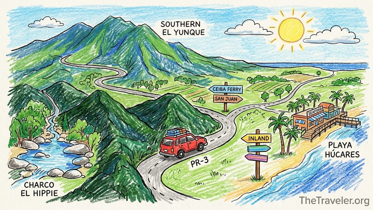
Understanding Naguabo’s Layout and Why a Car Helps
Although Naguabo is one municipality, it functions like several small destinations spread across a wide area. The pueblo (town center) with its plaza and local services sits inland along Highway PR‑31. Playa Húcares, the best-known waterfront strip with seafood restaurants and the small malecón, is several kilometers away along PR‑3 on the coast. Inland again, the Río Blanco valley and Charco El Hippie swimming area lie up winding rural roads in the foothills. Farther up, the southern access to El Yunque National Forest is another separate zone reached by different mountain routes. These areas are not easily walked between, and public transport within the municipality is sparse.
Because of that spread-out geography, having your own vehicle is usually the most practical way to explore Naguabo in a single day. You might easily drive 15 to 30 minutes between key stops, and those segments often climb or descend narrow roads where waiting around for a rare taxi is not realistic. Most Puerto Rico trip reports and local tourism planning documents recommend a rental car for any stay outside the San Juan metro area for precisely this reason. Even though rideshare services like Uber are technically available in Naguabo, pickup times are slower than in San Juan and drivers are concentrated closer to bigger towns, not on remote mountain roads.
Official tourism information typically lists central Naguabo at about one hour’s drive from Luis Muñoz Marín International Airport (SJU) in Carolina and roughly half an hour from the Ceiba ferry terminal and regional airport under normal traffic and weather conditions. These estimates assume you are driving a private car along main highways and that there are no major accidents or heavy rains. Travelers who rely only on those approximate times without considering Naguabo’s internal distances often underestimate how long it takes to combine beach time at Playa Húcares with a hike or swim in the interior in a single itinerary.
The bottom line is simple: if you plan to see more than just one waterfront area or one river pool, build your Naguabo plans around a rental car or a prearranged private driver. Walking and ad hoc taxis work only for very localized plans, such as an evening along the malecón in Húcares when you are already staying nearby.
Driving Routes to Naguabo from San Juan, Ceiba, Fajardo and Humacao
The classic approach from San Juan to Naguabo uses the island’s main eastbound toll highway before dropping to the coast. From SJU or central San Juan, most drivers take PR‑26 or PR‑18 to merge onto PR‑52 briefly, then connect to PR‑30 east toward Humacao. Near Humacao you can continue onto PR‑53, the coastal toll expressway, and exit near Naguabo to join PR‑3. Travel calculators based on typical conditions put the drive at about 75 to 80 kilometers and around 50 to 60 minutes of driving time between San Juan and Naguabo’s town center. In peak rush hour or heavy rain, it can take notably longer, so day trippers from San Juan should budget at least 1 hour each way, more if they must cross the metro area during morning or late-afternoon traffic.
From Ceiba, where the ferry to Vieques and Culebra departs and the small regional José Aponte de la Torre Airport operates, Naguabo is much closer. The drive from the Ceiba ferry terminal or airport parking lots to central Naguabo via PR‑3 and PR‑192 is commonly around 25 to 35 minutes in light traffic. Local tourism resources often round this up to “about half an hour,” which is a good planning figure if you also factor in time to exit the terminal, retrieve a car, and navigate out of Ceiba’s local streets. This proximity is what makes Naguabo a realistic stop either before or after an island-hopping trip to Vieques or Culebra.
Coming from Fajardo, another popular east-coast base, the route is similarly straightforward. You follow PR‑3 south along the coast and then continue past Ceiba toward Naguabo. Depending on where in Fajardo you start, the drive can range from about 30 to 45 minutes. This makes it feasible to stay in Fajardo for activities like boat trips to Icacos or snorkeling excursions and still drive down to Naguabo for dinner in Playa Húcares. Cost-wise, filling a compact rental’s tank for this type of back-and-forth coastal driving usually runs far less than booking multiple long-distance taxi or rideshare trips, particularly at current fuel prices that are moderate but higher than the mainland United States in many periods.
From Humacao, which sits just southwest of Naguabo, visitors typically join PR‑3 or use PR‑53 and then branch off toward Naguabo. Driving times are generally around 20 to 30 minutes depending on your starting neighborhood and whether you take the toll road or the slower coastal highway. If you are staying at a resort near Palmas del Mar in Humacao, plan on at least half an hour because of internal resort roads and occasional congestion at exits. These short distances demonstrate why Naguabo fits well into a broader east-coast itinerary that might also include Luquillo beaches, Fajardo marinas, and the Ceiba ferry.
Naguabo’s Key Areas: Coast, Rivers and Southern El Yunque
For trip planning, it helps to think of Naguabo as three separate zones rather than one consolidated sightseeing hub. The coastal area centers on Playa Húcares and nearby sections of PR‑3, where you will find the malecón, seafood restaurants, small guesthouses and views across to Vieques on a clear day. Here, walking between restaurants and photo spots is easy, but you are still a short drive from the town center and a longer drive from the interior rivers. Even if you stay in a guesthouse near Húcares, you will likely need a car or taxi to reach supermarkets and fuel stations located closer to the pueblo or along the highway.
The inland river zone runs along and above the Río Blanco valley. Well-known swimming spots like Charco El Hippie require following local secondary roads that become narrow and winding as they climb. These areas can feel very rural, with little signage and spotty cell reception in some bends. They are wonderful for travelers who enjoy charcos, waterfalls and quiet countryside views, but only if you are comfortable driving in tight curves and pulling into small parking clearings that can fill on busy weekends. Relying on a last-minute rideshare from an app at Charco El Hippie is risky; private cars with designated drivers are the norm.
The upper mountain and southern El Yunque sector begins where Naguabo’s rural roads meet the forest boundary and PR‑191’s southern segment. Historical planning documents note that the central portion of PR‑191 that once crossed the forest was damaged and has remained closed, so there is no through road from Naguabo to Río Grande across El Yunque. Instead, the southern access functions as a separate cul-de-sac into the forest from the Naguabo side. This means you must drive a loop around the mountain range if you intend to combine the popular northern El Yunque sites near Río Grande with southern viewpoints on the same day, which is rarely efficient.
These spatial separations matter in practice. A traveler might spend a late morning at Playa Húcares, then drive roughly 25 to 40 minutes inland toward Río Blanco, swim at Charco El Hippie for an hour, and then continue another short but slow climb toward El Yunque’s southern trailheads. Each leg involves packing up, driving narrow roads and parking again. Treating all of Naguabo as walkable or assuming short hops between attractions can lead to rushed visits or unsafe driving after dark.
Rental Cars, Parking and Fuel in and around Naguabo
Most visitors pick up a rental car at SJU, where all major international brands such as Enterprise, Avis, Budget, Hertz and several local companies operate. Daily rates fluctuate based on season and demand, but travelers frequently find that even when prices spike, a multi-day rental is still cheaper than chaining together long taxi journeys from San Juan to the east coast and then into rural areas. Another option is to rent from agencies in Carolina or the San Juan metro if city pick-up suits your flight times, but airport pickup is usually easier when you arrive with luggage.
Within Naguabo, on-street parking is common in the town center and near the plaza, while Playa Húcares typically offers a mix of curbside spaces and informal lots near restaurants. At peak dining times, especially on weekends or holidays, parking along the malecón can become tight, so arriving earlier in the evening or being prepared to park a couple of blocks away helps. In the Río Blanco and Charco El Hippie area, expect unpaved or partially paved pullouts and small roadside clearings used as parking. It is sensible to avoid leaving valuables visible inside the car and to park where there is clear space for other vehicles to pass on the narrow road.
Fuel availability in Naguabo itself and neighboring municipalities like Humacao and Ceiba is good along main routes such as PR‑3 and PR‑31, where you will find branded stations offering gasoline and often small convenience stores. However, there are no gas stations deep in the mountain interior near Charco El Hippie or the El Yunque boundary. Before heading inland, top up your tank near the pueblo or on PR‑3 so that you are not worrying about fuel levels while navigating steep grades. For electric vehicles, charging infrastructure outside the San Juan metro area is limited, so confirm charging options in Humacao or Fajardo before committing to an EV for an east-coast road trip.
Some travelers consider renting a car only for a segment of their trip, for example picking up a vehicle in the San Juan area the day before an east-coast excursion and returning it when they move on to Old San Juan on foot. That approach can work if agency hours and locations align with your schedule. When comparing costs, remember to include tolls on PR‑53, parking charges at SJU or city hotels, and any one-way rental fees if you are dropping the car at a different location.
Mountain Roads, Rain and Safe Driving Practices
Driving in the Naguabo interior differs significantly from cruising the coast or the island’s main toll roads. Once you leave PR‑3 or PR‑31 and begin climbing toward Río Blanco, Charco El Hippie or El Yunque’s southern entrance, expect narrow lanes, frequent curves, local traffic and occasional livestock or pedestrians on the shoulder. Speed limits are modest, and many locals know the roads well, so do not feel pressured to match their pace if you are unfamiliar with the terrain. Use pullouts to let faster vehicles pass where it is safe to do so, and avoid stopping around blind corners.
Eastern Puerto Rico receives regular rain, and El Yunque in particular generates frequent showers that can be heavier at higher elevations. In wet conditions, the pavement on mountain roads can become slick, and water may pool in depressions or run across the roadway. Driving with headlights on, reducing speed before curves and braking gently are key. After very heavy rain, small rockfalls, branches or debris in the road are more likely, especially close to the forest boundary. Night driving in the interior can be more challenging, so many visitors plan river and forest outings earlier in the day and return to the coast or their accommodation before dark.
Cell coverage can drop in certain mountain pockets, which complicates calling for assistance or using live map rerouting. Before heading inland, download offline maps for the area and save pins for key locations like your lodging, gas stations and the route to PR‑3. It is also prudent to let someone at your accommodation know your general plans if you are exploring lesser-traveled charcos or roads. Check your rental car’s spare tire, jack and basic emergency kit at pick-up; although main roads are relatively busy, waiting for roadside assistance on an interior road during rain is not ideal.
Finally, always verify the current status of specific forest roads and facilities just before visiting the southern El Yunque sector. Road closures can follow storms, landslides or maintenance, and access rules may shift seasonally. Information from a previous trip report or a guidebook can easily become outdated; the most current details will come from official forest and Puerto Rico transportation authorities. Build enough flexibility into your plans that you can substitute a coastal or river day if upper mountain access is temporarily limited.
Rideshare, Taxis and the Limits of Going Car-free
Uber is present throughout Puerto Rico, including Naguabo, and the app allows you to request rides in and out of the municipality. However, both official guidance and traveler experiences emphasize that pickup times are longer in smaller communities than in the San Juan metro area, and ride availability at off-peak hours or deep in rural zones is uncertain. In practice, this means that while you might secure an Uber from a central spot like the Naguabo pueblo or a busy area in Humacao, you cannot count on quick service at a river pullout near Charco El Hippie or a remote El Yunque access point.
Travelers who have tried to base east-coast itineraries entirely around rideshare often find that it works tolerably between major hubs like San Juan and Fajardo, where long rides can be attractive to drivers and the fare makes economic sense. Even in those corridors, securing a return ride late at night or in bad weather may require patience or a plan B. Platforms that track rideshare coverage list services in Naguabo, but that listing does not guarantee that a driver is nearby at the exact time you need them, especially for short hops that might be uneconomical for local drivers.
Traditional taxis exist in eastern Puerto Rico but tend to cluster around larger towns, marinas and ferry terminals. You are more likely to find a taxi at the Ceiba ferry terminal, near Fajardo marinas after a boat excursion, or outside certain east-coast resorts than on a side street in the Naguabo mountains. Some visitors engage private drivers or small local transport companies to cover specific transfers such as San Juan to Ceiba or San Juan to Naguabo, which can provide certainty at a pre-agreed cost. This approach is particularly common for groups or travelers who are uncomfortable driving on unfamiliar roads but still want to access smaller coastal towns.
If you are strongly committed to a car-free trip, consider structuring your Naguabo visit as a short, focused stop concentrated in one zone, such as an afternoon and evening at Playa Húcares for seafood and waterfront views. Arrange confirmed transport in and out with a reliable taxi or transfer company based in San Juan, Fajardo or Humacao, and avoid planning intermediate stops at inland charcos unless they are part of an organized tour that includes transport. For most independent travelers, though, a rental car still offers the greatest flexibility and reliability.
Sample Logistics: San Juan Day Trip, Ceiba Ferry Stop and Two-night East-coast Stay
For a San Juan based traveler considering a day trip to Naguabo, an efficient plan might start with a rental car pick-up near SJU or in Isla Verde just after breakfast. Leaving San Juan around 8:00 a.m., you drive east via PR‑30 and PR‑53, reaching Naguabo around 9:15 a.m. under normal traffic. From there, you could continue directly inland, arriving at Charco El Hippie mid-morning for a couple of hours of swimming and relaxing. Around midday, you drive back down to Playa Húcares for a late seafood lunch on the malecón, stroll the waterfront and perhaps enjoy a coffee in the pueblo before heading back to San Juan before sunset. This loop uses only main roads plus the Charco El Hippie spur, avoids most night driving in the mountains and fits comfortably into a single day if you depart early.
For travelers connecting a Ceiba ferry trip with Naguabo, think of your Naguabo stop as a decompression buffer around ferry schedules. Imagine you return from Vieques to Ceiba on a late-morning ferry. After walking off the boat and retrieving your rental car from the terminal parking, you could drive the 30 minutes to central Naguabo for lunch, resupply at a supermarket and refill your fuel tank. Later, you continue on to San Juan or Fajardo. Alternatively, on the outbound leg, you might drive from San Juan to Naguabo in the morning, explore Playa Húcares for a few hours, then continue the short drive to Ceiba in the afternoon to check in for an evening ferry. This keeps each individual drive under about 90 minutes while giving you a meaningful look at the east coast beyond the ferry terminal.
A two-night east-coast stay centered on Naguabo allows for a more relaxed pace and better weather flexibility. One practical pattern is to arrive from San Juan around midday on day one, check into a guesthouse either near the pueblo or along the coast, then spend the afternoon exploring Playa Húcares on foot and having dinner by the water. On day two, you devote the morning and early afternoon to the interior: drive up toward Río Blanco, visit Charco El Hippie, and, conditions permitting, continue farther up toward the southern El Yunque access to enjoy cooler air and mountain views. After returning to your lodging before dark, you can either cook in or drive the short distance back to the waterfront for another meal.
On day three, you might check out after breakfast and drive north toward Luquillo or west toward Humacao, stopping at other east-coast sights on the way. With two nights, you have enough time to adjust plans if the forecast calls for heavy rain on one of your days; you can shift river and mountain activities to the clearer window and keep coastal or cultural activities flexible. Throughout, the rental car allows you to pivot between zones based on weather, energy levels and any updated information about road or forest access.
Current Road Conditions, El Yunque Access and Pre-trip Checks
Conditions in El Yunque and on the mountain roads leading up from Naguabo can change quickly with storms, landslides or infrastructure work. Sections of PR‑191 and smaller access roads have historically closed for extended periods after damage, and reopening timelines are often longer than visitors expect. Furthermore, some forest access points, parking areas or recreation sites can operate under capacity limits, reservation systems or partial closures that shift from year to year or even month to month, depending on environmental and safety considerations.
Because of this variability, travelers should check road and access updates in the days immediately before their planned Naguabo mountain or El Yunque outings. That may mean looking at official transportation notices for PR‑191’s southern segment, reviewing the latest forest service updates, or speaking directly with local tourism offices or lodging hosts who monitor access for guests. Relying on older blogs, printed guidebooks or trip reports is not enough, especially if they were written before significant weather events. If you cannot confirm that a particular upper road or recreation area is open, adjust your plans to focus on confirmed accessible zones such as Playa Húcares, lower river spots or alternative coastal towns.
It is also wise to build redundancy into your navigation tools. Download offline maps that show smaller rural roads, verify which segments your rental car company allows you to drive, and keep a mental or paper note of the main route numbers connecting San Juan, Ceiba, Fajardo, Humacao and Naguabo. Before you leave a reliable service area, confirm your return route and an alternate path in case of unexpected closures or congestion. East-coast Puerto Rico is compact, but detours can still add meaningful time, particularly if a mountain route becomes unusable and traffic is redirected onto a slower coastal road.
By pairing up-to-date information with realistic expectations about driving times and conditions, you can enjoy Naguabo’s blend of sea, river and mountain without unpleasant surprises. The key is to treat logistics as part of the trip rather than as an afterthought, especially when your plans depend on a mix of highways, rural lanes and forest roads.
The Takeaway
Naguabo rewards travelers who plan their transport with as much care as their restaurant reservations and photo stops. The municipality’s best-known attractions are not clustered in a walkable grid: Playa Húcares, Río Blanco, Charco El Hippie and the southern fringes of El Yunque sit in different directions and elevations, linked by a web of highways and mountain roads rather than a single promenade. A rental car or prearranged private vehicle is therefore the most practical way to connect them, particularly if you are coming from or continuing to San Juan, Ceiba, Fajardo or Humacao.
Thinking in concrete routes and times helps. Under normal conditions, it is roughly an hour’s drive from the San Juan airport to Naguabo’s center and about half an hour from the Ceiba ferry terminal or airport. Coastal hops from Fajardo or Humacao are shorter still. Within Naguabo, however, add substantial time for slower interior roads, parking at river pullouts and weather-related caution. Rideshare apps and occasional taxis can supplement, but they are not a reliable backbone for rural exploration.
If you treat Naguabo as a set of distinct zones and accept that each will require separate drives and parking decisions, your itinerary becomes easier to shape. Use one day to combine rivers and mountains, another to linger on the waterfront, and build in buffers around ferry schedules and forest access updates. With those habits in place, Naguabo shifts from a confusing scatter of pins on a map into a coherent, enjoyable slice of Puerto Rico’s east coast.
FAQ
Q1. Is Naguabo realistically doable as a day trip from San Juan?
Yes, many travelers visit Naguabo as a day trip from San Juan by rental car. Driving times of about one hour each way under normal conditions make it feasible to combine a river stop and a coastal meal, provided you leave early and avoid rush-hour traffic where possible.
Q2. Do I really need a rental car to explore Naguabo?
You can technically reach parts of Naguabo by rideshare or taxi, but a rental car is strongly recommended if you want to visit more than one zone, such as Playa Húcares, Charco El Hippie and the southern El Yunque access. Distances, sparse public transport and limited rideshare availability in rural areas make independent driving far more practical.
Q3. How far is Naguabo from the Ceiba ferry terminal?
Central Naguabo is roughly a 25 to 35 minute drive from the Ceiba ferry terminal and the regional airport in light traffic. This proximity makes it convenient to stop in Naguabo for a meal or overnight either before sailing to Vieques or Culebra or after returning to the mainland.
Q4. Can I rely on Uber to get back from Charco El Hippie or the mountain areas?
Uber may show as available in Naguabo, but you should not rely on it for pickups at remote spots like Charco El Hippie or upper mountain roads. Drivers are few in these areas, wait times can be long or unpredictable, and cell coverage is sometimes weak, so plan to have your own car or a prearranged driver.
Q5. What are the roads like between Playa Húcares and the interior?
The main roads between the coast and the interior start as standard highways and then narrow into winding rural lanes as you climb toward Río Blanco and Charco El Hippie. Expect tight curves, changing grades and slower speeds. The route is very manageable with cautious driving, but it is not suitable for treating as a quick city-style hop.
Q6. Where can I find parking in Naguabo?
You will typically find street parking and some informal lots around Playa Húcares, curbside and plaza-adjacent spaces in the pueblo, and small unpaved pullouts near river access points. Arrive early on weekends for popular spots, avoid blocking driveways or narrow lanes and do not leave valuables visible in your vehicle.
Q7. How should I prepare for rain when driving around Naguabo?
Rain is common, especially near El Yunque. Reduce speed on wet roads, use headlights, allow extra stopping distance and watch for water running across the pavement or small debris after heavy showers. Whenever possible, schedule interior and mountain drives during daylight and be ready to change plans if forecasts call for particularly strong storms.
Q8. Is Naguabo a good base for visiting El Yunque?
Naguabo provides access to the southern side of El Yunque via rural roads and PR‑191’s southern segment, which offers a different perspective from the more visited northern entrance. It can be a good base if you want quieter surroundings, but you must check the current status of southern access roads and forest facilities just before your trip, since closures and restrictions change.
Q9. Are there gas stations and services close to the main attractions?
Gas stations and basic services cluster along main routes like PR‑3 and PR‑31 and near the Naguabo pueblo and neighboring towns such as Humacao and Ceiba. There are no fuel stations at higher elevations near Charco El Hippie or the El Yunque boundary, so fill your tank before heading into the mountains and carry water and snacks for remote outings.
Q10. How can I check for current road closures and El Yunque restrictions before I go?
The most reliable information comes from official Puerto Rico transportation and forest authorities, as well as local tourism offices and your accommodation hosts. In the week and again in the day or two before your visit, review recent official updates on PR‑191 and El Yunque access and ask locals to confirm conditions so you can adjust your Naguabo plans if needed.