
Mexico presents a complex risk environment for prospective relocators, shaped by exposure to tropical cyclones from two oceans, intensifying heat extremes, frequent earthquakes, and localized volcanic and flood hazards. Understanding how these climate and natural risks vary across regions is essential for evaluating the long-term practicality and resilience of a relocation decision.
National Climate and Natural Hazard Profile of Mexico
Mexico is one of the most hazard-exposed large economies, located at the intersection of tropical cyclone basins and active tectonic plates. Its Pacific and Gulf/Caribbean coasts experience regular hurricanes and tropical storms, while much of the interior is seismically active due to the subduction of the Cocos and Rivera plates beneath the North American plate. This combination places many urban centers and infrastructure corridors within overlapping risk zones for wind, storm surge, flooding, earthquakes, and landslides.
Recent analyses characterize Mexico as highly exposed to acute physical climate risks, with tropical cyclones and floods historically accounting for a large share of disaster losses. At the same time, climate change is amplifying heat extremes across both coastal and inland regions. Projections to mid century indicate more frequent and intense heatwaves in Mexican cities, with associated increases in heat-related mortality in the absence of strong adaptation measures.
For relocation planning, this means that risk levels differ sharply across space. Certain corridors face compound hazards, such as segments of the Pacific coast that are simultaneously high-risk for both major earthquakes and intense hurricanes. Other regions, such as parts of the central plateau, experience relatively limited cyclone exposure but elevated seismic risk and growing heat stress. A location-specific assessment is therefore critical rather than relying on a generalized impression of Mexico’s climate.
Hurricane and Tropical Storm Risk on the Pacific and Gulf Coasts
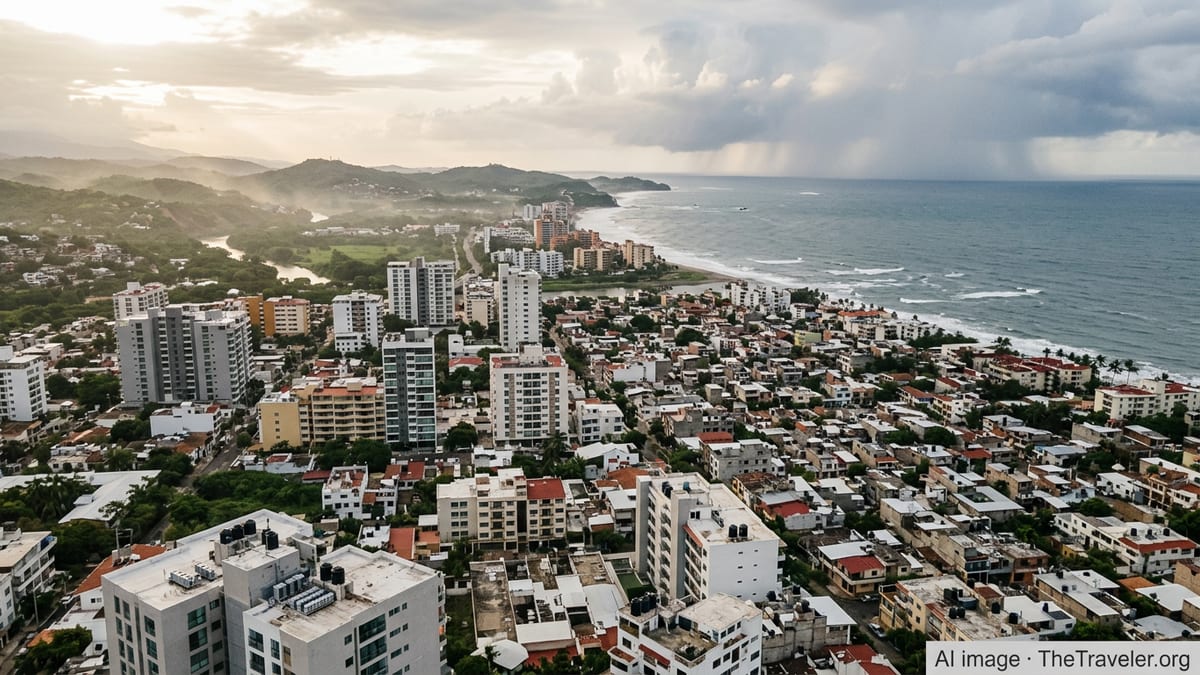
Mexico is exposed to tropical cyclones from both the eastern North Pacific and the Atlantic basin. Historical data from the second half of the twentieth century through the early twenty first century show that more tropical cyclones form and make landfall on the Pacific side, while storms on the Atlantic and Caribbean side can also be highly destructive when they track toward the Gulf coast or Yucatán Peninsula. Recent events, including major hurricanes along the Pacific coast, underscore the capacity for rapid intensification close to shore, which can reduce preparation time for coastal residents.
Along the Pacific coast, states such as Oaxaca, Guerrero, Michoacán, Colima, Jalisco, and Nayarit face recurrent landfalls from eastern Pacific storms. Studies of Mexico’s Pacific coast highlight that, on average, tropical cyclones in this region have become more intense in recent decades, with several high-end category 4 and category 5 landfalls recorded since the 1990s. This translates into elevated risk of destructive winds, extreme rainfall, and associated landslides, especially for communities on steep coastal terrain and urban areas built near rivers and unstable hillsides.
The Gulf of Mexico and Caribbean coasts, including Tamaulipas, Veracruz, Tabasco, Campeche, Yucatán, and Quintana Roo, are similarly affected by Atlantic hurricanes. While the long-term average annual landfall rate is modest relative to basin-wide storm counts, the Yucatán Peninsula is an established hotspot for hurricane-force winds. Research on the Yucatán Peninsula indicates that the annual probability of hurricane-force wind occurrence has increased when comparing the second half of the twentieth century to data through 2020, driven partly by growing exposure as coastal populations and construction have expanded.
For relocation purposes, the key considerations are the local frequency of landfalls, historical maximum wind speeds and storm surge heights, and the robustness of coastal infrastructure and building codes. Modern, purpose-built housing in hurricane-prone zones can substantially reduce life-safety risk, but service disruptions, insurance costs, and psychological tolerance for repeated cyclone seasons remain significant factors for long-term residents.
Extreme Heat, Urban Heat Islands, and Emerging Health Risks
Extreme heat has emerged as one of the most consequential climate risks in Mexico, affecting both coastal and inland regions. Recent multi-country analyses show that heatwaves in Mexico and neighboring countries are already significantly more likely due to human-induced climate change, and that associated mortality is rising as temperatures exceed historical norms. In 2023 and 2024, large parts of Mexico experienced unusually early and intense heatwaves, with maximum temperatures in some states exceeding 45 degrees Celsius during peak events.
A 2025 climate risk assessment for G20 economies notes that many Mexican cities have registered marked increases in the number of heatwave days over recent decades. Urban areas such as Monterrey, Hermosillo, Mexicali, and parts of the Mexico City metropolitan area are particularly affected by the combination of higher background temperatures, low vegetation cover, and extensive heat-absorbing surfaces. This urban heat island effect can keep nighttime temperatures elevated, reducing physiological recovery and increasing health risks for vulnerable populations.
Studies of temperature-related mortality in Latin American cities, including Mexican locations, project that heat-related deaths are likely to rise by mid century under plausible greenhouse gas emission pathways, even as cold-related mortality declines. The magnitude of this increase varies by scenario and level of adaptation, but projections consistently show that without substantial investments in cooling, green infrastructure, and health systems, the net health burden from non-optimal temperatures will grow. For relocating households, this translates into greater importance for access to reliable air conditioning, grid stability, and building designs that mitigate indoor heat.
Heat risk is not limited to desert or tropical lowlands. High-elevation cities have historically benefitted from temperate climates, but rising temperatures are narrowing this advantage. While peak daytime temperatures may remain lower than in coastal or northern desert regions, prolonged warm periods and more frequent heatwaves can still pose challenges, especially in older housing stock that was not designed for persistent high temperatures or active cooling systems.
Earthquakes, Seismic Zones, and Cascading Hazards
Mexico’s position along the Pacific Ring of Fire exposes much of the country to significant earthquake risk. The subduction of the Cocos and Rivera plates beneath the North American plate off the Pacific coast of southern and central Mexico generates frequent moderate to large earthquakes, affecting states such as Guerrero, Oaxaca, Chiapas, Michoacán, Colima, and Jalisco. Historical events exceeding magnitude 7 have caused widespread damage, landslides, and, in some cases, localized tsunamis along the coast.
Central Mexico, including the Mexico City region, is affected by seismic waves that travel inland from subduction earthquakes as well as by local faults within the Trans-Mexican Volcanic Belt. Ground conditions, including thick lakebed sediments under parts of Mexico City, can amplify shaking and prolong motion, contributing to structural damage even when the epicenter is hundreds of kilometers away. Recent decades have seen major damaging earthquakes in 1985, 2017, and 2024, with fatalities and infrastructure impacts concentrated in areas with vulnerable buildings or insufficient retrofitting.
Seismic activity also has the potential to trigger secondary hazards. Earthquake-induced landslides in mountainous terrain can lead to debris flows and road blockages, isolating communities and complicating emergency response. In volcanic regions, strong earthquakes can destabilize slopes on stratovolcanoes or their flanks, promoting debris flows that travel significant distances along river valleys. These cascading effects underscore the importance of understanding both primary and secondary seismic hazards when evaluating locations in seismically active states.
From a relocation standpoint, seismic risk requires attention to local building codes, enforcement practices, and the age and type of housing stock. Modern engineered structures built to current seismic standards perform considerably better than informal or older unretrofitted buildings. Prospective residents should also assess access to open spaces, evacuation routes, and emergency services that are designed for earthquake response.
Volcanic Activity, Flooding, and Other Localized Hazards
In addition to earthquakes, Mexico hosts several active and potentially active volcanoes, particularly along the Trans-Mexican Volcanic Belt. Notable volcanoes include Popocatépetl near Mexico City, Colima volcano between Colima and Jalisco, and El Chichón in Chiapas. Historic eruptions have produced pyroclastic flows, ash fall, and lahars that devastated areas within several kilometers of the vents. The 1982 eruption of El Chichón, for example, was the largest volcanic disaster in modern Mexican history, destroying nearby settlements and causing substantial loss of life within an approximately 8 kilometer radius.
Popocatépetl has remained persistently active over recent decades, generating regular ash emissions and occasional larger explosive events. Ash fall can disrupt air traffic, affect respiratory health, and lead to short-term closures of schools and businesses downwind, including in parts of the Mexico City metropolitan area. However, the highest life-safety risk is confined to communities closest to the volcano or along valleys that could channel lahars in a major eruption scenario.
Flooding and landslides are additional concerns in many Mexican regions. Coastal plains along the Gulf of Mexico and low-lying areas of Tabasco and Veracruz are subject to riverine and coastal flooding from heavy rainfall associated with tropical cyclones and stalled frontal systems. Mountainous states such as Oaxaca, Chiapas, Guerrero, and Puebla experience recurrent landslides triggered by intense rainfall on steep, deforested slopes. Climate projections suggest that extreme precipitation events may become more intense, which would heighten these risks where watersheds are already stressed by land-use change.
Relocating households should therefore consider volcanic hazard zones, floodplain maps, and slope stability when assessing specific properties. In many medium and large cities, high-hazard areas are known and incorporated into civil protection planning, but informal expansion and encroachment into river corridors or unstable hillsides can still create pockets of elevated risk within otherwise lower-risk municipalities.
Regional Risk Contrasts and Scenario Planning for Relocators
Climate and natural hazard risks in Mexico vary considerably by region, which allows some scope to select locations that avoid the most severe combined exposures. Broadly, the southern and southwestern Pacific coast concentrates high hurricane, seismic, and landslide risks. The Gulf and Caribbean coasts are exposed to Atlantic hurricanes and flooding, while certain northern interior regions feature extreme heat and drought but have relatively low cyclone exposure.
Conversely, some higher elevation cities in the central plateau and Bajío regions experience less direct hurricane risk and more moderate heat extremes, although they remain seismically active to varying degrees. Even within coastal states, risk can shift markedly over short distances. Locations a few kilometers inland or on higher ground may be less exposed to storm surge and coastal flooding, though still vulnerable to wind damage and heavy rainfall.
For long-term planning, it is prudent to consider how climate change may shift risk profiles by the 2040s and 2050s. Projections indicate increasing sea surface temperatures and favorable atmospheric conditions that support stronger tropical cyclones in both basins, higher sea levels that amplify storm surges, and more frequent or intense heatwaves across much of Mexico. This suggests that current hazard maps based on historical records may understate future extremes, especially for coastal and low-lying zones.
Relocators with flexibility of choice can apply a scenario-based approach: identify acceptable upper bounds of risk for hurricanes, heat, and earthquakes; then compare candidate regions and cities against those thresholds. This approach encourages explicit consideration of trade-offs such as accepting moderate seismic risk in return for lower cyclone and flood exposure, or vice versa.
The Takeaway
Mexico’s climate and natural hazard context is complex, combining dual-basin hurricane exposure, intensifying heat extremes, substantial seismic activity, and localized volcanic and flood risks. These factors do not render relocation impractical, but they necessitate a structured, location-specific risk assessment that goes beyond general impressions of the national climate.
Coastal zones on both the Pacific and Gulf/Caribbean sides offer economic opportunities and modern infrastructure but carry elevated and evolving hurricane and flood risks. Interior and highland cities reduce some of these exposures yet remain affected by earthquakes and, increasingly, extreme heat. Volcanic and landslide hazards are more spatially constrained but can be significant in specific corridors.
For decision-grade relocation planning, the priority actions are to map hazards for candidate locations, evaluate the resilience of buildings and infrastructure to those hazards, and factor future climate trends into long-term risk tolerance. By systematically weighing hurricane, heat, and natural hazard profiles, prospective residents can identify Mexican locations where risk levels align with their personal and organizational resilience requirements.
FAQ
Q1. Which parts of Mexico have the highest hurricane risk?
States along the Pacific and Gulf/Caribbean coasts face the highest hurricane risk, particularly segments of Oaxaca, Guerrero, Michoacán, Colima, Jalisco, Veracruz, Tamaulipas, and the Yucatán Peninsula, where historical landfalls and strong winds are most frequent.
Q2. Are hurricanes getting stronger in Mexico due to climate change?
Observational and modeling studies suggest that while year-to-year hurricane counts vary, the most intense storms affecting Mexico are likely to become stronger as ocean temperatures rise, increasing the potential for rapid intensification and severe wind and rainfall impacts.
Q3. How serious is extreme heat for everyday life in Mexican cities?
Extreme heat is an emerging major risk, particularly in northern and low-lying cities. More frequent and longer heatwaves can strain health, raise cooling costs, and increase reliance on reliable electricity and well-designed housing that limits indoor heat buildup.
Q4. Is central Mexico safer from climate risks than the coasts?
Central highland regions are generally less exposed to hurricanes and coastal flooding, and may have more moderate temperatures, but they remain seismically active and can still experience growing heat stress and occasional intense rainfall events.
Q5. What natural hazards are most relevant for Mexico City specifically?
Mexico City’s key hazards are earthquakes transmitted from the Pacific subduction zone and local faults, amplification of shaking by soft soils, urban flooding from heavy rain, and periodic ash fall from nearby Popocatépetl volcano, rather than direct hurricane landfalls.
Q6. Are earthquakes more dangerous than hurricanes in Mexico?
The relative danger depends on location and building quality. In some coastal states, major earthquakes and hurricanes are both significant threats, while in interior regions earthquakes dominate. Modern, well-built structures substantially reduce life-safety risk from both hazards.
Q7. How quickly are heat risks projected to increase in Mexico?
Projections to the mid twenty first century indicate that many Mexican cities are likely to see a noticeable rise in the number of very hot days and heatwaves within the next two to three decades, especially if global emissions remain high and adaptation is limited.
Q8. Are volcanic eruptions a concern for most relocators in Mexico?
Volcanic hazards are concentrated near specific volcanoes. For most urban areas, daily life is occasionally affected by ash fall rather than high-impact eruptions, but communities close to active volcanoes or lahar pathways face higher localized risk.
Q9. Can good building standards significantly reduce climate and hazard risks?
Yes. Structures designed and constructed to modern seismic, wind, and flood standards perform far better in earthquakes and storms, lowering casualty risk and reducing damage, although they cannot eliminate disruptions from prolonged heatwaves or infrastructure outages.
Q10. What is the most important step for evaluating climate risk before relocating to Mexico?
The most important step is to obtain location-specific hazard information, including hurricane, flood, earthquake, heat, and volcanic risk maps where available, and then assess how local buildings and infrastructure are designed to cope with those identified hazards.