
I pulled into the Clingmans Dome parking lot with my expectations firmly in check. I had seen the Instagram posts and the bumper-to-bumper summer traffic and assumed this “highest point in the Smokies” would feel more like a theme park than a wild mountain. A half-mile paved path to an observation tower did not sound like an adventure. But less than an hour later, standing above a rolling sea of clouds at 6,643 feet, I realized how wrong I had been.
Get the latest updates straight to your inbox!
From Skeptic to Believer on a Half-Mile Trail
The short walk to Clingmans Dome begins in a very ordinary way. You step out of your car into one of the largest parking lots in Great Smoky Mountains National Park, about a 7 mile drive off Newfound Gap Road between Gatlinburg, Tennessee, and Cherokee, North Carolina. On summer weekends, rangers help direct traffic and families spill out with strollers, selfie sticks, and steaming paper cups of coffee from Gatlinburg or Cherokee gas stations. It feels busy, not wild.
The trail itself is just 0.5 miles one way, fully paved, and at first glance looks like a leisurely stroll you might find in a city park. Then you start walking, and the grade hits. Over that half mile you gain roughly 330 feet of elevation, and the slope is unrelenting. People stop at the first bench, then the second. Kids race ahead and then sag against the stone wall, surprised at how hard their legs are working in the thin air.
On my own visit, I had mentally filed Clingmans Dome in the “touristy, do it once and move on” category. Yet as the parking lot dropped out of view, the crowds thinned, and the trail curved through a high-elevation spruce fir forest, my skepticism softened. The air was at least 10 to 15 degrees cooler than in Gatlinburg’s busy streets. Red squirrels darted through mossy logs, and the smell of evergreen resin replaced exhaust fumes. For a paved path, it felt surprisingly remote.
By the time the concrete ramp of the observation tower came into view through the mist, the mountain had already started to work on me. I still expected a good view. I did not expect the kind of view that would silence an entire crowd.
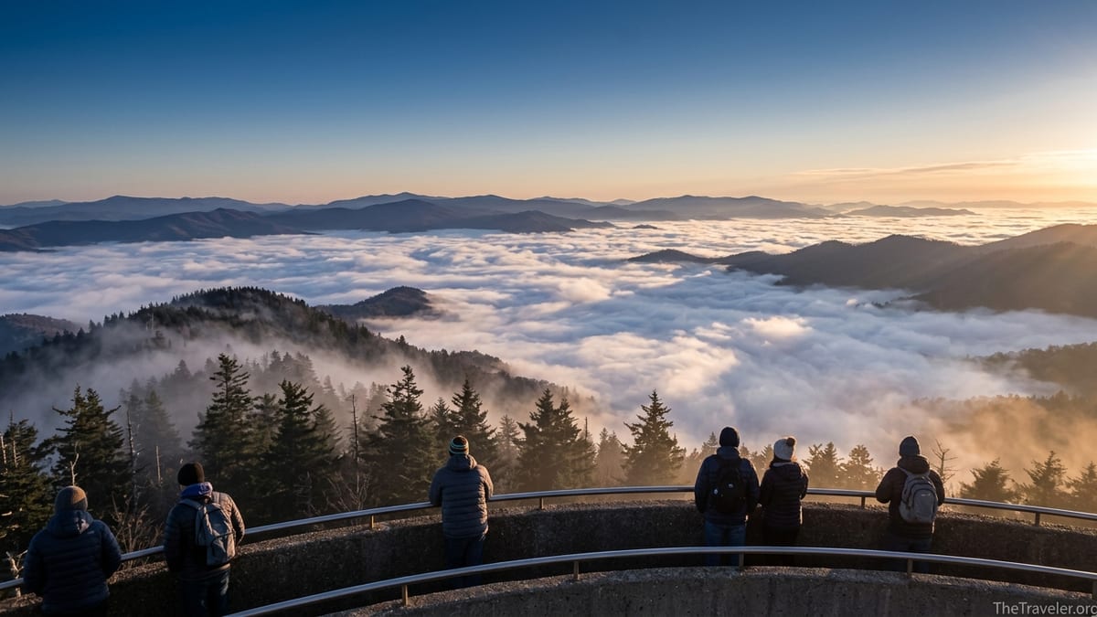
Above the Clouds at 6,643 Feet
Clingmans Dome, also known by its Cherokee name Kuwohi, is the highest point in Great Smoky Mountains National Park and in the state of Tennessee, topping out at 6,643 feet. On clear days, people talk about seeing as far as 100 miles across the layered ridges of the Smokies. But the morning I arrived, visibility from the parking lot was less than a few hundred feet. Clouds swept across the asphalt, beading water on windshields. Dozens of visitors debated whether it was worth the climb.
What most of us did not fully appreciate is that Clingmans Dome lives in its own weather world. Temperature inversions are common here. Cool, damp air often gets trapped in the valleys while slightly warmer, drier air floats above. That inversion can create the classic “sea of clouds” that photographers dream about: valleys filled with white, cottony mist while the highest ridges rise above like islands.
Halfway up the trail, the cloud thinned. The dark silhouettes of Fraser firs appeared, ghostly and still. At the top of the spiral ramp, the change was abrupt. I stepped out onto the circular platform and realized I was looking down on the weather that had seemed so discouraging from the parking lot. Clouds pooled in every hollow, hugging the lower slopes and erasing roads and buildings from view. Only blue ridgelines and sunlit peaks stood above the white.
The crowd that had gathered on the tower fell unexpectedly quiet. A ranger explained that on days like this, you are essentially standing on the top layer of the atmosphere’s morning puzzle. Below, Gatlinburg and Cherokee are still socked in with fog. Up here, at what is also the highest point on the Appalachian Trail, the sun can break through first, igniting the tops of the clouds in pale gold while the valleys remain in shadow. It feels less like a scenic overlook and more like slipping into an entirely different season.
What It Is Really Like on the Observation Tower
The Clingmans Dome observation tower itself is a simple, mid-20th-century concrete structure. A graceful spiral ramp climbs to a round platform that sits about 45 to 50 feet above the mountaintop, lifting you just high enough to clear the treeline. Design purists might find it stark, but the function is impossible to argue with: unobstructed 360 degree views across the main spine of the Smokies.
On one side, you look toward the Tennessee towns of Gatlinburg and Pigeon Forge. On another, ridges roll away toward Cherokee and the Blue Ridge Parkway in North Carolina. On clear autumn days, those ridges burn orange and red with maples and oaks. In winter, snow sometimes layers the spruce fir forest while the valleys below sit in bare brown. On a humid July afternoon, haze can soften the ridges into watercolor blues, a reminder that the park’s name comes from the smoke like mist that often hangs here.
The tower is rarely empty for long. Summer afternoons can feel like an international summit of hikers, road trippers, motorcyclists, and bus tours. You might hear conversations in half a dozen languages as people point out features on the horizon. On my visit, a family from Ohio shared trail mix with two thru hikers on the Appalachian Trail. Nearby, a local couple from Sevierville described how they schedule sunrise visits on weekdays in May or October to avoid the worst crowds.
Even when it is busy, there are quiet moments. People cluster at the ramp entrance for quick snapshots, but if you walk around the full circumference of the platform, you can usually find a gap along the concrete railing. Leaning there, facing an empty sweep of mountains and clouds, you can almost forget the tour buses entirely. The hum of conversation recedes, replaced by wind in the fir branches and the occasional call of a raven circling below.
Planning a Visit: Seasons, Timing, and Weather
One thing many first time visitors do not realize is that while the summit is open year round, the road that takes you from Newfound Gap to the parking area is not. Kuwohi Road, the park road to Clingmans Dome, typically opens around April 1 and closes by late November, with exact dates shifting slightly by year and weather. Outside those months, you can still reach Clingmans Dome, but it becomes a full day undertaking. You would need to hike roughly 7 miles each way from Newfound Gap to the summit along the Appalachian Trail, which is far beyond what most casual visitors have in mind.
Within the April to November window, timing your visit can dramatically change your experience. Midday in June or July often means full parking lots, hot pavement, and haze that limits long distance views. Early morning or late afternoon usually offers cooler temperatures, gentler light, and a higher chance of dramatic cloud formations. Many locals aim for sunrise, arriving 30 to 45 minutes before the sun peeks over the eastern ridges. In October, that can mean setting out from Gatlinburg around 6:00 a.m. to allow time for the drive and the climb.
Weather also shifts quickly with elevation. The base of the mountain near Gatlinburg may sit around 1,400 feet. By the time you reach the parking area at Clingmans Dome, you are over 6,000 feet. It is common for temperatures at the summit to run 10 to 20 degrees cooler than in town, with more wind and significantly more precipitation. A warm, humid July afternoon in Pigeon Forge can translate to a breezy, jacket worthy experience on the tower, and early fall can occasionally bring frost or a dusting of snow to the highest peaks even when lower elevations are still in shirt sleeves.
For travelers, that means packing layers even on summer days and keeping an eye on the forecast just before you go. Local cabin rental companies around Gatlinburg and Bryson City often share real time photos or webcam stills from the higher ridges on their social media feeds. While these do not guarantee conditions on the exact summit, they can help you decide whether to aim for a sunrise above the clouds or pivot to a lower elevation waterfall hike if storms are building.
Beating the Crowds Without Missing the Magic
The very things that make Clingmans Dome accessible the short paved trail, the large parking area, and the drive up a scenic spur road also make it one of the busiest spots in the park. On a sunny Saturday in July, rangers may temporarily close the road once the parking lots fill, forcing latecomers to wait until others drive out. For many visitors, the question becomes how to experience the above the clouds magic without spending the entire day in a traffic jam.
One strategy is simply to shift your schedule. If you are staying in Gatlinburg, consider grabbing an early breakfast from a local diner or coffee shop when they open, then heading straight for Newfound Gap Road before the tour buses roll. Arriving at the Clingmans Dome lot by 8:00 a.m. on a weekday in May or September often means easier parking and thinner crowds. Alternatively, plan your visit for late afternoon and stay through sunset. The road does not have a strict posted closing hour in the peak season, but park rangers typically encourage visitors to head out not long after dark. Leaving as the last light fades can mean watching the clouds shift from white to shades of pink and purple as the ridges turn to silhouettes.
Another way to find more solitude is to link your Clingmans Dome visit with a longer hike. From the parking area, the Forney Ridge Trail descends into spruce fir forest toward Andrews Bald, a high elevation meadow with its own wide open views. This out and back route can turn a quick tower visit into a half day adventure. Similarly, stronger hikers can sample the Appalachian Trail in either direction from Clingmans Dome, walking along the ridge toward Newfound Gap or toward Silers Bald. Spending even an hour on these side trails often leaves the crowds behind.
Finally, keep expectations realistic. Clingmans Dome is not a secret. Tourists have been driving here for generations, and recent social media exposure has only amplified its popularity. If you come prepared to share the experience with others, the energy can feel celebratory rather than oppressive. Families cheer when grandparents make it to the top. Kids who have never seen a true mountain range gape at the ridges. Hikers compare notes about trail conditions. That shared sense of awe is part of why the viewpoint has become such a rite of passage.
Practical Tips: What to Bring and What It Really Feels Like
Despite its short length, the climb to the observation tower catches many people off guard. The grade is steep enough that you will likely break a sweat even on cool days. Visitors who arrive directly from long drives along Interstate 40 or US 441 sometimes underestimate how the elevation will affect their breathing and pacing. This is not a technical hike, but it pays to treat it with the same respect you would give any mountain trail.
Sturdy walking shoes or light hiking shoes make the climb more comfortable, especially on the way down when the steep grade can stress knees and ankles. A light jacket or fleece is valuable even in summer, as the wind across the exposed tower can chill you quickly after the warm climb. A reusable water bottle helps, too. There are restrooms at the parking area, but there are no fountains or concessions at the summit itself, and local convenience store bottled water can feel very expensive compared to filling a bottle at your lodging before you go.
For families with young kids, lightweight strollers can technically handle the paved path, but many parents find front packs or child carriers easier given the steepness. Benches along the way create natural rest points. Older visitors or those with heart or lung conditions may want to talk with a doctor before attempting the climb and should feel zero shame about taking it slowly. Rangers and signs along the trail emphasize that the path is not considered accessible for all, despite the pavement, precisely because of the grade.
Photographers should consider bringing a wide angle lens to capture the full sweep of the ridges and clouds. A basic smartphone camera can do a surprisingly good job here, especially around sunrise and sunset, but a small travel tripod and a camera with manual settings allow you to bracket exposures when bright cloud tops contrast with dark valleys. More important than gear, though, is patience. The clouds move fast. Ten minutes can transform a completely socked in view into a window across the entire park, and then back to whiteout again.
The Takeaway
Clingmans Dome has all the ingredients that usually trigger the word “overrated” in seasoned travelers: easy access, a paved path, big parking lots, social media fame, and peak season crowds. It is easy to assume it will feel like a box to check, a postcard view that looks exactly like the one on your phone. Yet the experience on the summit rarely fits that script.
Standing above the clouds at 6,643 feet, watching dawn light spill across a sea of white while ridges rise like islands, it becomes clear why generations of visitors have made the climb. This is not just a viewpoint. It is a front row seat to the Smokies’ constantly shifting weather and light, compressed into a place that almost any reasonably fit traveler can reach in under an hour.
If you go expecting a private wilderness summit, you will be disappointed. If you go expecting a crowded roadside overlook, you will probably be surprised. Somewhere between those two images lies the reality of Clingmans Dome: a shared, democratic mountaintop experience where road trippers, thru hikers, families, and locals gather on a concrete tower to watch one of the oldest mountain ranges in the world play with the clouds.
In a park that offers hundreds of miles of quieter trails, Clingmans Dome still earns its place on the must see list. Arrive early or late, pack a jacket, bring water, and give the weather time to work its magic. You may find yourself, as I did, walking back down that steep paved path with your legs burning and your camera full, already planning when you will come back.
FAQ
Q1. How hard is the walk to Clingmans Dome?
The trail is only about 0.5 miles one way, but it gains roughly 330 feet in elevation on a steady, steep grade. Most reasonably fit visitors can do it in 15 to 30 minutes, but many people stop at benches along the way to catch their breath.
Q2. When is Clingmans Dome Road open?
The access road from Newfound Gap to the Clingmans Dome parking area usually opens around early April and closes in late November. Exact dates vary slightly each year and can change with snow, ice, or maintenance, so it is wise to confirm current conditions before you drive up.
Q3. Can I see the above the clouds view any time of year?
Above the clouds conditions depend on temperature inversions and moisture, not a specific month. They are more common on cool mornings and during seasonal transitions in spring and fall, but you can sometimes see a sea of clouds in summer or winter as well.
Q4. Is the trail suitable for strollers and wheelchairs?
The path is paved and wide enough for strollers and wheelchairs, but the steep grade makes it challenging. Many families use child carriers instead of strollers, and the National Park Service does not list the trail as fully accessible because of the sustained incline.
Q5. What should I wear to visit Clingmans Dome?
Plan for cooler, windier conditions than in nearby towns. Even in July or August, a light jacket or fleece is helpful on the summit. Wear sturdy walking shoes or light hiking shoes, and consider layers you can add at the top after working up a sweat on the climb.
Q6. Are there restrooms or food at the top?
There are basic restrooms and a small seasonal visitor contact station near the parking area, but there is no food service or water at the summit. Bring your own snacks and water, and plan to eat meals in Gatlinburg, Cherokee, or other nearby communities before or after your visit.
Q7. What is the best time of day to visit?
Sunrise and late afternoon into sunset often provide the most dramatic light and a better chance for inversions and cloud formations. These times also tend to be less crowded than midday, especially on weekdays in spring and fall.
Q8. Can I visit Clingmans Dome in winter?
You can reach the summit in winter, but the access road is usually closed from early December through March. That means you would need to hike several miles from Newfound Gap or other trailheads. Winter conditions can be harsh, so this option is best for experienced, well prepared hikers.
Q9. Is Clingmans Dome safe for kids?
Families visit Clingmans Dome every day in peak season. The main concerns are the steepness of the trail, cooler temperatures, and drop offs near some viewing areas. Keep a close eye on children near the tower railings and along the parking lot edges, and make sure everyone has appropriate clothing and water.
Q10. How does Clingmans Dome compare to other viewpoints in the Smokies?
Clingmans Dome offers the highest, broadest view in the park and the unique chance to stand above the clouds. Other viewpoints like Newfound Gap, Morton Overlook, or Andrews Bald can be less crowded and more intimate, but none combine accessibility and altitude in quite the same way.