
I thought I knew what I was getting into when I turned onto Newfound Gap Road. On the map, this spine of pavement that crosses Great Smoky Mountains National Park looked simple: roughly 31 miles between Gatlinburg, Tennessee, and Cherokee, North Carolina. An hour, maybe a little more with traffic. Instead, I found myself easing onto the shoulder or into pullouts every few minutes, unable to resist one more overlook, one more trailhead, one more layer of blue‑washed mountains rolling to the horizon.
Get the latest updates straight to your inbox!
Meeting Newfound Gap Road for the First Time
Newfound Gap Road is the main east–west corridor across Great Smoky Mountains National Park, climbing from around 1,300 feet near Gatlinburg to about 5,046 feet at Newfound Gap, the lowest drivable pass over the Smokies. It is technically U.S. Highway 441, but within the park the experience feels far removed from a conventional highway. Commercial traffic is prohibited, the speed limit drops to 35 miles per hour for most of the route, and the pavement coils like a ribbon along ridgelines and through coves.
On paper, that 31‑mile distance suggests a straightforward hour behind the wheel. In practice, very few people drive it that quickly. Between slow curves, wildlife sightings and a dense string of overlooks, picnic areas, trailheads and historic stops, it is common for travelers to spend three to five hours making the crossing, especially in peak foliage season or on a clear summer afternoon. The road is open year‑round, conditions permitting, so the exact timing of your drive will also depend on weather and any temporary construction projects.
As I left the gateway town of Gatlinburg and passed Sugarlands Visitor Center, I expected to settle into a steady climb. Instead, I spotted my first pullout less than ten minutes later: a simple gravel strip with a window onto a steep side valley stitched with hardwoods and hemlocks. It was the first of many unscheduled stops, a preview of how this road quietly insists that you slow down.
From Gatlinburg to the First Overlooks: The Road Starts to Rise
The northwestern half of Newfound Gap Road, between Gatlinburg and Newfound Gap itself, is where many travelers realize their quick drive is about to become a scenic crawl. Soon after you leave the bustle of town behind and follow the West Prong of the Little Pigeon River, the road begins to twist in earnest. Rock faces close in on one side, the river flashes silver on the other, and every few curves another pullout appears.
One early stop that tends to snag first‑time visitors is the roadside view of the Chimney Tops. From a modest paved turnout, the jagged twin peaks of this rugged summit rise abruptly above the forest canopy. Even if you have no intention of tackling the steep trail to the top, it is hard not to pause for a photo or simply to trace the ridgeline with your eyes. A few minutes later, the road slips through the dark stone of the Chimney Tops Tunnel, a momentary plunge into shadow that children in the back seat tend to celebrate with delighted shouts.
This stretch also introduces the reality of Smokies driving speeds. Even on a dry weekday afternoon, typical flow can slow to 25 miles per hour or less as drivers navigate curves, scan for wildlife and angle into popular pullouts. In peak summer, when families in rental SUVs and compact cars unfamiliar with mountain roads dominate the traffic mix, you should expect delays as drivers brake on descents and approach hairpin bends cautiously. If you budget an hour just to reach Newfound Gap from Gatlinburg, you will be far less stressed when the road ahead suddenly turns into a line of glowing brake lights.
Discovering Why Every Pullout Is Different
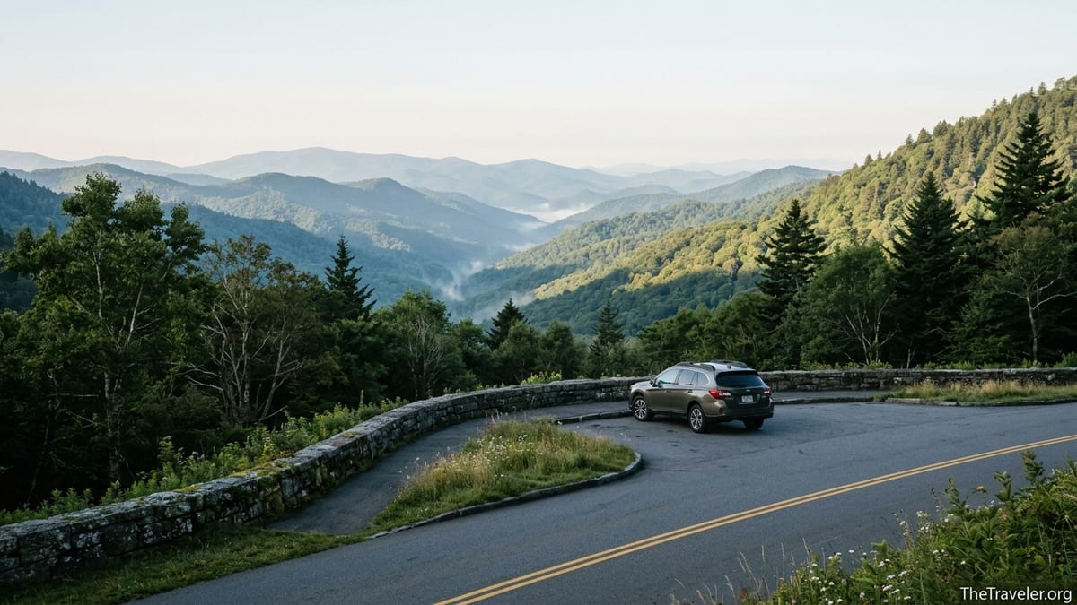
Newfound Gap Road is lined with more than a dozen formal overlooks and many additional unnamed pullouts, each with its own perspective. From the driver’s seat, the repetition might seem unnecessary. Once you step out, you realize how different the views really are. Because the road climbs and traverses multiple ridges, the angle of the valleys, the composition of tree species and the play of light change constantly.
At one unmarked pullout above the river, I watched a low cloud snag on a hemlock‑covered slope while rhododendron leaves shivered along the ditch line. A few miles farther on, at a paved overlook with stone walls, the view opened dramatically to a sequence of blue ridges fading toward North Carolina. In the late afternoon, the layers stacked one behind the other in progressively softer tones, the kind of view that tempts you to sit on the wall and simply wait for the color to shift as the sun dips lower.
For photographers, these subtle differences are reason enough to stop repeatedly. A mid‑range zoom lens in the 24–70 millimeter range captures both wide landscapes and isolated details like a single flame azalea blooming near the parking lot. Visiting in late April or early May, you might find pale green leaf‑out in the valleys while higher slopes remain gray and bare, creating a striking contrast between seasons. In October, at higher pullouts near 4,000 feet, reds and golds can peak a week or more earlier than in Gatlinburg or Cherokee below, so a short drive between overlooks can feel like time travel through the fall color calendar.
Newfound Gap: Where a View Turns into a Destination
By the time you reach Newfound Gap itself, roughly halfway along the road, pausing is no longer a temptation but a necessity. The large parking area here, often busy by midmorning in high season, serves as the hub of the entire drive. At 5,046 feet, the gap sits almost 10 to 15 degrees cooler than the valleys on many days, and a wind that barely ruffled leaves down below can feel sharp enough to send you reaching for a jacket even in June.
The main overlook looks south toward North Carolina, where on clear days you can see a layered panorama of summits and ridges extending for dozens of miles. A stone monument commemorates President Franklin D. Roosevelt’s dedication of the park, and a line painted on the pavement marks the state border. It is a classic photo stop: families straddling the line, arms thrown around each other, as another group waits patiently behind them.
Newfound Gap is also where the Appalachian Trail crosses the road. You will likely see long‑distance thru‑hikers adjusting packs near the trailhead sign, day hikers heading out for a short stroll along the ridge and people content just to walk a few hundred yards along the famous footpath before turning back. Even if your original plan was to stay in the car, stepping into the spruce‑fir forest here, with its cool, resin‑scented air, is an experience that shifts the drive from sightseeing to immersion.
Seven miles beyond Newfound Gap, a side road branches off toward Kuwohi, also widely known as Clingmans Dome, the highest point in the park at 6,643 feet. That spur road is typically open from early April through late November, weather permitting, and leads to a separate parking area and a steep paved path to an observation tower. If you add this detour, it can easily consume another one to two hours between driving, parking and walking, further transforming what looked like a quick crossing into a half‑day outing.
Dropping Toward Cherokee: Culture, Wildlife and Changing Forests
Leaving Newfound Gap and heading southeast toward Cherokee, the character of the drive shifts again. The tightest curves begin to ease, the road descends through a series of long traverses and the views open onto new valleys. Pullouts here reveal the Oconaluftee River drainage and the softer, rounded summits typical of this side of the range. After so much time climbing, the gradual downhill can feel like a relief, but the impulse to stop does not fade.
On this side of the pass, encounters with wildlife become more common. It is not unusual, especially in the evening or early morning, to round a bend and find cars pulled haphazardly onto the shoulder while passengers point phones and cameras toward a distant meadow where an elk or black bear has appeared. Rangers continually remind visitors to keep a significant distance from animals and to avoid blocking traffic, but in practice you should anticipate sudden slowdowns around any wildlife sighting. Building extra time into your schedule allows you to react safely and, when appropriate, to pull into a proper turnout for your own careful look.
As you descend toward Cherokee, the forest gradually shifts from high‑elevation spruce‑fir and northern hardwoods back to mixed oak, pine and cove hardwood communities. In spring, this side of the road can be spectacular for wildflowers. Short stops at roadside trailheads, such as those leading into damp hollows and along creeks, reward you with trillium, violets, and foamflower peeking through leaf litter. By the time you roll past the Oconaluftee Visitor Center, you have been through multiple ecological zones without ever leaving the pavement.
Just beyond the park boundary lies the town of Cherokee, with its cultural sites, small motels and roadside eateries. Many travelers plan to press straight on toward other destinations in western North Carolina. Yet after hours of stopping and starting along Newfound Gap Road, it can feel good to pause again, this time for a sit‑down meal featuring local trout or a simple burger before continuing your journey.
Planning for a Drive That Will Not Be Rushed
People are often surprised by how quickly traffic moves through the gateway towns compared with the measured pace inside the park. In Pigeon Forge and Gatlinburg, signals and multi‑lane stretches create a rhythm that feels familiar. Newfound Gap Road immediately breaks that rhythm. Between limited passing zones, 35‑mile‑per‑hour limits, and steady streams of visitors who are here to look, not to commute, you should not expect to match navigation app estimates once you enter the park.
In practice, a realistic plan for travelers who enjoy stopping is to reserve at least three hours for the crossing in good weather, more if you will add side excursions such as Kuwohi or short hikes. Starting from Gatlinburg in the late morning, you might reach Newfound Gap around lunchtime, spend time at the overlook and on the Appalachian Trail, then continue toward Cherokee with several more scenic pauses, arriving in late afternoon or early evening. If you are traveling in October, when fall colors and leaf‑peeping traffic are at their peak, it is wise to start earlier in the day to avoid the most congested hours.
Weather adds another layer of unpredictability. At over 5,000 feet, conditions at Newfound Gap can differ sharply from the valleys on the same day. A warm April afternoon in Gatlinburg might correspond to chilly fog and residual ice along shaded shoulders near the pass. In winter, snow and black ice sometimes force temporary closures of the road until crews can plow and treat the surface. Even in summer, afternoon thunderstorms can build quickly, reducing visibility and sending drivers into pullouts to wait out the rain. Checking the park’s day‑of road status via its official channels before you start can help you avoid surprises that turn a leisurely drive into a logistical challenge.
Practical Tips to Make Every Stop Count
Because Newfound Gap Road is so interruption‑prone in the best possible way, a little preparation can turn unplanned stops into meaningful experiences. Before you set out, pick up a paper map from Sugarlands or Oconaluftee visitor centers or from an information kiosk in Gatlinburg or Cherokee. This will help you recognize named overlooks and trailheads as you approach them, allowing you to decide quickly whether a stop fits your interests.
Parking is free within the park for brief stops, but if you intend to park in one location for more than 15 minutes, you are required to display a valid daily, weekly, or annual parking pass on your dashboard. These passes are modestly priced and can be purchased in the gateway towns or at visitor centers. In popular spots like Newfound Gap and the Kuwohi parking area, rangers do check for passes during busy hours, so it pays to arrive prepared rather than cut your visit short.
Food and fuel are not available along Newfound Gap Road itself. Gas up in Gatlinburg, Pigeon Forge, or Cherokee before you start the drive, and pack a simple picnic or snacks. Picnic areas such as Chimneys and Collins Creek offer tables near streams and shaded glades where you can linger without worrying about making it to the next town in time for lunch. Bring layers as well, even in summer; temperatures at Newfound Gap are frequently noticeably cooler than at lower elevations, and a light jacket or fleece can make the difference between hurrying back to the car and lingering on the overlook wall.
Finally, build flexibility into the rest of your day. If you have a hard check‑in deadline at a cabin rental in Pigeon Forge or a timed reservation in Cherokee, try not to stack it too tightly against your planned drive. Newfound Gap Road rewards those who can embrace its slower rhythm: you are far more likely to stop for an unplanned short walk down a side trail or to wait for a cloud bank to lift from the valley below if you know you do not have to be somewhere at a specific hour.
The Takeaway
Newfound Gap Road looks simple on a map: a single line crossing the crest of the Smokies. On the ground, it unfolds as a sequence of invitations to stop. A glimpse of a waterfall through the trees, a sign for a picnic area, an unmarked pullout with just enough space for three cars and a view that seems to belong on a postcard. That is why so many people who start the drive expecting to make it from Gatlinburg to Cherokee in about an hour find themselves still on the road hours later, memory cards filling with photos and schedules quietly rewritten.
If you approach this drive as a commute, you will likely end up frustrated, stuck behind slow curves and impromptu bear‑watching traffic jams. If you treat it instead as a scenic corridor meant to be savored, every extra minute becomes part of the experience. Newfound Gap Road rewards curiosity and patience. It asks you to pull over, step out, breathe the resin‑scented air and feel the temperature shift on your skin.
In the end, the allure of Newfound Gap Road lies not in how quickly it carries you across the park but in how insistently it invites you to pause. The real journey happens in those moments on stone walls and trailheads, at overlook railings and quiet creek banks, when you let the car sit cooling by the roadside and allow the Smokies to fill your senses one unhurried stop at a time.
FAQ
Q1. How long does it really take to drive Newfound Gap Road?
Most navigation apps estimate around an hour, but with traffic, photo stops and short walks, many travelers spend three to five hours on the 31‑mile crossing.
Q2. Is Newfound Gap Road open year‑round?
The road is generally open in all seasons, but winter storms and icy conditions can cause temporary closures or delays, especially near the pass at over 5,000 feet.
Q3. Do I need a permit or pass to stop along Newfound Gap Road?
You may stop briefly without a permit, but if you park for more than 15 minutes anywhere in the park, you must display a valid parking pass on your vehicle.
Q4. Are there gas stations or restaurants directly on Newfound Gap Road?
No. There are no fuel stations or restaurants along the road itself, so you should fill up and eat or pack food in Gatlinburg, Pigeon Forge or Cherokee before you start.
Q5. What is the best time of day to drive Newfound Gap Road?
Mornings typically offer lighter traffic, cooler temperatures and softer light for photography. Late afternoon can also be beautiful but may be busier, especially in fall.
Q6. Is the drive suitable for nervous mountain drivers?
Yes, but expect curves, drop‑offs and lower speeds. Staying in lower gears on descents, allowing faster vehicles to pass at pullouts and avoiding night or storm driving can ease anxiety.
Q7. Can I combine Newfound Gap Road with a visit to Kuwohi (Clingmans Dome)?
Yes. A spur road near Newfound Gap leads to Kuwohi when open, typically from spring through late fall, but adding it can extend your outing by one to two hours.
Q8. What should I pack for a day on Newfound Gap Road?
Bring water, snacks or a picnic, a light jacket, comfortable walking shoes, a paper map, a charged phone or camera and any required parking pass for longer stops.
Q9. Is cellphone service reliable along the drive?
Coverage is spotty and often nonexistent in the middle sections of the road, so do not rely on your phone for navigation or communication once inside the park.
Q10. Are there safe places to see wildlife from the road?
Yes. Use designated pullouts and parking areas to watch elk, deer or bears from a safe distance, and never stop in the road or approach animals for closer photos.