
Some roads are built to get you somewhere. The Bow Valley Parkway was built to make you stop. I set out from Banff thinking it would be a simple, scenic drive to Lake Louise along an older alignment of the Trans Canada Highway. Instead, those 48 kilometers between the townsite and Lake Louise stretched into an entire day of pulling over, wandering short trails, watching clouds snag on peaks and waiting quietly as elk and bighorn sheep decided when I could move on. Driving through Bow Valley made me stop more often than I ever planned, and that was exactly the point.
Get the latest updates straight to your inbox!
Meeting the Bow Valley Parkway on Its Own Terms
The Bow Valley Parkway, signed as Highway 1A, runs roughly parallel to the Trans Canada between the town of Banff and Lake Louise. On paper, it is only about 48 kilometers long, a gentle, mostly two-lane ribbon of pavement with a 60 km/h speed limit and regular pullouts. In reality, it feels like a living corridor where mountains, forest and wildlife all lean in close to the road. I joined the parkway after a short hop west from Banff, leaving the fast traffic of Highway 1 and almost immediately feeling the pace shift down.
What surprised me most is that you cannot just drive this road on your own schedule. Parks Canada now manages much of the eastern stretch as both critical montane wildlife habitat and, in spring and fall, a partial vehicle-free cycling route. Each year from March 1 to June 25, all travel on a 17 kilometer section between Fireside Day-use Area and Johnston Canyon is restricted between 8 p.m. and 8 a.m., and in the main spring cycling period it is closed to private vehicles during the day as well. That means if you picture yourself cruising at dawn looking for bears, you will need to adjust your plans or focus on the western part closer to Castle Junction and Lake Louise.
Before I even turned onto the parkway, I stopped at the Banff Visitor Centre to confirm current closures and restrictions, something I would strongly recommend. Staff there walked me through the seasonal rules, pointed out where the cycling-only section began for those dates, and suggested a mix of short stops that would still keep my day flexible. That five-minute conversation changed how I approached the entire drive. Instead of racing to Lake Louise, I started looking at the parkway as a full-day experience packed with potential detours.
Practically speaking, this also affected where I left my car. During the vehicle-restricted cycling periods, Parks Canada asks visitors to park in Banff, often near the train station or at designated day-use lots, and approach the eastern section by bike using the Legacy Trail. Later in the season when the full length reopens to traffic, you can join from the Trans Canada at the east junction near Banff or further west at Castle Junction. Having that mental map of junctions and timing made it much easier to accept that “getting there” was not the main goal of the day.
The Road That Makes You Pull Over
Within minutes of entering the parkway, I found my first unscheduled stop. A small brown sign for a viewpoint flashed by, followed by a gravel pullout framed by lodgepole pines. Past experience on busier highways would have told me to keep going. Here, with light traffic and good sightlines, easing off the gas felt natural. I pulled in, cut the engine and realized I could still hear the faint hum of Highway 1 across the valley, but the rest of the world was birdsong and wind.
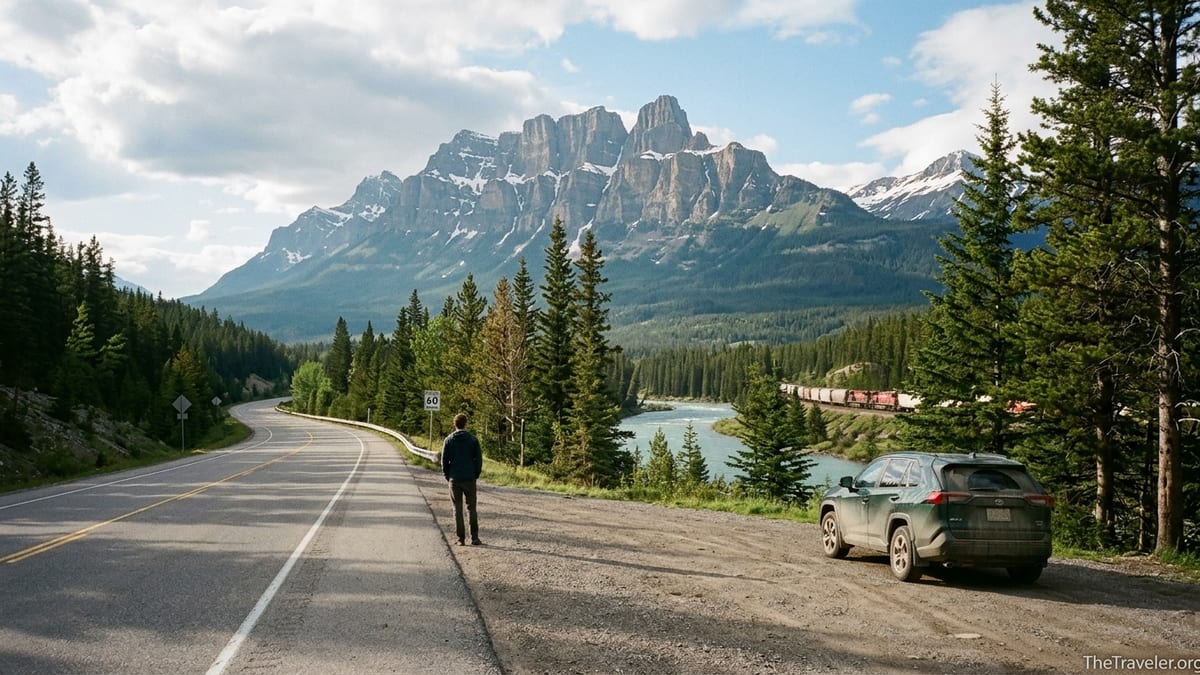
At this anonymous bend in the road, the Bow River folded back on itself in a glassy curve, with the rounded shoulders of the Sawback Range layered in soft blue behind. A freight train slid past far below, its cars tiny and toy-like. For ten minutes I simply watched, noticing how the color of the water shifted where sun reached the shallows. None of this appears in glossy brochures, yet it was exactly the kind of quiet, unbranded moment that makes the Bow Valley feel real.
These pullouts became a rhythm for the rest of the drive. Sometimes I stopped for nothing more than a stand of aspen catching late-morning light, or a view of Castle Mountain suddenly filling the windshield. Other times there were more structured viewpoints, announced by small interpretive signs that never quite prepare you for what you are about to see. The parkway’s geometry invites this behavior: long, gentle curves with frequent, safely spaced pullouts; enough space to slow down without impeding anyone behind you; and clear lines of sight to rejoin the road. It is, quite literally, engineered for pauses.
One of the biggest differences between the Bow Valley Parkway and the Trans Canada is the speed you are allowed, and expected, to travel. On the main highway, posted limits of 90 or 100 km/h keep vehicles flowing between Calgary and British Columbia. On the parkway, 60 km/h means you can spot wildlife at the roadside, read signs for trailheads like Rockbound Lake or Moose Meadows, and react in time when someone ahead eases into a pullout. The lack of large trucks and tour buses, at least compared with Highway 1, lowers the ambient stress level and makes those spontaneous decisions to stop feel less risky.
Johnston Canyon: The Detour That Becomes the Main Event
Even if you start this drive determined to avoid crowds, Johnston Canyon will test your resolve. The trailhead appears about halfway along the parkway from the Banff side, marked by a broad parking area, a lodge with cabins and a café, and a trail sign promising waterfalls in less than an hour’s walk. I arrived mid-morning on a weekday, and the lot was already stirring with hikers pulling on boots and rummaging for daypacks, an immediate reminder that even “secondary” roads in Banff National Park can feel busy in high season.
I almost kept going. Instead, I decided that any place drawing this many people probably earned a fair chance. The main trail to the Lower Falls is only about 1.1 kilometers one way, a mostly gentle walk on well-constructed catwalks bolted to the canyon wall. Within ten minutes, the noise of the parking lot had faded into the roar of Johnston Creek, carving its way through limestone in an S-shaped slot below my feet. Bridges zigzag from one side of the canyon to the other, offering constantly changing perspectives. For many visitors, especially families with kids or those not used to mountain hiking, this is one of the most accessible “big drama” experiences in the park.
At the Lower Falls, a short tunnel through the rock leads to a cramped viewpoint right beside the water. Be prepared to get sprayed and to take turns at the opening; it functions almost like a rotation system, with people stepping in for a minute and then backing out to let others have their moment. If you have the time and moderate fitness, continuing another 1.3 kilometers to the Upper Falls makes the detour even more worthwhile. The canyon broadens, pockets of forest appear between cliffs, and the catwalk gives way to regular trail before ending at viewpoints where the falls drop into a huge bowl of rock.
Johnston Canyon is a reminder that some “stops” on the Bow Valley Parkway are actually half-day commitments if you let them be. If you plan to hike here in July or August, arriving early in the morning or later in the afternoon can make parking easier and the trail feel less congested. In shoulder seasons, ice and lingering snow can turn sections into slippery puzzles, so microspikes and trekking poles are wise. Either way, setting a rough time budget for this single stop will prevent your leisurely parkway drive from turning into a race to reach Lake Louise before dark.
Castle Mountain and the Drama of the Valley Walls
Back on the road, Castle Mountain appears with almost theatrical timing. One moment the view is filtered through trees; the next, the forest parts to reveal a fortress of banded rock rising abruptly above the valley floor. The Castle Mountain Viewpoint, a simple pullout with open sightlines, has become one of the parkway’s most iconic stops for a reason. From here, the mountain’s stepped cliffs and wide summit plateau stack up like a geology textbook illustration.
Spending twenty or thirty minutes at this one spot felt entirely reasonable. Photographers hop out with tripods, but many travelers do nothing more than lean on the hood of their car and simply look. If you arrive in early or late light, the rock glows in shades of amber and rust; under midday cloud, the colors flatten, but details in the sedimentary layers become more obvious. Even without a long hike, you gain a visceral sense of how the Bow Valley slices through the Rockies, revealing cross-sections of time.
The viewpoint also makes a good place to reset your day. There is a junction here with Highway 93 South leading toward Kootenay National Park, and across the Trans Canada lies Castle Junction itself, with a small cluster of services including a gas station and simple food options. For travelers using the Bow Valley Parkway as a scenic alternative on a longer road trip from Calgary to the Okanagan or Vancouver, this is often where they rejoin the faster highway. For me, it was another prompt to linger, glance at the map and realize I still had plenty of parkway left before Lake Louise.
If you are staying in the area, Castle Mountain Chalets near this junction provide one of the most atmospheric places to overnight along the parkway. Guests step directly from cabin doors into a landscape where sunrise light hits Castle Mountain head-on. Even if you are not checking in, pausing here for a coffee or snack can help you appreciate that this road is lined not only with viewpoints, but with small outposts of human life that have adapted to the valley’s rhythm.
Morant’s Curve and the Lure of the Perfect Frame
Near the western end of the Bow Valley Parkway, not far from Lake Louise, a small signed pullout marks Morant’s Curve. At first glance, it looks like another pleasant bend in the river with spruce forest and peaks behind. Then a Canadian Pacific freight train rounds the corner, and the whole scene snaps into focus. This is one of the most photographed rail-view combinations in Canada, immortalized by railway photographer Nicholas Morant in the mid-20th century and still drawing modern travelers hoping to catch their own version of the classic shot.
The Bow River makes a graceful S-curve here, mirroring the arc of the train tracks. On the far side of the valley, mountains from the Bow Range and beyond rise in layers, including summits like Saddle Mountain and the distant ramparts of the Continental Divide. A small bank beside the pullout gives you just enough elevation to frame the scene without including too much roadside clutter. It is, objectively, a grand view even without a train present.
Waiting for that train, though, is what turns many quick photo stops into unexpectedly long pauses. Freight schedules are not posted for visitors; trains move when operational needs dictate. Some travelers report waiting 20 or 30 minutes and seeing nothing, while others luck into two trains in quick succession, one eastbound and one westbound. I spent about 40 minutes here, watching the light shift and the wind comb the valley’s patches of grass, before the distant echo of a horn announced that my patience was about to be rewarded.
If you do plan to linger, remember that this pullout, like others along the parkway, has no facilities. Bring water, respect the narrow roadside, and keep a close eye on kids. The speed limit remains 60 km/h, but vehicles still emerge suddenly from blind curves. Also be prepared for seasonal realities. In winter, plowing on the parkway can lag behind the Trans Canada after storms, and the approach to Morant’s Curve may be slick and snow-covered. In peak summer, this modest gravel strip can feel like a small photography convention, with tripods sharing space with rental cars from around the world.
Wildlife Encounters and the Art of Staying in the Car
For many visitors, the Bow Valley Parkway’s biggest appeal is the chance to see wildlife at relatively close range. Elk, bighorn sheep and deer are common; black bears and the occasional grizzly use the corridor intensively, especially in spring when new vegetation greens up quickly along the road’s sunny edges. It is precisely this richness that led Parks Canada to establish seasonal travel restrictions on the eastern section to give animals predictable periods of calm.
My own unplanned stops for wildlife began, fittingly, with a line of brake lights. A cluster of vehicles had eased onto the right shoulder near a marshy opening, hazard lights blinking. Through the windshield, I spotted a female elk standing belly-deep in new grass, her calf nearly invisible among willow stems. People stayed in their vehicles, cameras poking from open windows, creating a rare example of a “wildlife jam” handled perfectly. After a few minutes, the elk turned, led her calf into the forest, and the small convoy of cars gently rolled on.
Later, I came upon a black bear flipping over fallen logs in a meadow, searching for insects. This time, a couple of excited visitors had stepped out of their car and were standing much closer than the recommended 100 meters for bears. Within moments, another traveler pulled up and quietly called out a reminder: “You’re too close; Parks Canada can fine you for that.” The pair retreated to their vehicle, somewhat sheepishly. It was a good reminder that along this road, peer pressure and community norms often guide behavior long before wardens arrive on scene.
If you hope to see wildlife along the Bow Valley Parkway, the key is not to chase it. Drive at or below the speed limit, especially in low light. If you spot an animal, pull fully off the pavement in a designated pullout when possible, stay inside your car, keep engines low or off, and avoid feeding or calling to the animal. Remember that this valley is home first, spectacle second. The more consistently travelers treat it that way, the longer this road can function as both a world-class scenic drive and a viable habitat corridor.
Planning Around Seasons, Shuttles and Crowds
Driving the Bow Valley Parkway in 2026 is very different from doing the same trip a decade ago, largely because Banff National Park has been forced to adapt to surging visitation. The park now uses a combination of seasonal closures, shuttle systems and pricing strategies to spread people out. Understanding how these pieces fit together will help you build a day that feels relaxed instead of reactive.
On the parkway itself, the headline rule is the mandatory seasonal travel restriction from March 1 to June 25 on the eastern 17 kilometers between Johnston Canyon Campground and Fireside Day-use Area. During those months, all travel, including cycling and hiking, is prohibited on that stretch between 8 p.m. and 8 a.m. In addition, Parks Canada is extending a vehicle-free cycling pilot through at least 2030, which, in spring and fall windows, closes the same eastern section to public vehicles during daytime hours so cyclists can ride without traffic. The western part of the parkway, from Castle Junction to Lake Louise, generally remains open to regular vehicular traffic, allowing access to spots like Castle Mountain Viewpoint and Morant’s Curve even when the east side is restricted.
These rules intersect with broader crowd-management measures at nearby destinations. Lake Louise, which anchors the western end of the valley, now has extremely limited lakeshore parking during peak season, with daily parking rates that have climbed to around forty Canadian dollars per vehicle in recent years. Many visitors instead use Parks Canada shuttles that depart from the Lake Louise Ski Resort park-and-ride, a few minutes’ drive from the village services around Samson Mall. Private operators also offer pre-booked shuttle services, sometimes including sunrise runs to Moraine Lake or Lake Louise for photographers willing to start the day at 4 or 5 a.m.
For drivers combining a Bow Valley Parkway day with a visit to Lake Louise or Moraine Lake, this means making shuttle reservations well ahead of time, noting departure times and factoring in the slower travel pace of the parkway itself. Departing Banff mid-morning, meandering along the parkway with multiple stops, hiking Johnston Canyon and still expecting to catch a mid-afternoon shuttle at the ski hill is possible but tight. Far better is to give the parkway a dedicated day, or to drive it in the opposite direction on your way back from a mountain lake morning.
The Takeaway
By the time I reached the junction where the Bow Valley Parkway meets the road up to Lake Louise, the day had stretched and softened around the dozens of small decisions to stop. I had not seen every viewpoint or walked every short trail. I had missed some wildlife and likely arrived moments too late for at least one perfect train shot at Morant’s Curve. Yet I felt more deeply connected to Banff National Park than I had on previous trips when I sped along the Trans Canada counting down kilometers to famous lakes.
Driving through Bow Valley made me stop more often than I ever planned because the road, the management policies and the landscape all conspire to slow you down. Seasonal travel restrictions and cycling pilots force you to think about when and how you move. Short, accessible hikes like Johnston Canyon turn “quick looks” into half-day engagements. Viewpoints beneath Castle Mountain or above anonymous river bends reward quiet attention rather than checklist efficiency.
If you come here expecting a fast, scenic commute between Banff and Lake Louise, this road will frustrate you. If you accept that it is less a shortcut and more a long, unfolding conversation with the valley, it will likely become one of your strongest memories of the Canadian Rockies. The Bow Valley Parkway is not about covering ground; it is about letting a remarkable stretch of ground cover you, briefly, in its own rhythm.
FAQ
Q1. Is the entire Bow Valley Parkway open to cars year-round?
The western section between Castle Junction and Lake Louise is usually open year-round, but the eastern section near Banff faces seasonal night closures and, in spring and fall, daytime vehicle restrictions for a cycling pilot. Always check current Parks Canada updates before you drive.
Q2. How long does it take to drive the Bow Valley Parkway without stopping?
Without traffic or stops, you can technically cover the 48 kilometers between Banff and Lake Louise in about 45 minutes to an hour, but most travelers take several hours or even a full day once you add viewpoints, wildlife pauses and a hike at Johnston Canyon.
Q3. Do I need a reservation or permit to drive the Bow Valley Parkway?
You do not need a separate reservation for the parkway itself, but you must have a valid Parks Canada park entry pass for Banff National Park. During vehicle-restricted cycling periods, you may need to park elsewhere and access the eastern section by bike instead of by car.
Q4. When is the best time of day to see wildlife along the parkway?
Wildlife is often more active in the early morning and late evening, but seasonal night travel bans on parts of the road mean you should plan within legal hours. Drive slowly, stay alert and never approach or feed animals.
Q5. Can I visit Johnston Canyon and still drive the full parkway in one day?
Yes, many visitors hike to the Lower or Upper Falls at Johnston Canyon and then continue along the parkway the same day. Plan at least half a day, and more in peak summer, to avoid feeling rushed between trail time and scenic stops.
Q6. Is the Bow Valley Parkway suitable for winter driving?
The parkway is maintained in winter, but snow and ice can linger on shaded curves and plowing often happens after the main Trans Canada. Winter tires are strongly recommended from November through March, and you should check for temporary closures after storms.
Q7. How does the Bow Valley Parkway connect with Lake Louise shuttles?
The parkway brings you toward the Lake Louise junction, but most official shuttles to Lake Louise and Moraine Lake depart from the Lake Louise Ski Resort park-and-ride off the main highway. You may want to combine a shuttle-based lake visit with a separate, slower parkway day.
Q8. Are there gas stations or food stops directly on the parkway?
Services are limited. You will find fuel and basic food at Castle Junction near the midpoint, but there are no large service plazas. It is wise to fill up your tank in Banff or Lake Louise and carry snacks and water for the day.
Q9. Can I cycle the Bow Valley Parkway instead of driving?
Yes, cycling is increasingly popular here, especially during the spring and fall vehicle-restriction periods when part of the road is reserved for bikes. The route has gentle grades but is still a substantial ride, so plan your fitness, weather and daylight carefully.
Q10. Do I need to worry about parking availability at viewpoints and Johnston Canyon?
Small roadside viewpoints usually have space turning over regularly, but Johnston Canyon can fill early in peak season mornings. Arriving before mid-morning, visiting later in the afternoon, or traveling outside July and August helps reduce parking stress.