
If you are driving through New Jersey, you will almost certainly face a classic local question: Parkway or Turnpike? Both the Garden State Parkway and the New Jersey Turnpike are major toll roads that roughly parallel each other north to south, yet they feel very different on the ground. The better choice depends less on loyalty or habit and more on your route, timing, vehicle, and travel priorities. Here is a practical guide, grounded in real examples, to help you decide which road actually makes more sense for your next trip.
Get the latest updates straight to your inbox!
Understanding the Basics: Two Very Different Highways
The New Jersey Turnpike and the Garden State Parkway are both operated by the New Jersey Turnpike Authority, but they were built for different purposes and serve different kinds of trips. The Turnpike runs from the George Washington Bridge approach area in northern New Jersey down to the Delaware Memorial Bridge in the southwest, acting as a long-distance interstate corridor that carries heavy truck and through traffic between New York, Philadelphia, and points south. Tolls are distance based, calculated by where you enter and where you exit.
The Garden State Parkway, by contrast, runs roughly 173 miles from Exit 0 in Cape May at the southern tip of the state to the New York State line in Bergen County. It was designed as a landscaped parkway connecting North Jersey suburbs to the Jersey Shore and coastal communities. Instead of distance-based tickets, it uses an open system of flat-fee toll plazas spaced along the route, with most car tolls a few dollars or less per plaza depending on current schedules.
In practical terms, that means the Turnpike is often the better choice if you are hauling straight through New Jersey between major metro areas, such as traveling from Baltimore to New York City. The Parkway tends to be better if you are accessing specific New Jersey destinations, especially shore towns like Point Pleasant, Long Beach Island, or Cape May, or if you prefer a somewhat greener, more local-feeling drive.
For example, a driver going from Newark Liberty International Airport to Center City Philadelphia will almost always choose the Turnpike to reach the Delaware River bridges efficiently. A family leaving suburban Montclair for a week in Ocean City will usually head for the Parkway, dropping south past exits for coastal towns instead of angling over to the Turnpike.
Route Planning: When the Parkway Makes More Sense
The Garden State Parkway comes into its own when your trip is focused on New Jersey destinations rather than simply passing through. It shadows the state’s eastern side and offers direct or near-direct access to many shore points and suburban communities that would be awkward to reach from the Turnpike.
Consider a summer Friday trip from northern New Jersey to Long Beach Island. On the Parkway, you drive south to around mile marker 63 and follow the Route 72 connection toward Manahawkin and the island. Travelers making this run every summer often stay entirely on the Parkway from places like Clifton or Paramus and simply follow the familiar pattern of toll plazas and exits until they see signage for LBI. Taking the Turnpike instead would require cutting across on local highways such as Interstate 195 or Route 70, which can add time and complexity.
The same holds true for popular boardwalk towns. Ocean City, Sea Isle City, Avalon, Wildwood, and Cape May all sit closer to the Parkway, with signed connections from exits in Cape May and Atlantic counties. A family driving from Morristown to Wildwood might use the Parkway virtually the entire way, leaving only for the final approach on local roads. Using the Turnpike for this itinerary would mean dropping well inland and then working back east through a patchwork of state routes.
North of the shore region, the Parkway is also the more intuitive choice for many commuters who live in Monmouth or Ocean counties and work in North Jersey. For instance, someone commuting from Toms River to an office in Woodbridge might stay on the Parkway the entire way, taking advantage of its express and local lane configurations north of the Raritan River and intersecting routes that feed into corporate parks and suburban job centers.
Route Planning: When the Turnpike Is the Smarter Option
There are many scenarios where the New Jersey Turnpike is clearly the better choice. Its design favors longer-distance, higher speed travel with wide lanes and long acceleration ramps, especially in the mainline car and truck lanes between about Exit 4 and Exit 14. If your origin and destination are both outside New Jersey, or you are mostly trying to connect major cities, the Turnpike is often faster and more straightforward.
For example, a driver going from Washington, D.C. to Manhattan will typically take Interstate 95 into the New Jersey Turnpike near the Delaware Memorial Bridge and stay on it to the complex of exits around Newark and the George Washington Bridge approach. While it is technically possible to cut over to the Parkway near Woodbridge, doing so usually adds lane changes, merges, and potential slowdowns that do not benefit a through trip.
Similarly, truckers and those driving large commercial vehicles are often required or strongly encouraged to use the Turnpike, since commercial traffic is restricted on parts of the Parkway, particularly north of Exit 105 in Monmouth County. A small moving truck on a local rental might be allowed in some sections, but full tractor trailers and heavier rigs are expected to stay on the Turnpike’s designated truck lanes, where they have room to maneuver and access to truck services.
Even for personal travel, the Turnpike can be a better bet when you are aiming for New Jersey’s industrial and port districts, or for direct connections to major airports. Someone heading from suburban Cherry Hill to Newark Liberty International Airport, for instance, will generally enter the Turnpike in South Jersey, stay in the mainline lanes, and follow the clearly signed spur to the airport complex, avoiding the extra weaving that would come with switching to the Parkway near the Raritan River.
Tolls, Costs, and E-ZPass: Which Road Is Cheaper?
Cost is another key factor when choosing between the Parkway and the Turnpike. The New Jersey Turnpike uses distance-based tolling. You take a ticket or record your entry point electronically, then pay when you exit, with total cost tied to how many miles you traveled along the Turnpike. For a long north-south trip across most of the state, the toll for a passenger car can reach into the mid-teens of dollars, with discounts offered at certain times for New Jersey issued E-ZPass accounts according to current schedules.
The Garden State Parkway operates differently. It uses mainline toll plazas and ramp tolls where passenger vehicles pay flat fees, typically a couple of dollars at each barrier based on the latest official rates. If you are making a short hop between two nearby exits and cross only one toll plaza, your total outlay might be just a few dollars, regardless of how much of the rest of the Parkway you did not use. Over a very long trip involving several plazas, however, the cumulative cost can approach or exceed what you might have paid for a similar-distance run on the Turnpike.
To see how this works in practice, imagine driving from Exit 150 in Bloomfield to Exit 63 for Long Beach Island. You would encounter multiple toll barriers in Essex, Union, and Ocean counties. Each one would charge a flat rate based on the class of your vehicle, with slight discounts if you use E-ZPass or travel in designated off-peak periods. A similar length trip on the Turnpike, such as from Exit 15W near Newark to Exit 4 near Mount Laurel, would result in a single distance-based toll that might be comparable in total but structured differently on your statement.
Travelers planning multiple trips or frequent commutes often use the official toll calculator provided by the New Jersey Turnpike Authority to compare approximate costs. In many cases, if you are moving from one end of New Jersey to the other without many intermediate exits, the Turnpike can be slightly more predictable in cost. If you are doing a shorter run that happens to cross only one Parkway toll, the Parkway may be marginally cheaper. Because toll schedules can change, especially around January of a given year, it is wise to check the latest rates before assuming one is always more affordable than the other.
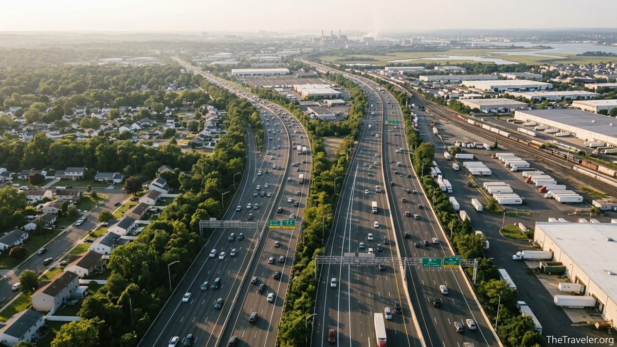
Traffic, Speed, and Driving Experience
Both highways see heavy traffic, but the experience of driving them is different enough that it can affect your choice. The Garden State Parkway was built to run through more scenic areas, with long stretches of trees, wetlands, and glimpses of coastal inlets, especially between Toms River and Cape May. For many local drivers, the Parkway feels more pleasant and “New Jersey like,” especially compared with the Turnpike’s industrial vistas through Newark, Elizabeth, and the refineries along the Arthur Kill.
That said, the Parkway can become intensely congested around traditional bottlenecks, particularly near the Union toll plaza area, the interchange with Interstate 78, and the Raritan River crossings on summer weekends. A Saturday morning drive from North Jersey to the shore can slow to a crawl between Exits 135 and 117, with backups as drivers funnel toward beach-bound exits. In those conditions, some travelers choose to switch to NJ Transit rail lines or shift their departure to very early morning or late evening to avoid the worst slowdowns.
The Turnpike also has its chronic pinch points, especially around Exits 13 to 15E near the Newark Bay extension and the approach to the George Washington Bridge. However, because the highway was engineered as a high-volume interstate corridor, with express and local carriageways in its northern sections and generous shoulders, many drivers find it easier to maintain highway speeds when traffic is moving. A midweek, midmorning run from Exit 8A to Exit 14 can feel almost effortless compared with threading the same corridor on local or Parkway routes.
Your personal comfort level matters here. If you are uneasy with heavy truck traffic and prefer to avoid driving beside tractor trailers, you might find the Parkway less stressful, particularly in its car-only stretches. If you are more concerned with maintaining a steady 65 or 70 miles per hour on a long-distance run and you are comfortable around commercial vehicles, the Turnpike’s wider lanes and longer sightlines can be a relief.
Access, Exits, and Services Along the Way
Another big difference between the two roads is how they connect to the rest of New Jersey. The Parkway has many more exits than the Turnpike, especially through the suburban counties of Bergen, Passaic, Essex, Union, Middlesex, Monmouth, and Ocean. It ties into local arteries leading to towns like Montvale, Bloomfield, Clark, Holmdel, and Toms River. This makes it convenient for reaching shopping centers, office parks, and residential neighborhoods but also means more weaving traffic near exit ramps.
The Turnpike, by contrast, has fewer, more widely spaced interchanges, each typically feeding into a regional highway or major arterial road. Exits like 4, 7, 7A, 8A, and 13 serve broad areas such as Mount Laurel, Trenton, the Route 130 corridor, and the ports of Newark and Elizabeth rather than a single town. For a traveler passing through, that simplicity is an advantage: fewer decisions, fewer merges, and clearer numbering for long-distance navigation.
Services are robust on both roads but differ a bit in character. The Turnpike features a well known chain of full service service areas named after notable New Jersey figures, with fuel, restrooms, and fast food options that cater heavily to truckers and interstate travelers. Places like the Molly Pitcher or Joyce Kilmer service areas are designed so you can pull in, refuel both car and driver, and get back on the highway without dealing with local streets.
The Parkway also has a series of service plazas, including well known stops like the Cheesequake service area in Middlesex County, which can be accessed by traffic in both directions via internal ramps. These plazas tend to focus more on passenger vehicles and vacation traffic, especially in the sections that serve beach-bound drivers. In summer, you are likely to see minivans loaded with coolers and beach chairs at these stops, alongside day trippers grabbing coffee before the last push to Cape May or Seaside Heights.
Vehicle Type, Restrictions, and Safety Considerations
Your vehicle type can determine which highway you are allowed or advised to use. The New Jersey Turnpike is built to handle everything from compact cars to full tractor trailers. Separate car and truck lanes exist in some northern segments to manage heavy freight volumes safely. Service areas offer diesel fuel pumps, truck parking, and other amenities needed for long-haul drivers.
The Garden State Parkway, in contrast, has more complex rules for commercial and larger vehicles, particularly in its northern reaches. Certain types of trucks are prohibited on segments of the Parkway, especially north of Exit 105, where the road crosses older bridges, passes through tighter suburban corridors, and was not engineered with full-size tractor trailers in mind. Rental box trucks under specific weight limits may be allowed in some portions, but drivers of anything larger should consult current New Jersey Turnpike Authority guidelines or ask the rental agency for route advice.
From a safety standpoint, both roads are heavily patrolled by state troopers and are subject to strict speed enforcement. The Turnpike’s design generally supports steady, high-speed travel with multiple lanes and modern barriers, which can reduce conflict points but may encourage tailgating and lane weaving during busy periods. The Parkway’s tighter curves, shorter entrance ramps in older sections, and high density of exits can create more stress for less experienced drivers, particularly at night or in poor weather.
If you are driving a personal car and are unfamiliar with the region, it can be worth planning your interchange points in advance. For instance, the massive junction where the Parkway meets the Turnpike near Woodbridge combines tight curves, multiple decision points, and high traffic volumes. Entering it unprepared can be intimidating. Taking a moment before departure to study the sequence of lanes you need, or using a navigation app with clear lane guidance, can make either road feel far more manageable.
The Takeaway
There is no single right answer to whether the Garden State Parkway is “better” than the New Jersey Turnpike. Each road was built with a different mission in mind, and the better choice depends on where you are starting, where you are going, what you are driving, and how you like to travel. If your journey is essentially a straight shot between the mid Atlantic and New York metro areas, and you value efficient, high speed travel with minimal decision points, the Turnpike will usually serve you well.
If, on the other hand, your trip is all about New Jersey itself, especially the suburbs and shore towns that define the state for many residents, the Parkway is likely the road that best matches your route. Its numerous exits make it ideal for reaching destinations like Long Beach Island, Asbury Park, or Cape May, and its more landscaped feel offers a reminder of why it earned the “Garden State” name in the first place.
For many travelers, the most realistic approach is flexible rather than loyal. You might enter New Jersey on the Turnpike for its direct connection to bridges and airports, then switch to the Parkway at Woodbridge to access Monmouth County beaches, or do the reverse on the return trip depending on time of day and traffic conditions. With a bit of planning, both roads can be useful tools rather than sources of frustration.
Before you set out, consider your specific itinerary. Plot your likely toll costs on each road, check recent traffic patterns around known bottlenecks, and think about how comfortable you are with heavy trucks or tight merges. With that information in hand, choosing between the Garden State Parkway and the New Jersey Turnpike becomes less of a guessing game and more of a simple, strategic decision.
FAQ
Q1. Is the Garden State Parkway or the New Jersey Turnpike usually faster?
The faster route depends on your origin, destination, and time of day. For long through trips between Delaware and New York, the Turnpike is often faster. For shore-bound travel from North or Central Jersey, the Parkway can be more direct but may clog on summer weekends.
Q2. Which road is cheaper in tolls for a typical family trip?
Costs vary by distance and how many toll plazas you cross. A long Turnpike trip charges a single distance based toll. A long Parkway trip may involve several flat fee plazas. For shorter hops across one Parkway plaza, the Parkway often costs a bit less. For end to end travel, differences can be modest.
Q3. Which highway is better for reaching Jersey Shore towns?
The Garden State Parkway is generally better. Exits in Ocean, Atlantic, and Cape May counties are designed to feed towns like Long Beach Island, Ocean City, Wildwood, and Cape May. The Turnpike lies farther inland and requires more crossover on local highways.
Q4. Can trucks use the Garden State Parkway?
Some smaller commercial vehicles are allowed in certain sections, but full size trucks face significant restrictions, especially north of Exit 105. Tractor trailers are expected to use the New Jersey Turnpike, which is built and signed for heavy truck traffic.
Q5. Which road offers better services and rest areas?
Both have full service plazas with fuel and food. The Turnpike’s service areas are geared toward long distance and truck travel. The Parkway’s plazas tend to see more vacationers and local drivers, especially near shore exits, but amenities like restrooms and fuel are available on both.
Q6. Is one route more scenic than the other?
Most travelers find the Garden State Parkway more scenic, particularly between Toms River and Cape May where it passes through pine forests and coastal wetlands. The Turnpike is more industrial in its northern sections, with views of ports, refineries, and rail yards.
Q7. How does traffic compare on summer weekends?
On sunny summer weekends, the Parkway can become heavily congested southbound in the morning and northbound in the evening as shore traffic surges. The Turnpike can also be busy, but its patterns are more tied to general regional travel and less to beachbound waves.
Q8. Which highway should I use to reach Newark Liberty International Airport?
For most travelers coming from South or Central Jersey or from out of state via Interstate 95, the New Jersey Turnpike is the better choice because it has a direct spur and clear signage to Newark Liberty International. The Parkway connects to the region but usually requires extra interchanges and local connectors.
Q9. Do I need E-ZPass to use either road?
No, you can still pay cash at staffed toll booths where available, though some plazas are converting more lanes to electronic collection. E-ZPass generally speeds up tolling and can offer modest discounts on both the Turnpike and Parkway, especially for frequent travelers.
Q10. How should I decide between the Parkway and the Turnpike for a specific trip?
Start with your exact start and end points, then map both options. Consider which road gives more direct access, compare toll estimates using the official calculator, and look at live traffic conditions near key bottlenecks. Also factor in your comfort level with trucks, exits, and merges. Often the best choice will be clear once you see how each road lines up with your route.