
The high desert plateau of southeastern Utah hides a maze of sandstone canyons where silence, starlight, and ancient dwellings still define the landscape. Two names come up over and over for serious hikers and backpackers: Grand Gulch itself and the broader Cedar Mesa region that surrounds it inside Bears Ears National Monument. Both deliver remote wilderness, fragile archaeological sites, and serious logistics. Yet they feel very different on the ground. If you are wondering whether to plunge straight into Grand Gulch or roam the wider web of Cedar Mesa canyons, this guide will help you decide which Utah backcountry adventure fits you better.
Get the latest updates straight to your inbox!
Understanding the Landscape: Grand Gulch Inside Greater Cedar Mesa
To understand the choice, it helps to know that Grand Gulch is not separate from Cedar Mesa. Grand Gulch is a long, serpentine drainage that cuts through the western edge of Cedar Mesa, a pinyon-juniper plateau rising above Comb Wash and the San Juan River in southeastern Utah. The Bureau of Land Management manages Grand Gulch as part of the Cedar Mesa Special Recreation Management Area and as a Wilderness Study Area, which means rugged trails, minimal facilities, and a deliberate emphasis on solitude and resource protection.
Cedar Mesa itself is much larger than Grand Gulch. It includes a broad network of canyons and side drainages like Bullet Canyon, Sheiks Canyon, Todie Canyon, Owl and Fish canyons, and the Citadel area out toward Road Canyon. Many of these canyons connect into Grand Gulch, while others form their own separate loops and overnights. When people talk about “going to Cedar Mesa,” they might be planning a day hike to a single ruin, a multi-day traverse in Grand Gulch, or a backpacking loop that only briefly touches the main gulch.
In practical terms, Grand Gulch is the main backcountry “artery,” with classic routes such as Kane Gulch to Bullet Canyon or Kane Gulch to Collins Canyon. Cedar Mesa is the whole circulatory system of trailheads, side canyons, and mesa-top drives off Utah Highways 95 and 261. Deciding between “Grand Gulch” and “Cedar Mesa” is really about how focused or wide-ranging you want your trip to be, and how comfortable you are with navigation, water hunting, and route-finding in rarely patrolled terrain.
Most visitors will pass the same front door either way: the Kane Gulch Ranger Station on Utah Highway 261, about four miles south of its junction with Highway 95. This low brick building at the top of the Kane Gulch trailhead is the permit hub and information center for both Grand Gulch and much of Cedar Mesa, staffed seasonally in spring and fall.
Permits, Logistics, and Accessibility
Permits are a non-negotiable part of this decision. The BLM requires day-use passes for hiking in many Cedar Mesa and Comb Ridge canyons inside Bears Ears National Monument, and separate overnight backcountry permits for backpacking routes like Grand Gulch. You can typically obtain day-use permits at self-serve fee tubes at popular trailheads and at Kane Gulch Ranger Station. Overnight permits for Grand Gulch and surrounding canyons are more tightly controlled and are usually picked up in person at Kane Gulch or arranged in advance by phone when the permit desk is operating.
For a concrete example, a typical visitor driving in from Monticello or Blanding will stop at Kane Gulch when it opens in the morning, watch the required short video on visiting archaeological sites respectfully, confirm current water reports, and pick up an overnight permit for a three-day Kane Gulch to Bullet Canyon traverse. Meanwhile, a casual hiker staying in Bluff might simply grab a day-use pass at the trailhead for a half-day exploration of a short Cedar Mesa canyon like Mule Canyon to see a well-known ruin before returning to town for dinner.
Access also differs between Grand Gulch-focused itineraries and wider Cedar Mesa explorations. The Kane Gulch trailhead has a paved parking lot and restrooms right off Highway 261, making it one of the easiest entry points into the backcountry. In contrast, many Cedar Mesa trailheads branch off onto graded or occasionally rough dirt roads that may be deeply rutted after late-spring thunderstorms or slick after fall rains. High-clearance vehicles are often recommended for roads leading to trailheads like Bullet Canyon, Sheiks Canyon, or Owl and Fish canyons. In late March or early April, a rental SUV with decent tires is a practical choice if you plan to reach more remote trailheads.
Season also affects how “accessible” each experience feels. Kane Gulch Ranger Station is typically staffed in spring and fall, often from roughly March through June and again from September through October, with reduced or no ranger presence in the heat of summer and depths of winter. If you are new to the region and want face-to-face planning help, anchoring your trip around Grand Gulch in prime season can reduce uncertainty. More self-reliant hikers with desert experience may be comfortable visiting other Cedar Mesa canyons even when services are minimal, as long as they research water sources and current regulations ahead of time.
Experience Profile: Who Grand Gulch Fits Best
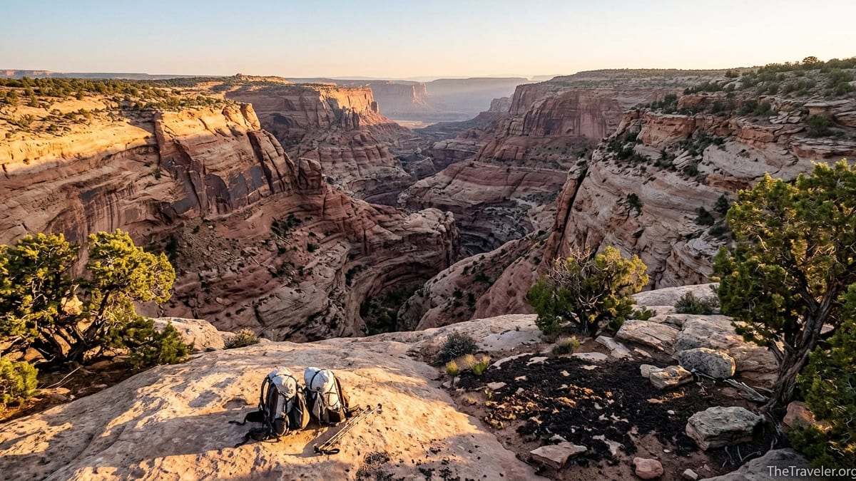
Grand Gulch is best suited for hikers and backpackers who want a canyon-centered, immersive backcountry experience with a clear narrative route. Think of a party of three experienced backpackers flying into Salt Lake City, driving south, and dedicating four days to a point-to-point trip from the Kane Gulch trailhead down to Bullet Canyon, arranging a vehicle shuttle or paid shuttle service beforehand. Their priority is to live in the canyon for several days, move camp each night, and see a dense concentration of cliff dwellings and rock art while following a relatively well-known but still rugged route.
Once you descend from the rim via Kane Gulch, the world shrinks to a twisting canyon floor, shaded alcoves, tamarisk thickets, stands of cottonwood, and intermittent streambeds. The trail is often more of a use path braided across sand and bedrock, and it may require frequent crossings of the watercourse after spring storms. Hikers can pass well-known sites like Junction Ruin and Turkey Pen Ruin on routes that many strong intermediate backpackers can manage if they are comfortable with uneven footing and a full pack. Daily mileage might be in the 6 to 10 mile range, with camps in sandy clearings beneath towering walls.
Because Grand Gulch is a signature destination, you are more likely to see other small parties in peak weeks such as late April or mid-October compared with some lesser-known Cedar Mesa side canyons. It will not feel like a national park front-country trail, but you may exchange route tips with another group at a water source or pass a guided archaeological hiking group, especially near popular ruins. That can be a positive for those who want remote hiking but feel reassured by the occasional human presence.
If you value a continuous canyon story, want built-in access to ranger information at the start of your trip, and feel drawn to backpacking itineraries that link classic named sites day after day, Grand Gulch is usually the better fit. It also makes sense for your first serious Bears Ears backpack, especially if you budget in a day before or after to stroll a short rim hike or explore a roadside overlook like Muley Point on the mesa top.
Experience Profile: Who the Wider Cedar Mesa Backcountry Fits Best
The broader Cedar Mesa backcountry is ideal for travelers who prefer to build their own mosaic of hikes rather than commit to one long canyon. This might be a couple driving a high-clearance rental truck who set up a dispersed car camp on nearby public land outside the most restricted zones, then tackle a different day hike or single-night backpack each day for a week. One day they might hike down Owl Canyon to see an alcove ruin, the next they might walk mesa-top slickrock out toward The Citadel, and later in the trip they might complete the classic Fish and Owl loop if they have the skills and permits.
Cedar Mesa shines for hikers who enjoy navigating primitive routes, reading topographic maps, and are comfortable turning back if a pour-off or dryfall exceeds their skill level. Many canyons have only intermittent cairns or social trails. Instead of following a single main gulch with a defined reputation, you are moving between options, each with its own personality: a short scramble to a balcony ruin here, a sunbaked slickrock bench there, or a narrow pour-off that might hold a shallow pothole of precious water after a storm.
Another group drawn to wider Cedar Mesa is the traveler who wants to mix culture and comfort. For example, a family might stay in a lodge or vacation rental in Bluff or Blanding, driving out each morning for a moderate day hike such as exploring a signed trail in Butler Wash or an easier out-and-back canyon that passes a few accessible ruins without committing to multi-day packs. They may stop at an Indigenous-run cultural center or local museum on the way back into town, grounding the archaeological sites they saw in a living context rather than viewing them as abandoned relics.
If your style is to improvise based on weather and how you feel each morning, and you enjoy driving remote dirt roads as much as walking in the canyons themselves, the greater Cedar Mesa network may fit you better than committing to the main Grand Gulch corridor from start to finish.
Water, Difficulty, and Safety: How Grand Gulch and Cedar Mesa Compare
Water is a defining factor in both Grand Gulch and Cedar Mesa and should heavily influence where you go and when. In many springs, Grand Gulch itself holds more reliable seeps and pools than some smaller side canyons. Backpackers often plan camps near known water sources, checking with the Kane Gulch rangers within a day or two of their trip to get current reports. In a good year, you might find flowing water in stretches between Kane Gulch and Bullet Canyon in April, while by late May some of those flows may have retreated to isolated, sometimes murky pools that require careful treatment.
In wider Cedar Mesa, water can be more hit or miss. Certain canyons or springs, such as pockets of Shieks Canyon or shaded bend pools in Fish and Owl, are often mentioned by experienced hikers as relative “water magnets,” but they still fluctuate with snowpack and recent storms. If you choose to explore non-Grand Gulch canyons, you should be prepared to cache water at trailheads, carry heavier loads on some days, or plan your routes to intersect known water sources in mid-canyon, always with a backup plan if they are drier than expected.
In terms of technical difficulty, most of Grand Gulch is non-technical hiking and backpacking, though steep, loose entries and occasional boulder obstacles are standard. Strong, fit hikers comfortable with off-pavement travel but not interested in ropes or exposed downclimbs will often find Grand Gulch right in their sweet spot. In contrast, some Cedar Mesa canyons outside the main gulch require route-finding around minor dryfalls, brushy bypasses, or short scrambles that can feel committing to newer hikers, especially when carrying overnight packs.
Safety in either area hinges on preparation: detailed maps or a GPS track downloaded in advance, knowledge of flash flood risks during monsoon season (usually late July into September), a realistic understanding of your daily mileage in deep sand and on rocky terrain, and conservative decision-making around archaeological sites. Search and rescue is many miles away, cell coverage can be absent or patchy, and even a simple ankle injury can become serious. As a rule of thumb, if you are less experienced or traveling with children, early trips focusing on Grand Gulch’s better-known segments or shorter Cedar Mesa day hikes are wiser than plunging straight into a remote, unmarked loop.
Cultural Sites and Ethics: Seeing More by Touching Less
Both Grand Gulch and the surrounding Cedar Mesa backcountry are among the most significant cultural landscapes in the United States, with thousands of Ancestral Puebloan sites scattered across alcoves, ledges, and cliff faces. In practice, Grand Gulch condenses many famous dwellings and rock art panels into a narrower corridor, which is one reason it draws more overnight backpackers. You might pass three or four major ruin clusters in a single day between Kane Gulch and Bullet Canyon, along with countless smaller granaries and petroglyphs that may be unmarked but still protected.
In the wider Cedar Mesa network, you may hike an entire day to reach one or two marquee sites such as a balanced-rock fortress ruin out a spur ridge or a remote citadel perched at the end of a narrow neck of slickrock. The trade-off is that you often experience longer stretches of pure landscape and solitude between visits to cultural sites. Many seasoned hikers who return year after year to Cedar Mesa prefer this slower rhythm, accepting that a single well-earned ruin can feel more meaningful than a rapid-fire sequence of sites.
The ethical obligations are the same in both areas. Visitors are expected to stay on established paths where they exist, avoid stepping inside structures or on ancient walls, leave all pottery sherds and artifacts where they lie, and maintain a respectful distance from rock art. In practical terms, that means photographing a metate still carved into bedrock from a distance with a zoom lens rather than leaning on it, or explaining to children why picking up a small, beautiful sherd for “just a closer look” erases part of the site’s story for everyone else.
Because both Grand Gulch and Cedar Mesa sit inside Bears Ears National Monument, visitors are also asked to think beyond “ruins as objects” and recognize that these are living cultural landscapes for Native communities today. Choosing a slightly less popular route, spreading out your campsites, and moderating social media posts that give away fragile locations are all small, real-world ways to reduce pressure on specific sites, whether you are walking Grand Gulch’s main corridor or a quieter side canyon on Cedar Mesa.
Sample Itineraries: Matching Trips to Travelers
It can be easier to decide between Grand Gulch and the broader Cedar Mesa backcountry by picturing actual trips. Imagine two friends from Denver with long-weekend flexibility in April. They drive in on a Thursday, overnight in Monticello, and show up at Kane Gulch Ranger Station as it opens on Friday. They secure an overnight permit and hike down Kane Gulch for a three-day, two-night out-and-back to Junction Ruin, camping in the canyon bottom both nights and returning to the trailhead Sunday afternoon. That is a Grand Gulch-focused trip: one entry point, one canyon, and a deep dive rather than a wide sampler.
Now picture a pair of road-trippers in a campervan with a week to wander the Four Corners region in October. They spend two nights at a commercial campground outside Bluff with hookups, taking mellow day hikes to a signed roadside ruin in Butler Wash and a short section of a Cedar Mesa canyon. Then they move onto the mesa itself, drive a graded dirt road to a trailhead like Owl Canyon, shoulder packs for a single-night backpack, and loop back to the van. After that, they might continue west toward Natural Bridges National Monument or north toward Moab. This is classic wider Cedar Mesa use: multiple short forays, mixing lodging types and canyon styles, without committing the entire trip to Grand Gulch.
Experienced desert backpackers often stitch the two together. One example itinerary for a strong group in May might start with a three- or four-day Grand Gulch traverse from Kane Gulch to Bullet Canyon or Collins Canyon, followed by a rest day in Blanding with a hot shower and restaurant meal, then two or three days of day hiking in lesser-visited Cedar Mesa canyons or on rim routes overlooking Comb Wash. This blended approach lets you savor the iconic Grand Gulch experience while still tasting Cedar Mesa’s variety.
Finally, consider your non-hiking companions. If you are traveling with someone who loves landscapes but not heavy packs, centering your route around the wider Cedar Mesa region gives you more flexibility. They can relax at a viewpoint such as Muley Point, explore a museum in town, or drive scenic Highway 95 while you take a shorter solo day hike, then regroup for sunset at an easily accessible overlook. Grand Gulch, by contrast, is harder to sample unless everyone in your party is ready to commit to at least a long day hike in and out of the canyon.
The Takeaway
If you crave a linear, immersive canyon journey and want to maximize the number of archaeological sites you encounter in a relatively compact area, Grand Gulch is likely your best match. It offers a clear sense of progression from rim to river country, practical support through the Kane Gulch Ranger Station during core seasons, and established backpacking routes with a reputation that matches their reality. For many hikers, a first multi-day trip in Grand Gulch becomes the anchor memory that keeps them returning to Bears Ears.
If instead you are drawn to improvisation, to connecting scattered canyons, mesa-top vistas, and occasional overnights into a more open-ended week or two on the plateau, then think in terms of Cedar Mesa rather than just Grand Gulch. Approached thoughtfully, the greater Cedar Mesa backcountry lets you shape each day to your energy level and the weather, from short family-friendly walks to committing loops like Fish and Owl. It rewards curiosity, patient route-finding, and a willingness to accept that some routes or ruins will remain just out of reach.
Whichever option you choose, the essentials are the same: obtain the proper permits, build in time to talk with rangers or permit staff if they are available, carry more water capacity than you think you need, and treat every archaeological site as if a descendant family might visit it tomorrow. Done well, both Grand Gulch and the wider Cedar Mesa backcountry offer something increasingly rare: days where your primary concerns are weather, water, and the simple privilege of walking quietly through a living desert.
FAQ
Q1. Do I need a permit for both Grand Gulch and other Cedar Mesa canyons?
Yes. Day-use passes are required for many canyons on Cedar Mesa, including Grand Gulch, and separate overnight backcountry permits are needed for backpacking routes. These are typically obtained at trailhead fee stations and the Kane Gulch Ranger Station, or reserved in advance when the permit office is operating.
Q2. Which is better for first-time desert backpackers, Grand Gulch or wider Cedar Mesa?
Most first-time desert backpackers find Grand Gulch a better starting point because routes like Kane Gulch to Junction Ruin follow a well-established canyon corridor with more reliable information on water and conditions. Wider Cedar Mesa demands more route-finding and planning, so it is usually better tackled after you have some local experience.
Q3. When is the best time of year to visit Grand Gulch or Cedar Mesa?
Spring and fall are generally best, roughly March through early June and September through October, when temperatures are cooler and the Kane Gulch Ranger Station is more likely to be staffed. Summer heat can be extreme and winter storms can make access roads icy or muddy, so plan outside peak heat and deep winter if possible.
Q4. Do I need a high-clearance or four-wheel-drive vehicle?
You can reach the Kane Gulch trailhead for Grand Gulch on paved Highway 261 with a standard vehicle in normal conditions. However, many other Cedar Mesa trailheads sit at the end of dirt roads that can become rutted or slick, so a high-clearance vehicle is strongly recommended if you plan to explore multiple side canyons beyond the main Grand Gulch entry.
Q5. How difficult is navigation in Grand Gulch compared to other Cedar Mesa canyons?
Navigation in Grand Gulch usually follows a single canyon bottom with occasional use paths and obvious landmarks, though maps or GPS are still important. In other Cedar Mesa canyons, routes may be less defined, with more cross-country sections and decision points, so navigation often requires more experience reading terrain and topographic maps.
Q6. Is water easier to find in Grand Gulch or in other Cedar Mesa canyons?
In many seasons, Grand Gulch tends to have more reliable water in seeps and pools than some smaller side canyons, especially in spring. Elsewhere on Cedar Mesa, water availability varies widely and may require careful planning, heavier carries, and up-to-date information from rangers or recent trip reports.
Q7. Can I visit ruins without doing a multi-day backpack?
Yes. Both Grand Gulch and the wider Cedar Mesa region offer day hikes to accessible archaeological sites. You might do a long day hike partway down Kane Gulch and back, or choose shorter Cedar Mesa routes that reach ruins within a few miles of the trailhead, making it possible to see significant sites without carrying an overnight pack.
Q8. How crowded should I expect Grand Gulch and Cedar Mesa to be?
Grand Gulch typically sees more backpacking traffic, especially on popular routes in April and October, but still feels remote compared with national parks. Other Cedar Mesa canyons can be much quieter, with some routes seeing only a few parties even in prime season. Holidays and good-weather weekends are busier everywhere, so shoulder dates offer more solitude.
Q9. Are guided trips available, and are they useful for this area?
Several regional outfitters offer guided backpacking and hiking in and around Bears Ears, including Grand Gulch and selected Cedar Mesa canyons. Guided trips can be very helpful for first-time visitors who want expert navigation, water planning, and cultural context, or for those who prefer not to manage shuttle logistics and permits on their own.
Q10. How can I minimize my impact on archaeological sites and the desert environment?
Stay on durable surfaces, camp on previously impacted areas where allowed, pack out all trash and toilet paper, and never enter or touch dwelling walls or remove artifacts. Use a zoom lens rather than approaching rock art, keep group sizes modest, and avoid sharing precise locations of fragile sites online. These simple steps help protect both Grand Gulch and the broader Cedar Mesa landscape for future visitors and descendant communities.