


Grand Gulch is not the kind of canyon you stumble into by accident. Tucked into the Cedar Mesa plateau within Bears Ears National Monument in southeastern Utah, it sits hours from the nearest major airport, at the end of lonely two-lane highways and dirt roads that turn to mud with one desert storm. Yet for hikers willing to plan ahead and carry their world on their backs, this unassuming drainage reveals one of the most remarkable hidden landscapes in the American Southwest: a sinuous sandstone canyon sheltering hundreds of Ancestral Puebloan sites, seasonal springs, soaring walls and a silence that is increasingly hard to find.
Get the latest updates straight to your inbox!
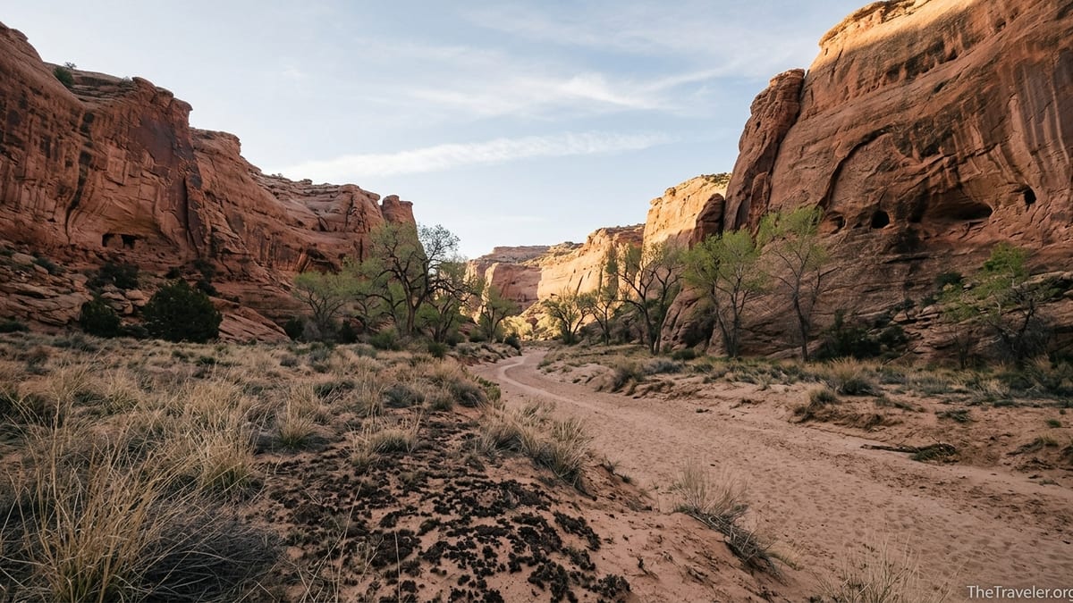
A Canyon Carved in Secret at the Heart of Cedar Mesa
On a map, Grand Gulch looks like a crooked branch etched into the southern edge of Cedar Mesa, draining south toward the San Juan River. On the ground, it unfolds as a continuous corridor of sculpted sandstone, alcoves and side canyons that can swallow a hiker for days at a time. Unlike the famously wide vistas of the Grand Canyon or Zion, Grand Gulch feels intimate. The canyon walls rise a few hundred feet, close enough that you can study every streak of desert varnish and every ledge where a granary clings to the rock.
Most travelers first meet the canyon at one of three main trailheads: Kane Gulch, Bullet Canyon or Collins Canyon. From Kane Gulch Ranger Station on Utah Highway 261, a well-used trail drops gradually into a shallow wash before the walls steepen and the canyon begins to twist. Hikers who continue roughly 4 miles from the ranger station may reach Junction Ruin, where Kane Gulch meets Grand Gulch proper and the first cluster of cliff dwellings announces that this is far more than a scenic hike.
Further west, the Bullet Canyon trailhead offers a steeper, more rugged entry point. Here the route scrambles down slickrock benches into a deeper gorge, passing under pour-offs and around house-sized boulders. Still farther along the mesa edge, the Collins Canyon trailhead drops into a tributary that eventually meets Grand Gulch near the lower reaches of the system, within a day’s hiking of the San Juan River. Each access point gives a different perspective, but all share a sense that you have stepped off the modern map into a self-contained world.
Part of what makes Grand Gulch remarkable is that it remains largely undeveloped. There are no paved walkways, interpretive signs or railings inside the canyon. Once you leave the trailhead, the only infrastructure you are likely to see is the faint line of a boot path, a few cairns at confusing bends and the occasional old cowboy inscription fading on a cliff. It feels like a place the 21st century somehow forgot, and many visitors regard that as its greatest luxury.
An Open-Air Museum of Ancestral Puebloan History
The real distinction of Grand Gulch lies in its extraordinary density of Ancestral Puebloan sites. Archaeologists estimate that people farmed and foraged in these canyons for over a thousand years, from roughly 200 to 1300 CE, leaving behind a patchwork of cliff dwellings, granaries, kivas, petroglyphs and pictographs tucked into almost every suitable alcove. On a typical two or three day backpacking trip, it is common to pass dozens of structures, many hiding just far enough off the main wash that only careful observation reveals them.
One of the best-known sites, Junction Ruin, rests on a bench above the confluence of Kane Gulch and Grand Gulch. Here hikers can look across to standing masonry walls, small rooms and storage structures built from sandstone blocks and mud mortar. A short distance downstream, another alcove shelters Turkey Pen Ruin, named for the low stone enclosure where domesticated turkeys were once kept. Both sites offer a vivid sense of daily life, from the soot on the ceilings to the tiny doorways that preserved precious warmth in winter.
Farther into the canyon, travelers who commit to multi-day trips encounter panels of rock art such as the Quail Panel, reachable on a long trek via either Collins Canyon or Kane Gulch. The panel’s stylized birds and human figures speak across centuries in ochre and white pigment. Even when visitors do not know the stories behind the images, the sheer age and craftsmanship create a powerful sense of continuity with the present-day Diné, Hopi and Pueblo peoples who trace cultural connections to these landscapes.
What sets Grand Gulch apart from more heavily visited archaeological parks is how unsupervised the experience feels. Unlike Mesa Verde, where access to cliff dwellings is tightly guided, or Bandelier, where ladders and railings manage the flow of visitors, Grand Gulch’s sites are generally viewed from a respectful distance, with only the occasional BLM sign reminding hikers not to enter rooms, touch walls or disturb artifacts. This combination of freedom and responsibility can be deeply moving, but it also demands a high level of care from every person who walks the canyon.
A Wilderness Experience Few Canyons Can Match
Grand Gulch is managed by the Bureau of Land Management as part of the Cedar Mesa canyons, and it has more in common with designated wilderness than with highway-side viewpoints. There are no campgrounds inside the canyon, only dispersed campsites on sand benches and slickrock terraces above the wash. Water comes from seeps and springs that can shift with the seasons, so backpackers plan routes around known sources such as Todie Canyon, Step Canyon or Polly’s Canyon and often call the Kane Gulch Ranger Station a few days before arrival to ask about current conditions.
Because there are no pit toilets, trash cans or picnic tables, everything a group brings in must be carried back out, including used toilet paper and, for overnight trips, human waste in pack-out systems where required. On a practical level this means a Grand Gulch trip feels more like a wilderness river expedition, with a strong emphasis on self-sufficiency. A typical three day, two night loop from Kane Gulch might see a party carrying 2 to 3 liters of water per person between springs, bear-resistant food storage, a stove for cooking on slickrock and sturdy footwear for long hours on uneven stone.
The payoff for this effort is solitude that is increasingly rare in the desert Southwest. Permits limit the number of people entering each trailhead per day, so even at popular times it is possible to hike for an hour without seeing another group. In shoulder seasons it is common to camp on a sand bench beneath cottonwoods and hear nothing but night wind in the trees and the sound of an owl echoing off the canyon walls. For many visitors who have battled crowds in Arches or Zion earlier in the same trip, that quiet feels like a revelation.
The physical hiking is engaging without being technical. Most routes involve walking in dry sandy washes, weaving around boulders and occasionally negotiating small pour-offs or ledges. During spring snowmelt or after heavy rain, pools in the canyon floor can require short wades. Trekking poles help stabilize tired legs on long days, and a 40 to 60 liter backpack is sufficient for most two or three night outings. Compared with steeper canyon systems in the Escalante or the technical slots of Buckskin Gulch, Grand Gulch welcomes strong hikers who may be newer to backpacking, provided they are prepared for remoteness.
Permits, Fees and the Practicalities of Getting In
Unlike many hidden corners of the Southwest, Grand Gulch is not free to wander into at will. The Cedar Mesa canyons use a permit system to protect fragile sites and limit crowding. Day use passes are required year round for Grand Gulch and its tributaries, and overnight permits are mandatory for backpacking. For most visitors, this starts with checking in at the Kane Gulch Ranger Station, which functions as the local permit office and an information hub with maps, displays and a small bookstore.
Day hikers typically obtain permits at self-serve kiosks at major trailheads like Kane Gulch, Bullet Canyon and Collins Canyon. The fee is generally per person for each day in the canyon rather than per vehicle, and many travelers budget roughly the cost of a casual restaurant meal per person for a day’s access. Overnight backpacking permits are more tightly controlled, with daily quotas for each trailhead, especially in peak seasons like late March through May and late September into October when temperatures are milder.
Practical planning usually involves reserving overnight permits in advance through the BLM’s Cedar Mesa system, then picking up the physical permit and a wag bag kit at the ranger station before driving to the trailhead. Since the station operates on seasonal hours that can change from year to year, many visitors build in flexibility, arriving the afternoon before their start date in case they need to adjust their itinerary based on updated water reports or weather forecasts. Phone service on Cedar Mesa is spotty at best, so it is wise to confirm hours and any special rules weeks ahead of time when trip planning from home.
Travel logistics add another layer of Grand Gulch’s hidden character. The canyon lies several hours’ drive from Moab, Monument Valley or Durango. Visitors often base themselves in the small towns of Blanding or Bluff the night before a trip, stocking up on groceries, white gas canisters or extra water jugs at local markets and gear shops. From there, the drive up Utah Highway 95 and across Highway 261 onto Cedar Mesa offers its own sense of transition, passing viewpoints like Comb Ridge and the Moki Dugway, where pavement gives way to steep switchbacks on graded dirt high above the Valley of the Gods.
Respecting a Living Cultural Landscape
For all its wildness, Grand Gulch is not an empty place. It is part of a living cultural landscape for Native communities including Navajo, Hopi and Pueblo peoples who maintain ties to Cedar Mesa and Bears Ears. Many of the structures and rock art panels that hikers admire are more than archaeological curiosities. They are expressions of ongoing cultural and spiritual traditions, which makes respectful behavior not just a matter of following regulations but of honoring living descendants.
In practice, responsible travel in Grand Gulch means maintaining a respectful distance from dwellings and granaries, never entering rooms or climbing onto walls, and resisting the temptation to rearrange artifacts. Pottery sherds, corn cobs and stone tools must be left exactly where they lie, even if they seem out of place. Experienced guides often coach first-time visitors to practice “hands in pockets” behavior near sites to avoid absentminded contact with fragile masonry or painted surfaces.
Modern impacts are visible when people fail in this responsibility. At some sites in Grand Gulch and neighboring canyons, ancient walls bear graffiti carved by cowboys in the late 19th and early 20th centuries. More recent damage includes footprints on kiva roofs, rubbed rock art and missing artifacts. These scars are part of why the permit system exists and why rangers stress low-impact practices in every pre-trip briefing and printed brochure.
Cultural respect also extends to photography and social media. Many regulars in the region choose not to geotag specific sites when sharing images of alcoves or panels, preferring to describe locations only in general terms such as “Grand Gulch, Bears Ears” rather than revealing exact side canyons. For travelers, adopting similar habits helps keep more delicate sites out of the path of sudden viral popularity that has overloaded other once-quiet destinations across the West.
When to Go and What a Trip Really Feels Like
Seasonality shapes Grand Gulch perhaps more than any other factor. Spring and fall are the prime windows, when daytime highs on Cedar Mesa often sit in the comfortable 60s to 70s Fahrenheit and nighttime temperatures dip into the 30s or 40s. In April, cottonwoods along the canyon floor leaf out in soft green against red sandstone, and pools may be fuller from winter snowmelt. In October, golden leaves frame ruins and rock art, and the lower angle of the sun paints long shadows across alcoves.
Summer brings a very different character. Daytime temperatures on the mesa can climb past 90 degrees, and the exposed approach hikes into the canyons feel punishing under direct sun. Thunderstorm season, typically July into early September, adds the hazard of flash floods in narrow sections of the canyon. While experienced desert hikers sometimes still venture in early or late summer, most visitors avoid midseason or limit themselves to short day hikes with very early start times and careful eye on weather forecasts.
Winter visits are possible in lighter snow years but require significant flexibility. Storms can render the access roads icy or muddy, the Moki Dugway can feel intimidating in bad conditions, and short daylight hours compress hiking time. Overnight temperatures can plunge well below freezing on the mesa, and seeps that backpackers rely on may slow to a trickle or ice over. As a result, many winter visitors opt for day hikes from Kane Gulch with plans to turn back earlier than they might in shoulder season.
On the ground, a multi-day trip into Grand Gulch feels like a blend of desert backpacking and time travel. A typical second day might start at first light with coffee brewed on a small canister stove while the canyon walls glow pink overhead. Hikers shoulder 25 to 35 pound packs, follow the braided wash downstream and soon catch sight of a faint alcove high on the left wall. A closer look reveals blocky rooms and the faded shapes of handprints. After a quiet half hour of observation from a respectful distance, the group moves on, dropping past a sequence of boulder gardens, lunching in the shade of cottonwoods near a trickling spring and finally choosing an elevated sand bench for camp, where stars spill down canyon at night.
The Takeaway
Grand Gulch has none of the instant iconography of the Grand Canyon or Monument Valley. There are no roadside overlooks, no famous stone arches framed in a single, definitive photograph. Its power lies instead in accumulation: the patient curve of the canyon, the steady rhythm of walking and the quiet discovery of one stone room after another. For travelers who value depth over spectacle, that combination makes it one of the most remarkable hidden canyons in the American Southwest.
In a region where many landscapes now strain under heavy visitation, Grand Gulch offers a model of a different kind of tourism: small numbers of prepared visitors moving lightly through a fragile place, taking only photographs and leaving even the smallest artifact in place for those who come next. The required permits, long drives and desert logistics filter out casual crowds but reward anyone willing to do the work of planning with a sense of connection that is hard to come by in more accessible parks.
For some, the canyon becomes a once-in-a-lifetime journey. For others, it plants a seed that draws them back in different seasons and from different trailheads, piecing together the system as a whole. Whether you spend a single day walking to Junction Ruin from Kane Gulch or commit to a multi-day traverse from Bullet Canyon to Collins, it is difficult to leave Grand Gulch without a sharpened sense of how landscapes hold memory and how carefully we must tread in places where the past is still written in every wall.
FAQ
Q1. Where exactly is Grand Gulch located? Grand Gulch lies on Cedar Mesa in southeastern Utah, within Bears Ears National Monument, roughly between the towns of Blanding and Mexican Hat.
Q2. Do I need a permit to hike or backpack in Grand Gulch? Yes. Day use permits are required for all visits, and overnight backpacking permits are mandatory for any multi-day trip in Grand Gulch and its tributary canyons.
Q3. What is the best time of year to visit Grand Gulch? Spring and fall offer the most comfortable conditions, with moderate temperatures and more reliable water sources. Late March through May and late September through October are particularly popular.
Q4. How difficult are the hikes in Grand Gulch? Most routes are non-technical but involve long days on uneven terrain, sand and slickrock, with some scrambling and occasional wading. They are best suited to reasonably fit hikers with some backpacking experience.
Q5. Are there guided trips available, or is it all self-guided? The canyon is primarily a self-guided destination, but a handful of permitted outfitters and guides based in nearby communities offer small group trips that handle logistics and route planning.
Q6. Can I camp anywhere in Grand Gulch? Dispersed camping is allowed on durable surfaces such as sand benches and slickrock away from archaeological sites and water sources. Campfires are typically prohibited, so visitors should plan to use stoves for cooking.
Q7. Are pets allowed in the canyon? No. Pets are not allowed in Grand Gulch or many neighboring Cedar Mesa canyons in order to protect wildlife, fragile soils and cultural sites.
Q8. How should I handle drinking water on a trip? Hikers rely on springs and seeps, which vary seasonally. You should carry adequate capacity, treat all water and check recent conditions with the Kane Gulch Ranger Station before your trip.
Q9. What kind of gear is recommended for a multi-day trek? A sturdy backpack, broken-in hiking boots or shoes, trekking poles, a lightweight shelter, a sleeping bag suited to cold desert nights, a stove and water treatment are all important.
Q10. How can I visit respectfully and help protect the archaeological sites? Stay on established paths, view ruins and rock art from a distance, never enter rooms or touch walls, leave all artifacts in place and avoid sharing precise locations of sensitive sites online.