


I drove up to Cerro de Punta from the town of Jayuya in October 2026, aiming for a clear afternoon on Puerto Rico’s highest summit. What follows is a detailed account of that drive through the Cordillera Central and the short but steep walk up the service road, with practical, current details so you can decide whether this “almost 4,400 feet” peak fits into your own central mountains itinerary.
Get the latest updates straight to your inbox!
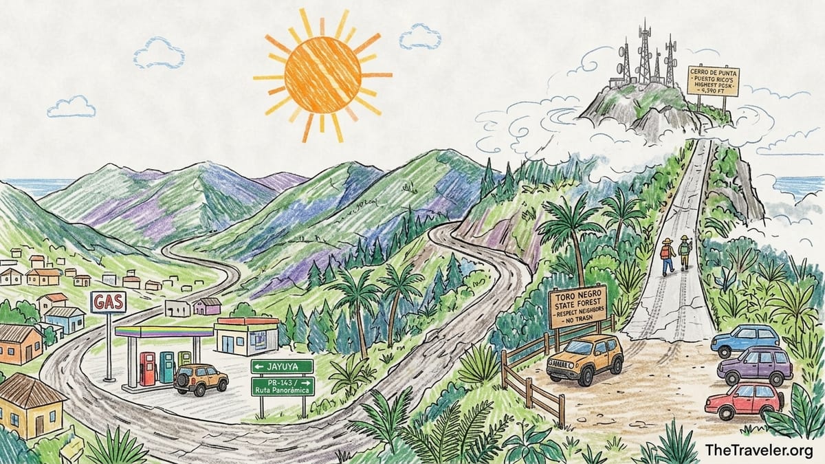
Setting out from Jayuya: Road Choice, Fuel and Timing
I based myself in Jayuya’s center the night before, because this high mountain town sits naturally below Cerro de Punta and makes a logical jumping-off point. In October 2026 I paid around 100 US dollars for a simple room in a small guesthouse a short drive from the plaza. Before leaving town I topped up fuel; gas around Jayuya was posting prices near 3.30 dollars per gallon, similar to what I had seen elsewhere in the interior, and I did not pass any additional gas stations once I started gaining serious elevation toward the Ruta Panorámica along PR‑143.
From Jayuya’s urban core I followed local signs for PR‑144 and then PR‑149, climbing into tighter switchbacks and cooler air. These highways are paved but narrow, with frequent blind curves and almost no shoulder. The drive from central Jayuya to the junction with PR‑143 took me about 35 minutes, including one brief pullout stop to let a truck pass. I was in a compact rental SUV with automatic transmission; I did not strictly need four‑wheel drive for traction, but the higher clearance and engine braking were reassuring in the steepest sections.
I turned onto PR‑143, the mountain segment of the Ruta Panorámica that threads the spine of the Cordillera Central. Signage for Cerro de Punta from the Jayuya side is subtle. There was no big highway sign for a national park or formal trailhead when I visited, only small roadside notices for the Ruta Panorámica itself and a scattering of kilometer markers. Because this road is scenic and slow, I planned conservatively and left Jayuya at 1:15 p.m., reaching the vicinity of the Cerro de Punta access road a little after 2:00 p.m., with several hours of daylight in hand in case of weather changes or delays.
Along the way I passed the kind of real-world features that matter when you are planning: one neighborhood minimarket at lower elevation, several houses with dogs that barked as I crawled past, and a handful of informal viewpoints where locals had parked to look down toward Jayuya’s valley. None of these were suitable long-term parking areas for the hike itself, but they gave me confidence that, while remote, this is still a lived‑in landscape rather than a wilderness road with no help nearby.
Finding the Access Road and Deciding Where to Park
Cerro de Punta sits on the boundary between Jayuya and Ponce, with its high slopes inside Toro Negro State Forest. Access from the Jayuya side is by way of PR‑143, near the 17‑kilometer point, where a narrow service road climbs to communications towers near the summit. This is not signed like a traditional hiking trail. What I found in October 2026 was a tight concrete and gravel lane angling sharply uphill on the south side of PR‑143, with a small, flat dirt area on the opposite shoulder where two cars were already parked nose‑in.
The parking area at the base of this access road is informal but clearly used. There were no meters, barriers or official fee signs, and no attendant; access remained free on the day of my visit, matching recent descriptions that treat Cerro de Punta as a walk‑in destination without an entry charge. I did not see any current “no parking” notices or private property warnings at this pullout. A hand-painted board on a nearby fence mentioned Toro Negro and asked visitors to respect neighbors and take their trash, a reminder that this is a shared space between residents and hikers rather than a large, purpose-built car park.
Standing at the junction, I had to make the same decision every visitor faces: attempt to drive up the service road or walk it. The first 20 meters were brutally steep and scarred, a patchwork of aging concrete, exposed aggregate and broken edges, no wider than a single vehicle. I watched one small sedan attempt the start, spin its tires slightly and then reverse back down to park beside me. On this basis, and having read recent warnings about the condition of this lane, I chose to leave my SUV in the lower parking area and treat the service road itself as the hike.
This choice turns Cerro de Punta into a short but concentrated ascent on foot. Starting around 4,000 feet above sea level on PR‑143, the access lane climbs approximately 300 to 400 vertical feet in around 0.6 to 0.7 miles each way. In other words, you are not undertaking a 4,390‑foot mountain ascent from the sea. The key is to be honest about that difference: you are visiting a high point that has road access, not completing a long alpine expedition. It still feels serious because of steepness, exposure to cloud and weather, and the remoteness of the surroundings, but in length and time it is more akin to a neighborhood hill climb than a full‑day trek.
Walking the Steep Service Road: Surface, Steepness and Vegetation
I locked the car at 2:15 p.m., packed one and a half liters of water, a light rain shell, a thin fleece, a hat and a small snack, and started walking up the service road. The surface alternated between old poured concrete and rougher patches where runoff had eaten channels into the pavement or left broken chunks tilted at odd angles. In dry conditions I had no traction problems in trail shoes with a reasonable tread, but I was glad of poles on the descent; on a wet day, this same route would become slick and would reward slower, more deliberate foot placement.
The grade is immediately steep. The first ten minutes felt a little like climbing a long, uneven staircase without steps, just a continuous ramp tilting toward the sky. My GPS watch later showed that in just over half a mile I gained roughly 350 vertical feet, which matches the impression of a sustained climb. There are no sheer drops right at the road edge, but on the downslope side vegetation falls away quickly, and in several places I could look through breaks in the brush and see the highway far below, a reminder that a stumble into the brush would still be nasty even without a cliff.
Vegetation changed as I climbed. The access road cuts through the fringe of the Toro Negro cloud forest, and the difference from the coast is dramatic. Even in October’s shoulder season, sierra palms leaned over the lane, bromeliads clung to mossy branches and low, wind‑gnarled trees formed a broken canopy. Grasses and shrubs encroached on the pavement in several hairpins, brushing my calves as I passed. Birdsong carried across the slope, but there were few insects compared with the lowlands, likely due to the cooler air and frequent cloud cover at this elevation of more than 1,300 meters.
I passed one small concrete platform with what looked like a disused utility structure, and two sharper bends where the road twisted around the shoulder of the mountain and briefly eased in angle. These made natural places to pause and drink, and I saw fresh tire marks indicating that some local vehicles still grind up here, likely for tower maintenance rather than tourism. The overall impression was of a functional service road that hikers are currently tolerated on, rather than a signed recreational trail.
Summit Area, Views and the Reality of the Elevation
After around 30 minutes of steady walking with two short breath stops, the grade eased and the service road crested at a cluster of communications towers and low buildings. The true high point of Cerro de Punta, at around 1,338 meters or roughly 4,390 feet above sea level, hides a few meters above the road itself, accessible by walking onto a slightly higher concrete pad and adjacent knoll behind a low barrier. There was no staffed facility or ranger; only a faded sign referencing the elevation and the fact that this is Puerto Rico’s highest point.
It is important to be precise about the ascent involved. I began the walk from just below the 1,220‑meter contour, near PR‑143’s high point. Over the course of the climb I gained only about 120 vertical meters. The feeling of being “over 4,000 feet up” is real, because the surrounding valleys drop sharply and the air is distinctly cooler and more humid than on the coast. But as a physical effort this is not a massive vertical gain. Travelers used to long mountain days in places like Colorado or the Alps should see it as a short leg‑stretcher rather than a big summit push. For coastal visitors unused to steep grades, it will feel punchy but manageable.
On my visit the cloud ceiling wavered right around summit level. When I first arrived, low cloud filled the valleys and lapped at the tower bases, obscuring any long-range views. After ten minutes the cloud thinned, and for several minutes at a time I could see southward over the folds of the Cordillera Central, with Ponce hidden behind ridges but a suggestion of the Caribbean plain beyond. To the north, breaks in the mist briefly opened a view toward the interior plateau and, far on the horizon, paler light where the Atlantic side of the island lies. Under perfectly clear early morning conditions, locals and guides report that both coasts can be seen at once, but on my mid‑afternoon autumn visit the air never became that transparent.
Even with partial views, the summit area felt atmospheric. The wind picked up noticeably compared with the road, funneled between tower structures and whipping low clouds across the ridge. Temperatures hovered in the high teens Celsius, around 65 degrees Fahrenheit, a drop of at least ten degrees from lowland Ponce and San Juan that day. I was comfortable in a light fleece under a wind‑resistant shell when standing still, and I saw one local visitor wrap up in a heavier hoodie after arriving hot from the climb in a t‑shirt. The contrast between the bustling seaside heat and this damp, cool cloud forest environment is one of Cerro de Punta’s biggest draws.
Weather, Clothing, Children and Suitability for Inexperienced Walkers
My October 2026 hike took place in the shoulder of the wetter season, and the pattern I experienced seems typical for the central cordillera. Mornings often start with the clearest skies, with clouds building from late morning and thickening into afternoon. I had light drizzle on the drive and during the first five minutes of the climb, followed by drier but overcast conditions and frequent fast‑moving fog at the top. Wind was moderate, enough to tug on my hood and send cooler air down the back of my neck when I faced south.
Because of this variability, I would not treat Cerro de Punta like a casual urban walk, even though it is short. For clothing, a realistic minimum kit is a breathable t‑shirt, a light long‑sleeve or fleece layer and a simple waterproof or windproof shell you can pull on at the summit. Running shoes are adequate in dry weather, but anything with a more aggressive tread will make the descent feel safer. I took one and a half liters of water for a 90‑minute round trip including stops, drank about half, and ate a small snack at the top; if you are bringing children or hiking on a hotter day, carrying two liters per person is more comfortable.
In terms of difficulty, the route is short but steep and does not offer many flat rest sections. An averagely fit adult who walks occasionally should be able to reach the summit from the parking area in 25 to 40 minutes at an unhurried pace. Children who are used to walking uphill and are at least seven or eight years old can handle the grade, as long as they are supervised closely, especially on the descent when tired legs and the smooth concrete surface invite slips. I would be more cautious about bringing very young children, frail older relatives or anyone with balance issues; in those cases, driving only partway up with a high‑clearance vehicle and walking the final, less steep section might be the better compromise if conditions and signage allow.
Inexperienced walkers should be prepared for how hard steep pavement can feel compared with a flat seaside promenade. During my own climb I passed a couple from San Juan who told me they rarely hike; they were breathing hard and paused several times, but they did reach the top in about 40 minutes and felt very satisfied. What made it pleasant for them was taking frequent short breaks, having enough water and wearing comfortable, closed shoes. What could have made it unpleasant would have been rain, slick concrete and rushing the pace to “bag the highest peak” too quickly.
Access Rules, Private Land and the Option to Park Lower
One of the most important realities about Cerro de Punta is that it is reached by service roads rather than a dedicated national park trail. The final lane I walked up in October 2026 clearly serves communications towers and infrastructure at the summit. There were no gates across the road during my visit, and no current signs forbidding pedestrian access, but there were also no official welcome panels inviting hikers. That absence matters. Road and land status can change, especially after storms, landslides or infrastructure upgrades, and visitors should not assume that any road or track they see is automatically open for recreation.
The most responsible approach is to treat the paved access lane as a privilege, not a right. From Jayuya, you will likely find the same informal parking pullout where I left my vehicle. If, on arrival, you encounter a new barrier, a clear “no trespassing” or “propiedad privada” notice, or staff working on the towers who ask you not to proceed, the correct response is to turn back rather than trying to sneak past. Cerro de Punta also lies within or adjacent to Toro Negro State Forest, which has its own web of regulations that can be updated by the Department of Natural and Environmental Resources; checking locally in Jayuya or Orocovis before driving up is prudent.
Given the poor surface and severe gradient of the access lane, parking at the lower pullout remains the option I would recommend, even for confident mountain drivers. Attempting to drive the full way introduces the risk of stalling or spinning tires on the steepest sections, scraping the undercarriage on broken concrete edges, or having to reverse down a one‑lane ramp with limited visibility if you meet another vehicle. From my perspective, walking that last stretch is not just safer, it is also more enjoyable; you get to feel the cloud forest around you and are less anxious about the road.
I did not pay any fees on my visit. There were no rangers collecting money, no toll booth on PR‑143, and no parking charge box. I also did not see any guides advertising services on the roadside. Some local tour operators in Jayuya and Ponce do offer guided mountain days and can include Cerro de Punta as a stop; prices quoted elsewhere in 2026 for small‑group central-mountains excursions ran roughly between 75 and 150 dollars per person depending on group size and inclusions. If you prefer to have a driver handle the mountain roads and navigate the sometimes confusing junctions, hiring such a service remains a valid alternative to self‑drive, as long as you confirm that they operate with landowners’ permission.
Time on the Mountain, Descent and Practical Takeaways
From leaving my car at 2:15 p.m. to returning to it after the hike, I spent just about one hour and thirty minutes on the mountain. The ascent itself took 32 minutes of walking time, with roughly five minutes of rest stops to drink and take photos. I then lingered on the summit plateau for around 20 minutes, waiting for gaps in the fog and exploring the concrete pads, before descending in about 18 minutes at a controlled but brisk pace using trekking poles. Add in a few minutes at the car to change layers and check the vehicle, and it was a tidy, concentrated outing within an afternoon.
The descent was the only part that surprised me physically. Walking downhill on such steep concrete engages different muscles, and without poles I would have been tempted to lean back and plant my feet harder, which increases the risk of a slip. With simple aluminum trekking poles, I could keep my steps short, land more softly and use the poles to steady myself in the eroded gutters along the road edge where loose gravel had collected. Anyone prone to knee discomfort on descents should be aware that this short walk still loads the joints heavily on the way down.
Back at PR‑143, the atmosphere felt relaxed. One of the local cars that had been parked when I arrived had already left; another group of three friends in sports clothes appeared just as I was taking off my shell, having made the climb slightly faster than I did. We chatted briefly in Spanish about the views. Like me, they had seen only partial glimpses of the coasts, but they were still thrilled simply to stand at Puerto Rico’s highest point and feel the cloud wash past them. For them, the combination of a mountain drive along the Ruta Panorámica, a short but intense walk and a tangible high summit ticked the box for a central‑mountains adventure day.
From a planning standpoint, I would allow half a day for the excursion if you are based in Jayuya: one to one and a half hours of driving each way depending on where you start in town, plus up to two hours for the walk and summit time. That still leaves time in the same day to visit other Jayuya sites such as the Taíno petroglyphs at Piedra Escrita or the Museo El Cemí. If you are driving from San Juan or Ponce, you can fold Cerro de Punta into a long day that samples the broader Toro Negro region, but you should be conservative with timing and avoid trying to squeeze it in at dusk, when visibility on PR‑143 deteriorates and afternoon fog can thicken quickly.
The Takeaway
What surprised me most about Cerro de Punta from Jayuya was the contrast between how modest the walk is on paper and how “big mountain” it can feel in the moment. The ascent from the roadside is short, and the total vertical gain modest compared with classic hiking peaks elsewhere. Yet the steepness of the service road, the sudden temperature drop, the cloud forest vegetation and the sense of being on the island’s literal high point combine to give the outing a weight far beyond its numbers.
For me, the views did justify the journey, even though I did not catch the legendary crystal‑clear window when both the Atlantic and Caribbean coasts are perfectly visible. Standing in broken cloud, with brief glimpses of the southern lowlands and the layered ridges of the Cordillera Central, was enough. It helped that the drive along PR‑143 itself is a destination, a winding line across the spine of Puerto Rico that feels a world away from the beaches yet reachable in a few hours from any major city on the island.
The conditions that made the route harder were primarily the wet patches on the steep concrete and the swirling fog at the top. In full sun on a dry, breezy winter day the climb would be straightforward for most reasonably active visitors, but in heavy rain or strong wind I would seriously consider turning back, particularly if traveling with children or less steady walkers. Because the route relies on a service road across land that is partially private and partially managed for infrastructure, I would also keep an eye on any future changes in access and be prepared to accept a gate or sign that might one day close this particular approach.
Would I return? Yes, but I would do it differently. Next time I would aim for a cool, dry morning in the December to March period, leave Jayuya before dawn and arrive at PR‑143 near Cerro de Punta as the first light hits the ridge. I would bring a slightly warmer layer, the same simple kit of water and snacks, and the patience to wait at the top for the clouds to open. Even if they did not, the combination of driving through Puerto Rico’s central mountains and stepping out into the cloud forest at over 4,000 feet would still feel like one of the island’s essential mountain experiences.
FAQ
Q1. How long does the hike to Cerro de Punta from the Jayuya side take?
The walk from the informal parking area on PR‑143 up the steep service road to the summit area usually takes 25 to 40 minutes each way for an averagely fit adult, with additional time at the top for views and rest.
Q2. How much elevation do you actually gain on the hike?
Although Cerro de Punta stands around 4,390 feet above sea level, the common approach from PR‑143 begins near 4,000 feet, so you only gain roughly 300 to 400 vertical feet on foot.
Q3. Do you need a 4x4 vehicle to reach the starting point?
You do not strictly need four‑wheel drive to reach the lower parking pullout on PR‑143, but a higher‑clearance vehicle is helpful on the steep, winding mountain roads, and most visitors leave their car there instead of driving the final access lane.
Q4. Is there a parking fee or entrance charge for Cerro de Punta?
At the time of my October 2026 visit there was no parking fee at the informal pullout on PR‑143 and no entrance charge for walking up the service road, though conditions and regulations can change.
Q5. Are the service roads and summit area officially open to hikers?
The final stretch follows a service road to communications towers, across land not managed as a traditional hiking park. There were no signs forbidding pedestrian access during my visit, but visitors should always respect any future gates, private property notices or instructions from workers.
Q6. What should I wear and bring for the hike?
Wear comfortable closed shoes with decent tread, a breathable top, a light insulating layer and a wind or rain shell. Carry at least one to two liters of water per person and a small snack, even though the hike is short, as weather and exertion can make it feel demanding.
Q7. Is Cerro de Punta suitable for children and inexperienced walkers?
The route is short but steep. Active children around seven or eight years old who are used to walking uphill can usually handle it with supervision, but very young children, people with balance issues or anyone uncomfortable on steep pavement may find it challenging, especially on the descent.
Q8. When is the best time of day and season to go?
Mornings in the drier months from December to March generally offer the clearest conditions, with fewer clouds around the summit. Afternoons and wetter months, like October when I visited, tend to bring more fog and drizzle.
Q9. Can you really see both the Atlantic and Caribbean from the summit?
On a very clear day with low humidity, especially in the cooler dry season, it is possible to see toward both the northern and southern coasts from Cerro de Punta, but on hazier or cloudier days you may only glimpse distant lowlands rather than distinct shorelines.
Q10. Do I need a guide to hike Cerro de Punta from Jayuya?
A guide is not required for the short walk from PR‑143, and confident drivers with basic navigation can manage independently. However, if you prefer not to drive mountain roads or want local context about Jayuya and Toro Negro, hiring a reputable local guide service can add value and peace of mind.